background image

13

flashes until the Geosat is fully charged. 

ATTENTION  when  the  device  encounters 
internal  temperatures  of  higher  than  60°, 
the  battery  will  not  recharge  and  an  alarm 
message will be displayed. This can happen 
if  the  navigator  is  exposed  for  a  long  time 
to  direct  sunlight  in  hot  weather.  In  such 
cases, it is suggested that you switch off the 
navigator to recharge the battery.

Battery Functioning

Geosat  battery  allows  the  navigator  to 
operate  even  without  feeding  it  with  the 
power supply cable.
When  the  navigator  is  used  without  power 
supply, an icon (battery) indicating the level 
of  charging  of  the  battery  is  shown.  If  this 
icon is half green, the level of charge of the 
battery is equal or less than half, if the icon is 
fully green, it means that the level of charge 
is more than half. 
When  Geosat  for  ALL  is  fed,  another  icon 
(plug with batteries) is shown. There are two 
status: if the icon is coloured in yellow, the 
battery  is  recharing,  if  the  icon  is  coloured 
in  green,  it  means  that  the  battery  is  fully 

charged. 

The  maximum  autonomy  of  the  battery  in 
optimal  conditions  ranges  from  30  minutes 
to 2 hours (according to the usage patterns). 
It is possible to extend the autonomy of the 
battery optimizing the energetic waste: in the 
system setup it is possible to choose among 
three  levels  of  power  save  (no,  medium, 
maximum).

3.1 Starting

1.

 Switch  on  the  navigator  by  pressing  the 

POWER

 button.

2.

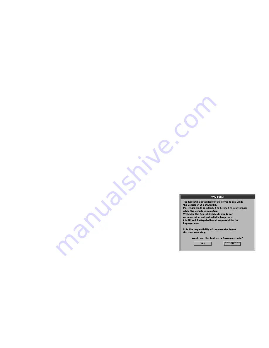
  Geosat  will  display  the  software  and 

cartography  display  screen  and  then  the 
user is asked to choose the desired mode: 
passenger  or  driver.  An  unaccompanied 
driver should select the Driver mode. 

3. 

Select  one  of  the  two  buttons  with  the 

JOYSTICK

  using  the  left  or  right  arrow. 

The selected button is outlined by a dotted 
line. 

4. 

Press 

ENT

 to confirm.

5.

 Wait for the satellite search to be completed 

to see your position on the map.

3. Set the destination

Summary of Contents for Geosat 4 ALL

Page 1: ...USER MANUAL AvMap GEOSAT 4 ALL AvMap GEOSAT 4 CAMP AvMap GEOSAT 4 TRUCK Ver 0 2 ...

Page 2: ......

Page 3: ...you will be able to receive your GPS position and view it on detailed Tele Atlas mapping set your destination and be guided by written prompts and voice instructions plan a complex trip obtain a list of nearby points of interest stroke your favourite location as marks on the map use the display to see movies or pictures and much more ...

Page 4: ...19 5 4 Navigating Off road 20 5 5 Detour 20 6 Using the map 6 1 Exploring the map 21 6 2 Map Views 21 6 3 Driving mode 23 6 4 2D and 3D views 23 6 5 Night vision 23 6 6 Points of Interest POI 24 7 Managing Marks 7 1 Creating Marks 24 7 2 Mark folders 25 7 3 Mark list 25 7 4 Editing a Mark 26 7 5 Setting a Mark as HOME 27 7 6 Mark alarm 28 7 7 Sending and receiving Marks 28 7 8 File manager 28 8 Ad...

Page 5: ...11 5 Routing 42 11 6 Track 42 11 7 Alarms 43 11 8 Date Time 44 11 9 Units 44 11 10 Text and Voice language 44 11 11 Simulator 45 11 12 Interface 45 11 13 TMC 46 11 14 Brightness 46 11 15 Volume 47 12 Updating Software and map 12 1 Updating the Software 47 12 2 Updating the Map 48 13 Troubleshooting 13 1 Ram Clear 49 13 2 Reset 50 14 Warranty and Support 14 1 Warranty conditions 50 14 2 Repair and ...

Page 6: ...or in positions that may obstruct the driver s view Do not place the navigator in positions that may interfere with the correct functioning of the security safety equipment of the vehicle e g airbags Make sure that the navigator is correctly attached to the bracket before driving Do not rely exclusively on vocal instructions Depending on a variety of factors speed weather GPS reception etc these i...

Page 7: ...ot recharge it at temperatures higher than 60 C THE LI ION BATTERY PROVIDED WITH THE PRODUCT MUST BE RECYCLED OR DISPOSED IN THE CORRECT WAY WEEE Waste of Electric and Electronic Equipment The symbol shown here and on the box indicates the conformity to the WEEE directive Do not dispose of this WEEE product as domestic waste some substances contained in electronic equipment can damage the environm...

Page 8: ...e control 7 TMC receiver 8 This manual 1 2 Available accessories 1 Fixed holder 2 Carrying case 3 External GPS antenna 4 Maps updates on DVD 5 AC DC Adaptor 6 TV Tuner 1 3 Hardware features Looking at the navigator you can see the following components 1 Keyboard 2 5 6 LCD TFT display 3 Infrared sensor 4 Audio output 1 Introduction N B images are for illustrative purpose only 1 2 3 4 5 6 3 4 5 7 1 ...

Page 9: ... into cursor mode or GPS mode JOYSTICK Upper arrow moves the cursor up Lower arrow moves the cursor down Right arrow moves the cursor right Left arrow moves the cursor left ENT confirm a choice or selection opens the function menu zooms in the map zooms out the map INFO opens the full info window MODE switches among the different viewing options for map instruction and trip computer pages PAGE swi...

Page 10: ...t arrow moves the cursor toward the upper left corner Lower right arrow moves the cursor toward the lower right corner Lower left arrow moves the cursor toward the lower left corner zooms in the map zooms out the map FIND opens find window to search for addresses marks POI INFO displays the complete info on the point on the map indicated by the pointer MODE allows entry to in advanced functions av...

Page 11: ... is also an optional fixed holder available upon request In either case please follow the following instructions Place the navigator in a position high enough not to represent a risk of distraction from driving Make sure that the bracket does not represent a danger in case of accident or sharp braking Make sure that the bracket the navigator and the cables do not interfere with the safety devices ...

Page 12: ...nd plug into the Geosat 2 3 Power connection Whilst the Geosat is equipped with a built in Li Io rechargeable battery it is recommended that you power the unit via the car cigarette lighter 12 V power socket during your journey Geosat comes with the battery uncharged but the navigator can be used right away with the car charger The battery will require 4 hours charging to be fully charged Geosat c...

Page 13: ...her icon plug with batteries is shown There are two status if the icon is coloured in yellow the battery is recharing if the icon is coloured in green it means that the battery is fully charged The maximum autonomy of the battery in optimal conditions ranges from 30 minutes to 2 hours according to the usage patterns It is possible to extend the autonomy of the battery optimizing the energetic wast...

Page 14: ...mmediately 3 2 Setting the first destination To plan a route the easiest and fastest way is take the current GPS position as the departure point and insert the desired destination 1 Press the FIND button The Find menu will now open 2 In the Find menu select Address and press the ENT button 3 The Find address menu will now open The Country field is outlined with a dotted line Press the ENT button 4...

Page 15: ...ton is useful for viewing the inserted address on the map 1 Select Show on Map and press the ENT button 2 Once the address has been checked it can be set as destination ensure that the cursor is on the required destination and press MENU 3 The Navigation menu will now open From Navigation from My position select Set destination on cursor and calculate and press the ENT button The Geosat will calcu...

Page 16: ...parture and press 4 Planning a route the ENT button How to set the destination 1 Once the departure has been set return to the Find address menu Insert the destination address following the same procedure as for the departure then press MENU button 2 The Find menu will now open From Route planning select Set as destination and calculate and press the ENT button 4 2 Deleting a route To delete the l...

Page 17: ... the ENT button to confirm 3 Press the ENT button to start the simulation 4 Select Speed with the JOYSTICK and press the ENT button to confirm 5 Select the numbers with the right and left arrow and set the value with the up arrow or down arrow For further details read par 11 11 5 1 Via points If you want to set a sequence of destinations or if the route viewed on the map does not meet your needs y...

Page 18: ...elect Remove next Via point to remove the next via point 5 Press the ENT button to confirm The Geosat will calculate the new route You can set the Via point s first and then the departure and destination points or set the departure point and then the Via point s fol lowed by the destination Via points must be entered in the correct sequence Woking add Woking as a Via point and the route will recal...

Page 19: ...s linked by a red line How to remove a block from a road 1 Place the cursor on the blocked road 2 Press the MENU button The Navigation menu will now open 3 Select Advanced options and press the ENT button to confirm 4 The Advanced route planning menu will now open From Blocked roads select Remove blocked road on cursor and press the ENT button to confirm If more than one road has been blocked you ...

Page 20: ...flies between point A and B on the map 1 Press the centre of the JOYSTICK The Function Menu will now open 2 Select A B Function and press the ENT button to confirm An A will appear in place of the selected point on the Map 3 Move the cursor to another point on the map repeat steps 1 and 2 to set the point B 4 A B will appear in place of the set point on the Map and it will be linked to the A point...

Page 21: ...l of the Map that is to say the quantity of information displayed 1 Press the MENU button three times to open the System Setup menu 2 Move the JOYSTICK rightwards to select the Map folder 3 Select the submenu Map Detail and press ENT to confirm 4 Select with the JOYSTICK simple normal or full In the same window in the Fix Symbol submenu it is possible to customize the icon representing the vehicle...

Page 22: ...PAGE button you can pass the maneuver pages then pressing the MODE button you can obtain the following configurations Full display instruction List of instructions Pressing the PAGE button you can pass the trip computer pages then pressing the MODE button you can obtain the following configurations ...

Page 23: ...iew can only be used for navigation with a GPS signal while consultation of the map and simulation take place in 2D When in 3D view if you press ESC to move to cursor mode the view automatically changes Graphic of speed to 2D press ESC to return to 3D view To set the map view read par 11 3 6 5 Night vision With Geosat it is possible to set the night vision for a safer consultation and driving at n...

Page 24: ...n you are in an unfamiliar place This information is preloaded in the Geosat together with the cartographic data The POIs include hotels restaurants hospitals police stations cinemas etc and are grouped in these categories Car services Transports Emergency Attractions Entertainment Food and drink Government Lodging Medical services Natural attractions Services Shopping Sport facilities Other To se...

Page 25: ...ice select Marks List and press the ENT button to confirm 2 In the Mark folder list select the desired folder and press the ENT button Press the MENU button to open the Mark list menu from which you can Show on map Set a Mark as destination or use two or more marks to set a route the desired address 3 Press the centre of the JOYSTICK The Function menu will now open Select Add Mark on cursor and pr...

Page 26: ...ess the ENT button to open the virtual keyboard Write the name of the folder selecting letter by letter with the JOYSTICK When the name is complete select ENT on the virtual keyboard and confirm by pressing the ENT button then select OK and again confirm by pressing the ENT button 4 Select Description and repeat the same procedure described as for the Name Press the ENT button to open the Marks op...

Page 27: ...e a Mark 1 Select the Mark you want to remove with the cursor or from marks list as described above 2 Press the centre of the JOYSTICK The Function menu will now open 3 Select Remove Mark and press the ENT button to confirm A warning window will now open If you are sure you wish to remove the Mark select OK and confirm by pressing the ENT button How to move a Mark A Mark can be moved to another po...

Page 28: ...rm 3 Select Mark alarm and press the ENT button to confirm In the Alarm radius field you can set the radius within which to activate the alarm For further details read par 11 7 Only Marks associated to the danger icon can be alerted 7 7 Sending and receiving Marks There is an accessory software called PCPlanner that makes it possible to transfer marks and data from a PC to Geosat and vice versa Th...

Page 29: ...he Marks It is possible to save up to 1000 Marks After a RAM clear or a software update you can reload previously saved Marks 1 Press the MENU button twice select File manager and press the ENT button to confirm 2 Select the saved file that contains the Mark to be reloaded Press the MENU button The File menu will open 3 Select Load and press the ENT button A warning message will open To load the M...

Page 30: ...e current GPS position toward the found intersection 7 Alternatively select Show on Map and press the ENT button Once the intersection has been found it can be set as destination Press the MENU button The Navigation menu will open From Navigation from my GPS position select Set as destination and calculate and press the ENT button to confirm 8 4 Searching near to the cursor or to the GPS position ...

Page 31: ...t GPS position will open Choose the desired city To set it as destination 1 Press the MENU button The Find menu will open 2 From Navigation from my GPS position select Set as destination and calculate and press the ENT button to confirm Alternatively select Use in Find address to open the Find address page filled with the chosen cities At this point the remaining fields can be completed 8 6 Search...

Page 32: ...r the Point of Interest which gives address and telephone number details 8 7 Searching POI by name It is possible to search the Points of Interest database for e g a restaurant a hospital or a hotel by name 1 Press the FIND button The Find menu will open 2 From By Name select POI and press the ENT button 3 The POI category window will open 4 Select a category with the cursor and press the ENT butt...

Page 33: ...rks near to the cursor or to the current GPS position Once the desired Mark has been chosen it can be set as destination 1 Press once the MENU button 2 The Find menu will open From Navigation from my GPS position select Set as destination and calculate and press the ENT button to confirm 3 The Mark by name menu will open The Mark name is outlined with a dotted line Press the ENT button to open the...

Page 34: ... to search a point by its LAT LON coordinates 1 Press the FIND button The Find menu will open 2 Select LAT LON and confirm by pressing the ENT button 3 To insert the coordinates move the cursor upwards or downwards 8 10 Recently found In Recently found you can find the list of the last found addresses Marks and POI 1 Press the FIND button The Find menu will open 2 Select Recently found and press t...

Page 35: ...ed in the column on the right hand side of the display 9 Trip information 1 Ensure that the right hand column is displayed on the screen If it is not press PAGE until it is displayed 2 Press the MENU button twice Select Setup data boxes and press the ENT button to confirm 3 Select from the right hand column the data box to be modified and press the ENT button 4 In the left hand window select the n...

Page 36: ...er the value the higher the precision From the GPS page press the MENU button to open the GPS Menu page from which you can reinitialise the satellite receiver or restart the GPS Time Count down timer Time Elapsed timer Navig Current speed Navig GPS status Navig Altitude Navig Fix Lat Lon Coordinates of current position Navig Cursor Lat Lon Coordinates of the cursor Navig Course The direction of th...

Page 37: ... Setup menu 3 Move the cursor rightwards to select the Interface folder and confirm by pressing 10 Special functions the ENT button 4 In the Interface submenu select with the TMC and press ENT to activate it How to set the TMC alarm 1 Press three times the MENU button to open the System Setup menu 2 Move the cursor rightwards to select the TMC folder and confirm by pressing the ENT button 3 Select...

Page 38: ...00A e TH D7AG The radio equipment has to be connected to the TMC serial port To configure the communication protocol of the serial port 1 Press three times the MENU button to open the System Setup menu 2 Move the JOYSTICK rightward to select the Interface folder 3 Select with the JOYSTICK Radio link and confirm by pressing ENT 4 Press ESC to exit from the System Setup menu Transmit and receive pos...

Page 39: ... ENT The selected mark will be set as destination even if it is moving the software will update constantly its position and follow it 10 5 Connection to GSM localization devices All the functions available with the Radio link are also available for GSM localisation devices 11 Setting preferences 11 1 System setup On the Geosat you can set a variety of preferences allowing you to customize your Geo...

Page 40: ... info avmap it Beeper It activates deactivates the button sounds Power save It sets the level of power save after that the power supply cable has been removed OFF no variation is applied when the power supply cable is removed Medium the brigthness is automatically reduced after that the power cable is removed Maximum the display goes in stand by after 30 seconds of inactivity after that the power ...

Page 41: ... the information in the pre set language External TMC receiver needed Map mode It sets the criteria for the map view North up the 2D map stays fixed with the north up Direction up the 2D map rotates so that the vehicle direction is always facing up 3D View for navigation with a GPS signal the map can display a 3D view with direction up Scale format Type of scale Bar a segment proportional to the i...

Page 42: ...ulating the route you can choose to avoid Toll roads U Turns Highways Walkways Pedestrian areas Ferry routes Built up areas Unpaved roads Turn details With this option checked the screen freezes to show the detail of the forthcoming manoeuvre The turn details are set as off default 11 6 Track On this page you can customize the manner in which the Geosat displays and records the when safety cameras...

Page 43: ...n the memory for Track s recording Track colour Allows selection of the track colour This option is available when the Track display option is checked 11 7 Alarms GPS fix lost alarm Select this option to activate an alarm to alert you to loss of the GPS position Speed alarm Select this option to activate the alarm when you have exceeded a set speed limit The speed limit field determines the limit ...

Page 44: ... to as degrees of the compass 11 10 Text language and Voice Language These folders list the available languages for The Alarm radius determines the distance at which the alarm is activated To modify the radius select the field to be modified and move the JOYSTICK either up or down then confirm by pressing the ENT button 11 8 Date Time Time format 24h or 12h Date format Month Day Year or Day Month ...

Page 45: ...moving the cursor either up or down Route the icon moves along the planned route at the set speed Speed to set the average speed for the simulation Select the speed with the JOYSTICK and then set the desired value moving the cursor either up and down Heading set the heading to be followed only for straight simulation Demo mode when this option is checked a demo of all the navigation functions will...

Page 46: ... bps NMEA 9600 the external serial port is programmed to communicate with a baud rate of 9600 bps 11 13 TMC In this page it is possible to set the TMC alarm radius to get warning messages about the traffic events along the route TMC alarm radius sets the distance within which the TMC events are detected different communication protocols TMC the serial port is set to communicate with an external TM...

Page 47: ... indicated in the first line as V1 xx xxxR dd mm yy while the chart version is indicated in the second to last line as T EUQ xxx xx The next step is to check whether there are updates available from the support section of www avmap it 12 Updating the Software and the Map night vision option is also activated Select the desired option and confirm by pressing ENT The Auto night vision works thanks t...

Page 48: ...ked it will emit an audible signal It should also display the Found New Hardware message Confirm the installation 3 Open the downloaded file This will launch the software update utility and your AvMap Geosat will emit two audible signals and will display the current version of the software and the new one Choose one or more languages from the menu and click on TRANSFER Once you have completed the ...

Page 49: ... instructions Then click on the Transfer to Geosat button 7 Once the transfer is completed close the program and disconnect the USB cable from Geosat 13 1 Ram Clear The Ram Clear is a memory reset that can be carried out in case of fatal error or to reset the memory in order to restore the default settings Attention this operation will delete your Marks if they have not been saved with the File Ma...

Page 50: ...f delivery of the product The date of delivery is taken as the one printed on tax documents receipt invoice or other equivalent issued by the seller to the Purchaser at the point of sale If the product displays a possible Conformity Defect it must be returned to the Support Centre within two months since the finding otherwise the Purchaser will lose the warranty right When the Purchaser verifies a...

Page 51: ...ser s rights under this warranty also regard the aesthetical and or missing components power supply cables but excluding normal wear and tear or inadequate and or inappropriate employ of the mentioned parts above The conditions of this Warranty can only be changed modified or extended in writing by the Producer Each possible controversy deriving and or connected to the previous conditions of the w...

Page 52: ...to the End User or any other party deriving or attempting to derive the structure of the Licensed Products Use duplication except for a single archival copy reproduction disclosure publication distribution or transfer of the Licensed Products other than as specifically allowed The removal or obscuring of any copyright trademark notice or restrictive legend The modification or creation of derivativ...

Page 53: ... products In the event that such exemption is challenged under any such laws this EULA shall be considered breached and any and all right to retain any copies or to use of the Licensed Products shall be terminated and considered immediately null and void Any copies of the Licensed Products held by Licensee shall immediately be destroyed If any court of competent jurisdiction considers this clause ...

Page 54: ... S municipal boundaries product currently marketed as Dynamap Municipal Boundaries as one of the Licensed Products then Licensee shall not use the Municipal Boundaries product to create or derive applications which are used for the purpose of tariff or tax rate determination for a particular address or range of addresses 11 applicable for data of United Kingdom only Licensee shall prohibit the rem...

Page 55: ...ping Authority Public Roads Administration Mapsolutions Switzerland Swisstopo Netherlands Topografische ondergrond Copyright dienst voor het kadaster en de openbare registers Apeldoorn 2004 Products for North America US and Canada 2006 Tele Atlas North America Inc Geographic Data Technology Inc All rights reserved This material is proprietary and the subject of copyright protection and other intel...

Page 56: ...Backlit keyboard Built in speaker Power supply 10 35 V Maximum consumption 7 W Operating temperatures 0 50 C Storage temperatures 25 60 C Dimensions 156 x 110 x 38 2 mm Weight 490 g Appendix A Serial port for optional external GPS antenna Serial port for external TMC receiver Audio video input PAL NTSC Audio output Infrared sensor USB port Minimum PC requirements for software updates Microsoft Win...

Page 57: ...lity Motorways parking area Parking garage Passenger freight airport Gas station Ramp Rent a car facility Rent a car parking Motorway services Truck stop Underground metro station Underground metro station CLF Yacht basin Emergency Emergency medical service Fire station Hospital polyclinic Police station State Police station Attractions Abbey Castle Church City centre Construction Fortress Militar...

Page 58: ...ion centre Elective district Factory ground Free port Industrial activity Post office University School WC Worship Shopping Car dealer Shop Shopping center Vehicle equipment provider Sport facilities Golf course Car race track Horse track Ice skating track Ice skating rink Skating rink Sport hall Sports center Stadium Swimming pool Tennis court Walking terrain Water sport Camp RV Parking Camping C...

Page 59: ...AvMap S r l Via Caboto 9 54036 Marina di Carrara MS Italia ...

Page 60: ...AvMap s r l Via Caboto 9 54036 Marina di Carrara MS Italia info avmap it ...

Reviews: