12
-EN
How to View a Current Display
The navigation map screen usually displays the current vehicle
position and surrounding area.
L
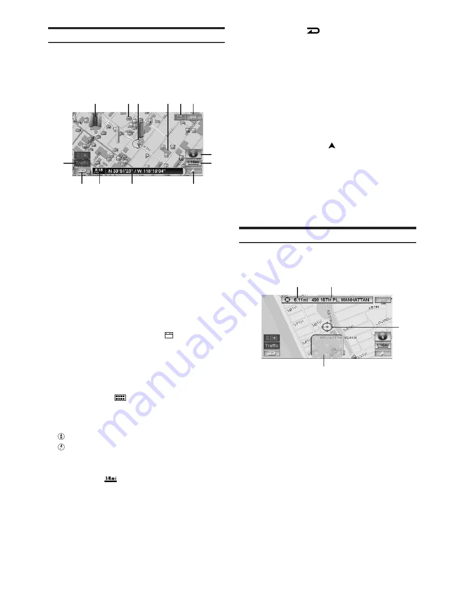
Current Vehicle Position Map (without route)
a
Landmark Icons
The 3D landmark icons can be displayed on the map
when map scale is 1/16 mile (100 m) or less, see
“Landmark Icons” (page 63).
b
POI Icons
The POI icons can be displayed on the map when map
scale is 1/8 mile (200 m) or less, see “POI Icons” (page
62).
c
Current vehicle position icon
d
Building Outlines
The building outlines can be displayed on the map
when map scale is 1/16 mile (100 m) or less, see
“Building Outlines” (page 63).
e
Main Source Screen button (
)
Displays the main source screen of the Alpine touch
panel-compatible monitor. For details, refer to the
Owner's Manual of the Alpine touch panel-compatible
monitor.
If a monitor other than Alpine touch panel-compatible
monitor is connected, this button cannot be used.
f
MENU button (
)
Displays the Nav Menu.
g
Compass Icon
Indicates North and heading mode on the current map.
: North up
: Heading up
(The arrowhead shows the direction of north. To
change the map orientation, see page 14.)
h
Scale Icon (
)
Map scale is shown. (see page 13)
i
Traffic button
*
Traffic Incident List screen is displayed.
*
If the XM Data Receiver HCE-100XM (sold
separately) or the SIRIUS Data Receiver (sold
separately) is connected, the traffic button can be
used.
j
Cancel button (
)
Cancels the current screen and returns to the previous
menu screen.
k
GPS signal state and clock
Current time received from GPS signals; GPS signal
strength (indicated by a dot).
GPS: No satellite information is being received.
GPS
L
: Current position is being calculated.
GPS
LL
: GPS signal 2-D is being received.
GPS
LLL
: GPS signal 3-D is being received.
l
Street name
Name of the current street.
m
Current Map button (
)
Returns to the current position screen.
• When powering on the unit for the first time, it takes the
GPS receiver approximately 10 minutes to calculate the
vehicle’s current position. During this period, the
vehicle position icon may not move even if the vehicle
is being driven.
• For displays during route guidance, see page 38.
Point Display
The point display appears on the screen after you have scrolled
the map. “Entering a Destination by Scrolling Displayed Map”,
see page 30.
a
Distance from the current vehicle position.
Distance in a straight line from the current vehicle
position.
b
Street name on the crosshair icon
If the street name of the crosshair icon cannot be
displayed, the longitude/latitude appears in the display.
c
Crosshair icon
Align the crosshair icon over the place to be searched
by scrolling the map.
d
Scroll pad
The scroll pad is displayed when you scroll the map by
touch operation. Touch [
8
] on the scroll pad to scroll
the map.
Touch [
8
] on the scroll pad to select the location (see
page 30).
The scroll pad is not displayed when using the
remote control.
f
c
g
h
m
j
k
l
d
b
a
b
c
d
a
i
e


