background image

Page 23

How Do I Use It?

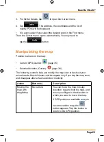
3.  For further details, tap 

 to open the Cursor menu.

4.  Tap 

. The address, the coordinate and the list of  

  nearby POIs will be displayed.
•  It is even easier if you select the desired point in the Find menu.  


Then the Cursor menu opens automatically. You only need to  

  tap the 

 button.

Manipulating the map

Position markers on the map:

•  Current GPS position: 

 (page 35)

•  Selected location (Cursor): 

 (page 36)

The following controls help you modify the map view to best suit your 

actual needs. Most of these controls appear only if you tap the map once, 

and disappear after a few seconds of inactivity.

Action

Button(s)

Description

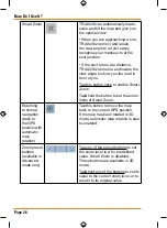
Moving the 

map with 

drag&drop

No buttons

You can move the map into any 

direction: tap and hold the map, and 

move your finger to the direction in 

which you want to move the map.
If GPS position is available and you 

have moved the map, the 


button appears. Tap this button to 

return to the GPS position.

Содержание TRAX436

Страница 1: ...TRAX436 In Car Navigation OWNER S MANUAL...

Страница 2: ...rmation 14 2 Getting started with TRAX436 14 Start using TRAX436 16 Simple and Advanced modes 17 Hardware button Power on off 19 Buttons and other controls on the screen 19 Using keyboards 21 Using th...

Страница 3: ...nel 45 3 Navigating with TRAX436 45 Selecting the destination of a route 46 Selecting the Cursor as the destination 46 Entering an address or part of an address 47 Entering an address Australia 47 Ent...

Страница 4: ...gs 66 Recording the travelled path creating a Track Log 66 Simulating a Track Log on the map 67 Changing the colour of a Track Log 67 Saving a route 67 Loading a saved route 68 4 Reference book Advanc...

Страница 5: ...aged Saved Search Criteria 100 User Data management 100 Settings Menu 101 Map Screen settings 103 Sound settings 104 Route Planning options 105 Regional settings 107 Navigation settings 109 Warning se...

Страница 6: ...urn the screen off or back on the device stays on and can still give directions Press the power button in and hold it for three seconds to turn the device completely off Windshield mount If you do put...

Страница 7: ...ing in the device turns itself on and charges the battery As soon as the power stops for example when you unplug the adapter or turn off your car the device automatically shuts down If you want it to...

Страница 8: ...the road for a few minutes It s a good idea to take valuable items with you when you leave you car that includes GPS devices If you can t take the device with you lock it in the glove compartment or...

Страница 9: ...Page 9 How Do I Put It in My Car Attaching the windshield mount Insert the bracket hook into the notch at the bottom of the device Rotate the bracket up so the head fits into the gap 1 2...

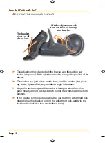
Страница 10: ...up down right and left any just about angle in between Angle the suction cup and the bracket where you want them then push the adjustment lock back down to lock the windshield mount into position If t...

Страница 11: ...o place Gently pull on the mount to 3 make sure it is secure If you have trouble getting the suction cup to stick Clean the spot with an ammonia free cleanser Dry the spot completely use a lint free c...

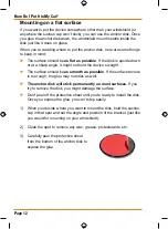
Страница 12: ...e device s weight The surface should be as smooth as possible If the surface texture is too rough the glue may not stick as well The anchor disk will stick permanently on most surfaces If you try to r...

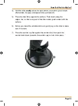
Страница 13: ...the disk firmly against the surface Push down along the 5 edges too so that every part of the disk makes good contact with the surface Before you install the windshield mount gently tug on the disk to...

Страница 14: ...he route TRAX436 has a Safety Mode if you turn on Safety Mode you cannot change anything in TRAX436 while the vehicle is moving at a speed of 10 km h 6 mph or higher Unless only passengers operate TRA...

Страница 15: ...e buttons on the Map screen you can set or reset the zoom value of the button 2D map Tap and hold any of the buttons on the Map screen you can set or reset the tilt and zoom values of the button 3D ma...

Страница 16: ...n any screen Start using TRAX436 When TRAX436 is started the first time you need to do the following 1 Select the written language of the application 2 Select the language and speaker used for voice g...

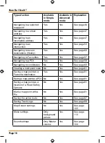
Страница 17: ...60 Use a saved location a Favourite page 57 a POI page 58 the History of previously set destinations and waypoints page 60 Simple and Advanced modes The two operating modes of TRAX436 mainly differ in...

Страница 18: ...s See page 57 Navigating to a POI Yes Yes See page 58 Navigating to coordinates No Yes See page 60 Creating a multi point route No Yes See page 61 Saving a map point as a Favourite destination Yes Yes...

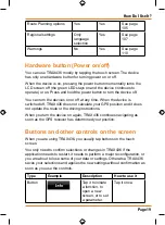
Страница 19: ...off TRAX436 does not calculate your GPS position and it does not update the route or the driving instructions When you turn the device on again TRAX436 continues navigating as soon as the GPS receiver...

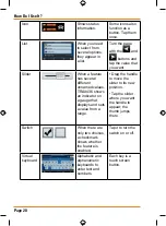
Страница 20: ...l different unnamed values TRAX436 shows an indicator on a gauge that displays and sets a value from a range Drag the handle to move the slider to its new position Tap the slider where you want the ha...

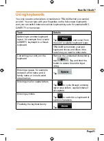
Страница 21: ...ect from the list of available keyboard types TRAX436 remembers your last keyboard choice and offers it the next time you need to enter data Correcting your entry on the keyboard Remove the unneeded c...

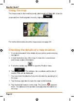
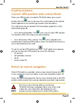
Страница 22: ...ition during navigation 1 Check the bottom line of the map It shows the current street and house number information 2 For further details tap to open the Position menu 3 Tap The address the coordinate...

Страница 23: ...tion page 35 Selected location Cursor page 36 The following controls help you modify the map view to best suit your actual needs Most of these controls appear only if you tap the map once and disappea...

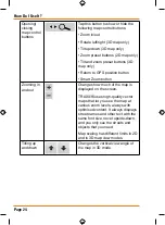
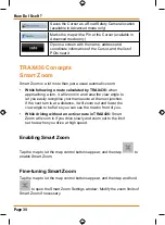
Страница 24: ...on Smart Zoom button Zooming in and out Changes how much of the map is displayed on the screen TRAX436 uses high quality vector maps that let you see the map at various zoom levels always with optimis...

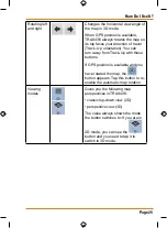
Страница 25: ...can turn away from Track Up with these buttons If GPS position is available and you have rotated the map the button appears Tap this button to re enable the automatic map rotation Viewing modes Gives...

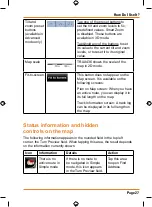
Страница 26: ...ble Smart Zoom Tap hold the button to set the zoom limits of Smart Zoom Returning to normal navigation back to the GPS position with automatic map rotation Tap this button to move the map back to the...

Страница 27: ...screen It is available on the following screens Plan on Map screen When you have an active route you can display it in its full length on the map Track Information screen A track log can be displayed...

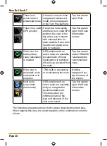
Страница 28: ...d an active route are available but automatic off route recalculation is switched off and you deviated from the route Tap this area to make TRAX436 recalculate the recommended route If the icon is ani...

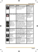
Страница 29: ...an active route are both available this field shows the route event that follows the next route event shown in the above described area Tap this area to open the Itinerary screen with the turn by tur...

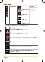
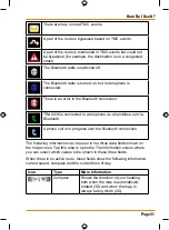
Страница 30: ...he following symbols appear in the Indicator strip Icon Description The sound output of TRAX436 is muted The sound output of TRAX436 is enabled TRAX436 records a Track log when GPS position is availab...

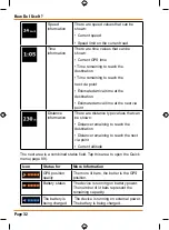
Страница 31: ...ed to a telephone as a handsfree set via Bluetooth A phone call is in progress over the Bluetooth connection The following information can be seen in the three data fields shown on the map screen Tap...

Страница 32: ...istance information There are distance type values that can be shown Distance remaining to reach the destination Distance remaining to reach the next via point Current altitude The next area is a comb...

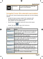
Страница 33: ...In the active route uses the Cursor as the start point by replacing the current GPS position available in Advanced mode only In the active route uses the Cursor as the destination by replacing the pr...

Страница 34: ...d raise the view angle to let you easily recognise your manoeuvre at the next junction If the next turn is at a distance it will zoom out and lower the view angle to be flat so you can see the road in...

Страница 35: ...position errors The direction of the icon is one of the directions of the route To use the current GPS position tap The Position menu appears and you can save the GPS position as one of the following...

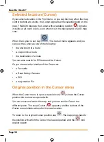
Страница 36: ...f a route a via point in a route the destination of a route You can also search for POIs around the Cursor Or you can save the location of the Cursor as a Favourite a Road Safety Camera a POI a map ma...

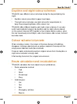
Страница 37: ...tes before sunrise when the sky has already turned bright and a few minutes after sunset before it becomes dark Colour scheme in tunnels When entering a tunnel the colours of the map change All buildi...

Страница 38: ...the route if a TMC event concerns a part of the recommended route For further information about Route Planning options see page 104 Itinerary The Itinerary is the list of the route events that is the...

Страница 39: ...e navigating the route Turns the page for additional list items When the map is open with a manoeuvre in the middle Button Description Zooms in the map Zooms out the map Moves the map to show the prev...

Страница 40: ...avoid it Route demonstrations can be started from the Route menu by tapping the high speed simulation or the simulation at normal speed button POI Points of Interest A point of interest POI is a loca...

Страница 41: ...d or a phone number and additional information can be added to it Tap the following buttons Road Safety Cameras The location of a Road Safety Camera is a special POI They cannot be searched like other...

Страница 42: ...played Camera types There are different types of Road Safety Cameras Symbol Type Description Fixed Some speed cameras stand by the roadside looking in one direction measuring one or both directions of...

Страница 43: ...limit between the two speed cameras you receive the same special warning sound as with the other speed camera types In the rare case TRAX436 cannot register the moment you pass the second speed camer...

Страница 44: ...contain information about the speed limits of the road segments This information may not be available for your region ask your local dealer or may not be fully correct for all roads on the map You ca...

Страница 45: ...tically search the FM radio stations for TMC data and the decoded information will immediately be used in route planning The moment TRAX436 receives traffic information that may affect your route the...

Страница 46: ...the name of the settlement and the search for street names might be faster as well Use a coordinate page 60 Use a saved location a Favourite page 57 a POI page 58 the History of previously set destin...

Страница 47: ...ss If you know at least a part of the address it is the quickest way to select the destination of the route Using the same screen you can find an address by entering the exact address including house...

Страница 48: ...the state Tap the button with the name of the state and select from the list 4 If needed change the settlement To select the settlement from the list of recently used ones tap the button To enter a ne...

Страница 49: ...u The route is then automatically calculated and you can start navigating Entering an address if house numbering is restarted There are long roads where the house numbering is restarted at some point...

Страница 50: ...keyboard 3 Get to the list of search results After entering a couple of characters the names that match the string appear in a list Tap to open the list of results before it appears automatically 4 Pi...

Страница 51: ...ow if a particular house number is in which of them In this case follow the instructions below The procedure is explained starting from the Navigation menu 1 Tap the following buttons Simple mode or A...

Страница 52: ...s After entering a couple of characters the names that match the string appear in a list Tap to open the list of results before it appears automatically 4 Instead of picking one of the streets tap 5 E...

Страница 53: ...tlement from the list of recently used ones tap the button To enter a new settlement 1 Tap the button with the name of the settlement or if you have changed the country state tap 2 Start entering the...

Страница 54: ...int in the middle Tap Simple mode or Advanced mode from the Cursor menu The route is then automatically calculated and you can start navigating Selecting a city centre as the destination The City Cent...

Страница 55: ...tomatically 4 Pick the settlement from the list 4 Tap the button 5 The map appears with the selected point in the middle Tap Simple mode or Advanced mode from the Cursor menu The route is then automat...

Страница 56: ...the ones that are a match appear in a list Tap to open the list of results before it appears automatically 3 Pick the settlement from the list 4 Enter the street name 1 Tap 2 Start entering the stree...

Страница 57: ...the streets is shorter search for that one first You can then find the second one faster You can search for both the type and the name of a road If the same word appears in several names for example i...

Страница 58: ...ode or Advanced mode 2 Select the area around which the POI should be searched The POI will be searched around a given address The map appears with the Cursor in the middle Modify the location of the...

Страница 59: ...line available when you search around a single location sort the list by the distance to drive on route from your current position available when you search along the active route sort the list by the...

Страница 60: ...ally calculated and you can start navigating Selecting the destination from the History The destinations that you have set earlier appear in the History The procedure is explained starting from the Na...

Страница 61: ...ally calculated and you can start navigating Creating a multi point route inserting a via point Multi point routes are created from simple routes so a route must be active first One of the ways of exp...

Страница 62: ...n the destination becomes the start point and all via points are to be reached in the opposite order than before The route is optimised The start point and the destination remain at their position but...

Страница 63: ...points exist you might need to turn the page Tap one of the route points in the list You have the following options Button Action The selected point moves up in the list becomes a via point to be rea...

Страница 64: ...does it for you In Advanced mode you have the following options to enter Plan on Map Via the Find menu tap Via the Route Information screen tap Via the Route Information screen using a shortcut tap Wa...

Страница 65: ...destination or to change settings The only screen control that remains enabled is the gesture that puts you back on the Map screen The procedure is explained starting from the Map screen Tap the follo...

Страница 66: ...iately on the Route Information screen Tap repeatedly until all via points disappear and the button appears Tap it to cancel the whole route Using Track Logs TRAX436 can record the track how your GPS...

Страница 67: ...g recording Simulating a Track Log on the map 1 Tap the following buttons 2 Locate the desired Track Log and then tap the button next to it 3 The map returns and the Track Log simulation a life like r...

Страница 68: ...uring navigation together with the road segments used to reach it To avoid this if you want to save the route you need to save it before you start navigating Loading a saved route This feature is avai...

Страница 69: ...ple to look for the phone number of a POI Route Managing the active route obtaining information about it changing or deleting it or parts of it or planning a route without GPS reception Manage Managin...

Страница 70: ...n Preview that is the next route event Opens the Route Information screen Second upcoming route event Opens the Itinerary Trip data Opens the Trip Information screen Battery status Opens the Quick men...

Страница 71: ...r the Cursor is not at the current GPS position Opens the Cursor menu Open Close Map control buttons Tap this button to show or hide the following map control buttons Zoom in out Rotate left right 3D...

Страница 72: ...able in Advanced mode only Tap one of the preset buttons to set the zoom level to a fix predefined value Smart Zoom is disabled These buttons are available in 2D mode Tap hold any of the buttons to se...

Страница 73: ...tion Sound status muted or enabled Track log recording status TMC reception and processing status Bluetooth connection and communication status Battery GPS position quality and Vehicle type indicator...

Страница 74: ...es TRAX436 is connected to the GPS receiver but the signal is too weak and the receiver cannot determine the GPS position GPS navigation is not possible Only a few satellites are received Position inf...

Страница 75: ...sound output of TRAX436 is muted The sound output of TRAX436 is enabled TRAX436 records a Track log when GPS position is available Track log recording is disabled No TMC receiver is connected or TMC i...

Страница 76: ...ts Turn Preview fields There are two fields reserved on the Map screen to display the next two manoeuvres route events that are listed in the Itinerary Both the type of the event turn roundabout exiti...

Страница 77: ...he number of the exit is shown in the circle but only for the next turn Enter motorway Exit motorway Board ferry Leave ferry Approaching the next via point Approaching the destination In certain situa...

Страница 78: ...scription Elevated roads Complex intersections and vertically isolated roads such as overpasses or underground tunnels are displayed in 3D Terrain Detail Level 3D terrain map data shows changes in ter...

Страница 79: ...If there is no valid GPS position TRAX436 uses the last known GPS position as the start point When you are using a saved route TRAX436 asks you if you want to use your GPS position or the first point...

Страница 80: ...u have added via points the active leg is the part of the route from your current location to the next route point the next via point or the destination if there are no more via points to reach Inacti...

Страница 81: ...oon as you select one point in the Find menu the map appears with the Cursor menu a menu with possible actions for the selected point Alternatively when you tap the map control buttons appear Tap agai...

Страница 82: ...be reached before the destination If there is already a via point in the route the Edit Route screen opens to let you decide where the new via point is to appear in the route If the Cursor is at or n...

Страница 83: ...deletes the Pin the Cursor is near to The Cursor is saved as the location of a Road Safety Camera speed camera or red light camera A new screen appears where you can set the type of the camera the di...

Страница 84: ...e you keep the screen open When you open the screen all fields contain information about reaching your final destination Tap any of the fields to see data on the via points starting from the first one...

Страница 85: ...cannot take into account traffic jams and other possible delays Tap this field to change the content of all data fields to via point information Method This field shows how the route was calculated I...

Страница 86: ...tion screen has both route and travel data you might need during your journey It can be opened directly from the Map screen by tapping the Trip Data field The fields on this screen are continuously up...

Страница 87: ...ining Shows the distance you need to travel on the route before reaching your final destination Tap this field to show it on the map screen in one of the Trip Data fields Time Remaining Shows the time...

Страница 88: ...the current street if the map contains it Tap this field to show it on the map screen in one of the Trip Data fields Opens a new screen with three resettable Trip Computers Tap this button to change t...

Страница 89: ...pdated while you keep the screen open You can switch between the trips pause then resume them or reset their data You have the following functions on this screen Name Description Pauses the trip curre...

Страница 90: ...ngle tap Function tap and hold Master Volume slider Adjusts the sound volume of the device All sounds of the application are involved No action If you only adjust the volume you need to use this butto...

Страница 91: ...s Manage Track Logs Opens the GPS Data screen with satellite information data coming from the GPS receiver and a shortcut to the GPS Settings screen if needed GPS receiver detection is automatic Same...

Страница 92: ...in 2D only the horizontal position is calculated TRAX436 cannot calculate your vertical GPS position Grey TRAX436has a connection to the GPS receiver but GPS position information is not available Red...

Страница 93: ...Coordinates Your current GPS position in WGS84 format n a Status bar for the satellites Dark bars are for the yellow and lit bars are for the green satellites The more satellites your GPS tracks the g...

Страница 94: ...oad and edit your routes Tap the following buttons Button Description Reference Opens a screen with useful route data Page 84 You can browse the driving instructions that TRAX436 follows during naviga...

Страница 95: ...6 stores Tap the following buttons Button Description Reference Renaming or deleting saved routes Page 94 Deleting History items Page 96 Recording simulating renaming or deleting track logs assigning...

Страница 96: ...the list of locations you used lately Tap the following buttons Button Description Deletes the selected item in the History Deletes the entire History Turns the page for additional list items Manage...

Страница 97: ...n with the name of the Track Log Opens a keyboard screen to let you rename the Track Log Tap this button to hide the Track Log on the map No colour will be assigned to the Track Log Tap one of the col...

Страница 98: ...with the product Tap the following buttons Button Description Button with the name of the POI group Opens the list of the subgroups of this POI group The new list behaves the same as this one Button w...

Страница 99: ...roup will be shown on the map Subgroups under the edited POI group will inherit its visibility settings Button with the icon of the POI group Tap this button to select a new icon for the POI group Del...

Страница 100: ...utton with the name of the Saved Search Criteria Tap to rename the saved query Deletes the selected item in the list Deletes the entire list Turns the page for additional list items Tap to save a new...

Страница 101: ...the new information Restore User Data All user data and settings will be overwritten with the information stored in the backup file Data and settings created after the latest backup will be lost Dele...

Страница 102: ...Safety Mode Page 110 You can set up the connection to the GPS receiver Page 112 You can set up the connection to the TMC receiver If the TMC receiver is working you can select the radio station to be...

Страница 103: ...nd use it to plot the route map in 3D when you navigate Landmarks Landmarks are 3D artistic or block representations of prominent or well known objects 3D landmarks are only available in selected citi...

Страница 104: ...me Use the switch to mute all sounds of the device and then to re enable them again The position of the fader determines the volume level Voice Guidance Volume The slider adjusts the loudness of voice...

Страница 105: ...ered for or to be excluded from the route if possible Excluding a route is a preference It does not necessarily mean total prohibition If your destination can only be accessed using some of the exclud...

Страница 106: ...ion Vehicle types Car Taxi Bus Emergency vehicles Bicycle Pedestrians Road Types Used for Route Planning Type Description Motorways You might need to avoid motorways when you are driving a slow car or...

Страница 107: ...Type Description Fast Gives the quickest possible route if you can travel at or near the speed limit on all roads Usually the best selection for fast and normal cars Short Gives a route that has the...

Страница 108: ...ed by the chosen voice guidance language a warning message will appear Set Date Time Format You can set the date and time format Various international formats are available Time and Time Zone Settings...

Страница 109: ...will be subject to all position errors and position fluctuations Off route Recalculation This switch tells TRAX436 whether to automatically recalculate the route when you deviate from it If this feat...

Страница 110: ...e for Overview Turn Distance For Overview The map view will be switched to Overview mode if the next route even is at least as far as this value Overview zoom level Default zoom Level Overview mode wi...

Страница 111: ...ning A symbol with the speed limit appears in the corner of the map for example Speed Camera Warning This feature allows you to receive a warning when approaching a Road Safety Camera You must ensure...

Страница 112: ...stration purposes Port The communication port used between the GPS receiver and the application Baud Rate The communication speed used between the GPS receiver and the application Autodetect Tap this...

Страница 113: ...can re enable any or all of the excluded stations Menu settings You can modify the look and behaviour of the Menu screens Tap the following buttons Type Description Animation You can activate and deac...

Страница 114: ...et the backlight level for daytime use Backlight at Night You can set the backlight level for night use Track Log settings You can set up an automatic Track Log saving and fine tune its settings Tap t...

Страница 115: ...mit is reached the oldest automatically saved track logs will be deleted Create NMEA SIRF Log Independently of the normal track log you can instruct TRAX436 to record the native GPS data received from...

Страница 116: ...rom the Map screen tap the following buttons The Bluetooth Phone Menu screen appears Phone Menu The Phone Menu screen is the main menu of the Bluetooth feature The following Phone Menu screen shows Bl...

Страница 117: ...RAX436 will search for and list nearby Bluetooth devices No Paired Devices are currently listed Make sure the Bluetooth on your phone is enabled Touch to begin search Touch to search for Bluetooth dev...

Страница 118: ...tor automatically in the future See your phone manual for more details Pairing is finished Touch to exit the pairing procedure Touch to initiate connection with Bluetooth device About to connect to yo...

Страница 119: ...ted You may have multiple phones set up for connection with your TRAX436 Bluetooth Off Connected Below is the typical display when Bluetooth on your mobile is set to connect automatically Bluetooth On...

Страница 120: ...ones using the List Screen If you have phones already paired to the TRAX436 but have none of them currently connected the following screen appears when you touch from the Main Menu This screen allows...

Страница 121: ...Call Phone Menu Talk Phone Menu Talk on Phone When a Bluetooth call is received the name and number is displayed Touch to end call Touch to cancel incoming call Touch to accept the call and begin talk...

Страница 122: ...ooth Call from Dial Pad To make a Bluetooth call touch the following buttons from the Map screen Phone Menu Talk Phone Menu Talk 1 i Input phone number 2 Touch to call 1 ii Touch to delete digit 3 Tou...

Страница 123: ...dd to Phonebook Touch to open Phonebook list If the phonebook is empty tap to download phonebook from paired phone Phonebook Empty Dial from Phonebook Phonebook Downloaded Select Name Touch to add Pho...

Страница 124: ...Log Call Log Touch to open Call Log list If the call log is empty TRAX436 will download the call log from the paired phone Touch name to select If a name entry has multiple numbers then these will di...

Страница 125: ...Page 125 How Do I Use It Answered Call Making Call Dialled Call Missed Call Touch to select call log The details of the selected logged call will display Touch to cancel call Touch to begin call...

Страница 126: ...settlement but an arbitrary point the map creators have chosen In towns and villages it is usually the most important intersection in larger cities it is an important intersection GPS accuracy Severa...

Страница 127: ...tion and the route is cut into different legs from one destination to the next Scheme TRAX436 comes with different colour schemes for the map for daytime or night use Schemes are custom graphic settin...

Страница 128: ...Page 128 NOTES...

Страница 129: ...Page 129 NOTES...

Страница 130: ...et out below WARRANTY DURATION This warranty to the original retail owner only shall terminate and be of no further effect ONE 1 year after the date of original retail sale This warranty will be deeme...

Страница 131: ...s EXPRESS WARRANTY is in addition to and does not in any way affect your rights under the TRADE PRACTICES ACT 1974 Cth Australia or the CONSUMER GUARANTEES ACT New Zealand PROCEDURE FOR OBTAINING PERF...

Страница 132: ...Thank you for buying a Uniden product 2008 Uniden Australia Pty Limited Uniden New Zealand Ltd Printed in China USZZ01216ZZ 0...

Отзывы: