background image

See 'Using the Chart' chapter of the E-Series Reference Manual

D8978_2

RANGE

IN

OUT

4nm

North-Up

(Relative Motion)

Local 

Gully Ridge

Creek point

Port point

Portside

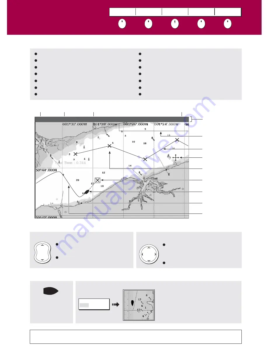
How do I move around the chart?

What can I use the chart for?

Chart

range

Chart

orientation

Motion

mode

Chart

view

Chart boundary

Status bar

Cursor

Route

Waypoint

Current position

Track

Cartographic object

Active waypoint

Find where you are.
Interpret your surroundings.
Place waypoints at specific locations.
Navigate to a specific point.
Monitor where you are going.
Record where you have been.
Measure the distance between two points.

Moves cursor.  When cursor reaches 
window edge, chart pans to a 
different area.

Press and hold to pan larger areas.

Press 

RANGE

 (OUT) to see a larger 

area of the chart.

Press 

RANGE

 (IN) to see a smaller 

area in more detail.

To change the scale:

To pan the chart:

Build and follow routes.
Manage and edit routes and tracks.
Distinguish between fixed & moving objects
(radar overlay).
View photographs of ports and marinas.
View information normally contained in an almanac. 
Display an aerial photo overlay. 

What can I see?

Understanding the chart

Card 5

FIND

SHIP   CURSOR

GOTO

ROUTES

TRACKS

PRESENTATION

How do I find where I am on the chart?

If you cannot find your boat symbol :

The boat symbol 
indicates your 
position.  

FIND

SHIP     CURSOR   

The screen automatically pans to your 
boat's position and re-activiates the motion 
mode (see below - 'How do I change how 
my boat moves on the chart').

?

More information...

Содержание Marine RADAR

Страница 1: ...nding the radar Avoiding a collision Using MARPA AIS Card 13 Card 14 Card 15 Card 16 Basic Navigation Working with waypoints How do I get to a point Card 11 Card 12 What can I see Understanding the ch...

Страница 2: ...our boat s position Press and hold to place a Man Overboard MOB marker at your current position Press and hold again to exit MOB RANGE Press to change the display scale so that a smaller or larger are...

Страница 3: ...ghlight the next option If a key displays a single value or a slider above use the rotary control to adjust Within the text of this document they are written in capitals e g SORT LIST Buttons Soft key...

Страница 4: ...To customise EDIT PAGE SET Follow on screen instructions Or PAGE OK PAGE ACTIVE SOFT KEY ACTIVE The applications are shown using a combination of page sets pages and windows There are five page sets e...

Страница 5: ...t CF CARD REMOVAL The system will now complete its checks When instructed to do so open the chart card door and remove the card Firmly click the chart door shut and press OK twice with the unit powere...

Страница 6: ...edge chart pans to a different area Press and hold to pan larger areas Press RANGE OUT to see a larger area of the chart Press RANGE IN to see a smaller area in more detail To change the scale To pan...

Страница 7: ...d in conjunction with motion mode see below to control how your boat and chart relate to one another and how they are displayed on screen The default mode is North Up N UP This displays your chart wit...

Страница 8: ...r OBJECT INFO MILE POINT Ebb Flood Ebb Flood Position 300 06 700N 840 12 700W 05 41AM 187 0 01 08AM 358 0 06 17AM 0 0 11 30AM 358 0 0 5kt 0 2kt 0 0kt 0 2kt Current information displayed Graph page dis...

Страница 9: ...INFO RAINBOW MARINA Photos Position 290 58 147N 0930 52 215W Book5 Chp5 Pilot Book OBJECT INFO RAINBOW MARINA Photos Pilot Book Position 290 58 147N 0930 52 215W Highlight required book chapter Selec...

Страница 10: ...n Status bar To enhance objects and make it easier to see their shape and position To show hide pre set cartographic features Press RANGE OUT to see a larger area of the chart Press RANGE IN to see a...

Страница 11: ...ew from above your boat What can I see Using the 3D chart Card 10 How do I find where I am on the 3D chart If you cannot see your boat symbol Synchronize 3D chart with 2D chart D8736_2 Your position T...

Страница 12: ...u regularly back up your waypoints by archiving them to a CompactFlash card Waypoints can also be transferred to another NMEA compatible instrument Networked systems If you have networked two or more...

Страница 13: ...oints on screen NORTH POINT KNOLL Target waypoint highlighted COWES Remaining legs of route PLACE WAYPOINT PLACE WAYPOINT Course from start point to target waypoint A route is made up of a series of w...

Страница 14: ...make a nearby small object may appear the same size on the screen as a distant large object However with experience the approximate size of different objects can be determined by the relative size an...

Страница 15: ...or re sized to avoid inappropriate alarms Sector Zone SHM Circular Zone SHM IMPORTANT A guard zone How can the radar help me avoid a collision You can set up your E Series Display to sound an alarm wh...

Страница 16: ...nd provides continuous and rapid situation evaluation MARPA tracks the selected targets and calculates target bearing range true speed course Closest Point of Approach CPA and Time to Closest Point of...

Страница 17: ...et alarm sounds and target flashes Activated target Target activated i e AIS vector displayed Vector line optional shows predicted distance travelled within given time Uncertain target Calculated CPA...

Страница 18: ...ress DATA CHART VECTORS COG HDG VECTORS Use the Course Deviation Indicator CDI With your display receiving accurate heading and position information you can monitor your course and accurately steer to...

Страница 19: ...LE PRESET 2 DUAL PRESET 3 SHALLOW PRESET 4 DEEP PRESENTATION F1 200 kHz Freq1 200KHz Auto Depth markers Target Bottom Bottom of transducer Frequency Frequency modes Target depth Bottom depth SINGLE Fr...

Страница 20: ...presets The system automatically adjusts the gain control to display the sharpest image If required you can select the gain level to suit your fishing mode To define the gain mode still further and t...

Страница 21: ...view images from a satellite TV video or DVD player or on board camera VIDEO 1 VIDEO 2 VIDEO 3 VIDEO 4 PRESENTATION The engine monitor application enables you to view data from up to three compatible...

Страница 22: ...p Navtex Messages To run the Sirius Weather application you will need to purchase an SR100 weather receiver and a subscription to Sirius weather Once connected the weather application superimposes his...

Страница 23: ...ary front red blue Trough brown Isobars grey 1012 1010 Dry line brown Or Surface pressure Hurricane Category 1 5 Tropical storm Tropical disturbance or tropical depression Storm Tracks symbols Note Hi...

Страница 24: ...ower key Select AUTOPILOT STANDBY to put the pilot in the autopilot into standby mode and take control of the helm manually AUTOPILOT STANDBY D10686_1 What are the Autopilot symbols Wind Vane mode Pow...

Страница 25: ...window allows you to select 4 user configurable preset modes Buoy Harbour Coastal Offshore They allow you to configure the Gain Color Gain Rain Sea Clutter settings to aid you in customising the displ...

Страница 26: ...not switched on or because a master has not been selected an alarm will sound and you will be prompted to set a master display How is the network controlled How do I change the master display D8487_2...

Отзывы: