


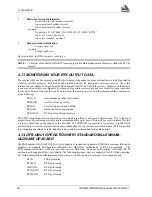


4
Operation
GPS/GLONASS Receiver User Manual Rev 1
41
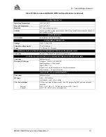
4.7.2 REAL-TIME KINEMATIC (RTK) DIFFERENTIAL POSITIONING
Available as an option on the MiLLennium-GLONASS GPSCard is R10 positioning which makes use of the
precise carrier-phase measurement. This implementation is similar to the RT20 software available on the standard
MiLLennium GPSCard but has been augmented to allow the use of GLONASS satellites. The position accuracy
achievable with RT10 positioning is substantially greater than PSR differential positioning. The data transfer rate
must be high enough to ensure that sufficient base station messages reach the rover station to keep prediction errors
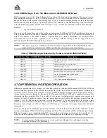
from growing too large. Table 4.2, Page 41 shows the base station prediction error to be expected from GPS
measurements.
Table 4.2 Latency-Induced Prediction Error
A new message type based on the RTCA format has been created to allow for combined GPS/GLONASS
operation. This is a proprietary message following the RTCA Type 7 subtype N protocol described in the RTCA
specifications for SCAT-1 approaches. The reference information for RTCA messaging is found in Appendix F of
the MiLLennium Commands Description Manual. The new RTCA message is significantly more efficient for L1
only operation. Along with the observation records, reference station information must also be sent in the form of
an RTCAREF message which follows RTCA Type 7 subtype N protocol as well. It is recommended that the
observation information be sent at 2 second intervals while the reference station information be sent at 10 second
intervals. The following commands for the reference and remote stations will initialize RTK operation.
Time since last base station observation
Typical base station prediction error (CEP) rate
0-2 seconds
1 cm/sec
2-7 seconds
2 cm/sec
7-30 seconds
5 cm/sec
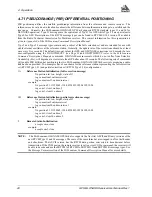
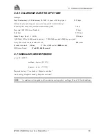
Table 4.3 RT10 Convergence Summary
a
a.
For 12 or more satellites above the mask where the RTK mask angle ranges from 11
°
to 14
°
as
the baseline goes from 0 to 15 km. Above 15 km it is 14
°
.
Tracking Time
(sec)
S/K
b
b. K = Kinematic (during initial ambiguity resolution)
S = Static (during initial ambiguity resolution)
Data Delay
(sec)
Distance (km)
Accuracy (cm)
(CEP)
1 to 280
S
0
1
100 to 18
280 to 600
S
0
1
18 to 10
600 to 3000
S
0
1
10 to 5
over 3000
S
0
1
5 or less
c
c.
The accuracy specifications refer to the PRTKA/B logs which include about 3 cm prediction
error. RTKA/B logs are more accurate but have more latency associated with them.
1 to 600
K
0
1
100 to 12
600 to 3000
K
0
1
12 to 5
over 3000
K
0
1
5 or less
S/K
0 to 2
1
+1 per sec
S/K
2 to 7
1
+2 per sec
S/K
7 to 30
1
+5 per sec
S/K
30 to 60
1
+7 per sec
d
d. Between 30 and 60 seconds assumes pseudorange differential positioning. If Type 1
corrections have not been transmitted, the accuracy drops to single point mode after 30
seconds.
S/K
60 or more
1
Single Point
S/K
0
0 to 10
+0.5 per km
e
e.
For typical tropospheric and ionospheric errors.
S/K
0
10 to 20
+0.75 per km
e
S/K
0
20 to 50
+1.0 per km
e