Settings
75
© 2003 - 2013 ... Naviter d.o.o.
7.1.1
Scheme properties
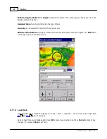
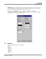
Scheme Properties dialog lets you change the color scheme for Vector map elevations and properties for
the topographic features of the map.
This is how you can change colors of the color scheme through this dialog:
. Click on an altitude bar on the left,
. Change it´s color through the "Color at X meters" combo box where X is the elevation you selected,
. Repeat this for about 4-6 different altitudes,
. Use the stylus to drag from one selected altitude to another,
. Press Spread,
. Repeat this for all of the intervals you have designed.
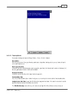
Object properties
allows you to change the zoom level and color for each of the topographic features
in the combo box.
Draw surface objects
will enable drawing woods and grass fields if newer Open Street Maps are
used.
Use Relative coloring
checkbox will allow you to color your present altitude in always the same color.
This feature is really a sort of graphical ground collision warning. To see how it works, select the
Содержание Oudie 3
Страница 1: ...2003 2013 Naviter d o o Oudie 3 Help Last modified 26 7 2013 for version 4 50...
Страница 5: ...Part I...
Страница 8: ...Part II...
Страница 11: ...Getting started 7 2003 2013 Naviter d o o 8 Reboot the Oudie one more time to complete the update...
Страница 30: ...Oudie 3 26 2003 2013 Naviter d o o...
Страница 35: ...Getting started 31 2003 2013 Naviter d o o...
Страница 39: ...Part III...
Страница 44: ...Oudie 3 40 2003 2013 Naviter d o o...
Страница 49: ...Part IV...
Страница 51: ...Part V...
Страница 53: ...Part VI...
Страница 77: ...Part VII...
Страница 110: ...Oudie 3 106 2003 2013 Naviter d o o See also Using vario Volume altitude 12 109...
Страница 111: ...Part VIII...
Страница 118: ...Oudie 3 114 2003 2013 Naviter d o o...
Страница 120: ...Oudie 3 116 2003 2013 Naviter d o o...
Страница 121: ...Part IX...
Страница 123: ...Part X...
Страница 126: ...Part XI...
Страница 128: ...Part XII...
Страница 130: ...Part XIII...

