background image

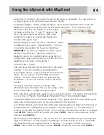
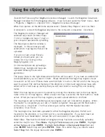
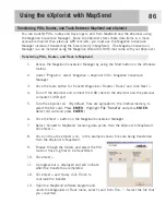
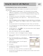
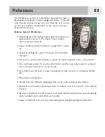
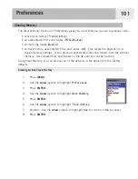
Setting the Light Timer

As has been mentioned before, the display backlight makes the display easier to read in low-
light situations, but it also is the largest drain on the batteries.  The Light Timer function
provides you with the selection of how long you want the backlight to remain on while no
buttons have been pressed. 

1.

Press 

MENU

.

2.

Use the 

Arrow

joystick to highlight 

Preferences

.

3.

Press 

ENTER

.

4.

Use the 

Arrow

joystick to highlight 

Pwr Management

.

5.

Press 

ENTER

.

6.

Use the 

Arrow

joystick to highlight the data field for 

Light Timer

.

7.

Press 

ENTER

.

8.

Use the 

Arrow

joystick to highlight the desired time interval or set to Timer 

Off

.

9.

Press 

ENTER

.

Preferences

98

Содержание eXplorist 500

Страница 1: ...ist 500 GPS Receiver Using the eXplorist 500 Starting Up Navigation Screens File Structure Points of Interest Routes Track Logs Advanced Features Magellan Geocache Manager Using MapSend Preferences Sp...

Страница 2: ...r damage the receiver and will void the warranty LICENSE AGREEMENT Thales Navigation grants you the purchaser the right to use the software supplied in and with Thales Navigation GPS products the SOFT...

Страница 3: ...Up 10 Turning the eXplorist On 10 Turning the eXplorist Off 10 Changing the Display Backlight Intensity 10 Using the eXplorist for the First Time 11 Conclusion 14 Navigation Screens 15 Accessing the...

Страница 4: ...ing Your Position Personalized 32 Making POIs for Locations Other Than Your Present Position 33 Marking a Position by Entering Coordinates 33 Marking a Position using the Map Cursor 34 Marking a Posit...

Страница 5: ...k Logs 58 Stopping and Resuming Active Track Logging 59 Starting a New Active Track Log 60 Saving an Active Track Log 61 Creating a BackTrack Route 62 Clearing the Active Track 63 Converting the Track...

Страница 6: ...l Computer 77 Magellan Geocache Manager 78 What is Geocaching 78 What is the Magellan Geocache Manager 78 How Do I Install the Magellan Geocache Manager 78 Using the Magellan Geocache Manager 79 Magel...

Страница 7: ...Timer 97 Setting the Light Timer 98 Personalizing the eXplorist 99 Selecting Languages 100 Clearing Memory 101 Clearing Active Track History 101 Clearing User Entered POIs and Routes 102 Clearing Rou...

Страница 8: ...lorist 500 GPS Receiver front Built in background map 8 MB High definition color display Preloaded points of interest Rugged design rubber protected 8 MB of usable memory Superior tracking with 14 par...

Страница 9: ...oomed out to 1700 mi 2700 km Also used to quickly step through the list of POIs when doing an alphabetical search MENU Brings up a menu with available options Options can be selected by using the arro...

Страница 10: ...ver 3 Battery Door Fastener Unscrew to open battery door to install batteries eXplorist 500 GPS Receiver back Battery Door Wrist Lanyard Strap Mounting Hole Connector for external power and connection...

Страница 11: ...y turn off when none of the buttons have been pressed and you are not moving for a selected time You can select from 5 10 30 or 60 minutes Use the display backlight sparingly The most severe drain on...

Страница 12: ...gnment tabs on the connector to make sure that the connector is installed properly It is recommended that you connect the eXplorist to external power using the external AC power adapter The other end...

Страница 13: ...from the satellites Do Point the antenna up toward the sky Maintain a clear view of the sky Don t Cover the antenna with your hand or other objects Point the antenna down Stand under trees or other h...

Страница 14: ...that your eXplorist automatically updates the route providing you with up to date information about getting to your destination GOTO routes are the simplest and most commonly used feature of your eXpl...

Страница 15: ...that represents the trail you have taken This is exactly what the eXplorist does It saves the computed positions as hidden points of interest and strings them together to represent your travels This i...

Страница 16: ...u to graphi cally see your position the route you are navigating the path you have trekked Track and points of interest icons There is a built in odometer so that you can log the length of your journe...

Страница 17: ...If you change your mind and decide to leave the eXplorist on just press the ESC button If you press the POWER button during this countdown period the eXplorist will immediately turn off Changing the...

Страница 18: ...en you agree to the warning statement press ENTER to continue Compute Initial Position For this operation it is best if you are outside and have a clear unobstructed view of the sky Without a clear vi...

Страница 19: ...nge the map scale so that you can see your present position better If the eXplorist is unable to compute your initial fix in a few minutes If the eXplorist determines that it is unable to track the sa...

Страница 20: ...h the list of months When you have entered the correct date press ENTER Accept Information The Done button is highlighted at the bottom of the display Review the information you entered if correct pre...

Страница 21: ...osition will be set to a null value If you have traveled with your eXplorist with it turned off the last position saved may be so far away that when the eXplorist begins looking for satellites the one...

Страница 22: ...y indicates your position and if moving points in the direction you are heading Press MARK to save your position Use the Arrow joystick to move the cursor The arrow cursor changes to a crosshair curso...

Страница 23: ...n has two modes that it can be in position or cursor In the Position mode the Map screen displays your position indicated by the arrow icon in the center of the map The arrow not only displays your po...

Страница 24: ...to move the cursor As soon as the joystick is moved a crosshair cursor is displayed and the bottom of the screen changes to provide information about the cursor position To exit the cursor mode press...

Страница 25: ...nformation 1 While viewing the Map screen press MENU 2 Use the Arrow joystick to highlight Customize page 3 Press ENTER 4 Use the Arrow joystick to highlight Customize Fields 5 Press ENTER 6 The title...

Страница 26: ...p of the map display to represent true north Course Up In course up the top of the map displays the direction to your destination When there is not an active route the top of the display indicates tru...

Страница 27: ...e displayed as yellow This is provided as an option to provide you with the ability to view the text and map details more easily depending on where you are navigating To change the primary usage 1 Whi...

Страница 28: ...he eXplorist doesn t save track points when you are traveling in a straight line and only a few as you make turns This saves memory and provides a track log that while slightly jagged is suitable for...

Страница 29: ...joystick to highlight Map Setup 3 Press ENTER 4 Push the Arrow joystick left or right to highlight the Display tab 5 Push the Arrow joystick up or down to highlight the item you want to toggle on or o...

Страница 30: ...rection you are heading when you are moving Compass Screen Overview The top of the screen the header bar displays the name of the destination if you have an active route Without an active route the de...

Страница 31: ...d To customize the map information 1 While viewing the Compass screen press MENU 2 Use the Arrow joystick to highlight Customize page 3 Press ENTER 4 The title bar for one of the fields is highlighted...

Страница 32: ...d in the Accuracy field when the eXplorist is using WAAS information to increase the accuracy of the position fix Date and time are shown automatically adjusted from time information supplied from the...

Страница 33: ...ant to reset the trip odometer to zero To reset the trip odometer 1 While viewing the Position screen press MENU 2 Use the Arrow joystick to highlight Reset Trip 3 Press ENTER 4 Use the Arrow joystick...

Страница 34: ...ition fix and the number of satellites being tracked is displayed A 2D Position Fix requires three satellites a 3D Position Fix requires four satellites or more Graphical indication of the location of...

Страница 35: ...file The Detail Maps and Geocaches folders are empty until you upload a detailed map from mapping software such as Magellan MapSend or geocache files from the Magellan Geocaching software The files f...

Страница 36: ...your POI files to be saved in Use the Arrow joystick to highlight New Folder and press ENTER Use the displayed keyboard to enter a name for the folder When the name is correct highlight OK and press E...

Страница 37: ...ss ENTER If you want you can now browse through the file structure to find the folder you want to save the track log in When you have selected the desired location highlight Save in here and press ENT...

Страница 38: ...create routes Marking Your Position The most common way of adding POIs to the database will be to mark your present position There are two levels of marking your position The first that will be descr...

Страница 39: ...nformation block at the top of the keypad 4b If the Name field is selected Use the Arrow joystick to select the character desired and press ENTER If you make a mistake highlight Back and press ENTER T...

Страница 40: ...ll have to go to Preferences and change the coordinate system used by your eXplorist 1 Press MARK 2 Use the Arrow joystick to highlight the Location field 3 Press ENTER 4 Depending on the coordinate s...

Страница 41: ...r method of marking a position while in the Cursor mode is to use the crosshair cursor to mark a map object road city etc 1 While viewing the Map screen use the Arrow joystick to put the eXplorist int...

Страница 42: ...POI When searching for a POI that you have entered you have two options to choose from nearest or alphabetical 1 Press MENU 2 Use the Arrow joystick to highlight Pts of Interest 3 Press ENTER 4 Use t...

Страница 43: ...the Arrow joystick in an up down motion to highlight Background Map 5 Use the Arrow joystick in a left right motion to select Nearest 6 Press ENTER 7 Use the Arrow joystick to select Position POIs ne...

Страница 44: ...oystick to highlight the category Cities Highways Airports Waterways or Parks for the POI 8 Press ENTER 9 Use the Arrow joystick and the ENTER button to enter the first few characters of the POI you a...

Страница 45: ...2 Press ENTER 13a If the Icon field is selected Use the Arrow joystick to select the icon desired and press ENTER To aid in your selection the type of icon selected is displayed in the information blo...

Страница 46: ...ll be displayed confirming the deletion 1 Press MENU 2 Use the Arrow joystick to highlight Pts of Interest 3 Press ENTER 4 Use the Arrow joystick up down to highlight My Pts of Interest 5 Use the Arro...

Страница 47: ...atically open the default file 8 Highlight the POI and press ENTER 9 Use the Arrow joystick to highlight View on Map 10 Press ENTER 11 The Map screen will be displayed in the Cursor mode The cursor wi...

Страница 48: ...Use the Arrow joystick to highlight the field you want to change 13 Press ENTER 14a If the Icon field is selected Use the Arrow joystick to select the icon desired and press ENTER To aid in your selec...

Страница 49: ...ght OK and press ENTER to continue 8 Use the Arrow joystick to highlight the POI to be viewed 9 Press ENTER 10 Use the Arrow joystick to highlight View 11 Press ENTER 12 The Map screen will be display...

Страница 50: ...creating a new POI 1 Press MENU 2 Use the Arrow joystick to highlight Pts of Interest 3 Press ENTER 4 Use the Arrow joystick up down to highlight My Pts of Interest 5 Use the Arrow joystick left right...

Страница 51: ...advantage of a multi leg route is that it can be saved in the eXplorist s memory to be activated and used over and over A third type of route is a backtrack route The creation of backtrack routes is...

Страница 52: ...creen a line will be drawn representing the GOTO route The Compass screen will change to display the name of the POI used as the destination in the screen header bar and an icon representing the desti...

Страница 53: ...oute Highlight Yes and press ENTER 5 Confirm that you want to create a GOTO from the current cursor position Highlight Yes If you highlight No and press ENTER the eXplorist assumes that you still want...

Страница 54: ...s of the map may have multiple map objects in the same location 5 Press ENTER 6 If a GOTO is active you will be asked to deactivate it and create a new GOTO route Highlight Yes and press ENTER 7 The e...

Страница 55: ...1 to Bait Bait to Fish Features of a multi leg route Multi leg routes can be saved in internal memory or to an SD card Multi leg routes remain active even after the eXplorist has been turned off Mult...

Страница 56: ...n the route list Inserting Use the Arrow joystick to highlight the POI that you want to insert a new leg before Press MENU highlight Insert POI and press ENTER Search the POI database for the new POI...

Страница 57: ...ually 1 Press MENU 2 Use the Arrow joystick to highlight Routes 3 Press ENTER 4 Locate the file that contains the route you want to activate or deactivate The eXplorist will automatically open the def...

Страница 58: ...routes you would follow the instructions below and tell the eXplorist to set the next leg to the ranger station The route would be recomputed eliminating the navigation instructions to go to the stone...

Страница 59: ...route Inserting Use the Arrow joystick to highlight the POI that you want to a new leg inserted in front of Press MENU highlight Insert POI and press ENTER Search the POI database for the new POI The...

Страница 60: ...nger Swim would now be Swim Ranger Marker Bridge Camp 1 Press MENU 2 Use the Arrow joystick to highlight Routes 3 Press ENTER 4 Locate the file that contains the route you want to reverse The eXploris...

Страница 61: ...Arrow joystick to highlight Routes 3 Press ENTER 4 Locate the file that contains the route you want to delete The eXplorist will automatically open the default file 5 With the file highlighted press E...

Страница 62: ...ontains the route you want to move The eXplorist will automatically open the default file 5 Press ENTER 6 Highlight the name of the route 7 Press ENTER 8 Use the Arrow joystick to highlight Move Route...

Страница 63: ...ht Routes 3 Press ENTER 4 Locate the file that contains the route you want to copy The eXplorist will automatically open the default file 5 Press ENTER 6 Highlight the name of the route 7 Press ENTER...

Страница 64: ...he route Locate the file that contains the route you want to copy 5 Press ENTER 6 Highlight the name of the route 7 Press ENTER 8 Use the Arrow joystick to highlight View on Map 9 Press ENTER The rout...

Страница 65: ...same path you just took You will find many other additional uses for track logs once you feel comfortable with them Track Logs As mentioned above track logs are records of your travels using electroni...

Страница 66: ...ing recorded Resume Logging appears only when the active track is not being recorded 7 Press ENTER Note The eXplorist will fill in a straight line from the point where track logging was stopped to the...

Страница 67: ...U 2 Use the Arrow joystick to highlight Track Log 3 Press ENTER 4 Use the Arrow joystick to highlight Active Track 5 Press ENTER 6 Highlight Stop Logging If Resume Logging is displayed the Track Log h...

Страница 68: ...o highlight Track Log 3 Press ENTER 4 Use the Arrow joystick to highlight Active Track 5 Press ENTER 6 Highlight Save 7 Press ENTER If there are not enough track points to save an alert will be displa...

Страница 69: ...last viewed navigation screen will be displayed The eXplorist will now begin computing the navigation information needed to guide you back to your starting point NOTE When you have an active BackTrack...

Страница 70: ...d clear the active track before beginning your journey If you do not the other functions will still work but you will probably have a lot more track log information than you want 1 Press MENU 2 Use th...

Страница 71: ...ystick to highlight Track Log 3 Press ENTER 4 Use the Arrow joystick to highlight Active Track or any track log you have previously saved 5 Press ENTER 6 Highlight Convert to Route 7 Press ENTER 8 Use...

Страница 72: ...rrow joystick to highlight Track Log 3 Press ENTER 4 Use the Arrow joystick to highlight Active Track or any track log you have previously saved 5 Press ENTER 6 Highlight View on Map 7 Press ENTER The...

Страница 73: ...eviously saved 5 Press ENTER 6 Highlight Follow Track 7 Press ENTER 8 Track logging will be turned off alert status Press ENTER The last viewed navigation screen is displayed with the track log select...

Страница 74: ...longer needed 1 Press MENU 2 Use the Arrow joystick to highlight Track Log 3 Press ENTER 4 Use the Arrow joystick to highlight any track log you have previously saved 5 Press ENTER 6 Highlight Delete...

Страница 75: ...MENU 2 Use the Arrow joystick to highlight Track Log 3 Press ENTER 4 Use the Arrow joystick to highlight any track log you have previously saved 5 Press ENTER 6 Highlight Move Track 7 Press ENTER 8 L...

Страница 76: ...R 4 Use the Arrow joystick to highlight any track log you have previously saved 5 Press ENTER 6 Highlight Copy Track 7 Press ENTER 8 Locate the location where you want the track log stored 9 Highlight...

Страница 77: ...o display a vertical profile of routes you have saved Simulate Provides you a tool for putting the eXplorist into a simulate mode With the simulator turned on the eXplorist will operate as if it was m...

Страница 78: ...n you have defined Deleting All POIs from the Area Calculation List 1 While viewing the Area Calculation screen press MENU 2 Highlight Delete All Points 3 Press ENTER 4 All of the POIs in the list are...

Страница 79: ...ght Fish Hunt 5 Press ENTER 6 The Fish Hunt screen is displayed with the position and date set to your present position and today s date Changing the Position 1 With the Fish Hunt screen displayed hig...

Страница 80: ...joystick to highlight Sun Moon 5 Press ENTER 6 The Sun Moon screen is displayed with the position and date set to your present position and today s date Changing the Position 1 With the Sun Moon scre...

Страница 81: ...e Arrow joystick to highlight Adv Features 3 Press ENTER 4 Use the Arrow joystick to highlight Vertical Profile 5 Press ENTER 6 Highlight Track History When a MapSend Topograhic detailed map has been...

Страница 82: ...edefined route 7 If you have an active track log being recorded the simulator will need to delete this track A warning is displayed that your track will be deleted Highlight Yes and press ENTER to era...

Страница 83: ...that the eXplorist is in the file transfer mode Changing Modes When you are connected to a personal computer you have three modes that the eXplorist can be in File Transfer mode allows you to transfe...

Страница 84: ...e previous instructions to connect the eXplorist to your personal computer 2 If the USB File Transfer screen is not being displayed follow the above instructions to select the File Transfer mode 3 To...

Страница 85: ...rce of geocache points visit GEOCACHING at www geocaching com What is the Magellan Geocache Manager The Magellan Geocache Manager is a software application that runs in Windows on your personal comput...

Страница 86: ...agellan eXplorist 500 Magellan Geocache Manager 3 The Magellan Geocache Manager will open and an empty list of geocache points is displayed 4 The common tools are displayed as icons at the top of the...

Страница 87: ...ou want to save the opened database under a new name Add Insert Adds a new geocaching point to the list Geocaching points added to the list using the Add icon require that you input the information fo...

Страница 88: ...e to add downloaded files to this list To do this you need to follow these instructions 1 Click the Open Icon 2 Using the Windows Open File window select the downloaded file you want to add 3 At the b...

Страница 89: ...ss ENTER 3 Select the files to be uploaded If no files are selected it is assumed that you want to upload the entire list Tips on selecting files To select a single geocache point click on the name To...

Страница 90: ...preloaded map regions on SD cards or as web downloads Plug and play in the eXplorist but are limited in geographic area Please note that not all MapSend products will presently work with the eXploris...

Страница 91: ...onnect buttons Once the serial number has been entered click Next You will be asked to confirm the serial number The Ready to Update window is displayed with information about the region that you are...

Страница 92: ...card for the map you want to upload The internal memory of the eXplorist is limited and large detail maps with either not fit or will take up memory that you will need later for saving POIs and creati...

Страница 93: ...ick Next 4 Turn off the eXplorist and connect the USB cable to the eXplorist and the personal computer s USB port 5 Turn the eXplorist on By default files are uploaded to the internal memory to select...

Страница 94: ...Convert Waypoints Routes Tracks and click Next 7 Turn off the eXplorist and connect the USB cable to the eXplorist and the personal computer s USB port 8 Turn the eXplorist on Press ENTER From the Co...

Страница 95: ...nformation displayed A means to set the north reference used to be either magnetic north or True North The coordinate system for position information and the map datum used to compute the coordinate i...

Страница 96: ...here it was turned off and will begin looking for the satellites that it thinks are overhead If the satellites are not there the eXplorist begins polling the skies trying to determine which satellites...

Страница 97: ...e Arrow joystick to enter the current time Push the Arrow joystick up or down to change the value and left or right to move the cursor Note Time is one of the first pieces of information transmitted b...

Страница 98: ...t for POI s routes and geocache files 1 Press MENU 2 Use the Arrow joystick to highlight Preferences 3 Press ENTER 4 Use the Arrow joystick to highlight Active Setup 5 Press ENTER 6 Use the Arrow joys...

Страница 99: ...rmation additional POIs and if using on of the MapSend topographic software packages topo details You can use Active Setup to select the detail map you want to use if you have one saved 1 Press MENU 2...

Страница 100: ...ta in Miles Yd MPH Miles Ft MPH NM Ft Knots NM M Knots or KM KPH 1 Press MENU 2 Use the Arrow joystick to highlight Preferences 3 Press ENTER 4 Use the Arrow joystick to highlight Map Units 5 Press EN...

Страница 101: ...Preferences 3 Press ENTER 4 Use the Arrow joystick to highlight Map Units 5 Press ENTER 6 Use the Arrow joystick to highlight the data field for North Reference 7 Press ENTER 8 Use the Arrow joystick...

Страница 102: ...Preferences 3 Press ENTER 4 Use the Arrow joystick to highlight Map Units 5 Press ENTER 6 Use the Arrow joystick to highlight the data field for Coord System 7 Press ENTER 8 Use the Arrow joystick to...

Страница 103: ...hould be used when you are unsure as to what datum to select 1 Press MENU 2 Use the Arrow joystick to highlight Preferences 3 Press ENTER 4 Use the Arrow joystick to highlight Map Units 5 Press ENTER...

Страница 104: ...is will prevent the batteries from running out if you accidentally leave the eXplorist on 1 Press MENU 2 Use the Arrow joystick to highlight Preferences 3 Press ENTER 4 Use the Arrow joystick to highl...

Страница 105: ...lection of how long you want the backlight to remain on while no buttons have been pressed 1 Press MENU 2 Use the Arrow joystick to highlight Preferences 3 Press ENTER 4 Use the Arrow joystick to high...

Страница 106: ...Arrow joystick to highlight the data field for Name 7 Press ENTER 8 Use the Arrow joystick and ENTER button to input your name 9 Use the Arrow joystick to highlight OK when the name is entered 10 Pre...

Страница 107: ...Dutch Suomi Finnish Espa ol Spanish Italiano Italian Portugu s Portuguese Svenska Swedish and Norsk Norwegian Selecting the Language for Your eXplorist 1 Press MENU 2 Use the Arrow joystick to highli...

Страница 108: ...er created files and folders from the internal memory User created files and folders on the SD card will not be touched Using Clear Memory you can also set all of the defaults in the eXplorist to the...

Страница 109: ...ck to highlight Yes to confirm or No to cancel 8 Press ENTER Clearing Routes This will clear all of the routes you have entered that are saved in the default files used internally to the eXplorist Rou...

Страница 110: ...t Preferences 3 Press ENTER 4 Use the Arrow joystick to highlight Clear Memory 5 Press ENTER 6 Use the Arrow joystick to highlight All 7 Confirm Use the Arrow joystick to highlight Yes to confirm or N...

Страница 111: ...mph the alarm will sound slighting before the 250 foot mark Off Course When a route is active the eXplorist computes when you have moved left or right of the plotted route You can set a distance left...

Страница 112: ...Preferences 3 Press ENTER 4 Use the Arrow joystick to highlight Alarms Beeper 5 Press ENTER 6 Use the Arrow joystick to highlight the alarm field that you want to turn off or set 7 Press ENTER 8 Selec...

Страница 113: ...t a format that the time will be displayed in If the format you are presently using is the format you want to keep you still need to verify the format before you can set the clock 1 Press MENU 2 Use t...

Страница 114: ...row joystick to highlight the Region field 7 Press ENTER 8 Select United States European Union Custom or Disable 9 Press ENTER 10 If Custom You need to enter the information about the start and end da...

Страница 115: ...MS steady state Limits Speed 951 MPH 1530 5 km h Altitude 60 000 ft 18 600 meters Physical Size 4 6 x 2 1 x 1 3 h x w x d 11 7 cm x 5 3 cm x 3 3 cm Weight 4 ounces 110 grams with battery installed Dis...

Страница 116: ...cluding spaces Built in included with background map Categories Cities highways airports waterways and parks Navigation Screens Map Includes background map and 2 data fields customizable Compass Inclu...

Страница 117: ...ter wherever your adventure takes you Part number 702209 Bike Mounting Mount your Magellan eXplorist on your bicycle snowmobile or motorcycle for convenient operation and viewing The easy to install m...

Страница 118: ...hone Our technical support phone representatives are available Monday through Friday 6 00 a m to 5 00 p m P S T P D T Telephone 800 707 9971 or 1 909 394 5000 Outside North America You may also reach...

Страница 119: ...supportfr thalesnavigation com free of charge phone access available from Eire UK Portugal Spain France Belgium The Netherlands Germany Austria Switzerland Norway Sweden Denmark and Finland For Magell...

Отзывы: