


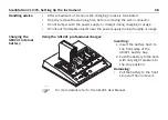


48
ScanStation C10/C5, Setting Up the Instrument
2.4
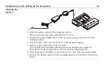
Instrument Height
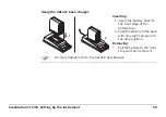
Measure instru-
ment height
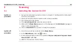
To get an accurate height measurement use the GHM008 instrument height meter in
conjunction with the GHT196 distance holder which are both included with the
scanner.
1. Place tripod centrally over the ground
point, level instrument.
2. Click GHT196 distance holder to tribrach.
It must "snap" onto the cover over an
adjusting screw.
3. Unfold measuring tongue, pull out tape
measure a little.
4. Insert GHM008 instrument height meter
in the distance holder and attach.
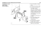
5. Swivel measure in the direction of the
ground point, pull out until the tip of the
measuring tongue touches the point on
the ground, keep under tension and do
not allow to sag, clamp if necessary.
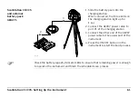
6. Read height of the instrument (ground -
tilt axis) in the reading window at the red
marking (in the example 1.627 m).
6
5
2
1.627
C10_040
Содержание ScanStation C10
Страница 1: ...Leica ScanStation C10 C5 User Manual Version 5 0 English ...
Страница 41: ...ScanStation C10 C5 Description of the System 41 ...
Страница 85: ...ScanStation C10 C5 Troubleshooting 85 ...
Страница 97: ...ScanStation C10 C5 Care and Transport 97 ...
Страница 118: ...118 ScanStation C10 C5 Safety Directions a Laser beam b Exit for laser beam b C10_032 a ...
Страница 126: ...126 ScanStation C10 C5 Safety Directions Labelling GEB271 ...
Страница 127: ...ScanStation C10 C5 Safety Directions 127 Labelling GKL271 ...
Страница 149: ...ScanStation C10 C5 Microsoft End User License Agreement EULA 149 ...
Страница 152: ......


