background image

GPSMAP 640 Owner’s Manual

Marine Mode: Using XM WX Weather and Audio

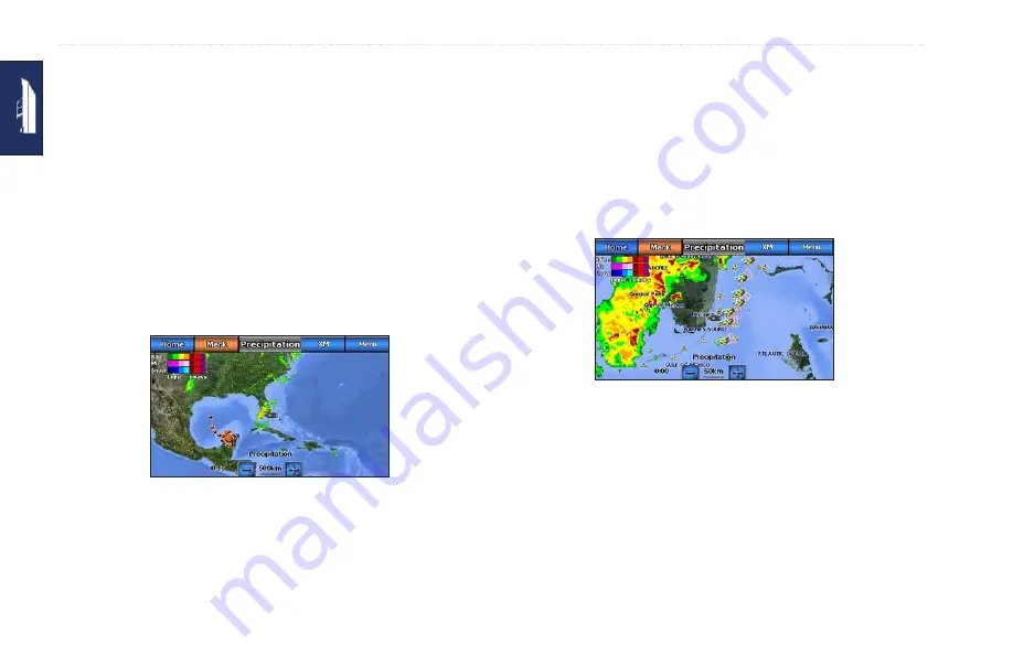
Viewing NEXRAD Radar Information

NEXRAD shows precipitation, from very light rain and snow 

to strong thunderstorms, in varying shades and colors. To turn 

the NEXRAD loop on from the Home screen, touch 

Weather

 > 

Weather Setup

 > 

NeXRaD Loop

 > 

on

.

In the lower-left corner of the screen is a time stamp. The Time 

Stamp indicates the elapsed time since the National Weather 

Service last updated the information.
To view the weather legend from the Home screen, touch 

Weather


Weather Setup

 > 

Legend

 > 

Show

. NEXRAD is shown 

independently or with a variety of other weather information.

NEXRAD Weather Overlay

To turn cloud cover on or off, touch 

Menu

 > 

Cloud Cover

 > 

Hide


or 

Show

.

Understanding Storm Cell Information

The storm cells show storms as well as the projected path of a 

storm in the immediate future. 
The direction of the red cone indicates the projected path of the 

storm cell. The red bars that appear in the cone indicate where 

the storm will most likely be in the future. Each bar represents 15 

minutes.

Storm Cells

Understanding Lightning Information

Lightning strikes are represented by lightning bolt icons. Lightning 

appears on the map if strikes were detected within the last seven 

minutes. The ground-based lightning detection network only 

detects cloud-to-ground lightning.

Содержание GPSMAP 640

Страница 1: ...GPSMAP 640 owner s manual ...

Страница 2: ...hereto provided that such electronic or printed copy of this manual must contain the complete text of this copyright notice and provided further that any unauthorized commercial distribution of this manual or any revision hereto is strictly prohibited Information in this document is subject to change without notice Garmin reserves the right to change or improve its products and to make changes in ...

Страница 3: ...elp us better support you by completing our online registration today Go to http my garmin com Keep the original sales receipt or a photocopy in a safe place Contact Garmin Contact Garmin Product Support if you have any questions while using your GPSMAP 640 In the USA go to www garmin com support or contact Garmin USA by phone at 913 397 8200 or 800 800 1020 In the UK contact Garmin Europe Ltd by ...

Страница 4: ...th a soft clean lint free cloth Use water isopropyl alcohol or eyeglass cleaner if needed Apply the liquid to the cloth and then gently wipe the touchscreen Protecting Your GPSMAP 640 Do not store the GPSMAP 640 where prolonged exposure to extreme temperatures can occur because it can cause permanent damage Although a PDA stylus can be used to operate the touchscreen never attempt this while opera...

Страница 5: ...aved Location 7 Stopping Navigation 7 Adjusting the Volume 7 Adjusting the Backlight 7 Marine Mode Using Charts 8 Using the Navigation Chart 8 Interacting With Objects on the Navigation Chart 9 Accessing Additional Object or Chart Information 9 Using Perspective 3D 10 Using BlueChart g2 Vision 11 Using Mariner s Eye 3D 11 Using Fish Eye 3D 12 Using Fishing Charts 12 Enabling High Resolution Satell...

Страница 6: ...uring Communications Settings 35 Configuring Alarm Settings 36 Configuring My Boat 37 Configuring Other Vessels 37 Configuring Navigation Settings 38 Configuring XM Radio 38 Configuring Navigation Chart Options 39 Configuring Perspective 3D Options and Mariner s Eye 3D Options 43 Fish Eye 3D Settings 44 Fishing Chart Settings 44 Configuring the Active Track Options 45 Configuring the Numbers Scree...

Страница 7: ...urce 63 Deleting Automotive Files 64 Automotive Mode Using the Tools 65 Settings 65 Where Am I 65 Picture Viewer 65 My Data 65 Automotive Mode Advanced Configuration 66 Changing the System Settings 66 Changing the Navigation Settings 66 Adjusting the Display Settings 66 Adjusting the Volume 67 Adjusting the Backlight 67 Updating the Time Settings 67 Setting the Languages 67 Changing the Map Settin...

Страница 8: ...arging Your GPSMAP 640 73 Changing the Fuse on the Automotive Mount 73 Additional Maps 73 About GPS Satellite Signals 73 Extras and Optional Accessories 74 Specifications 74 Declaration of Conformity 75 Software License Agreement 75 Troubleshooting 75 Messages and Alarms Marine Mode 76 Index 81 ...

Страница 9: ...ter or to an optional GXM 40 XM antenna GPSMAP 640 only Identifying the GPSMAP 640 Mounting Bracket Features Marine Mounting Bracket Automotive Mounting Bracket Bail mount adapter connect the marine mounting bracket to the marine bail mount Ball socket adapter connect the mounting bracket adapter to a compatible automotive dash mount Audio line out connect the unit to an audio output source with a...

Страница 10: ...he GPSMAP 600 Series Flush Mount Kit at www garmin com To install the automotive mounting bracket in your car 1 Place the automotive mount base on your dash and press down on each of the four sides The base bends and conforms to your dashboard 2 Snap the mounting bracket onto the automotive mount arm 3 Plug the vehicle power cable into a power outlet in your vehicle TIP If the bottom surface of th...

Страница 11: ...a power source it will continue to charge the battery Removing and Inserting the Battery Pack notice This product contains a lithium ion battery To prevent damage remove the unit from the vehicle or boat when exiting or store it out of direct sunlight To remove the battery pack 1 Remove the GPSMAP 640 from the mounting bracket 2 On the back of the device lift up the battery locking ring and turn i...

Страница 12: ...GPSMAP 640 the SD card slot is located under the battery To insert an SD card 1 Remove the battery pack The SD card slot is in the bottom of the battery compartment on the opposite side from the battery contacts 2 Place an SD card into the opening with the label showing with the SD card contacts facing away from the battery contacts 3 Slide the SD card into the SD card slot and press until it clic...

Страница 13: ... the Power key Step 3 Acquire Satellites 1 Go outdoors to an open area away from tall buildings and trees 2 Turn on your GPSMAP 640 Acquiring satellite signals can take a few minutes The bars indicate satellite strength When at least one of the bars is green your GPSMAP 640 has acquired satellite signals Now you can select a destination and navigate to it Step 4 Use Your GPSMAP 640 Marine Mode Hom...

Страница 14: ...es while following the line to your destination Tips In addition to navigating directly to your destination you can create a route or allow the device to create a route For advanced navigation options see page 14 You can also use the Compass screen to actively navigate to your destination by following a pointer on a compass See page 25 for more information Navigating Directly to a Destination Navi...

Страница 15: ... Stop Navigation NOTE You can also stop navigation from the Where To screen Adjusting the Volume 1 From any screen press and quickly release the Power key 2 Touch Volume 3 Touch and drag the volume slider bar left to decrease the volume and right to increase the volume The box to the right of the volume slider bar shows the volume level as a percentage To mute the volume touch the box to the right...

Страница 16: ...lays a view from above and behind your boat for a visual navigation aid page 10 Fishing Chart removes navigational data from the chart and enhances bottom contours for depth recognition page 12 Fish Eye 3D provides an underwater view that visually represents the sea floor according to information on the chart page 12 NOTE Mariner s Eye 3D Fishing Charts and Fish Eye 3D views are only available whe...

Страница 17: ...14 Create Waypoint marks a waypoint at the location of the pointer page 22 Information view additional information about an object or an area of the chart Measure Distance view the distance and bearing of the object from your current location The information appears in a window on the upper left corner of the screen Touch Set Reference to measure from a location other than your current location NO...

Страница 18: ...ch a camera icon A standard camera icon indicates an overhead photo A camera icon with a cone indicates a perspective photo The photo was taken from the location of the camera pointed in the direction of the cone 2 Touch Aerial Photo Using Perspective 3D Perspective 3D provides a view from above and behind the boat according to your heading and provides a visual navigation aid When navigating you ...

Страница 19: ...art Detailed Roads and POI data displays roads restaurants and other points of interest POIs along the shore Auto Guidance uses specified safe depth safe height and chart data to suggest the best passage to your destination Using Mariner s Eye 3D When using a BlueChart g2 Vision SD card you can view the Mariner s Eye 3D screen The Mariner s Eye 3D screen is similar to the Perspective 3D screen pag...

Страница 20: ...etailed bottom contours and depth soundings on the chart There are no navigation aids such as buoys and lights on the fishing chart The fishing chart uses highly detailed bathymetric data contained on a preprogrammed BlueChart g2 Vision SD card and is best for offshore deep sea fishing Navigation Chart Fishing Chart To access the Fishing chart screen from the Home screen touch Charts Fishing Chart...

Страница 21: ...ater with photos overlaying the land Photo Map Blend photos overlay both the water and the land at a specified opacity The higher you set the percentage the more the satellite photos cover both water and land When enabled the high resolution satellite images are only present at lower zoom levels If you cannot see the high resolution images in your BlueChart g2 Vision region zoom in by touching or ...

Страница 22: ...ter icon indicates the destination on the chart Tip Touch and to zoom in and out Touch anywhere on the chart and drag to pan the map For more information on using charts see page 8 Choosing a Destination Using Where To 1 From the Home screen touch Where To 2 Touch a category Waypoints view a list of locations you marked previously page 20 Routes view a list of routes you saved previously page 20 T...

Страница 23: ...t move even when you are off course Caution When using Go To a direct course and a corrected course may pass over land or shallow water Use visual sightings and steer to avoid land shallow water and other dangerous objects In the center of the magenta line is a thinner purple line that represents the corrected course from your current location to the end point The corrected course line is dynamic ...

Страница 24: ...40 Creating a Route Route To 1 When the pointer icon is on the location you want to navigate to or you have selected a destination using Where To touch Navigate To Route To 2 Touch the location where you want to make the last turn toward your destination Adding the Last Turn 3 Touch Add Turn 4 To add an additional turn touch another location where you want to make a turn working backward from the ...

Страница 25: ...ine appears between the start point and the first turning point then continues on to each subsequent turning point This magenta and purple line represents the route leg from turning point to turning point and does not move even when you are off course Caution Even when you carefully create a route legs may pass over land or shallow water Use visual sightings and steer to avoid land shallow water a...

Страница 26: ...enta and purple line route leg Following a Route on the Navigation Chart Route leg Course to Steer Start point Route turn Following a Route on the Mariner s Eye 3D Screen Route leg Course to Steer Route turn NOTE When following a route important navigation information appears in a data bar along the top of the chart To adjust the settings of the data bar see page 40 Setting an Automatic Course Gui...

Страница 27: ...reen After you create an automatic course using Guide To a magenta line appears The magenta line represents the suggested passage between the start point and the end point and does not move even when you are off course 1 After you set an automatic course using Guide To from the Home screen touch Charts and then touch Navigation Chart Perspective 3D or Mariner s Eye 3D 2 Follow the magenta line fro...

Страница 28: ...r and navigate to them 1 From the Home screen touch Where To Waypoints A list of saved waypoints appears sorted by distance including the distance and bearing to each 2 Touch the waypoint you want to navigate to 3 Touch Navigate To to set the selected waypoint as a navigation destination See page 14 for information about navigating to a destination Searching for Saved Routes 1 From the Home screen...

Страница 29: ...ch by Name 2 Use the on screen keyboard to type the name or part of the name of the marine service the waypoint the saved route or the saved track you want to find and touch Done 3 A list of results appears Touch the item you want to navigate to Each entry is marked by an icon to help identify which category it belongs to marine service icon default waypoint icon this icon can be changed using the...

Страница 30: ...oint 2 Touch Yes to begin navigating to the MOB waypoint To mark an MOB waypoint from any other screen 1 Touch Mark in the top left corner of any screen except the Home screen This immediately marks your current position as a waypoint 2 Touch Man Overboard This designates the waypoint as an MOB waypoint and begins navigation automatically Marking a Waypoint at Your Current Location 1 Touch Mark on...

Страница 31: ...Chart or Enter Coordinates 5 If entering coordinates use the on screen keyboard to enter the new coordinates for the waypoint If using the chart touch the new location and then touch Move Waypoint Deleting a Waypoint or MOB 1 From the Home screen touch Information User Data Waypoints List 2 Touch the name of the waypoint or the MOB you want to delete 3 Touch Delete and then touch OK to confirm tha...

Страница 32: ...acks Follow Active Track 2 Either touch the time the current track began recording or touch Entire Log Navigating a Saved Track 1 From the Home screen touch Where To Tracks 2 Touch the name of the saved track you want to navigate 3 Touch Follow Track 4 Touch Forward or Backward to follow the track in the direction you prefer NOTE You can also navigate a saved track from the saved tracks list Infor...

Страница 33: ...ur current heading and the corrected course is called the Course to Steer and is shaded orange on the compass Caution Just as on the Navigation chart a direct course and a corrected course may pass over land or shallow water Use visual sightings and steer to avoid land shallow water and other dangerous objects Current heading Course to Steer Corrected course Following a Direct Course on the Compas...

Страница 34: ...oard Numbers For more information on configuring the Numbers screen see page 45 Using the Trip Screen The Trip screen provides helpful statistics about your trip To view the Trip screen from the Home screen touch Dashboard Trip Resetting Trip Screen Information 1 From the Trip screen touch Menu 2 Touch an item to reset that category of information on the Trip screen or touch Reset All ...

Страница 35: ...Station Graph Touch any point on the tide graph to view the tide level at a different time You can also drag your finger along the graph to scroll Touch Nearby Stations to view other tide stations close to your position Touch Change Date Manual to view tide information for a different date Touch Show Report to view the Tide Report for the selected station Viewing Current Information To view curren...

Страница 36: ...n of the sun and moon To view celestial information from the Home screen touch Information Celestial Touch Change Date Manual to view information for a different date Touch the left and right arrows to view celestial information for a different time on that date Touch Moon Phase to view the moon phase at the specified date and time Touch Show Skyview to return to the celestial sky view Touch Next ...

Страница 37: ...Select an option Save To Card save waypoints routes and tracks to the SD card Merge From Card transfer data from the SD card to the unit and combine it with existing user data Replace From Card overwrite items on your device Copy Built In Map copy the pre loaded basemap on the GPSMAP 640 to and SD card for use with compatible Garmin PC software products Backing up Marine Data to a PC 1 Insert an S...

Страница 38: ...py or merge MapSource data to your device from a specific SD card 2 Check your MapSource version on your PC by clicking Help About MapSource If the version is older than 6 12 2 update to the most current version by clicking Help Check for Software Updates or check the Garmin Web site at www garmin com 3 Insert the SD card into an SD card reader that is attached to the PC 4 From MapSource click on ...

Страница 39: ...earest boat at the top of the list Viewing DSC Information From the Home screen touch Information Other Vessels DSC List to view a list of all received DSC distress calls and position reports By default the DSC list is sorted by name To change the sorting of the DSC list touch Menu then choose a category to sort by Sort by Name default show an alphanumerical list of DSC calls and reports sorted by...

Страница 40: ...umber Navigate To set the selected DSC call or report as a navigation destination See page 14 for information about navigating to a destination Create Waypoint mark a waypoint at the position of the selected DSC call or report See page 22 for more information about waypoints Clear Report delete the selected DSC call or report Deleting All Received DSC Information From the Home screen touch Informa...

Страница 41: ...levels Screenshot Capture toggle the screenshot capture feature on and off With the screenshot capture on touch and hold Home on any screen to take a screenshot The screenshot is saved to an inserted SD card Audio Out set to High Z for best sound quality if your stereo has a high impedance input If you are experiencing audio distortion try toggling this setting between Low Z and High Z to improve ...

Страница 42: ...efine units of measure for Depth set the units of measure for depth to Feet Fathoms or Meters Temperature set units of measure for temperature to Fahrenheit ºF or Celsius ºC NOTE You must be receiving NMEA sonar depth data and temperature data to view depth and temperature information Distance set the units of measure for distance readings Miles Kilometers or Nautical Miles Speed set the units of ...

Страница 43: ...uter or to other Garmin devices Garmin Data Transfer a proprietary data transfer protocol that is used to interface with Garmin computer programs NMEA Std supports the input or output of standard NMEA 0183 data DSC and sonar NMEA input support for the DPT MTW and VHW sentences NMEA High Speed supports the input or output of high speed NMEA 0183 data for most AIS receivers NMEA Setup enable or disa...

Страница 44: ...ent location Off Course set an alarm to sound when you steer a specified distance from your current course Setting System Alarms From the Home screen touch Configure Alarms System Clock set an alarm using the system GPS clock The unit must be on for the clock alarm to work GPS Accuracy set an alarm to sound when the GPS location accuracy falls outside the specified value Setting Sonar Alarms From ...

Страница 45: ...the keel enter a negative number 3 Touch Done to accept the number Turn Transition Distance set how far before a turn in a route that you transition to the next leg Configuring Other Vessels From the Home screen touch Configure Other Vessels NOTE To configure AIS or DSC information for other boats your unit must be connected to an external AIS or DSC device AIS turn AIS on or off AIS alerts you to...

Страница 46: ...ndicated by number Turn 1 Turn 2 and so on by waypoint name or whether the description of turns is hidden Turn Transition Activation set how the chartplotter transitions to the next leg in a route Increasing time or distance can improve autopilot accuracy when navigating a route or an automatic guidance line with many frequent turns or when traveling at higher speeds Decreasing time or distance ca...

Страница 47: ...ing to color Waypoints Display select whether to show labels for waypoints of a particular symbol with the waypoint name a comment or a symbol only You can also select to hide a waypoint on charts by symbol This allows the waypoints on the map to be quickly limited to those most relevant to your current activity Other Vessels access AIS and DSC shortcuts as well as chart specific AIS display setti...

Страница 48: ...on the chart Touch None if you do not want a rose to appear on the chart NOTE You must connect an optional NMEA 0183 wind sensor to view the True Wind and Apparent Wind roses Weather configure the appearance of weather options on the Navigation chart This option is only available when connected to a Garmin GXM 40 XM antenna device See page 47 for more information on interpreting weather features W...

Страница 49: ...rature and water speed are only available when connected to a sonar unit Sailing Water speed wind speed wind angle and Wind Velocity Made Good VMG Wind speed angle and VMG are only available when connected to an optional NMEA 0183 wind sensor See page 43 for more information on how the chartplotter displays Wind VMG and Waypoint VMG Wind choose the type of wind data used in the sailing data fields...

Страница 50: ...ce set the distance to the end of the heading line Time set the amount of time until you reach the end of the heading line World Map toggle the world map basemap between a basic world map and a full world map The basic world map shows coastal outlines of the world with land indicated in yellow The full world map shows the coastal outlines of the world with the land covered in a low resolution phot...

Страница 51: ...following conditions The Sailing data bar displays Wind VMG when you are not navigating a route or an automatic guidance line The Sailing data bar displays Wind VMG when the Route Leg data bar is on and you are navigating a route Configuring Perspective 3D Options and Mariner s Eye 3D Options From the Perspective 3D screen or the Mariner s Eye 3D screen touch Menu Waypoint and Tracks provides acce...

Страница 52: ...ewpoint Choose the direction you want the camera to point For example if you touch Port the view places the camera to starboard looking across the boat to port Tracks toggle tracks on or off Data Bars control how charting numbers appear on the screen as on the Navigation chart See page 40 Fishing Chart Settings From the Fishing chart touch Menu Waypoint and Tracks access shortcuts to waypoint and ...

Страница 53: ...tive Track Options From the Home screen touch Information User Data Tracks Active Track Options Record Mode select Off Fill or Wrap Off does not record a track log Fill records a track log until the track memory is full Wrap continuously records the track log replacing the oldest track data with new data Interval define the frequency at which the track is recorded Recording more frequent plots is ...

Страница 54: ...u Configure 1 Select the number of data fields you want to show on the Numbers screen The Numbers screen appears with changeable data fields 2 Touch the data field you want to change 3 Touch the data type you want to appear in the selected data field 4 Repeat steps 3 and 4 until all the data fields contain the information you want 5 Touch Done ...

Страница 55: ...erological Prediction Center See the XM WX Satellite Weather Web site at http www xmwxweather com for more information Any weather feature can change in appearance or interpretation if the source that provides the information changes XM WX Weather data is broadcast at predetermined rates For example NEXRAD NEXt Generation Weather RADar data is broadcast at five minute intervals When the Garmin uni...

Страница 56: ... shown independently or with a variety of other weather information NEXRAD Weather Overlay To turn cloud cover on or off touch Menu Cloud Cover Hide or Show Understanding Storm Cell Information The storm cells show storms as well as the projected path of a storm in the immediate future The direction of the red cone indicates the projected path of the storm cell The red bars that appear in the cone...

Страница 57: ... warning touch the warning area The light blue lines on the chart indicate marine weather warning zones Understanding County Warnings When the National Weather Service issues a weather warning for a county the county is highlighted with the color corresponding to the warning To view information about the warning touch the county Tornado warning red Severe thunderstorm warning yellow Flood warning ...

Страница 58: ...st relative to the surrounding area Moving away from a low pressure center in any horizontal direction results in increased pressure Winds flow counterclockwise around Low Pressure Centers in North America High pressure Center A high pressure center is an area where the measured pressure is highest relative to the surrounding area Moving away from a high pressure center in any horizontal direction...

Страница 59: ...tion feature shows the direction in which a wave is moving as indicated by the direction of red arrows Viewing Fishing Information The Fishing view contains current water temperatures surface pressure conditions and fishing forecasts Fish Forecasting Understanding Surface Pressure This feature shows pressure isobars and pressure centers The isobars connect points of equal pressure Pressure reading...

Страница 60: ...touch Weather Visibility Visibility is the forecasted maximum horizontal distance that can be seen at the surface as indicated by the legend on the left of the screen Contour lines show the forecasted change in surface visibility To view the forecasted visibility for another time period touch Next Forecast The screen shows the forecasted visibility for the next 12 hours Continue to touch Next Fore...

Страница 61: ...Channel touch the right or left channel Select arrows to change to the next or previous channel within the current category Volume touch and drag the volume slider to adjust the volume or touch Volume to toggle the mute on or off Channel Guide select a specific XM channel by name within the current category Channel Entry enter a channel using the on screen keyboard Category select the category of ...

Страница 62: ...ally press and hold the Power key until the device turns on Follow the on screen instructions Press and hold the Power key to turn off your device Step 3 Acquire Satellites Go outdoors to an open area away from tall buildings and trees and turn on your GPSMAP 640 Acquiring satellite signals can take a few minutes The bars indicate satellite strength When at least one of the bars is green your GPSM...

Страница 63: ...op You can add a stop called a Via Point to your route The GPSMAP 640 gives you directions to the Via Point and then to your final destination 1 With a route active touch Menu Where To 2 Search for the extra stop 3 Touch Go 4 Touch Add as Via Point to add this stop before your destination Touch Set as New Destination to make this your final destination Taking a Detour 1 With a route active touch M...

Страница 64: ...e city touch Search All 4 Enter the number of the address and touch Done 5 Enter the street name and touch Done 6 Select the correct street in the list if necessary 7 Touch the address if necessary Setting a Home Location Set your home location for the place you return to most often 1 Touch Where To Go Home 2 Select an option Enter your address Use your current location Choose from a list of recen...

Страница 65: ...on Touch Done Using the On Screen Keyboard When an on screen keyboard appears touch a letter or number to enter it Touch to add a space Touch and to move the cursor Touch to delete a character Touch and hold to erase the entire entry Touch to enter special characters such as punctuation marks Searching Near Another Location 1 Touch Where To Near 2 Select an option Where I Am Now search near your c...

Страница 66: ...Save 2 Touch OK The place is saved in Favorites Finding Saved Places 1 Touch Where To 2 Touch Favorites Your saved locations are listed Editing Saved Places 1 Touch Where To Favorites 2 Select the category and the location you want to edit 3 Touch Edit 4 Touch an item to edit Change Name enter a new name and touch Done Attach Photo select a picture that you have loaded on your GPSMAP 640 or on an ...

Страница 67: ...oint 3 Find a location for your start point and touch Select 4 Touch Add New End Point 5 Find a location for your end point and touch Select 6 Touch to add another location to your route Touch to remove a location 7 Touch Next to calculate your route and view it on the map 8 Touch Save to save the route and exit Editing Custom Routes 1 Touch Where To or Tools Custom Routes 2 Select the route you w...

Страница 68: ...e especially helpful when geocaching 1 Touch Where To Coordinates 2 Touch Format to select the correct coordinate format for the type of map you are using 3 Touch a direction field to select a new direction 4 Touch a numeric field to enter the coordinates and touch Done 5 After you have entered the proper coordinates touch Next Navigating Off Road If you are not following roadways as you navigate ...

Страница 69: ...adway Touch to view the next turn Touch to view the turn list Touch to zoom in and zoom out Touch the vehicle icon to view the Where Am I page Touch to view the Trip Computer Next Turn When you are navigating a route the next turn shows the turn on the map and the distance and time left before you reach the turn To view an upcoming turn on the map touch the turn indicator on the map or touch any t...

Страница 70: ... trip computer touch the Speed field on the map If you make frequent stops leave the GPSMAP 640 turned on so it can accurately measure elapsed time during the trip Resetting the Trip Computer Reset the trip computer before beginning a trip From the map touch the Speed field Touch Reset Trip to reset the information on the trip computer Touch Reset Max to reset the maximum speed ...

Страница 71: ...and as mounted volumes on Mac computers NOTE Some operating systems or computers with multiple network drives cannot display the GPSMAP 640 drives See your operating system Help file to learn how to map the drives 4 Browse your computer for the file you want to copy You can copy JPEG and JPG image files or maps and GPX waypoint files from MapSource 5 Highlight the file and click Edit Copy 6 Open t...

Страница 72: ...d to Device window select the drive for the GPSMAP 640 and the types of data you want to copy to your device 6 Click Send MapSource transfers a file named Temp gpx file to the Garmin GPX directory 7 Click the Safely Remove Hardware icon in your toolbar system tray or drag the volume icon to the Trash on Mac computers 8 Unplug your GPSMAP 640 from your computer Deleting Automotive Files Connect the...

Страница 73: ...tures that you have stored in your GPSMAP 640 or on an SD card See page 63 for more information about loading pictures to your GPSMAP 640 1 Touch Tools Picture Viewer 2 Touch a picture to view a larger image of it 3 Touch the arrows to view all the images Viewing a Slide Show Touch Slide Show to start a slide show which displays each image for a few moments and then displays the next image Touch a...

Страница 74: ...tem software or purchase additional map data see page 73 Restore restore the original system settings Changing the Navigation Settings Touch Tools Settings Navigation Route Preference select a preference for calculating your route Faster Time to calculate routes that are faster to drive but can be longer in distance Shorter Distance to calculate routes that are shorter in distance but can take mor...

Страница 75: ...e on your GPSMAP 640 Select Automatic to have the GPSMAP 640 set the time based on your location Restore restore the original time settings Setting the Languages Touch Tools Settings Language Voice change the language for voice prompts Text change all on screen text to the selected language Changing the text language does not change the language of user entered data or map data such as street name...

Страница 76: ...r trip log touch Tools My Data Clear Trip Log Map Info view the maps and the version of each map loaded on your GPSMAP 640 Touch a map to enable check mark or disable no check mark that map Restore restore the original map settings Changing Security Settings Touch Tools Settings Security Safe Mode turn the safe mode on or off When your vehicle is moving Safe mode disables all functions that requir...

Страница 77: ... a five day weather forecast for this area Weather Map displays current weather conditions on the map See page 58 for tips on browsing the map Listening to XM Radio 1 Connect an optional XM antenna to the GPSMAP 640 2 Touch Tools XM Services XM Radio to open the XM Radio player NOTE To open the XM Radio player directly from the Map page touch the XM Radio player icon Automotive Mode XM Radio playe...

Страница 78: ...splays that information on your GPSMAP 640 NOTE You can only access the traffic information if the GPSMAP 640 is connected to an XM antenna and you have an XM traffic subscription see page 69 Traffic in Your Area When you are receiving traffic information a traffic icon appears in the upper left corner of the Map page The traffic icon changes color to indicate the severity of traffic conditions on...

Страница 79: ...om the traffic map touch the traffic icon and then touch Show Normal Map Viewing Traffic Delays 1 On the Map page touch the traffic icon 2 Touch Traffic Search to view a list of traffic delays 3 Touch an item in the list to view the delay on a map and details about the delay If there is more than one delay touch the arrows to view the additional delays Adding an XM Subscription 1 To view XM subscr...

Страница 80: ...on your GPSMAP 640 Clearing User Data IMPORTANT This deletes all user entered information 1 Hold your finger on the upper left corner of the GPSMAP 640 screen while turning on the GPSMAP 640 2 Keep your finger pressed on the screen until the pop up window appears 3 Touch Yes to clear all user data All original settings are restored Any items that you have saved are erased Battery Information To ma...

Страница 81: ... piece Screw on the black end piece Additional Maps You can purchase additional MapSource map data from Garmin and load the maps in your GPSMAP 640 internal memory or on an optional memory card To determine the versions of the maps that are loaded on your GPSMAP 640 open the Menu page Touch Tools Settings Map Map Info Check www garmin com unlock update jsp to see if an update for your map software...

Страница 82: ...klight touchscreen Case Waterproof to IEC 529 IPX 7 Operating temperature range From 5 F to 131 F from 15 C to 55 C Charging temperature range From 32 F to 113 F from 0 C to 45 C Data storage Internal memory and optional removable SD card Data stored indefinitely Computer interface USB 2 0 high speed and full speed mass storage Operating system Garmin Charge time Approximately 6 hours Power input ...

Страница 83: ... Software or any part thereof or create any derivative works based on the Software You agree not to export or re export the Software to any country in violation of the export control laws of the United States of America Troubleshooting Problem Question Solution Answer My GPSMAP 640 never gets satellite signals Take your GPSMAP 640 out of parking garages and away from tall buildings and trees Remai...

Страница 84: ...l and touch Go 3 Touch Menu Where To Near My Destination 4 Search for a restaurant Restaurants nearest your hotel are listed first Messages and Alarms Marine Mode AIS Dangerous Target an AIS target currently presents a collision threat Alarm Clock the alarm clock alarm has sounded Anchor Drag Alarm the boat has drifted out of the user set distance range Antenna Input is Shorted there is a short in...

Страница 85: ...ct support Deep WaterAlarm sonar the boat has entered the user defined value for deep water Directory Item With This MMSI Already Exists MMSI unit is already in the directory Directory Memory is Full Can t Create Entry DSC the directory is full no more entries can be created Distress Call Received from name a distress call has been received by the DSC module Drift Alarm the boat has moved a user d...

Страница 86: ...eption WAAS Make sure you have a clear view of the sky No Proximity Waypoints Found no proximity waypoints found while attempting a user data transfer No Routes Found no routes found while attempting a user data transfer No Tracks Found no tracks found while attempting a user data transfer No User Waypoints Found no user waypoints found while attempting a user data transfer No XM Signal XM WX weat...

Страница 87: ...ect Track Already Exists the named track already exists Choose another name Track Log Full there is no longer any space in the active track log storage Track Memory is Full Can t Create Track the saved track memory is full Track Truncated some points on the end of the track have been discarded Transfer Complete user data transfer is complete Unknown bridge height within calculated auto guidance ro...

Страница 88: ...ducer the water temperature has entered or left the user defined water temperature alarm zone Waypoint Already Exists the named waypoint already exists Choose another name Waypoint Memory is Full Can t Create Waypoint the User Waypoint memory is full Erase existing waypoints to make room ...

Страница 89: ... 3D 8 10 11 coastal observation stations 52 cold front 50 colors 44 Mariner s Eye 3D 44 communications settings 35 configuring 5 54 coordinates 60 course up 42 current location save 58 current stations 27 D data transfer 29 Declaration of Conformity 75 deleting all user data 72 character 57 Favorites 58 59 files 64 recent finds list 58 route 59 depth 34 detail maps 68 detour 55 display settings 66...

Страница 90: ...ariner s Eye 3D 11 hazard colors 44 max speed reset 62 measure units 34 menu page 5 54 messages 76 miles 66 moon phase 28 moon rise set 28 mute audio 67 my boat 37 My Data 65 N National Weather Service 49 navigation 41 61 mode 66 settings 66 navigation chart 8 nearby stations 27 NEXRAD 48 next turn 61 NMEA 35 north up 42 numbers viewing 27 O occluded front 50 off heading line 42 off road routing 5...

Страница 91: ...nrise sunset 28 supported file types 63 surface winds 50 system settings 66 T temperature 34 text language 67 tide station 27 time 35 time settings 67 time stamp 48 time zone 35 67 tools 65 tornado warning 49 touchscreen calibrating 75 cleaning ii settings 67 traffic incidents 70 subscriptions 71 transferring data 29 trip computer 62 trip data reset 62 trip log 68 tropical depression 49 tropical s...

Страница 92: ...ing 9 22 deleting 22 23 viewing 29 weather data 47 fronts 50 legend 48 WebUpdater 72 Where Am I 65 Where To 56 60 wind barb 51 speed 41 surface 50 X XM audio 38 47 53 XM NavTraffic 71 XM radio 69 XM satellite strength 5 XM weather 47 Z zoom 9 10 12 59 ...

Страница 93: ......

Страница 94: ......

Страница 95: ......

Страница 96: ...om 2009 Garmin Ltd or its subsidiaries Garmin International Inc 1200 East 151st Street Olathe Kansas 66062 USA Garmin Europe Ltd Liberty House Hounsdown Business Park Southampton Hampshire SO40 9LR UK Garmin Corporation No 68 Jangshu 2nd Road Shijr Taipei County Taiwan www garmin com July 2009 Part Number 190 01110 00 Rev A Printed in Taiwan ...

Отзывы: