background image

GPSMAP 400/500 Series Owner’s Manual

Viewing Information

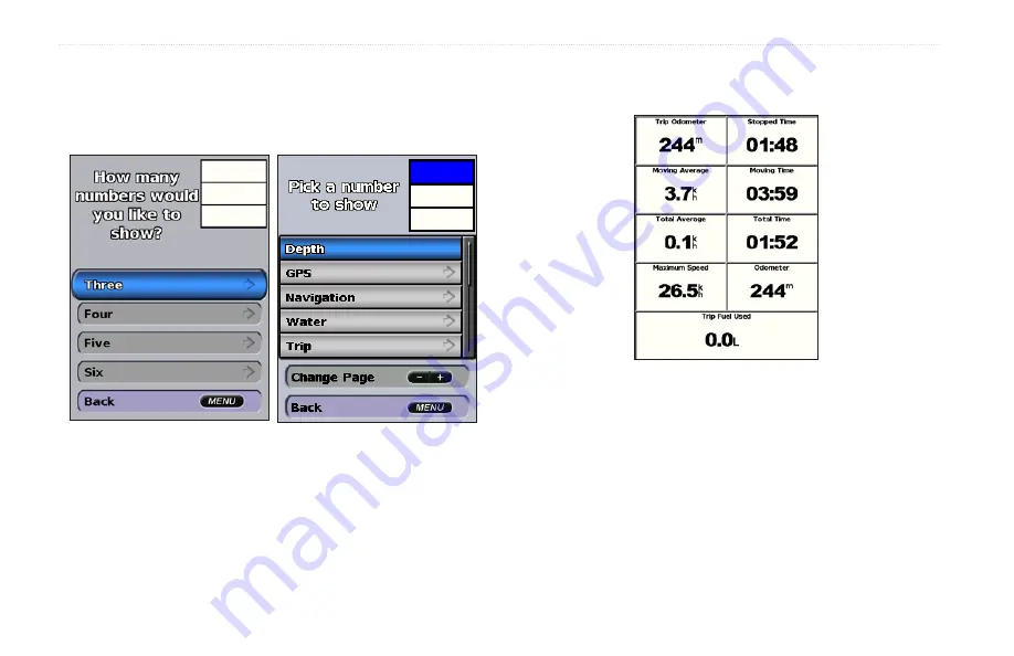
3.  Select the number of fields to show (3, 4, 5, or 6).
4.  Select information to show in each field. Select a field to view 

additional information that can be shown or select 

Change Page


and press the 

Range

 (-/+)

 keys to view additional fields.

Viewing Trip Information

  From the home screen, select 

Information

 > 

Dashboard 

Trip

.

  To reset the trip information, maximum speed, odometer, or all 

values, press 

MENU

 while viewing the trip information.

Viewing and Customizing Fuel Gauges and 

Engine Gauges

Viewing Engine Gauges

You must be connected to a NMEA 2000 network capable of sensing 

engine data to view engine gauges. See the 

GPSMAP 400/500 Series 

Installation Instructions

 for details. 

Содержание GPSMAP 190-01230-10

Страница 1: ...GPSMAP 400 500 series owner s manual...

Страница 2: ...copy of this manual must contain the complete text of this copyright notice and provided further that any unauthorized commercial distribution of this manual or any revision hereto is strictly prohib...

Страница 3: ...appear in the text They indicate that you should highlight a series of items on the screen using the Rocker and press the SELECT key after each item For example if you see select Charts Navigation Ch...

Страница 4: ...ngs 5 Inserting and Removing SD Cards 5 Understanding the Home Screen 6 Using Charts 7 Using the Navigation Chart 7 Changing the Navigation Chart Settings 11 Using the Split Navigation Chart 14 Using...

Страница 5: ...Setting the Total Fuel Onboard Alarm 53 Configuring My Boat 53 Configuring Other Vessels 54 Using Sonar 56 Understanding the Full Screen 56 Understanding the Split Frequency Screen 57 Understanding Th...

Страница 6: ...levant provisions of Directive 1999 5 EC To view the full Declaration of Conformity go to www garmin com compliance Product Registration Help us better support you by completing our online registratio...

Страница 7: ...g Started Getting Started Unit Overview POWER BACKLIGHT MENU ROCKER SELECT HOME RANGE MARK SD card slot GPSMAP 526 shown GPSMAP 421 451 521 551 GPSMAP 526 556 Power Data External GPS antenna NMEA 2000...

Страница 8: ...hange these settings later using the Configure screen page 5 Language select the language to display on the screen Store Demonstration select Off This option is only available the first time the unit...

Страница 9: ...onar depth data Select Yes or No Minimum Overhead Clearance select the minimum overhead clearance for your boat Refer to your boat specifications for more information AIS Alarm Range select the distan...

Страница 10: ...HOME RANGE MARK POWER BACKLIGHT Press and hold to turn the unit on or off Press and release to adjust the backlight and the day and night modes RANGE Press to adjust the range of the sonar Press to zo...

Страница 11: ...to navigate using simulator mode because the GPS receiver is turned off Any satellite signal strength bars shown are only simulations and do not represent the strength of actual satellite signals To...

Страница 12: ...heck the Garmin Web site at www garmin com Understanding the Home Screen Use the Home screen to access all other screens Press HOME from any screen to return to the Home screen Charts selects Navigati...

Страница 13: ...a BlueChart g2 Vision SD card or if your built in map supports Fishing charts Fishing Chart provides a view of the chart with enhanced bottom contours and without navigational data This chart works w...

Страница 14: ...e Navigation or Fishing chart in full screen mode without numbers Waypoints Tracks view add and configure waypoints page 25 and tracks page 28 Other Vessels view information about other vessels if you...

Страница 15: ...vide the current heading and an indicator that shows the bearing to the desired course appears while navigating Understanding How Wind VMG and Waypoint VMG Appear in the Data Bars The chartplotter aut...

Страница 16: ...olored line on the screen to the destination To create a route to a point on the chart see page 26 Panning the Navigation Chart Use the Rocker to move the map pointer away from your current location a...

Страница 17: ...an in depth graph for a tide station to help predict the tide level at different times or on different days Use the map pointer to highlight a tide station icon and press SELECT For more information...

Страница 18: ...lect Charts Navigation Chart MENU Chart Setup Chart Appearance Orientation changes the perspective of the map display North Up sets the top of the map display to a north heading Head Up sets the map d...

Страница 19: ...reater than the specified value are shaded in white The contour is always drawn at or deeper than the selected depth Select Auto to use the depth from the g2 Vision chart Symbols changes symbol prefer...

Страница 20: ...ting tricky shoals reefs bridges or channels and is beneficial when trying to identify entry routes and exit routes in unfamiliar harbors or anchorages To access the Perspective 3D screen from the Hom...

Страница 21: ...oggles the range rings on or off to provide distance measurement Lane Width adjusts the width of the course line drawn when navigating This setting also affects routes Route To but does not affect aut...

Страница 22: ...rance of the Mariner s Eye 3D screen select MENU Chart Appearance Style Selects how chart data is displayed over 3D terrain Classic uses color schemes to indicate 3D terrain Charts provides chart info...

Страница 23: ...sh Eye 3D Settings To access additional settings or options for the Fish Eye 3D screen press MENU View selects a fish eye view Fore Aft Port or Starboard Sonar Cone only available if sonar is present...

Страница 24: ...customize the appearance of the Fishing Chart screen select MENU Chart Setup page 11 Enabling High Resolution Satellite Imagery You can overlay high resolution satellite images on the land sea or bot...

Страница 25: ...e detail level higher page 12 Photo Overlay Off Land Only Photo Overlay Photo Overlay at 50 Photo Overlay at 100 Viewing Aerial Photos Preprogrammed BlueChart g2 Vision SD cards contain aerial photogr...

Страница 26: ...ion for tide station and current direction must be available in your preloaded map or BlueChart g2 Vision region You must also select the Animated value for the Tides Currents setting page 11 An indic...

Страница 27: ...contains detailed road and points of interest POI data which includes highly detailed coastal roads and POIs such as restaurants lodging local attractions and more For instructions on searching for an...

Страница 28: ...ached Use the Chart Sonar screen to view the Navigation chart Fishing chart Mariner s Eye 3D or Fish Eye 3D and sonar at the same time To view a split chart sonar screen 1 From the Home screen select...

Страница 29: ...from your location to a destination allowing you to add turns to the route Guide To uses BlueChart g2 Vision chart data to suggest the best path to your destination You must be using a BlueChart g2 Vi...

Страница 30: ...e 6 Follow the colored line on the screen to the destination To stop navigating Press MENU and select Stop Navigating To search for a destination by name 1 From the Home screen select Where To Search...

Страница 31: ...specific name symbol water depth or water temperature Delete deletes the waypoint Man Overboard designates the current location as a Man Overboard location Right or Left Arrow switches between waypoi...

Страница 32: ...ht corner of the screen Use the Rocker to move the pointer and measure the distance to other locations Select MENU Stop Measuring to remove the measuring line To view and sort or filter a list of all...

Страница 33: ...Repeat until the route is complete 5 Select MENU to save the route 6 Select the route to edit the route delete the route or navigate to the route To create a route using Automatic Guidance when using...

Страница 34: ...you are bypassing 3 Select Navigate To Go To or Route To Using Tracks A track is a recording of your path The track currently being recorded is the active track An active track can be saved To turn o...

Страница 35: ...ion or Perspective 3D chart select MENU Waypoints Tracks Active Track Active Track Options Record Mode select Off Fill or Wrap Off does not record a track log Fill records a track log until the track...

Страница 36: ...ng to the information on the chart Fishing Charts provides a view of the chart with enhanced bottom contours and without navigational data This chart works well for offshore deep sea fishing High Reso...

Страница 37: ...ewing Numbers You can view and customize numerical data including depth GPS information and navigation information You can customize the number of fields shown and the type of information shown in eac...

Страница 38: ...to view additional fields Viewing Trip Information From the home screen select Information Dashboard Trip To reset the trip information maximum speed odometer or all values press MENU while viewing t...

Страница 39: ...Rated minimum Represents the minimum value of the standard operating range Rated maximum Represents the maximum value of the standard operating range 1 From the Home screen select Information Dashboa...

Страница 40: ...which information appears in the gauges 1 From the Home screen select Information Dashboard Engine MENU Gauge Setup Engine Selection Edit Engines 2 Select First Engine 3 Select the number of the engi...

Страница 41: ...cted to a device capable of measuring fuel level fuel flow or both From the Home screen select Information Dashboard Engine Synchronizing Fuel Gauge Readings with Fuel Levels From the Home screen sele...

Страница 42: ...s wind speed data based on the flow of air experienced while on a boat in motion A wind sensor True Wind Shows wind speed data based on the flow of air experienced while on a stationary boat A wind se...

Страница 43: ...le and the downwind scale From the Home screen select Information Dashboard Wind MENU Select Change Upwind Scale Set the maximum and minimum angle values that appear when the upwind close hauled wind...

Страница 44: ...on for a different date Select Show Report to view the Current Prediction Report for the selected station Note You can select both tide station and current station information directly from the Naviga...

Страница 45: ...o format the data This only needs to be done the first time you copy or merge MapSource data to your chartplotter from a specific SD card 2 Check your MapSource version on the computer by clicking Hel...

Страница 46: ...rtplotter 4 Select the file name from the list The data is transferred from the SD card to the chartplotter To copy the built in maps to an SD card 1 Insert an SD card at least 4 GB into the SD card s...

Страница 47: ...nformation User Data Clear User Data 2 Select Waypoints Routes Saved Tracks or All 3 Select OK to delete the data Viewing Other Vessels To view information about other boats from the Home screen selec...

Страница 48: ...which the AIS vessel is moving Target is selected Target is activated The target appears larger on the chart A green line attached to the target indicates the heading of the target The MMSI speed and...

Страница 49: ...projected course of an activated AIS target appears as a dashed line on a chart or a 3D chart view The length of the projected course line is based on the value of the projected heading setting page 4...

Страница 50: ...AIS requires the use of an external AIS device and active transponder signals from other vessels You can configure how other vessels appear on a chart or on a 3D chart view The display range configure...

Страница 51: ...reported about a targeted AIS vessel 1 From the Home screen select Charts 2 Select Navigation Chart Fishing Chart Perspective 3D or Mariner s Eye 3D 3 Use the Rocker to select an AIS vessel Press SEL...

Страница 52: ...get will intersect the safe zone within the defined time interval ranging from 1 to 24 minutes 7 Select a time Viewing a List of AIS Targets Note Mariner s Eye 3D charts and Fish Eye 3D charts are ava...

Страница 53: ...S in Europe on or off WAAS EGNOS can provide more accurate GPS position information However when using WAAS or EGNOS the device takes longer to acquire satellites Speed Filter select On Off or Auto Th...

Страница 54: ...le and is automatically set to Auto DST Daylight Saving Time select Off On or Auto The auto setting automatically turns daylight saving time on or off depending on the time of year Baro Ref Time speci...

Страница 55: ...laced an appropriate distance from shore you can assess the placement of the auto guidance line using one or more familiar destinations that require navigation through a narrow waterway To set the dis...

Страница 56: ...a different destination each time until you are familiar with the functionality of the Shoreline Distance setting Configuring Communications Settings To change the communications settings from the Ho...

Страница 57: ...nes as numbers From the Home screen select Configure Communications NMEA 2000 Setup Label Devices Change Engine Labels Use Numbers To label engines as names 1 From the Home screen select Configure Com...

Страница 58: ...alarms Activation select whether the arrival alarm triggers on time to arrival or distance to arrival Change Time Change Distance if you have Activation set to Time select Change Time to set the numbe...

Страница 59: ...arm You can configure your chartplotter to sound an alarm when the total amount of remaining onboard fuel reaches the specified level Note To receive fuel level information your unit must be connected...

Страница 60: ...the on screen directions for calibration If you do not have a speed sensing device this menu does not appear Note If the boat is not moving fast enough or the speed sensor is not registering a speed a...

Страница 61: ...change the measured radius of the safe zone ring to a specified distance from 500 ft to 2 0 nm or from 150 m to 3 0 km or from 500 ft to 2 0 mi Time to Safe Zone sounds an alarm if AIS or MARPA determ...

Страница 62: ...s fishfinders GPSMAP 421s GPSMAP 451s GPSMAP 521s GPSMAP 526s GPSMAP 551s GPSMAP 556s Understanding the Full Screen Select the Full Screen option to view a full screen graph of the transducer s sonar...

Страница 63: ...left A 200 kHz frequency graph appears on the right From the Home screen select Sonar Split Frequency Depth temperature and speed Range Frequencies Split Frequency Understanding The Split Zoom Screen...

Страница 64: ...appears along the bottom The graph scrolls to the left as information is received Understanding the Temp Log Screen If you are using a temperature capable transducer the Temp Log screen keeps a graphi...

Страница 65: ...show or hide depth water temperature water speed if your transducer is capable battery voltage cruising navigation and the compass tape page 9 Note To display water temperature or water speed the con...

Страница 66: ...uttered decrease the gain Frequency when using a dual frequency transducer select how the frequencies appear on screen 200kHz 50kHz Dual or Auto Zoom zoom in to a section of the full screen The zoom i...

Страница 67: ...radio is capable GPS position information is transmitted with DSC calls X X X X The chartplotter can receive DSC distress and position information from the radio X X X X The chartplotter can track th...

Страница 68: ...eiving Distress Calls If your Garmin chartplotter and VHF radio are connected via NMEA 0183 or NMEA 2000 your chartplotter alerts you when your VHF radio receives a DSC distress call If position infor...

Страница 69: ...alls from your Garmin radio see your Garmin VHF Radio Owner s Manual For information on activating navigation to a man overboard location see page 25 Position Tracking When you connect your Garmin cha...

Страница 70: ...position reports 1 From the Home screen select Information Other Vessels DSC List 2 Select the vessel from the list Edit 3 Select Trail To change the symbol and color of the trail line for a vessel 1...

Страница 71: ...ng an AIS Target When you connect your Garmin chartplotter to a Garmin VHF NMEA 2000 compatible radio you can use the chartplotter interface to set up an individual routine call to an AIS target For m...

Страница 72: ...e brightness 320 234 pixels GPSMAP 526 and 556 5 0 in diagonal 12 7 cm Full VGA display with adjustable brightness 640 480 pixels capable of 4 096 colors Case Fully gasketed high impact plastic alloy...

Страница 73: ...than about 500 mi 800 km since it was turned off Update Rate once per second GPS Accuracy Position 49 ft 15 m 95 typical Velocity 0 164 ft sec 0 05 m sec steady state WAAS Accuracy Position 10 ft 3 m...

Страница 74: ...ut voltage to the maximum voltage allowed or less for your chartplotter Boat Is Not Moving Fast Enough to Calibrate the boat is not moving fast enough for the speed wheel to provide a valid speed Can...

Страница 75: ...figuration settings Entering Unsafe Region the boat is approaching an unsafe region as defined by your configuration settings Fish Alarm a beep sounds if enabled when a fish is detected This alarm doe...

Страница 76: ...y is Full Can t Create Track the track log memory is full No additional track log data can be stored without deleting old data to create memory space Track Truncated a complete uploaded track does not...

Страница 77: ...s to your computer 1 Remove the SD card from the chartplotter and insert it into an SD card reader that is attached to a computer 2 From Windows Explorer open the Garmin scrn folder on the SD card 3 C...

Страница 78: ...FOLLOWING SOFTWARE LICENSE AGREEMENT PLEASE READ THIS AGREEMENT CAREFULLY Garmin grants you a limited license to use the software embedded in this device the Software in binary executable form in the...

Страница 79: ...ons 4 C Calibrate Water Speed 54 celestial 38 Chart Sonar screen using 22 Chart Borders 13 chart data 9 charts detail 12 fish eye 3D 17 fishing 17 mariner s eye 3D 15 navigation 7 settings 11 Clear Us...

Страница 80: ...ight Sectors 13 M magnetic heading 37 Man Overboard 25 63 Manual Zoom 60 map datum 48 MapSource data 39 mariner s eye 3D 15 colors 16 mark current location 25 measuring distance 26 MENU key 4 messages...

Страница 81: ...reline Distance 49 simulator 47 mode 5 Skyview 47 software license agreement 72 software version 47 sonar advanced settings 60 cone 17 full screen 56 scroll speed 59 setting up 59 60 setup 59 specific...

Страница 82: ...stations 37 user data 39 W WAAS 47 water temperature 69 Waypoint IDs 51 waypoints 15 creating 25 deleting 25 26 depth 60 edit existing 15 25 mark current location 25 moving 25 viewing 39 Where To 23 W...

Страница 83: ......

Страница 84: ...m 2010 Garmin Ltd or its subsidiaries Garmin International Inc 1200 East 151st Street Olathe Kansas 66062 USA Garmin Europe Ltd Liberty House Hounsdown Business Park Southampton Hampshire SO40 9LR UK...

Отзывы: