background image

7

190-00607-02 Rev C

Detailed Operation

GDL 69/69A - FIS

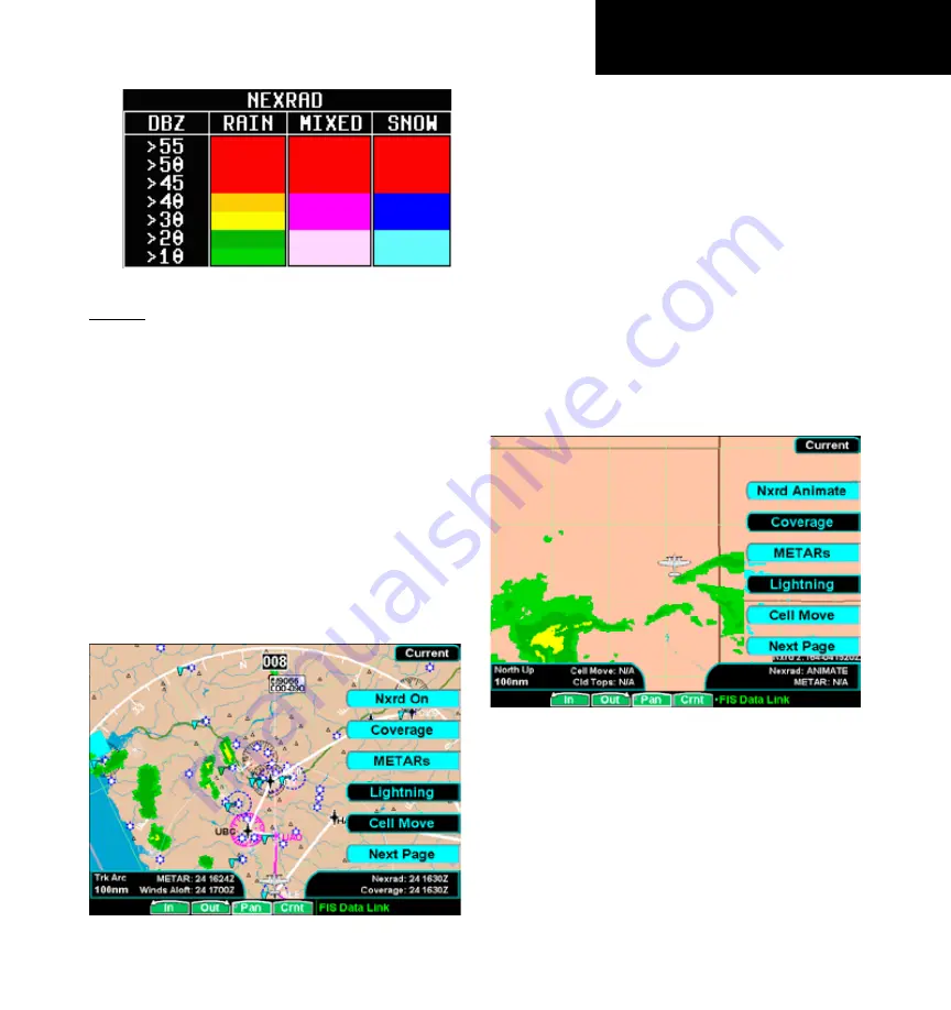
NEXRAD Color Legend

current

The Current sub-function provides an overlay of the 

currently selected weather information. The three pages 
of menu item selections allow you to modify the display 
of NexRad, radar coverage, METARs, lightning, thun-
derstorm cell movement, cloud tops, echo tops, winds 
aloft, information labels, flight plan course line, weather 
legends, map and navaids,  and map orientation. 

1.   Press the 

FN

 key and then the 

FIS

 functon key 

when dsplayed. 

2.   Press the fourth functon smart key on the rght 

to select the Current (

Crnt

) sub-functon. 

.   The 

MENU/ENT

 key brngs up menu tems for 

current weather products and more detal on 
each sub-functon. 

GDL 69/69A FIS Current Menu Page 1 with NEXRAD Activated

NEXRAD

When enabled, NEXRAD weather information is 

shown. Composite data from all of the NEXRAD radar 
sites in the United States is shown. This data is com-
posed of the maximum reflectivity from the individual 
radar sweeps. The display of the information is color-
coded to indicate the weather level severity. Informa-
tion about which sites are operational or off-line is 
also available (see coverage below). The update rate is 
every five minutes. Refer to the legend for a descrip-
tion of the color code. 

The Nexrad option has selections of Nxrd On, 

Nxrd Off, and Animate. The Animate selection will 
step through a number of time intervals to provide a 
view of weather trends. 

GDL 69/69A FIS Current Menu Page 1 with NEXRAD Animation

Up to the last 12 images are looped continuously. 

The age of individual images is shown in the lower 
right corner of the display. The time format shows 
hours and minutes with the Zulu date and time. For 
instance, 1:02 - 181930Z means the information is 
one hour and 2 minutes old and was reported on 
the 18th day of the month at 1930 Zulu time. When 
Nexrad animation is turned on, Coverage, METARs, 
Lightning, Cell Move, Cloud Tops, Echo Tops, and 

Содержание GMX 200

Страница 1: ...GMX 200TM Pilot s Guide Reference ...

Страница 2: ... onto a hard drive or other electronic storage medium to be viewed and to print one copy of this manual or of any revision hereto provided that such electronic or printed copy of this manual must contain the complete text of this copyright notice and provided further that any unauthorized commercial distribution of this manual or any revision hereto is strictly prohibited Information in this docum...

Страница 3: ...2006 2 0 190 00607 02 Rev 1 June 2006 2 01 2 02 190 00607 02 Rev A November 2006 2 03 190 00607 02 Rev B July 2007 2 12 190 00607 02 Rev C Ordering Information To receive additional copies of this GMX 200 Pilot s Guide order Part Number 190 00607 02 The GMX 200 Quick Reference Guide is Part Number 190 00607 03 ...

Страница 4: ...USE NO WARRANTIES FOR THE SOFTWARE THE SOFTWARE is provided AS IS and with all faults THE ENTIRE RISK AS TO SATISFACTORY QUALITY PER FORMANCE ACCURACY AND EFFORT INCLUDING LACK OF NEGLIGENCE IS WITH YOU ALSO THERE IS NO WARRANTY AGAINST INTERFERENCE WITH YOUR ENJOYMENT OF THE SOFTWARE OR AGAINST INFRINGEMENT IF YOU HAVE RECEIVED ANY WARRANTIES REGARDING THE GMX 200 OR THE SOFTWARE THOSE WARRANTIES...

Страница 5: ...e Supplemental Components are provided to you by MS Microsoft Corporation or their subsidiaries then you will be licensed by such entity under the same terms and conditions of this EULA except that i MS Microsoft Corporation or their subsidiaries providing the Supplemental Components will be the licensor with respect to such Supplemental Components in lieu of Garmin for the purposes of the EULA an...

Страница 6: ... knowing that you are the owner of the state of the art in aviation and navigation The GMX 200 architecture is designed to support full expansion for both software and hardware enhancements This flexibility protects your invest ment and allows for the ease of adding new features Our products are built to last and to allow the flexibil ity to meet your needs as they change in the future Accessories...

Страница 7: ...affic sensor documentation for additional information All pilots operators are reminded that the airborne equipment that displays other ADS B equipped aircraft and transponder equipped aircraft via TIS B is for pilot situational awareness and is not approved as a colli sion avoidance tool Any deviation from an air traffic control clearance based on cockpit information must be approved by the contr...

Страница 8: ...ons Menu 10 Thumbnail Feature 11 Traffic on Thumbnail 11 Terrain on the Thumbnail 11 Obstructions on the Thumbnail 11 Thumbnail Activation 11 Traffic Information Services TIS 12 Polar Navigation 12 Detailed Operation 15 Message Log MSG 15 Custom Map MAP 16 Initial Zoom Level 16 Map Scale 16 Auto Zoom 16 Pan 17 Info 17 Info In Pan Mode 17 Custom Map Menu Option Page 1 18 Flight Plan 18 Map Orientat...

Страница 9: ...ation 36 Shield 36 Shield Heights 36 Shield Ranges 36 TCAD 9900BX Menu Options 36 Altitude Option Relative Pressure 36 Filter 36 Volume 36 Approach Mode 36 Ground Flight Mode 36 ADS B Traffic TRAF Function 37 Traffic Description 38 TIS B Traffic 39 TIS B Limitations 40 Degraded Target 41 Target Color 41 Surface Targets 41 Traffic Altitude Values 41 Ident 41 Operation 41 Traffic Option Page 1 42 Tr...

Страница 10: ... Surface Analysis 64 City 65 Forecast Time 65 SIGMET 65 AIRMET 65 GDL 69 69A FIS Forecast Menu Page 2 66 Freezing Levels 66 County 66 Cyclone 66 TFR Label 66 Label 66 GDL 69 69A FIS Forecast Menu Page 3 66 Flight Plan 67 Legend 67 Map Detail 67 Map Orientation 67 Text 68 Selecting Categories and Messages 68 Sorting METAR TAF and TFR Text Messages 69 View 69 Temporary Flight Restrictions TFRs 69 St...

Страница 11: ...X 68 only 94 Radar Alert GWX 68 only 94 Radar Setup Page 94 Stabilization STAB 94 Target Alert GWX 68 only 94 Garmin GWX 68 Radar Description 97 Principles of Pulsed Airborne Weather Radar 97 Radar Signal Attenuation 98 Radar Signal Reflectivity 99 Precipitation 99 Ground Returns 99 Angle of Incidence 100 Operating DISTANCE 100 MAXIMUM PERMISSIBLE EXPOSURE LEVEL MPEL 100 Antenna Tilt Setup at Crui...

Страница 12: ...ooting 117 GDL 69 69A FIS Legends 119 Sample GDL 69 69A FIS Displays 120 Specifications 121 Physical Specifications 121 Power 121 Environmental 121 Care Information 122 Cleaning the Unit 122 Contacting the Factory 122 Glossary 123 Abbreviations 124 License and Registration Information 127 Contacting the Factory 127 Software License Agreement 127 Product Registration and Support 127 Limited Warrant...

Страница 13: ...u for each function Press the FN key to show the available functions Press the smart key below the function label to go to the desired function While in each function press the MENU ENT key to show the options for each func tion The options are shown on the right side of the display Press the Menu Item key to manipulate the options Some options toggle on off while some are tri state three choices ...

Страница 14: ...s about your flight plan and each waypoint The Terrain function shows a color coded map of terrain elevation in relation to your altitude An altitude sensor or TAWS sensor is required to provide altitude data The Flight Information Services FIS function is capable of displaying text and graphic weather informa tion with GDL 90 UAT and GDL 69 69A installations A subscription for the services is req...

Страница 15: ...t light conditions At the bottom of the display labels above the function keys change to show the different choices for each function to allow access to commonly used actions A typical Custom Map function display is shown below Controls Message Flag The Message flag will appear on the lower left side of the display when a new message is posted Go to the Mes sage function to view the information ab...

Страница 16: ...s by pressing and turning the knob Arrows will appear above the function keys indicat ing the direction to turn the rotary knob for the same effect A round push button symbol o will appear indicating that pressing the rotary knob will have the same effect Data Card Rotary Knob Rotary Knob Function Keys Arrows indicate rotary knob direction Round push button sym bol indicates the function affected ...

Страница 17: ...ill change with each key press between filled cyan active filled white interme diate and black inactive Menu Item Key Layout Menu Item Labels Menu Item Keys Data Card The Map databases and other information are stored on a data card The use of a data card allows you to easily update information Only change the data card when the power is turned off Only Garmin approved datacards can be used Data C...

Страница 18: ... of your heading Terrain The Terrain advisory flag will appear on the left side of the display when the terrain surface or obstacle altitude is within approximately 100 feet of your alti tude and within approximately two minutes of flight in any direction Lightning The Lightning advisory flag will show on the left side of the display when the WX500 sends an indica tion that lightning has been dete...

Страница 19: ...rom the optional Stormscope sensor Strike and cell information will not be displayed Terrain coverage is not available for some part of the terrain advisory coverage area Terrain advisories may not be provided When connected to the SL30 indicates the SL30 is not available or valid ILS OBS and VORs will not be highlighted Indicates that radar status information is not available from the optional ex...

Страница 20: ...ey to display available options Press the Menu Item key next to the dis played option to choose desired capabili ties Some options use multiple key presses for different states for the option Press the MENU ENT key again to extinguish the option display Refer to the Detailed Operation section for more details on each function Start Up Screen The Start Up screen is displayed while the GMX 200 goes ...

Страница 21: ...ion Press the FN key to view the different Functions The functions are shown above the function smart keys on the lower part of the display in blue Press the function key under the function label to activate that function The labels above the function key will change to reflect the custom smart controls for that function in green All of the described functions may not be available in each installa...

Страница 22: ...he TER key to enter the Terrain Function at this point will automatically adjust the zoom level to 10 NM and place the unit in full 360 mode to show overall situational awareness Returning To Normal Condition After evaluating the advisory to return to normal viewing simply select the original Function that was being viewed before the advisory was viewed When this is done the zoom level will be set...

Страница 23: ...ic causing an amber Traffic Alert TA traffic Note that the GMX 200 supports one traffic sensor in any installation Terrain on the Thumbnail Only Red terrain within the 5 NM range is presented on the Thumbnail This correlates directly to terrain that is rendered in red on the normal Terrain Function based on the internal terrain database Exter nal TAWS based terrain from the Goodrich Landmark is no...

Страница 24: ...ext time it communicates with your TIS A enabled transponder In the TIS B system the ground radar sensors col lect target information much the same as in the TIS A system However with TIS B all targets collected by the ground radar sensor are broadcast to all aircraft equipped with UAT data link radios and that are within coverage of UAT ground broadcast stations Polar Navigation When operating th...

Страница 25: ...ADS B Traffic Optional by Installation VFR Flight Plan Map Orient Invert Nav Data Label Press Menu Item Keys Custom Map IFR Map VFR Map Traffic Flight Plan Terrain FIS Data Link Lightning Profile Press Menu Item Keys TIS A Alert Mode Operate Mode Press Menu Item Keys MSG Press Function Keys MAP TRAF Summary SPLIT ABV NRM BLW UNR If Installed Not available unless altitude or TAWS installed sensor F...

Страница 26: ...14 190 00607 02 Rev C Getting Started Function Summary ...

Страница 27: ...s an unexpected set of condi tions This code may provide information about the cause of the reset and should be reported to Garmin Technical Support as soon as practical for further analysis Garmin Technical Support may also request a copy of other files located on the front loading datacard to assist with the analysis If an error condi tion does not return after the unit resets the cause is likel...

Страница 28: ...ut You can zoom in to 0 25 NM and zoom out to 1250 NM The scale distance is measured from the location of your aircraft symbol to the top of the screen The Map Scale is shown in the lower left corner of the screen The map orientation appears above the map scale Map Orientation and Zoom Level Map Scale Auto Zoom Auto Zoom is activated by adjusting the zoom level to the far extremes of the zoom rang...

Страница 29: ...pends on the amount of infor mation about the waypoint Press the WX key to view any available METARs for the selected waypoint Note that not all airports will have METARs available The Wx key is available with the GDL 90 UAT and GDL 69 69A FIS sensors Runway diagrams of airports will be displayed in the same orientation as the main map i e North Up Track Up or DTK Up If SafeTaxi information is ava...

Страница 30: ...een Track Up sets the current track of the aircraft as the top of the screen Track Up Arc sets the current track of the aircraft and a 120 arc at the top of the screen Track Up 360 sets the current track of the aircraft at the top of the screen and a 360 ring with the aircraft symbol position in the center Desired Track Up sets the desired track to the next waypoint as the top of the screen Press ...

Страница 31: ...resented in this list NOTE The pilot must be aware that not all charts in the loaded database can be used as an overlay The Load Chart function is automatic when connected to a GNS 480 series GPS receiver and the AutoLoad Chart option is enabled in the SYS function Overlaid chart labels are always oriented North Up To prevent confusion Intersection labels from the underlying map may be deselected ...

Страница 32: ...l lines Although these areas are highlighted as places where extra caution is war ranted and advised they do not relieve the pilot of the responsibility to see and avoid other traffic or obsta cles on the airport surface or in the air All taxiway and runway intersections should be approached with caution whether they are marked with hot spots or not Runways where Land and Hold Short Operations LAH...

Страница 33: ...lected VOR Highlight The GMX 200 highlights the VOR in magenta on the moving map when the SL30 is either tuned to or monitoring a nearby VOR station The highlighted VOR station is determined by using the tuned or monitored VOR frequency of the SL30 with the GMX 200 internal database Custom Map information when connected to SL30 The SL30 must be receiving a valid signal from the VOR The VOR informa...

Страница 34: ... the GMX 200 must have airports turned on for this feature to be active NDBs The NDBs option allows you to choose the type of NDB information displayed on the Map screen You may select the display of NDB icon and identifier icon only or no information by each subsequent press of the NDB Menu Item key Intersections The Intersections option allows you to choose the type of Intersection information d...

Страница 35: ... or less High Airways The High Airways option allows you to control the display of High Airways You may select the display of the airway and label airway alone or no display of Low Airways by each subsequent press of the Menu Item key High Airways are drawn when the zoom scale is 150 NM or less Water The Water option allows you to control the display of streams rivers and lakes Pressing the Menu I...

Страница 36: ...lled and active Pressing the METARs menu item toggles the display of METAR symbols on and off Lightning The Lightning option allows you select the overlay of Lightning strike symbols on the Custom Map if the optional FIS lightning sensor is installed and active Pressing the Lightning menu item toggles the display of Lightning symbols on and off Cell Move When optional equipment is installed and en...

Страница 37: ...s and the Airport Chart option is enabled the ChartView airport chart will be displayed The SafeTaxi airport diagram will be dis played if the Airport Chart option is disabled Terrain The Terrain option allows you select the display of topographical features Pressing the Menu Item key next to the Terrain option scrolls between sectional absolute terrain awareness relative or no display of topograp...

Страница 38: ...Strikes and Menu Items Page 4 Current coverage for obstructions is North America only and are drawn only when the zoom scale is 50 NM or less Traffic The Traffic option turns the display of traffic infor mation on or off ADS B Traffic information includes the location and identifier of a reporting aircraft its direction of travel elevation and the estimated path for the selected time interval See ...

Страница 39: ... scale is 15 NM or lower with progressively more details shown as the scale decreases Hot Spots Airport diagrams may show areas where extra vigilance is recommended due to traffic congestion visibility constraints or other unique circumstances These areas are called hot spots and are identified by circular or elliptical lines Although these areas are highlighted as places where extra caution is wa...

Страница 40: ...th as the top of the screen Track Up sets the current track of the aircraft as the top of the screen Track Up Arc sets the current track of the aircraft and a 120 arc at the top of the screen Track Up 360 sets the current track of the aircraft at the top of the screen and a 360 ring with the aircraft symbol position in the center Desired Track Up sets the desired track to the next waypoint as the ...

Страница 41: ... Item key High Airways The High Airways option allows you to control the display of High Airways You may select the display of the airway and label airway alone or no display of Low Airways by each subsequent press of the Menu Item key Airport Chart Jepp ChartView Airport surface charts provide a graphical presen tation of the airport surface area runways taxiways buildings towers and other object...

Страница 42: ...ted for selection from the Custom Map Because of this it is possible that approach charts that are viewable under the ChartView Function may not be presented in this list The Load Chart item is not avail able with FliteCharts NOTE The pilot must be aware that not all charts in the loaded database can be used as an overlay The Load Chart function is automatic when connected to a GNS 480 series GPS ...

Страница 43: ...creases VFR En Route Chart page with Menu Items Hot Spots Airport diagrams may show areas where extra vigilance is recommended due to traffic congestion visibility constraints or other unique circumstances These areas are called hot spots and are identified by circular or elliptical lines Although these areas are highlighted as places where extra caution is war ranted and advised they do not relie...

Страница 44: ...he top of the screen and a 360 ring with the aircraft symbol position in the center Desired Track Up sets the desired track to the next waypoint as the top of the screen Press the Menu Item key next to this option to scroll through the options Invert The Invert option changes the text and background color Inverting the display may help readability for the current lighting conditions and the color ...

Страница 45: ...function is based on the internal terrain database The profile display is always oriented in the Track Up mode where the depicted terrain is a cross section of the terrain just below the aircraft s current track Obstacles are not shown on the profile display and the aircraft current altitude is provided next to the ownship symbol The altitude scale adjusts automatically with the aircraft altitude ...

Страница 46: ...corner of the screen Symbology Traffic is shown with either the relative or absolute altitude indicated above or below the target symbol If the traffic is below or equal to your ownship altitude the label is shown below the symbol If the traffic is above your ownship altitude the label is shown above the symbol For traffic with no altitude information the label will be shown as dashes Other traffi...

Страница 47: ...in the Test Mode Not Displayed An amber Traffic Not Displayed will be shown if the Traffic sensor has failed TAS Fail System Failure shown in yellow in the lower right corner TAS Data Fail Label set sent by the TAS unit has failed the integ rity check Shown in yellow in the lower right corner TAS Data Time Out GMX 200 is not receiving labels from the TAS unit Shown in yellow in the lower right cor...

Страница 48: ...the available modes See the TCAD operator s manual for additional details Shield Heights This allows the shield heights to be adjusted for the En Route Standard and Terminal shield modes See the TCAD operator s manual for additional details Shield Ranges This allows the shield ranges to be adjusted for the En Route Standard and Terminal shield modes See TCAD operator s manual for additional detail...

Страница 49: ...ve reports from other suit ably equipped aircraft within reception range Additionally these broad casts can be received by Ground Based Transceivers GBTs and used to provide air traffic surveillance services along with fleet operator monitor ing of aircraft No ground infrastructure is necessary for ADS B equipped aircraft to detect each other In the United States two different data links have been...

Страница 50: ...e one and only one place for the pilot to enter the ATC code Consult your installing avionics shop with questions Additionally UAT systems provide a VFR mode that may be used by pilots when not wanting to receive air traffic services The Set 1200 feature will broadcast a VFR Flight ID to other aircraft and ground receivers similar to using a 1200 transponder code ADS B is intended to be used both ...

Страница 51: ...re complete traffic picture in situations where not all nearby aircraft are equipped with ADS B The advisory only application enhances a pilot s visual acquisition of other traffic TIS B service is becoming available in selected locations where there are both adequate surveillance coverage from ground sen sors and adequate broadcast coverage from Ground Based Transceivers GBTs The quality level of...

Страница 52: ... TIS B traffic reports will occur less often than ADS B traffic updates TIS B position updates will occur approximately once every 3 13 seconds depending on the radar coverage In comparison the update rate for ADS B is nominally once per second d The TIS B system only detects and uplinks data pertaining to transponder equipped aircraft Aircraft without a transponder will not be displayed as a TIS ...

Страница 53: ...plays are the actual values in feet 100 100 feet Ident The Ident smart key allows the pilot to initiate a sequence that is equivalent to a standard transponder Ident as requested by ATC When pressed the Ident flag will be displayed while the GDL 90 UAT broadcasts the ident The GMX 200 must be configured to be the UAT s control panel for this function to be available ADS B Broadcast ID Info Operati...

Страница 54: ...e ADS B Broadcast Mode Control For ADS B equipped installs this feature allows the pilot to control the broadcast mode of their aircraft Broadcast options are controlled via the Traffic Function Menu and allow the pilot to toggle between Broadcast FID Broadcast VFR The GMX 200 must be configured as the UAT s control panel to make this function available Broadcast FID Causes the currently set Fligh...

Страница 55: ...d as the UAT s control panel to make this function available Press the Next Page key to display the next page of menu items Traffic Menu Option Page 2 The second menu option page of the Traffic func tion lets you select options for the choices of Time Altitude Filter Altitude type Flight Plan and Traffic Map Orientation ADS B Traffic Menu Items Page 2 Time The time interval option sets the amount ...

Страница 56: ...light Plan option toggles between showing and not showing the Flight Plan route line If the flight plan provided by the navigator to the GMX 200 has an invalid cross track error the ownship symbol will have a red X placed over it Traffic Map Orientation The Traffic Map Orientation option lets you choose between a 360 degree compass rose or an arc that covers about 90 degrees over the top of the di...

Страница 57: ...ed for as a result of displayed TIS A targets Refer to the TIS A Sensor documentation for additional information TIS A Traffic in the upper left corner Up to 12 of the nearest targets are listed ADS B Traffic Text Display Enter FID The Enter Flight ID option allows you to edit your broadcasted Flight ID when the editing function is enabled The Function smart keys at the bottom of the screen change...

Страница 58: ... also include a climb or descent arrow next to the relative altitude when the climb or descent rates are greater than 500 feet per minute Targets are displayed at full brightness for the first six 0 to 6 seconds If the TIS A data is not refreshed the targets will be displayed at a reduced brightness for the next six 6 to 12 seconds during an interval known as coasting and removed from the display ...

Страница 59: ...e Traffic advisory target with direction of flight vector and relative altitude Traffic Status Indicators The following status indicators are displayed in the lower right portion of the display TIS Operating to indicate the TIS A Sensor is operating and within TIS A service coverage TIS Coasting to indicate that the target informa tion is between 6 and 12 seconds old This may happen if the TIS A s...

Страница 60: ...box shows the aircraft current position in latitude and longitude ground speed and track In the lower right corner information for the current waypoint is dis played in the Waypoint Info box The Nearest Center frequency is shown just above the flight plan The Flight Plan function does not have any options If the flight plan provided by the navigator to the GMX 200 has an invalid cross track error ...

Страница 61: ...art keys to move up and down the flight plan list in the Current Flight Plan window The details for the selected waypoint are shown in the Waypoint Info window on the right side of the screen Flight Plan Information PDX selected 3 Each press the Info function key will step through the available pages of Waypoint Information ...

Страница 62: ...display are shown below 1000 feet below your current altitude Yellow 2000 feet below your current altitude Black Red Green Current Altitude Highest Terrain More than 2000 feet below your current altitude 1 below or at your current altitude 00 feet Above your current altitude Red Terrain Elevation Color Coding Reference Normal Terrain Model NOTE The Terrain function shows you the gen eral terrain e...

Страница 63: ... the GMX 200 has an invalid cross track error the ownship symbol will have a red X placed over it TRK Up Arc TRK Up 360 The Terrain function display is always in the Track Up mode Pressing the Menu Item key toggles the map orientation between Track Up Arc and Track Up 360 Terrain option page showing 360 degree arc Set Barometer Pressure Altitude only Use the Set Barometer option to enter the corre...

Страница 64: ...stem TAWS the Baro and Alt fields normally present on the Navigational Bar in the Custom Map function will not be displayed The following table describes annunciations that may occur in the TAWS function These annunciations are based on external information If an annunciation appears check the TAWS equipment and documenta tion for further information Annunciation Description TAWS sensor is inopera...

Страница 65: ...le for that area and rainfall in that area is unknown When weather data is received the airborne system will display that data for 20 minutes If no new data has been received for a given area the rainfall will be removed after 20 minutes and the area will revert back to the cyan checkerboard pattern The FIS Function is based on a ground to air data link and requires that the appropriate ground sys...

Страница 66: ...ry The text for the selected message is shown in the FIS Message window in the upper portion of the screen 7 Press the Æ arrow key to move to the FIS message time stamp in the farthest right column The smart key to the farthest right on the bottom of the screen will change to View Press View to expand the FIS Message window at the top of the screen A green arrow at the bottom of the FIS Message wi...

Страница 67: ... keys at the bottom of the screen zoom IN and OUT on the map 3 The PAN key brings up the movement menu item keys at the right of the screen that allow you to move the view of the map 4 The fourth function smart key on the right will step through the four sub functions of GDL 69 69A FIS Current Forecast Text and Status 5 The MENU ENT key brings up menu items for more detail on each sub function Wea...

Страница 68: ...y put a radar off line NEXRAD Limitations Certain limitations exist regarding the NEXRAD radar displays Some but not all are listed for the user s awareness NEXRAD base reflectivity does not provide sufficient information to determine cloud layersorprecipitationcharacteristics hailvs rain etc NEXRAD base reflectivity is sampled at the minimum antenna elevation angle An individual NEXRAD site canno...

Страница 69: ...adar sites in the United States is shown This data is com posed of the maximum reflectivity from the individual radar sweeps The display of the information is color coded to indicate the weather level severity Informa tion about which sites are operational or off line is also available see coverage below The update rate is every five minutes Refer to the legend for a descrip tion of the color code...

Страница 70: ...able GDL 69 69A FIS Radar Coverage and Winds Aloft METARs When enabled METARs METeorological Aviation Reports are shown as colored flags at airports that provide METAR reports Press the METARs key to enable or disable METARs Refer to the Legend for a description of the color code The update rate is every 12 minutes METAR Legend GDL 69 69A FIS METARs Lightning When enabled lightning strikes and cel...

Страница 71: ... intervals to provide a view of weather trends Up to the last 12 images are looped continuously The age of individual images is shown in the lower right corner of the display The time format shows hours and minutes with the Zulu date and time For instance 1 23 181910Z means the information is one hour and 23 minutes old and was reported on the 18th day of the month at 1910 Zulu time When Cloud Top...

Страница 72: ...ayed at the same time Selecting Echo Tops automatically disables Cloud Tops Winds Aloft The Winds Aloft selection provides the pilot with the wind speed and direction The winds at a given altitude are selected in the Winds Aloft Alt menu item The selected altitude is shown along with the product time The update rate is every 12 minutes Press MENU ENT key and then press the Winds Aloft key to toggl...

Страница 73: ...ENU ENT key and then press the Label key to toggle the station labels on and off Flight Plan Press MENU ENT key and then press the Flight Plan key to toggle the Flight Plan course line on and off The magenta line is the active leg If the flight plan provided by the navigator to the GMX 200 has an invalid cross track error the ownship symbol will have a red X placed over it Legend Press MENU ENT ke...

Страница 74: ...entified by circular or elliptical lines Although these areas are high lighted as places where extra caution is warranted and advised they do not relieve the pilot of the responsibility to see and avoid other traffic or obstacles on the airport surface or in the air All taxiway and runway intersec tions should be approached with caution whether they are marked with hot spots or not Runways where L...

Страница 75: ...s certain age thresholds A product time aging table is shown below For a GMX 200 that does not have time available from a GPS receiver age is based on the time the data was received from the GDL 69 69A sensor In this case the age of the data may be older than what is shown by the color coding Animating Nexrad Cloud Tops or Surface Analy sis products will disable the depiction of other enabled prod...

Страница 76: ...r intervals of current 12 24 36 and 48 hours The Forecast Time menu item will step through the intervals manually The Surface Animate selection will automatically step through the times to provide an indication of how the weather systems are expected to move Animating Surface Analysis products will disable the depiction of other enabled products The product time for the other enabled products will...

Страница 77: ...bulence dust and volcanic ash as issued by the National Weather Service The update rate is every 12 minutes XM FIS AIRMET and SIGMET Legend Refer to the Legend for a description of the color coding 1 Press the Å or Æ arrow keys to display the legends for the selected services 2 Press Done to turn the Legends off AIRMET AIRMETs AIRman s METeorological Information advises the pilot of weather that m...

Страница 78: ...gend for a description of the color coding XM FIS County Warnings Legend 1 Press the Å or Æ arrow keys to display the legends for the selected services 2 Press Done to turn the Legends off Cyclone This product is not available at this time TFR Label Press MENU ENT key and then press the TFR Lbl key to toggle the TFR Identifier Labels on and off The TFR Identifier Labels note the TFR number and upp...

Страница 79: ...decreases Airport diagrams may show areas where extra vigilance is recommended due to traffic congestion visibility constraints or other unique circumstances These areas are called hot spots and are identified by circular or elliptical lines Although these areas are highlighted as places where extra caution is war ranted and advised they do not relieve the pilot of the responsibility to see and av...

Страница 80: ...yed 2 Press the fourth function smart key on the right to select the Text Text sub function 3 The MENU ENT key brings up menu items for more detail on each sub function Selecting Categories and Messages 1 Press the Ç or È function smart keys to move up or down the FIS category list The selected category is highlighted XM FIS Text Messages METAR Selected 2 Press the Æ arrow key to move to the items...

Страница 81: ...he View menu item to toggle between the choices Temporary Flight Restrictions TFRs The full page view of the TFR is available when TFR Text is selected TFR information includes type minimum and maximum altitude and Notam ID If TFR text extends beyond the page size no scrolling is available 1 Press the FN key and then the FIS function key when displayed 2 Press the fourth function smart key on the ...

Страница 82: ...s page displays a list of all products supported by the GMX 200 The status is shown as available or not available Available means the product is a part of your chosen subscription level and the GMX 200 has data that can be displayed A time stamp will indicate the last received product time which is the time the product was generated for transmission Not Available means the product is not included ...

Страница 83: ...and then the FIS function key when displayed 2 Press the fourth function smart key on the right to select the Status Status sub function 3 Press MENU ENT to display the Products menu item 4 Press the Products key to toggle to the Diag nostics display The Diagnostics page information is displayed including Radio IDs Service Class and Weather Products 5 Follow the XM Satellite Radio Activation proce...

Страница 84: ...hardware IDs XM Satellite Radio Activation Weather and or audio data from your GDL 69 69A are provided by XM Satellite Radio a company separate and independent from Garmin Corporation Have your radio hardware IDs ready before contacting XM Satellite Radio During the process you can select services for subscription Keep in mind that the GDL 69 has no audio capability audio services will not be avai...

Страница 85: ...you select menu items for the choices of Flight Plan Display view Lightning groups Heading Stabilization and Stormscope System Data info The last option selection Next Page takes you to the next page of menu items Lightning Function Menu Items Page 1 Flight Plan The Flight Plan key controls the display of the Flight Plan course line Pressing the Flight Plan key toggles between showing and not show...

Страница 86: ...Page key to display the next page of menu items Lightning Menu Page 2 The second option page of the Lightning func tion lets you select options for the choices of Demo Self Test for the Stormscope Noise Monitor and Strike Test The last menu item key takes you back to the first page of menu items Lightning Function Menu Items Page 2 Demo The Demo option places the WX500 sensor in a demonstration mo...

Страница 87: ...peration Strike Test The Strike Test feature is a function of the WX500 For details about using this feature refer to the WX500 owner s documents The Strike Test feature is used by installers to verify proper operation of the WX500 Test strikes are sent to the antenna The received test strike is then visually presented on the screen Antenna Change Message When an Antenna Change message is shown th...

Страница 88: ... they can be displayed only in the Chart function and cannot be viewed on a moving map with position overlay SafeTaxi airport surface diagrams are geo refer enced and are displayed only on the moving map with position overly and cannot be viewed in the Chart function SafeTaxi and FliteChart databases are derived from different sources and are regularly updated They may not contain airport surface ...

Страница 89: ...ight by one position with each press Press MENU ENT to select the desired Airport ID Search for the Airport ID in the FliteChart Function 4 Press the Select Airport Menu Item key and highlight the desired airport with the arrow smart keys or the rotary knob and then press the Select key or the knob pushbut ton Selecting the airport for a Chart in the FliteChart Function 5 Highlight the desired cha...

Страница 90: ... multiple key strokes to look up a specific chart it is not recom mended as the primary mechanism for accessing the charts but does allow for flexibility When an airport is located it will be set as the currently selected airport Airport identifiers must be entered with the prefix in the United States the prefix is K 1 Press MENU ENT and then press the Search ID Menu Item key and select the Airpor...

Страница 91: ...in the FliteChart Function 3 Once the airport is located the Select Chart menu is presented see below allowing a specific chart for that airport to be viewed Select Chart The Select Chart operation allows the list of charts for the currently selected airport to be listed in a pop up list 1 If this page was not reached automatically from the SelectAirport selection press MENU ENT and then press the...

Страница 92: ... sole replacement for the paper chart within the cockpit The presentation of the chart data is intended for supplemental use and to provide additional situational awareness The pilot must still have access to the printed chart as required by FAA regulations ChartView as viewed on the Custom Map Page Overview Charts are viewed either as a dynamic overlay on the Custom IFR Map or as a static page th...

Страница 93: ...aints or other unique circumstances These areas are called hot spots and are identified by circular or elliptical lines Although these areas are highlighted as places where extra caution is war ranted and advised they do not relieve the pilot of the responsibility to see and avoid other traffic or obstacles on the airport surface or in the air All taxi way and runway intersections should be approa...

Страница 94: ...referenced based on present position Loading the Approach Chart Once the airport is selected the individual approach chart to be overlaid can be loaded from a list of geo referenced approach charts available for that airport Not all approach charts can be overlaid in this fashion and only geo referenced charts will be presented for selection from the Custom Map Because of this it is possible that ...

Страница 95: ... on the screen at all times When an approach chart is loaded and being displayed the auto zoom mode will limit the low end zoom level to 5 NM as the current waypoint is being approached This prevents the display from zooming into a level where the overall situational awareness relative to the approach as a whole is lost This can be over ridden by taking the unit out of auto zoom mode This limit do...

Страница 96: ...om the Custom IFR map as described in previous sections All charts within the database geo referenced or not can be statically viewed from the ChartView Func tion Only geo referenced charts can be loaded for map overlay purposes The ChartView Function will retain the last view set and will not change the chart zoom level or pan setting when the function is exited and re entered allowing it to oper...

Страница 97: ...ess MENU ENT and then the Menu Item key for the desired function ChartView Function Menu Items Search ID The Search ID menu item within the ChartView Function allows you to search for a specific airport identifier As this operation requires multiple key strokes to look up a specific chart it is not recom mended as the primary mechanism for accessing the charts but does allow for flexibility When a...

Страница 98: ... Within this list a circular earth symbol indicates that the chart is geo referenced and therefore can be loaded for use as an overlay on the maps If a red X is presented through the earth symbol then that specific chart is not geo referenced and can be viewed but not loaded as a map overlay Selecting a Chart from a list in the Chart Function View Loaded The Select Loaded operation allows the curr...

Страница 99: ...rking with surface charts Viewing Surface Charts The airport surface charts are treated similarly to approach type charts in that they can be viewed through both the ChartView Function and on the Custom Map IFR Map as an overlay However as there is only one unique surface chart for a given airport it does not need to be manually loaded for display The nearest available airport surface chart will a...

Страница 100: ...ition logic is based solely on aircraft ground speed When an approach chart is loaded and being flown and the aircraft ground speed drops below the air ground transition speed set in the SYS Function it is assumed that a landing has been performed At this point the loaded approach chart is automatically unloaded and the airport surface chart will be pre sented on the screen showing runways taxiway...

Страница 101: ...set to 0 5 NM The default air zoom level is set to AUTO Airport Chart menu item is enabled Typical Taxi Scenario On power up and GPS position acquisition the Custom Map Function will show the aircraft on the surface chart at a zoom level of 0 5 NM The air craft will be shown relative to taxiways and runways throughout the taxi procedure Typical Take Off Scenario On take off roll when the aircraft ...

Страница 102: ...old Mode l l l Tilt Control l l l Bearing Control l l Range Control l l l Gain Control l l l Bearing Cursor l l Tilt Cursor l l l Stabilization l l l Sector Scan l Function GWX 68 ART2000 RS 181A RS 811A Target Alert l Radar Alert l On initial power up and entry to the Radar Func tion the radar unit may go to the Off mode Selections can be made to command the unit into one of the following initial...

Страница 103: ... unit Radar returns are painted in the following colors Black Green Yellow Red Magenta Black is the weakest return while Magenta shows where the strongest returns were obtained While in the weather mode GWX 68 only the gain can be adjusted with the Gain and Gain keys MAP Mode The Map MAP mode is used for obtaining returns from the ground Map mode is available for the GWX 68 ART2000 2100 RS 811A an...

Страница 104: ...keys Values for the radar are shown in the table below Unit GWX 68 ART2000 RS 181A RS 811A Range NM 2 5 320 10 240 10 240 Tilt Control The Tilt TILT control is used to adjust the current tilt angle of the radar head when horizontal sweeping is being performed While in the Horizontal mode the tilt is adjusted using the Tilt and Tilt keys Values for the radar are shown in the table below Radar Tilt ...

Страница 105: ...n Control ART2000 2100 and RS 181A RS 811A GWX 68 ART2000 2100 RS 181A RS 811A Gain dB 28 3 5 Weather and Map modes 31 5 0 Map mode only 31 5 0 Map mode only Hold Control The Hold mode is used to freeze the display While in the hold mode the green RDR indicator flashes indicating that the display is not being updated but the radar is continuing to transmit Cursor Pre Select Operation GWX 68 and AR...

Страница 106: ...en a Target Alert is active for two consecutive sweeps within 10 of the current heading When the Radar Alert is active a flag appears and is displayed for 60 seconds after the end of the last Target Alert The flag will be displayed along the left side of the display regardless of the active function See Target Alert on the following page Radar Setup Page Pressing the Menu key while in the Radar Fu...

Страница 107: ...ge with Target Alert Active Target Alerting is enabled by pressing the MENU ENT key when the Radar is in TEST or ON modes Press the MENU ENT key and then the TRGT ALERT key to enable and disable Target Alerting Radar Setup Page with Target Alert Radar ...

Страница 108: ... performance will be impaired and indicated return intensity is not reliable Power off the radar The radar needs service TEMP The temperature is too high to safely activate the radar transmitter Power off the radar Do not use the radar until its tempera ture falls and the fault clears XMITTER A problem is detected in the receiver or transmitter The unit may be hazard ous to use Power off the radar...

Страница 109: ...rowave pulses are focused and radiated by the antenna with the most intense energy in the center of the beam and decreasing inten sity near the edge The same antenna is used for both transmitting and receiving The returned signal is then processed and displayed on the GMX 200 MFD Radar detection is a two way process that requires 12 36 micro seconds for the transmitted microwave pulses to travel o...

Страница 110: ... sources distance and precipitation Attenuation because of distance is due to the fact that the amount of radar energy at a distance from the antenna is inversely proportional to the square of the distance The reflected radar energy from a target 40 miles away that fills the radar beam will be one fourth the energy reflected from an equivalent target 20 miles away This would appear to the operator...

Страница 111: ... target Angle of Incidence and the reflective properties of that target The gain can be adjusted so shorelines rivers lakes and cities are well defined Increasing gain too much causes the display to fill in between targets thus obscuring some landmarks Cities normally provide a strong return signal While large buildings and structures provide good returns small buildings can be shadowed from the r...

Страница 112: ...ngle the resulting detectable range is increased for mountainous terrain Operating DISTANCE The following information establishes a minimum safe distance from the antenna for personnel near an operating airborne weather radar The minimum safe distance is based upon the FCC s exposure limit at 9 3 to 9 5 GHz for general population uncontrolled environments which is 1 mW cm2 See Advisory Circular 20...

Страница 113: ...d returns from weather returns in relatively flat terrain This will place the bottom of the radar beam level with the ground Return the antenna tilt to the previous setting after a few sweeps NOTE At aircraft altitudes under 5 000 feet AGL false returns are possible due to reflections from side lobe beams If the aircraft is above 29 000 feet be cautious of any target return that gets to 30 nautica...

Страница 114: ...ed or magenta are associated with hail or turbulence as well as heavy precipita tion Vertical scanning and antenna tilt manage ment is necessary to identify areas of maximum intensity Along squall lines individual cells are in different stages of development Areas between closely spaced intense targets may contain developing clouds not having enough moisture to produce a return How ever these area...

Страница 115: ...103 190 00607 02 Rev C Detailed Operation Steep Gradient Squall Line Hook or Finger Scalloped Edge Cell Irregularities The Blind Alley Radar ...

Страница 116: ...drafts carrying water high enough to freeze Therefore the higher the top of a thunderstorm the greater the probability that it con tains hail The height can be determined by vertically scanning the target return Hail usually has a film of water on its surface making it s reflective characteristics similar to a very large water droplet Because of this water film and because hail stones usually are ...

Страница 117: ...hted channel and the Volume setting The Active Channel window shows the Channel Name and Number artist Song Title Category and provides an indication of signal strength A bar graph next to the antenna symbol describes the signal strength Maximum signal strength is shown by three full bars The rotary knob initially will allow you to scroll through the song list Pressing the rotary knob changes to C...

Страница 118: ... Menu Page 1 Radio ID Each XM radio contains a unique ID that allows XM to communicate over the air with the radio The owner must activate XM service by providing the Radio ID to XM to authorize the installed services for that radio Activation information is included in a separate information package included with your unit XM Data and Audio Radio ID shown at top of screen 1 In the XM radio functi...

Страница 119: ...et number 4 Press the MENU ENT key to save the channel into the selected preset number Last Channel The Last Channel menu item allows you to return to the last tuned channel 1 In the XM radio function press the MENU ENT key 2 Press the Last Channel key 3 The last tuned channel in the XM Radio func tion will be selected Menu Pages 2 4 The second third and fourth option pages list Presets 3 through ...

Страница 120: ... audio volume Mute 1 In the XM radio function press the Mute key to mute or un mute the audio Note that the volume is muted when the GDL 69A is turned on Channels The Channel feature is used to navigate through the channels in the selected category XM Audio Radio Channel Selection Controls 1 In the XM radio function press the double Ù or Ú keys to up or down through the available channels 2 Press ...

Страница 121: ...ugh the available categories 3 Press the Sel menu item key to select the highlighted category 4 You can now use the Channel function to select a channel from the category list selected Direct Access Channels can be accessed directly by entering the channel number using the smart keys Direct Access of XM Audio Radio Channels 1 In XM mode press the Direct function smart key The number values will be...

Страница 122: ...ively These IDs serve as identification codes for your XM equipped GDL 69 69A and are needed in the activa tion process The ID s is attached to this instruction sheet and printed on a label on the back of the unit The IDs can also be retrieved through the GMX 200 in the Radio ID page of the XM Satellite Radio function Contact your dealer or customer service if you are unable to locate the radio ha...

Страница 123: ...nal The radio is not able to receive a strong enough XM signal to decode it Loading Acquiring channel audio or information Either the corresponding audio or text is temporarily unavailable for a given channel selected because the radio still has to receive and decode this information Off Air Channel not in service A valid XM channel number and its corresponding service ID is not broadcasting any p...

Страница 124: ...grees minutes seconds seconds decimals DD MM SS SS or degrees minutes minutes decimals DD MM MM Set Baro Correction Units Pressure Altitude Source only Baro Correction QNH can now be entered in Mil libars in addition to in Hg Set Baro Correction Pressure Altitude Source only You may enter the corrected barometric pressure so that the proper pressure altitude will be displayed 1 Press the Menu Item...

Страница 125: ...t The Zoom scale is shown in the lower left corner of the display The En Route and Ground zoom scales and the transition point are adjusted under the SYS Function Transition Speed 10 100 kts Initial En Route Zoom Scale Auto 0 25 300 NM Initial Ground Zoom Scale 0 25 20 NM The recommended settings for the initial zoom scales are Auto for the en route mode and 0 5 NM for the ground mode 1 Press FN u...

Страница 126: ...m Nav Setup Menu Items Page 3 Map Detail Press the Map Detail key to toggle the choices for decluttering the map displays In areas where there is a great number of information available these selections will help you control the amount of displayed infor mation at various zoom levels System Info Pages Press the Info function key if necessary to dis play the System Info pages These pages show Syste...

Страница 127: ...n a GDL 90 UAT is connected the NIC and NACP are displayed Data Link Status When the GMX 200 is connected to a GDL 90 UAT the status of the link is displayed Data link information is monitored as follows Name Description HB Heart Beat from the UAT data link radio ADS B ADS B broadcast packets received FIS TX Textual weather data packets received FIS WX Graphical weather data packets received Syste...

Страница 128: ...ntacting Customer Service System Test Pattern 1 Red Green Blue White and Black Test Patterns Choosing the Red Green Blue White or Black options floods the screen with the selected color Use this option to verify proper operation of the display or when contacting Garmin Customer Service System Test Page 2 Menu Items Test Pattern 2 Test Pattern 2 shows the gamut of colors available on the GMX 200 di...

Страница 129: ... display brightness setting Allow the GMX 200 to heat up for approx 60 seconds Make sure the data card is fully inserted Unit fails during start up test Data card System failure Make sure the data card is fully inserted Contact your dealer or the factory POS data flag shows Antenna or wiring Position source wpt Position source serial data Interference Installation setup Check the antenna and wirin...

Страница 130: ... TAS unit is installed and functional RDR Amber flag Radar Installation Ensure that the Radar unit is installed and functional LINK flag FIS Sensor Installation Ensure that the FIS unit is installed and functional XPDR flag TIS A Sensor Installation Ensure that the TIS A unit is installed and functional ADSB flag GDL 90 is reporting that its internal GPS is not reporting a position or is reporting...

Страница 131: ...ng legends describe the graphical information on the GDL 69 69A FIS displays AIRMET SIGMET Legend City Forecast Legend County Warnings Legend Freezing Levels Legend NEXRAD Legend METAR Legend Cloud Tops Legend Echo Tops Legend Winds Aloft Legend GDL 69 69A FIS Screens ...

Страница 132: ...s Sample GDL 69 69A FIS Displays The following displays provide examples of information shown in the GDL 69 69A FIS function XM FIS Echo Tops XM FIS METARs XM FIS with NEXRAD Weather and Legend XM FIS Radar Coverage XM FIS Winds Aloft XM FIS City Forecast ...

Страница 133: ...only 4 60 lbs 2 1 kg I O unit only 0 73 lbs 0 33 kg mounting tube Display 6 5 in diagonal 16 5 cm 65 535 color display with backlighting 640 x 480 pixels Power 14 VDC GMX 200 2 24 A Max GMX 200 I O 2 45 A Max 28 VDC GMX 200 1 16 A Max GMX 200 I O 1 32 A Max Environmental Temp Range 4 F to 131 F 20 C to 55 C operating range Humidity 95 at 55 C Altitude 55 000 feet continuous ...

Страница 134: ...the area with the clean fabric Moisten a clean fabric with a small amount of water and wipe the display area Apply a small amount of glass cleaner without ammonia to the fabric and wipe the area Apply a small amount of isopropyl alcohol and wipe the area this is your last resort Contacting the Factory If efforts to resolve the problem fail contact your dealer or the factory for technical assistanc...

Страница 135: ...track Waypoint Destination The final waypoint in the route or the destination waypoint Waypoint Next The next waypoint in the route Glossary Accuracy Estimated position accuracy in feet or meters Advisories and Alerts all alerting on the GMX 200 is advisory in nature only Any alerting must be accompanied by visual acquisition of the traffic or terrain and no aircraft maneuvering is allowed based u...

Страница 136: ... ChartView Crnt Current CW Clockwise dB Decibel dBZ Decibel of Reflectivity DIS DIST Distance DTK Desired Track ENR En Route ETP Echo Tops EULA End User License Agreement F Degrees Fahrenheit FID Flight Identification FIS Flight Information System FISDL Flight Information System Data Link FN Function FP FPL Flight Plan ft Feet GBT Ground Based Transceiver GM Greenwich Mean Time GND Ground GPS Glob...

Страница 137: ...atute Miles Per Hour MSG Message MSL Mean Sea Level NAV Navigation NAVAID Navigational Aid NDB Non Directional Radio Beacon NEXRAD Next Generation RADAR NM Nautical Miles NOTAM Notice to Airmen NRM Normal OBS Omnibearing Selector OS Off Scale OVRL Overlay POS Position RD RDR RADAR RTE Route SCTR Sector SIDS Standard Instrument Departures SIGMET Significant Meteorological Information STAB Stabiliza...

Страница 138: ...ER Terrain TFR Temporary Flight Rules TIS A Traffic Information Services Addressed TIS B Traffic Information Service Broadcast TRAF Traffic TRANS Transmit TRK Track also Ground Track UAT Universal Access Transceiver UNR Unrestricted VFR Visual Flight Rules VOL Volume VOR VHF Omnidirectional Radio Range WB Warning Boxes WX Weather XPDR Transponder Abbreviations ...

Страница 139: ...onnect to the Garmin Web site www garmin com Look for the Product Registra tion link on the home page Also be sure to record your serial number in the space provided to the left If you have any questions Garmin s Product Sup port department may be reached Monday through Friday 8 00 AM to 5 00 PM Central Standard Time by phone at 1 800 800 1020 or by e mail at sales garmin com License and Registrat...

Страница 140: ...RODUCT OR FROM DEFECTS IN THE PRODUCT Some states do not allow the exclusion of incidental or consequential damages so the above limitations may not apply to you Garmin retains the exclusive right to repair or replace the unit or software or offer a full refund of the purchase price at its sole discretion SUCH REMEDY SHALL BE YOUR SOLE AND EXCLUSIVE REMEDY FOR ANY BREACH OF WARRANTY To obtain warr...

Страница 141: ... Approach Chart 2 19 30 80 82 86 89 Arc 10 18 28 32 44 ART2000 2100 2 90 91 92 93 AutoLoad 114 Automatic gain 91 AutoZoom 16 B Backlight 121 Back course 22 123 Barometer 18 28 32 51 Barometric Correction 51 Barometric correction 9 51 112 Barometric Pressure 9 124 Baro keys 51 Basic operation 8 76 84 Bearing 12 18 21 28 32 35 48 90 92 93 94 123 Bearing cursor 90 94 Bearing line 93 Boundaries 22 24 ...

Страница 142: ...0 124 EEPROM 96 ELE 96 Enter key 5 En Route Zoom 89 113 EULA ii F Fault message 96 FID 42 124 Filter 36 43 FIS 37 53 54 63 115 XM Radio 55 Flight ID 44 124 Flight plan 7 18 28 32 44 48 51 61 67 73 FliteChart 9 Forecast 63 Forecast Time 65 FPGA 96 Freezing Levels 62 63 66 119 Functions 1 Function key 9 Function keys 4 Function list 1 G Gain Control 93 GBT 37 39 53 124 GDL 69 69A 55 63 70 105 108 11...

Страница 143: ...28 32 33 44 51 57 62 67 Pan 17 Scale 16 Maritime 66 Menu Item 5 Menu key 5 Messages 3 15 54 68 69 111 METARs 17 54 57 58 120 Mode S 39 Mountains 56 Mute 36 108 N Nav 7 22 Nav Com 21 Nav Data 18 19 28 32 48 NDB 20 22 125 NexRad 56 57 60 63 120 125 No bearing 35 Noise monitor 75 North up 18 28 32 NOTAM 88 No signal 111 O OBS 7 21 125 Obstructions v 11 26 50 Off 4 90 Off air 111 Off scale 35 47 125 O...

Страница 144: ...2 12 37 38 39 43 45 61 65 71 106 110 126 Service class 71 110 Service vehicle 41 Set baro 51 112 Shield 36 SIDS 81 125 SIGMET 62 63 65 119 125 SL30 7 21 Slave Zoom 16 113 Software License Agreement ii 127 Software Version 2 70 71 127 Sorting 54 Special terrain 118 Specifications 121 Split Screen 1 2 9 33 Stabilization 73 74 90 94 96 125 Standby 35 42 47 90 125 STARS 81 125 Start Up 8 16 117 Status...

Страница 145: ...11 34 35 46 126 Traffic Map Orientation 44 Traffic not displayed 35 Traffic off scale 35 47 Transition speed 11 88 113 Transmit Altitude 42 Transmit status 42 Transponder v 12 39 41 46 126 Troubleshooting 117 Turbulence 65 Typical operational scenario 89 U UAT 1 2 6 7 12 17 37 39 41 53 126 Updating 111 V Vertical Filtering 35 36 Vertical Mode 35 92 93 Vertical profile 2 33 Vertical Range 36 43 VFR...

Страница 146: ...134 190 00607 02 Rev C Index This page intentionally left blank ...

Страница 147: ......

Страница 148: ...ational Inc 1200 East 151st Street Olathe Kansas 66062 U S A Garmin Europe Ltd Liberty House Hounsdown Business Park Southhampton SO40 9RB U K Garmin Corporation No 68 Jangshu 2nd Road Shijr Taipei County Taiwan www garmin com Part Number 190 00607 02 Rev C ...

Отзывы: