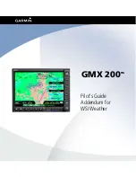
Garmin GMX 200 Скачать руководство пользователя страница 7

190-00607-06 Rev D

WSI Addendum

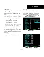
WSI - FIS

Menu Options for Overlay Page 1

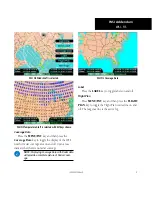
WSI FIS Graphic Weather Overlay Menu Items (Page 1)

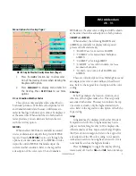
1.   Press  the 

Ovrl

  function  key  to  allow  selec-

tion of the Overlay choices when viewing the 
Graphical WX option. 

.   Press 

Menu/enT

  to  display  menu  items  for 

the  Overlay.  Press 

neXT  PaGe

  to  see  more 

options. 

uS or Canadian Weather radar

This option is only available when subscribed to 

both radar products. WSI offers subscriptions for US 
and Canadian radar data. Because of differences in 
radar technology, both data types cannot be displayed 
at the same time. When subscribed to both weather 
radar products, you can alternate between the two 
with the Overlay option. 

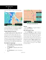
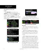
MeTars

When enabled, METARs are available as colored 

circles or diamonds at airports that provide METAR 
reports. Press the 

MetARs

 key to cycle through the 

options of circular, diamond, or no METARs. Circles 
depict the current METAR. Diamonds depict the 
current weather condition. Refer to the Legend for 
a description of the color code. US and Canadian 

METARS use the same color coding and will be shown 
at the same time with a subscription to both products. 

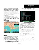
SIGMeTs & aIrMeTs

When enabled, the following SIGMETs and 

AIRMETs are available for display with repeated 
presses of the Menu Item key :

• 

“SIGMETs” are for Convective SIGMETs

• 

“T AIRMET” is for Surface/Aloft Turbulence 
AIRMETs

• 

“Z AIRMET” is for Icing AIRMET

• 

“S AIRMET” is for an IFR condition, such as a 
mountain obstruction

• 

“No Warn. Area” turns off all SIGMETs and 
AIRMETs

These are collectively known as Warning Boxes and 

are displayed as color coded outlines of the affected 
area. Refer to the Legend for a description of the color 
coding. 

echo Tops

Echo Tops indicate the location, elevation, and 

direction of the highest radar echo. This is typically 
associated with storms. This may not indicate the top 
of a storm or clouds, only the highest radar return 
echo. Refer to the Legend for a description of the Echo 
Tops coding. 

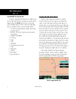
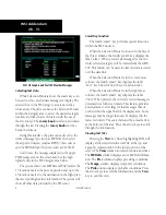
Icing

Icing data may be displayed with either Winds or 

Temperatures Aloft. Two icing hazards may be dis-
played. Current Icing Severity (CIS) is displayed in 
different shades of blue. Super-cooled Large Droplets 
(SLD) are shown in magenta. Refer to the Legend for 
a description of the CIS color coding. A dot pattern 
indicates areas where no icing has been received or is 
not available, such as the higher altitudes. 

Press the 

Icing

 key to toggle the display of Icing 

data on and off. Use the 

Alt+

 and 

Alt-

 menu item keys 

Содержание GMX 200

Страница 1: ...GMX 200TM Pilot s Guide Addendum for WSI Weather...

Страница 2: ...own load a single copy of this manual onto a hard drive or other electronic storage medium to be viewed and to print one copy of this manual or of any revision hereto provided that such electronic or...

Страница 3: ...3 190 00607 06 Rev B July 2007 2 12 190 00607 06 Rev C September 2007 2 12 190 00607 06 Rev D Ordering Information To receive additional copies of this GMX 200 Pilot s Guide Addendum for WSI Weather o...

Страница 4: ...ETARs 3 SIGMETs AIRMETs 3 Echo Tops 3 Icing 3 Temporary Flight Restrictions TFRs 4 Menu Options for Overlay Page 2 4 Lightning 4 Winds and Temperatures Aloft 4 Coverage Data 5 Label 5 Flight Plan 5 Me...

Страница 5: ...nd Sigmets Times are Zulu times when the data was assembled on the ground not the time the data was received by the FIS sensor For GMX 200s that have a GPS receiver that provides time the Zulu time is...

Страница 6: ...ere no data has been received from the FIS sensor Solid cyan areas represent areas where the ground based weather radars are unable to monitor weather This is typically caused by terrain obstruction W...

Страница 7: ...products SIGMETs AIRMETs When enabled the following SIGMETs and AIRMETs are available for display with repeated presses of the Menu Item key SIGMETs are for Convective SIGMETs T AIRMET is for Surface...

Страница 8: ...are enabled in the MAP function Menu Options for Overlay Page 2 1 Press the Ovrl function key to allow selec tion of the Overlay choices when viewing the Graphical WX option 2 Press Menu Ent to displa...

Страница 9: ...of the WSI weather radar coverage area on and off Cyan areas indicate that there is no radar coverage NOTE Displaying Coverage Data with Radar data will provide a complete picture of Radar Cover age...

Страница 10: ...m key to choose between the display of No Overlays the Base Map or Map and Nav Aids SafeTaxi airport diagrams are always drawn if available in the database SafeTaxi airport diagrams are drawn when the...

Страница 11: ...ation time and message body 1 Press the Menu Ent key and then press the Text key to activate the Text display 2 Use the function arrow keys to select the FIS Cat egory and information type When availa...

Страница 12: ...S Function When the Selection Pointer is located in the first of the three columns the fourth smart key displays the label Clear When pressed all messages for the cur rently selected category will be...

Страница 13: ...sen airport that matches the location field of the received message If this lookup is success ful a distance shall be presented adjacent to the location text If no corresponding location can be determ...

Страница 14: ...dicators that provide specific operational guidance i e go or no go There is no specific action to be taken by the flight crew based on the displayed code Codes are an indication that the unit may hav...

Страница 15: ......
Страница 16: ...t Olathe Kansas 66062 U S A Garmin AT Inc 2345 Turner Rd S E Salem Oregon 97302 U S A Garmin Europe Ltd Liberty House Hounsdown Business Park Southhampton SO40 9RB U K Garmin Corporation No 68 Jangshu...

Отзывы: