background image

 2.5 

System setup

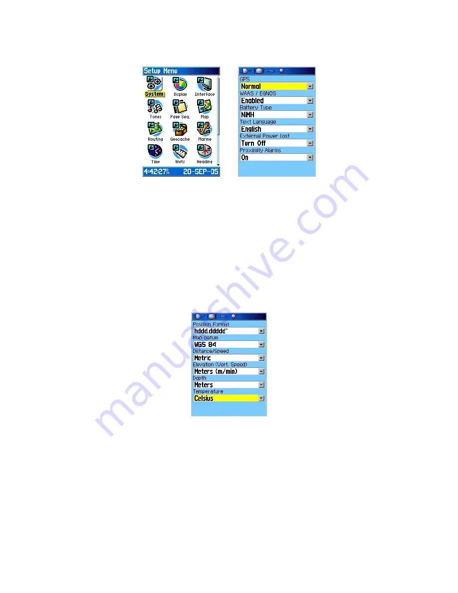
System Setup

Press 

Menu

 twice or 

Page

 key until you arrive to the 

Main Menu

Select the 

Setup

 icon, and press 

Enter

, then select the 

System

 icon, and press 

Enter

Highlight 

GPS

, press 

Enter

, select 

Normal

, and press 

Enter

 again

Highlight 

WASS/EGNOS

, press 

Enter

, select 

Enabled

, and press 

Enter

 again

Highlight 

Battery Type

, press 

Enter

, select depending on your battery type (most rechargeable 

batteries are usually 

NiMH

, while the normal ones are 

Alkaline

)  

 2.6 

Units Setup

Units Setup

To set up Measuring Units:

Press 

Menu

 twice or 

Page

 key until you arrive to the 

Main Menu

Select 

Setup

 icon, press 

Enter

, then select the 

Units

 icon, and press 

Enter


Highlight 

Position Format

, press 

Enter

, select 

hddd.ddddd

°

, and press 

Enter


Select 

Map Datum

, press 

Enter

, select 

WGS 84

, and press 

Enter

Select 

Distance/Speed

, press 

Enter

, select 

Metric

, and press 

Enter

Select 

Elevation

, press 

Enter

, select 

Meters (m/min)

, and press 

Enter

Select 

Depth

, press 

Enter

, select 

Meters

, and press 

Enter

Select 

Temperature

, press 

Enter

, select 

Celsius

, and press 

Enter

Содержание eTrex - Hiking GPS Receiver

Страница 1: ...rtment of Defense in 1973 1 2 How it works The Global Positioning System consists of three segments 1 Space Segment The space segment is composed of orbiting satellites positioned in medium Earth orbi...

Страница 2: ...Trex operates on two AA batteries which are not included To install the batteries Remove the battery compartment cover from the back of the unit Insert the batteries observing the proper polarity The...

Страница 3: ...the USB unit on the back of the unit Connect the USB cable to the USB port on your computer and the USB port on the back of the unit Transfer the data Installing the batteries and a microSD card 2 1 3...

Страница 4: ...s for a large number of countries Download a map To find maps of the area load http downloads cloudmade com and browse the maps The Garmin maps are in img format Once the area of interest is found dow...

Страница 5: ...ht Lock On Road press Enter select Off and press Enter again Turning Lock On Road ON would automatically align the tracklog with the nearest road present on the map loaded into the GPS unit By turning...

Страница 6: ...ack Log is set to Off move the Rocker to highlight On and press Enter Next configure the Track Log recording Highlight the Setup button and press Enter to open the Tracklog Setup Page Highlight Wrap W...

Страница 7: ...sually NiMH while the normal ones are Alkaline 2 6 Units Setup Units Setup To set up Measuring Units Press Menu twice or Page key until you arrive to the Main Menu Select Setup icon press Enter then s...

Страница 8: ...r and select a city in your time zone If no obvious choice is listed select Other and press Enter Highlight UTC Offset press enter and use the Numeric Keypad to manually set your timezones offset When...

Страница 9: ...vice on by pressing the Power button GPS is now searching for the satellite signals The Locating Satellites is replaced by Acquiring Satellites message Once the connection is established the Location...

Страница 10: ...piece of paper or into Waypoint Log Sheet the number and the name of the point you are collecting You can move up to the waypoint number field by using the Rocker key and press Enter Alphanumeric and...

Страница 11: ...ys 3 4 Collecting Areas An area is an enclosed space usually of the same attribute land use Areas can be forests lakes seas parks fields buildings parking lots squares playgrounds etc There is a coupl...

Страница 12: ...the middle of an area and sketching out an area Collecting a point in the middle and sketching out an area Collecting points on the perimeter of the area Walking the perimeter of an area and collectin...

Отзывы: