background image

Select 

Settings

 > 

Navigation

 > 

Calculation Mode

.

• Select 

Faster Time

 to calculate routes that are faster to 

drive but can be longer in distance.

• Select 

Shorter Distance

 to calculate routes that are 

shorter in distance but can take more time to drive.

• Select 

Off Road

 to calculate point-to-point routes (without 

roads).

Previewing Multiple Routes

1

Search for a location (

page 3

).

2

From the search results, select a location.

3

Select 

Routes

.

4

Select a route.

5

Select 

Go!

.

Starting a Route to a Saved Location

1

Select 

Where To?

 > 

Saved

.

2

If necessary, select a category, or select 

All Saved Places

.

3

Select a location.

4

Select 

Go!

.

Your Route on the Map

NOTICE

The speed limit feature is for information only and does not 

replace your responsibility to abide by all posted speed limit 

signs and to use safe driving judgment at all times. Garmin will 

not be responsible for any traffic fines or citations you receive 

for failing to follow all applicable traffic laws and signs.

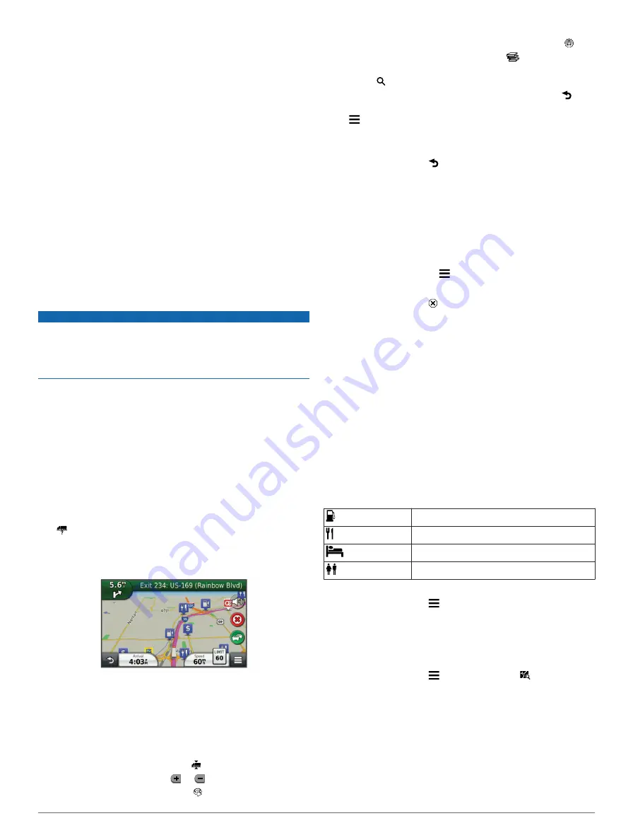
The route is marked with a magenta line. A checkered flag 

marks your destination.
As you travel, the device guides you to the destination with 

voice prompts, arrows on the map, and directions at the top of 

the map. If you depart from the original route, the device 

recalculates the route and provides new directions.
An icon displaying the current speed limit may appear as you 

travel on major roadways.
Truck speed limits may appear when you are driving in Truck 

mode based on truck configuration data and applicable laws for 

the state or province.
When you are driving in Truck or RV mode, a tone may sound 

and   may appear, indicating that truck suitability for this 

roadway is unknown. Always obey posted signs and 

regulations.

NOTE: 

Truck speed limits are not available for all areas.

Using the Navigation Map

1

From the main menu, select 

View Map

.

2

If the zoom controls are hidden, select the map to display the 

zoom controls.

3

Select the map.

4

Select an option:
• To view trucking alerts, select  .
• To zoom in or out, select   or  .
• To rotate the map view, select  .

• To switch between North Up and 3-D views, select  .
• To add or remove map layers, select 

.

• To view specific categories when not navigating a route, 

select  .

• To center the map on your current location, select  .
• To view shortcuts for map and navigation features, select 

.

Adding a Point to a Route

Before you can add a stop, you must be navigating a route.

1

From the map, select   > 

Where To?

.

2

Search for the extra stop.

3

Select the stop from the search results.

4

Select 

Go!

.

5

Select 

Add to Active Route

.

Taking a Detour

While navigating a route, you can use detours to avoid 

obstacles ahead of you, such as construction zones.

While navigating, select   > 

Detour

.

Stopping the Route

From the map, select  .

Using Suggested Routes

Before you can use this feature, you must save at least one 

location and enable the travel history feature (

page 18

).

Using the myTrends™ feature, your device predicts your 

destination based on your travel history, the day of the week, 

and the time of day. After you have driven to a saved location 

several times, the location may appear in the navigation bar on 

the map, along with the estimated time of travel, and traffic 

information.

Select the navigation bar to view a suggested route to the 

location.

About Exit Services

While you navigate a route, you can find gas, food, lodging, and 

restrooms near upcoming exits.
Services are listed under tabs by category.

Gas

Food

Lodging

Restrooms

Finding Exit Services

1

From the map, select   > 

Exit Services

.

2

Use the arrows to select an upcoming exit.

3

Select an exit service tab.

4

Select a point of interest.

Navigating to an Exit

1

From the map, select   > 

Exit Services

 >  .

2

Select 

Go!

.

Avoiding Road Features

1

Select 

Settings

 > 

Navigation

 > 

Avoidances

.

2

Select the road features to avoid on your routes, and select 

Save

.

6

Navigation

Содержание dezl 760LMT

Страница 1: ...dēzl 760 Owner s Manual November 2012 190 01511 00_0A Printed in Taiwan ...

Страница 2: ...rademarks of Garmin Ltd or its subsidiaries registered in the USA and other countries BaseCamp dēzl ecoRoute HomePort myGarmin myTrends nüMaps Guarantee nüMaps Lifetime and trafficTrends are trademarks of Garmin Ltd or its subsidiaries These trademarks may not be used without the express permission of Garmin The Bluetooth word mark and logos are owned by the Bluetooth SIG Inc and any use of such n...

Страница 3: ...igning Categories to a Saved Location 5 Sharing a Saved Location 5 Sending a Location to the Device 5 Deleting a Saved Location 5 Navigation 5 Starting a Route 5 Changing the Route Calculation Mode 5 Previewing Multiple Routes 6 Starting a Route to a Saved Location 6 Your Route on the Map 6 Using the Navigation Map 6 Adding a Point to a Route 6 Taking a Detour 6 Stopping the Route 6 Using Suggeste...

Страница 4: ...ons 14 Subscription Activation 14 Disabling Traffic 14 Trucking Features 14 About IFTA Logging 14 Entering Fuel Data 14 Editing Fuel Logs 14 Viewing and Exporting a Jurisdiction Summary 14 Editing and Exporting Trip Reports 15 Viewing Exported Jurisdiction Summaries and Trip Reports 15 About Hours of Service 15 Recording Your Duty Status 15 About Drivers 15 Using Driving Logs 15 Adding Shipments 1...

Страница 5: ...e does not appear as a removable drive on my computer 20 My device does not appear as a portable device on my computer 20 My device does not appear as either a portable device or a removable drive or volume on my computer 20 My phone will not connect to the device 20 Index 21 Table of Contents iii ...

Страница 6: ......

Страница 7: ...hboard page 1 2 Under Software Updates click Update Now 3 Follow the on screen instructions nüMaps Guarantee If you register the device at http my garmin com within 90 days of acquiring satellites while driving your device could be eligible for one free map update Go to www garmin com numaps for terms and conditions Updating Maps 1 Open myDashboard page 1 2 Register the device page 1 3 Select an o...

Страница 8: ...ns to change settings or view additional information GPS signal status Bluetooth technology status appears when Bluetooth is enabled Transportation mode indicator Current time Battery status Acquiring GPS Signals To navigate with your device you must acquire satellites in the status bar indicates the satellite signal strength see page 2 Acquiring satellites can take several minutes 1 Turn on the d...

Страница 9: ...ess page 4 Using recently found locations page 5 Using coordinates page 4 Using the map page 4 Using saved locations page 5 About Locations The detailed maps loaded in your device contain locations such as restaurants hotels and auto services You can use categories to browse for nearby businesses and attractions Finding a Location by Category 1 Select Where To 2 Select a category or select Categor...

Страница 10: ...ding an Intersection 1 Select Where To Categories Intersections 2 Select an option Select a state or province To change the country state or province select State or Country and enter a name 3 Enter the first street name and select Next 4 If necessary select the street 5 Enter the second street name and select Next 6 If necessary select the street 7 If necessary select the intersection Finding a C...

Страница 11: ...ange Map Symbol to change the symbol used to mark the saved location on a map 7 Edit the information 8 Select Done Assigning Categories to a Saved Location You can add custom categories to organize your saved locations NOTE Categories appear in the saved locations menu after you have saved more than 12 locations 1 Select Where To Saved 2 Select a location 3 Select 4 Select Edit Categories 5 Enter ...

Страница 12: ...n menu select View Map 2 If the zoom controls are hidden select the map to display the zoom controls 3 Select the map 4 Select an option To view trucking alerts select To zoom in or out select or To rotate the map view select To switch between North Up and 3 D views select To add or remove map layers select To view specific categories when not navigating a route select To center the map on your cu...

Страница 13: ...elect Calculation Mode Off Road Save The next route will be calculated as a straight line to the location Map Pages Customizing the Map Customizing the Map Layers You can customize which data appear on the map such as icons for points of interest and road conditions 1 From the map select 2 Select Map Layers 3 Select which layers you want to include on the map and select Save Viewing the Trip Log Y...

Страница 14: ...e Where Am I page to view information about your current location This feature is helpful if you need to tell emergency personnel your location From the map select Where Am I Finding Nearby Services You can use the Where Am I page to find nearby services such as hospitals or police stations 1 From the map select Where Am I 2 Select a category Getting Directions to Your Current Location If you need...

Страница 15: ...devices appears 6 Select your phone from the list and select OK 7 If necessary on your phone confirm that the device is allowed to connect 8 If necessary enter the device Bluetooth PIN into your phone Disconnecting Your Phone 1 Select Settings Bluetooth 2 Select Phone None Save Your phone is disconnected from your device but remains paired with your device Tips After Pairing the Devices After the ...

Страница 16: ...appears in the status bar on your device when Smartphone Link is connected Sending a Location from Your Phone to Your Device Smartphone Link is registered as a navigation application on your phone 1 From your phone select the button to start navigating to a location see the owner s manual for your phone 2 From the application menu select Smartphone Link The next time you connect your device to you...

Страница 17: ...formation 1 Select Apps ecoRoute Fuel Economy 2 Select a section of the graph to zoom in Mileage Reports Mileage reports provide the distance the time the average fuel economy and the fuel cost of navigating to a destination A mileage report is created for every route that you drive If you stop a route on your device a mileage report is created for the distance you traveled Viewing a Mileage Repor...

Страница 18: ...roll through the images 3 Select a picture Viewing a Slideshow 1 Select Apps Picture Viewer 2 Select 3 While a slideshow is playing select the screen to stop the slideshow Deleting Pictures 1 Select Apps Picture Viewer 2 Select a picture 3 Select Delete Yes Viewing Previous Routes and Destinations Before you can use this feature you must enable the travel history feature page 17 You can view your ...

Страница 19: ... information Before you can receive traffic data the traffic receiver and the device must be in data range of an FM station transmitting traffic information When the receiver is within a traffic coverage area your device will begin displaying traffic information 1 Connect the traffic receiver to an external power source 2 Connect the traffic receiver to the device Traffic Receiver À Mini USB conne...

Страница 20: ... countries 1 From the main menu select Traffic 2 Select Subscriptions 3 Write down the FM traffic receiver unit ID 4 Go to www garmin com fmtraffic to purchase a subscription and get a 25 character code The traffic subscription code cannot be reused You must obtain a new code each time you renew your service If you own multiple FM traffic receivers you must obtain a new code for each receiver 5 Se...

Страница 21: ...he time you are on duty but not driving a commercial motor vehicle Select Passenger Seat to record the time a second driver is in the passenger seat but is not on duty NOTE A driver can be in passenger seat status for up to two hours immediately after or before eight consecutive hours in the sleeper berth 5 Select Save About Drivers If you work for more than one carrier in a 24 hour period you mus...

Страница 22: ...e or as two removable drives representing the device and the memory card Transferring Data From Your Computer 1 Connect the device to your computer page 16 Your device and memory card appear as removable drives in My Computer in Windows and as mounted volumes on Mac computers NOTE Some computers with multiple network drives cannot display device drives See your operating system help file to learn ...

Страница 23: ...tes routes that could use less fuel than other routes Off Road Calculates a direct line from your location to your destination Display Settings To open the Display settings page from the main menu select Settings Display Color Mode Changes the brightness of the screen Decreasing the brightness can save battery power Display Timeout Sets the amount of idle time before your device enters sleep mode ...

Страница 24: ...s not guarantee that your vehicle s characteristics will be accounted for in all route suggestions or that you will receive the warning icons in all cases Limitations may exist in the map data such that your device cannot account for these restrictions or road conditions in all cases Always defer to all posted road signs and road conditions when making driving decisions Restriction Warnings Height...

Страница 25: ...the disk Removing the Device Cradle and Mount Removing the Device from the Cradle 1 Press the tab on the top of the cradle 2 Tilt the device forward Removing the Cradle from the Mount 1 Turn the cradle to the right or left 2 Apply pressure until the socket on the cradle releases the ball on the mount Removing the Suction Cup Mount from the Windshield 1 Flip the lever on the suction cup mount towar...

Страница 26: ... 3 with Windows Media Player 10 My device does not appear as a portable device on my computer On Mac computers and some Windows computers the device connects using USB mass storage mode In USB mass storage mode the device appears as a removable drive or volume and not as a portable device Windows versions prior to Windows XP Service Pack 3 use USB mass storage mode My device does not appear as eit...

Страница 27: ...sdiction summaries 14 trip reports 15 extras custom points of interest 19 safety cameras 19 F files supported types 16 transferring 16 finding locations 3 See also locations addresses 4 browsing the map 4 categories 3 cities 4 coordinates 4 intersections 4 using the map 4 fuel prices 11 fuel data entering 14 fuel economy 11 See also ecoRoute fuel logs 14 fuel price changing 11 fuse changing 19 G G...

Страница 28: ...ns 5 settings 17 18 shipments 15 adding 15 hours of service 15 shortcuts 3 adding 3 deleting 3 simulated locations 5 sleep mode 2 entering 2 exiting 2 Smartphone Link connecting 10 disabling calls 10 Garmin Live Services 10 software updating 1 version 18 speech recognition 8 stops adding 6 subscriptions Garmin Live Services 10 nüMaps Lifetime 1 traffic 1 suction cup 19 T theft avoiding 19 time set...

Страница 29: ......

Страница 30: ...39 02 3669 9699 0800 0233937 815 69 555 00800 4412 454 44 2380 662 915 00 35 1214 447 460 00 34 902 007 097 00 46 7744 52020 Garmin International Inc 1200 East 151st Street Olathe Kansas 66062 USA Garmin Europe Ltd Liberty House Hounsdown Business Park Southampton Hampshire SO40 9LR UK Garmin Corporation No 68 Zhangshu 2nd Road Xizhi Dist New Taipei City 221 Taiwan R O C 2012 Garmin Ltd or its sub...

Отзывы: