background image

2

Select  .

3

Open BaseCamp.
BaseCamp recognizes and transfers the collar's internal track 

log.

Deleting Files

NOTICE

If you do not know the purpose of a file, do not delete it. Your 

device memory contains important system files that should not 

be deleted.

1

Open the 

Garmin

 drive or volume.

2

If necessary, open a folder or volume.

3

Select a file.

4

Press the 

Delete

 key on your keyboard.

Disconnecting the USB Cable

If your device is connected to your computer as a removable 

drive or volume, you must safely disconnect your device from 

your computer to avoid data loss. If your device is connected to 

your Windows computer as a portable device, it is not necessary 

to safely disconnect.

1

Complete an action:
• For Windows computers, select the 

Safely Remove 

Hardware

 icon in the system tray, and select your device.

• For Mac computers, drag the volume icon to the trash.

2

Disconnect the cable from your computer.

Appendix

Accessories and Replacement Parts

Purchasing Accessories

Go to 

http://buy.garmin.com

.

Optional Maps

You can use additional maps with the device, such as BirdsEye 

satellite imagery, BlueChart

®

 g2, and City Navigator

®

 detailed 

maps. Detailed maps may contain additional points of interest, 

such as restaurants or marine services. For more information, 

go to 

http://buy.garmin.com

 or contact your Garmin dealer.

ANT+ Sensors

Your device can be used with wireless ANT+ sensors. For more 

information about compatibility and purchasing optional sensors, 

go to 

http://buy.garmin.com

.

tempe

The tempe is an ANT+ wireless temperature sensor. You can 

attach the sensor to a secure strap or loop where it is exposed 

to ambient air, and therefore, provides a consistent source of 

accurate temperature data. You must pair the tempe with your 

device to display temperature data from the tempe.

Using Optional Fitness Accessories

1

Bring the device within range 10 feet (3 m) of the ANT+ 

accessory.

2

Select 

Setup

 > 

ANT Sensors

.

3

Select 

Heart Rate Monitor

Bike Cadence Sensor

, or 

tempe Sensor

.

4

Select 

On

Off

, or 

Search for New

.

5

Customize the data fields to view the heart rate or cadence 

data (

Customizing the Data Fields

, page 11

).

Tips for Pairing ANT+ Accessories with Your Garmin Device

• Verify that the ANT+ accessory is compatible with your 

Garmin device.

• Before you pair the ANT+ accessory with your Garmin 

device, move 10 m (32.9 ft.) away from other ANT+ 

accessories.

• Bring the Garmin device within range 3 m (10 ft.) of the ANT+ 

accessory.

• After you pair the first time, your Garmin device automatically 

recognizes the ANT+ accessory each time it is activated. This 

process occurs automatically when you turn on the Garmin 

device and only takes a few seconds when the accessories 

are activated and functioning correctly.

• When paired, your Garmin device receives data from only 

your accessory, and you can go near other accessories.

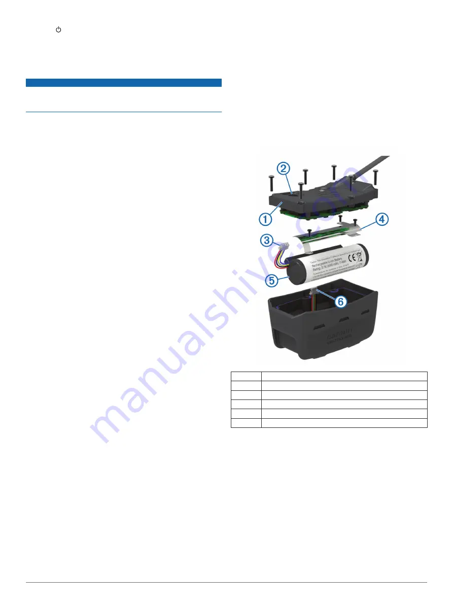
T5 Battery Replacement Instructions

T5 Components

À

Back plate

Á

Power key

Â

Battery connector

Ã

Battery cover

Ä

Battery

Å

Power connector

Removing the Old Battery

Before you replace the battery, you must remove all dirt, water, 

and debris from the device. You must also have a small Phillips 

screwdriver.

1

Remove the six screws from the outer edges of the back 

plate.

NOTE: 

You should leave the two inner screws in place.

2

Pry off the back plate.

3

Disconnect the battery connector and power connector.

4

Remove the screws that secure the battery cover.

5

Remove the battery cover and the battery.
Remember the orientation of the battery. You must install the 

new battery the same way.

After you remove the old battery, contact your local waste 

disposal department to properly recycle the battery.

16

Appendix

Содержание Alpha 100 T5

Страница 1: ...Alpha 100 with T5 T5 mini Owner s Manual July 2015 Printed in Taiwan 190 01771 00_0B ...

Страница 2: ...rmin the Garmin logo Alpha ANT BlueChart City Navigator and VIRB are trademarks of Garmin Ltd or its subsidiaries registered in the USA and other countries BaseCamp Garmin Express and tempe are trademarks of Garmin Ltd or its subsidiaries These trademarks may not be used without the express permission of Garmin microSD and the microSDHC logo are trademarks of SD 3C LLC Windows and Windows NT are r...

Страница 3: ...racking a Contact 7 Finding Your Contact ID 7 Changing Your Contact ID 7 Updating a Contact ID 7 Hunting with the Alpha System 7 Marking Your Truck Location 7 Marking a Covey 7 Turning On the Collar Light 7 Turning On Rescue Mode 7 Waypoints Routes and Tracks 7 Waypoints 7 Marking Your Current Location 7 Marking a Waypoint Using the Map 7 Editing a Waypoint 8 Repositioning a Waypoint to Your Curre...

Страница 4: ...ating the Software 13 Device Care 13 Cleaning the Device 13 Cleaning the Touchscreen 14 Specifications 14 Alpha 100 Handheld Device Specifications 14 T5 Dog Collar Device Specifications 14 T5 mini Dog Collar Device Specifications 14 Battery Information 14 Long Term Storage 14 Maximizing the Battery Life 14 Saving Energy While Charging the Device 15 Data Management 15 File Types 15 Installing a Mem...

Страница 5: ... Æ Battery cover D ring Ç Mini USB port under weather cap Dog Collar Device NOTE Your dog collar device may look different than the device pictured À VHF antenna Á GPS antenna  Power key à Status LED and flashing beacon LEDs Getting More Information You can find more information about this product on the Garmin website Go to www garmin com alpha Go to www garmin com outdoor Go to www garmin com l...

Страница 6: ...ea 2 Turn on both devices Turning On the Devices page 2 3 Select the power key on the handheld device shows the GPS signal strength When the collar has acquired satellite signals the status LED flashes a double blink or triple blink in green Using the Touchscreen Select to open the application drawer Select to open a menu Select to close the page and return to the previous page If you are more tha...

Страница 7: ...to add or you cannot put the collar into pairing mode you can add the dog using the track and train codes 1 Select Add Dog 2 When asked if you are near the collar select No 3 When asked if you know the track and train codes select Yes 4 Enter the track or train code for the collar and select The dog s track code allows you to track the dog The dog s train code allows you to both track and train th...

Страница 8: ...s not too tight 4 If the strap is too long cut off the excess leaving at least 3 in 7 62 cm to spare Enabling Bark Detection NOTE This feature is not available in all areas Select Setup Dogs Bark Detection A barking icon appears on the dog tracking page and the map page When the dog collar device is active and properly fitted on the dog Fitting the Collar on Your Dog page 4 it detects barks automa...

Страница 9: ...n com basecamp The BaseStation feature of BaseCamp allows you to track your dogs and contacts in real time on a computer For more information on using BaseCamp see the help file in the application 1 Select Setup System BaseCamp BaseStation Prompted 2 Open BaseCamp 3 Follow the on screen instructions Pausing Dog Tracking You can pause the tracking of a single dog during a hunt This can be helpful i...

Страница 10: ...og you must add a dog to the handheld device Adding a Dog Using Wireless Pairing page 3 You can assign a specific dog training method to each training key You can add multiple pages of training key settings This mode is most useful when training multiple dogs 1 Select Setup Training Training Buttons Change Mode 2 Select below the key you are customizing 3 Select the dog to train with this key 4 Se...

Страница 11: ...ruck Location page 7 Track your dogs Tracking Your Dog on the Map page 4 Track your fellow hunters Tracking a Contact page 7 Mark the location of a covey Marking a Covey page 7 Send messages to your fellow hunters Sending a Message to Your Contacts page 7 Turn on the collar light Turning On the Collar Light page 7 Put the collar into rescue mode to save battery power Turning On Rescue Mode page 7 ...

Страница 12: ...lete Yes Routes A route is a sequence of waypoints or locations that leads you to your final destination Creating a Route 1 Select Route Planner Create Route Select First Point 2 Select a category 3 Select the first point on the route 4 Select Use Select Next Point 5 Select a point 6 Repeat steps 3 through 6 to add all the points in the route Editing the Name of a Route 1 Select Route Planner 2 Se...

Страница 13: ...mation bar along the top of the screen 6 Select 7 Select OK Clearing the Current Track Select Track Manager Current Track Clear Current Track Deleting a Track 1 Select Track Manager 2 Select a track 3 Select Delete Yes Archiving a Saved Track You can archive saved tracks to save memory space 1 Select Track Manager 2 Select a saved track 3 Select Archive Archiving Tracks Automatically 1 Select Setu...

Страница 14: ...ot displays the elevation for an elapsed time You can customize the plot Changing the Plot Type page 10 and the data fields Customizing the Data Fields page 11 To open the elevation plot select Elevation Plot Calibrating the Barometric Altimeter You can manually calibrate the barometric altimeter if you know the correct elevation or the correct barometric pressure 1 Go to a location where the elev...

Страница 15: ...d stop recording video select REC To take a photo select Controlling a VIRB Action Camera with Your Dog Collar Device Before you can use the VIRB remote function on your handheld device you must enable the remote setting on your VIRB camera See the owner s manual for your VIRB camera for more information 1 Turn on your VIRB camera 2 On the handheld device select Dog List 3 Select the dog wearing t...

Страница 16: ...otive perspective with the direction of travel at the top Guidance Text Sets when the guidance text on the map is shown Dashboard Sets a dashboard to display on the map Each dashboard shows different information about your route or your location Map Information Enables or disables the maps currently loaded on the device Map Speed Adjusts the speed at which the map is drawn A faster map drawing spe...

Страница 17: ...ettings Select Setup Marine Marine Chart Mode Sets the type of chart the device uses Nautical displays various map features in different colors so the marine POIs are more readable and so the map reflects the drawing scheme of paper charts Fishing requires marine maps displays a detailed view of bottom contours and depth soundings and simplifies map presentation for optimal use while fishing Appea...

Страница 18: ...ium ion batteries can be accelerated by exposure to elevated temperatures Storing a fully charged device in a location with a temperature outside the long term storage temperature range can significantly reduce its recharging capacity When you do not plan to use the handheld device for several months the battery should be removed Stored data is not lost when the battery is removed When you do not ...

Страница 19: ...rip_planning JPEG photo files GPX geocache files Go to www geocaching com play GPI custom POI files from the Garmin POI Loader Go to www garmin com products poiloader Installing a Memory Card WARNING Do not use a sharp object to remove user replaceable batteries You can install a microSD memory card in the handheld device for additional storage or pre loaded maps 1 Turn the D ring counter clockwis...

Страница 20: ...r the tempe with your device to display temperature data from the tempe Using Optional Fitness Accessories 1 Bring the device within range 10 feet 3 m of the ANT accessory 2 Select Setup ANT Sensors 3 Select Heart Rate Monitor Bike Cadence Sensor or tempe Sensor 4 Select On Off or Search for New 5 Customize the data fields to view the heart rate or cadence data Customizing the Data Fields page 11 ...

Страница 21: ...the battery plate 8 Remove the battery plate 9 Remove the battery The battery fits tightly It may be necessary to pry the battery out of the back plate using a non sharp non metal object 10Install the new battery into the front enclosure with the label side of the battery facing up and the leading edge of the battery placed under the charging contact ledge of the device 11Replace the battery plate...

Страница 22: ... Average The average vertical distance of descent since the last reset Descent Maximum The maximum rate of descent in feet per minute or meters per minute since the last reset Descent Total The total elevation distance descended since the last reset Distance to Destination The remaining distance to the final destination You must be navigating for this data to appear Distance to Next The remaining ...

Страница 23: ...ip Time Moving A running tally of the time spent moving since the last reset Trip Time Stopped A running tally of the time spent not moving since the last reset Trip Time Total A running tally of the total time spent moving and not moving since the last reset Turn The angle of difference in degrees between the bearing to your destination and your current course L means turn left R means turn right...

Страница 24: ...raining 6 L line of sight radio communication 4 locking screen 2 M main menu customizing 11 maps 7 9 data fields 11 measuring distances 9 navigation 9 optional 16 orientation 9 12 settings 12 13 15 updating 13 zoom 4 12 marine alarms setup 13 measuring distances 9 memory card 1 15 messages 7 microSD card See memory card MicroSD card See memory card N navigation 5 9 10 altimeter 10 O on screen butt...

Страница 25: ......

Страница 26: ...55 69 33 99 39 02 36 699699 52 001 855 792 7671 0800 0233937 47 815 69 555 00800 4412 454 44 2380 662 915 35 1214 447 460 386 4 27 92 500 0861 GARMIN 427 646 27 0 11 251 9999 34 93 275 44 97 46 7744 52020 886 2 2642 9199 ext 2 0808 238 0000 44 0 870 8501242 49 0 89 858364880 zum Ortstarif Mobilfunk kann abweichen 913 397 8200 1 800 800 1020 2014 Garmin Ltd or its subsidiaries ...

Отзывы: