


Garmin aera 795/796 Pilot’s Guide
190-01194-00 Rev. A
Appendix C
138
Overview
GPS Navigation
Flight Planning
Hazar
d A
voidance
Additional F
eatur
es
Appendices
Index
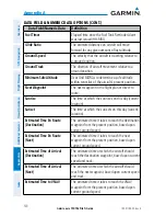
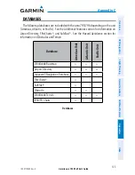
• Intersections—identifier, nearest VOR, radial and distance from nearest VOR,
location (latitude/longitude), and region/country.
• ARTCC—Air Route Traffic Control Centers.
• Airspace—boundaries (Class B, Class C, Control Zones, SUAs, and MOAs),
controlling agency, and vertical boundaries.
• FSS—Flight Service Stations.
* Symbology used for NDBs, VORs, and airports is consistent with those used on a
sectional chart.
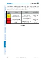
NOTE:
After performing a Jeppesen database update, verify all flight plan
(routes) are current. If there is an obsolete Jeppesen aviation point in a saved
route, the route is locked and unusable. A new route with current Jeppesen
database points will need to be created.
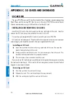
c
hArt
V
IeW
ChartView database is revised every 14 days. Charts are still viewable during a
period that extends from the cycle expiration date to the disables date. ChartView is
disabled 70 days after the expiration date and is no longer available for viewing.
ChartView data is downloaded from Jeppesen
®
onto an SD card.
Содержание aera 796
Страница 1: ...models 795 and 796 Pilot s Guide...
Страница 2: ......
Страница 3: ...OVERVIEW GPS NAVIGATION FLIGHT PLANNING HAZARD AVOIDANCE ADDITIONAL FEATURES APPENDICES INDEX...
Страница 4: ......
Страница 10: ...Garmin aera 795 796 Pilot s Guide 190 01194 00 Rev A Blank Page...
Страница 209: ......