background image


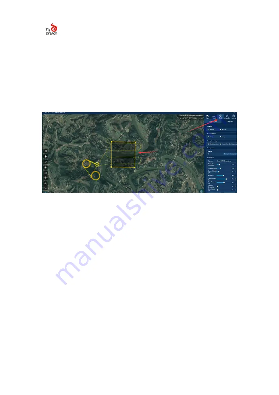
Click the aerial survey tab on the right, a shaded polygon area can be seen in the 

map  display area of the  ground station, click  and  drag the shaded  area to the 

desired  aerial  survey  position,  click  the  edge  of  the  polygon  to  increase  the 

vertices of the polygon, and adjust by dragging the vertices of the polygon The 

scope and shape of the aerial survey area. 


 hint: 

If the shadow area is not displayed in the map area after clicking the aerial survey 

tab, you can right-click on the map area and select "Replace the survey zone here". 

Method 2:

 Import the KML file to generate the operation area If the aerial survey 

area has been planned on the Google Earth software, you can directly import the 

KML file at the ground station to generate the operation area. Specific operation: 

Click the "UAV" menu bar, click "Import KML of survey area", select the KML file, 

the map area will display the KML overlay area, right-click in the area and select 

"Create aerial survey area from this KML file" to create an aerial survey area . 

Delete KML: Right-click on the KML area and "delete this KML area" to delete the 

KML area. 

Содержание FDG30

Страница 1: ...FDG30 Mako Shark mapping survey VTOL UAV User Manual V1 0 CHENGDU FLYDRAGON AVIATION TECH CO LTD...

Страница 2: ...act us for relevant technical consultation and training Disclaimer Before using this product please read this manual carefully The information data illustrations etc contained in this manual only repr...

Страница 3: ...algorithms the FDG30 Mako Shar can accurately map a region of 65 km at a scale of 1 500 270 km at a scale of 1 2000 Mapping highway corridors and surveying open pit mines are now within reach in a sin...

Страница 4: ...ch as an oblique camera for 3D modeling applications to address the most demanding mapping and topographic surveys The load bay design supports a wide range of sensors including orthophoto cameras hal...

Страница 5: ...r the aircraft self check Attention After the aircraft is assembled and the battery is connected the aircraft will automatically calibrate each sensor and the autopilot will detect it autonomously Do...

Страница 6: ...Click on Connect Drone...

Страница 7: ...V ground station before takeoff Green light flashes quickly The aircraft is unlocked successfully waiting for takeoff The VTOL drone will automatically take off after idling for 5 seconds hint If the...

Страница 8: ...tion Select Check in the control bar at the bottom of the ground station The ground station will pop up a check list window check in the order of the list and check the checked rows then click Next to...

Страница 9: ...ft by the flight instrument display on the flight tab on the right side of the ground station or the change of the indicator light of the aircraft when the status of the flight indicator flashes green...

Страница 10: ...t icon in the map area displays the flight airspeed altitude mode power and signal etc The small arrows and numerical values next to the aircraft icon indicate the wind direction and direction In addi...

Страница 11: ...he user is responsible for ensuring the flight safety of the drone Therefore it is necessary to keep monitoring the flight and landing of the drone to ensure that there are no obstacles in the landing...

Страница 12: ...he local topography urban layout and population density etc to provide a basis for the selection of take off and landing sites and route planning The following figure shows the UAV GCS aerial survey m...

Страница 13: ...ey tab you can right click on the map area and select Replace the survey zone here Method 2 Import the KML file to generate the operation area If the aerial survey area has been planned on the Google...

Страница 14: ...survey tab set the resolution flight height route angle and overlap rate according to the aerial survey requirements The flight altitude and the resolution affect each other The larger the ground dist...

Страница 15: ...terrain elevation data and adjust the minimum ground clearance of each route to the target flight height This function can ensure flight safety in areas with large height differences and avoid acciden...

Страница 16: ...to ensure that the aircraft has enough power to land safely without worrying about flight accidents due to insufficient power Introduction to terrain self checking function After the aerial survey tas...

Страница 17: ...Load task to load the aerial survey task and use it directly Suggest Pre store the map of the operation area in the ground station software in advance and save the route plan in the computer in advan...

Страница 18: ...above operation you can click the aerial survey tab on the right again drag the aerial survey shadow area and adjust the polygon shape same as above Set the aerial survey parameters same as above clic...

Страница 19: ...y mission planning A large area survey area can be directly planned as a task such as a survey area of 50 square kilometers one flight is planned and the planned operation time is 6 hours which can be...

Страница 20: ...uring the actual flight you can flexibly combine and load the independent survey areas into the same task The combined loading method is the same as above When loading multiple survey areas the ground...

Страница 21: ...e it needs to be supplemented between waypoint 5 and waypoint 11 you can right click waypoint 5 after takeoff and reach the take off circle point and click Fly to this waypoint the plane will immediat...

Страница 22: ...and the fan shape of 30 to the left and right must be an absolute clearance area 2 landing clearance requirements When entering the landing path there must be no obstacles within 15 meters to the lef...

Страница 23: ...the task synchronization mechanism of the ground station advanced function The tasks between the ground station and the aircraft will be automatically synchronized and any operations on the ground sta...

Страница 24: ...affecting flight safety 4 3Takeoff and landing settings 4 4 VTOL UAV take off After unlocking the drone will climb to 30 meters vertically after idling by default for 5 seconds can be set in the take...

Страница 25: ...o the take off circle point more smoothly it is recommended to set the take off circle point at 200 300 meters in the upwind direction of the take off point within distance Suggestion 1 The radius of...

Страница 26: ...nt for returning home and it is also the safe circling position when the aircraft is flying in an emergency Drag the landing circling point to set the landing direction 1 Fly to the landing circle poi...

Страница 27: ...s by default can be set the landing speed will be reduced to a slower speed default is 0 5m s can be set 6 After detecting reaching the ground the drone will automatically turn off the motor and lock...

Отзывы: