31
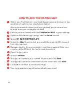
BATHYMETRIC MAPPING STEPS
Tether your FishHunter to your boat/kayak/canoe and ensure it
has good line of sight to your smartphone/tablet.
(We recommend the sonar be directly behind your boat and less
than 5ft from your smartphone/tablet.)
Ensure you are connected to the FishHunter Wi-Fi in your
settings.
Open the FishHunter app and go into the Sonar section.
Select MY BATHYMETRIC MAPS.
Select New Map.
The APP will validate your current GPS location and click Next.
The APP will double check the connection to your sonar and
click Next.
Click GO to start recording your map.
Your map will automatically save itself while it is recording and
can be found in MY BATHYMETRIC MAPS.
Visit our website for additional support videos:
www.fishhunter.com/support
1
2
3
4
5
6
7
8
9
Содержание DIRECTIONAL 3D
Страница 7: ...7 95 OF THE FISH ARE IN 5 OF THE WATER KNOW WHERE TO CAST...
Страница 11: ...11 11 1 Line of Sight 2 Good Elevation 3 No Obstructions BEST PRACTICES...
Страница 12: ...12 12 THE WORLD S ONLY PORTABLE FISH FINDER WITH 72 COVERAGE OF COVERAGE ANGLE 72 12...
Страница 16: ...16 16 DIRECTIONAL CASTING 16...
Страница 20: ...20 3D STRUCTURE MAPPING 20...
Страница 24: ...24 3D FISHING DEPTH TO BOTTOM DEPTH TO FISH 47 6 ft 44 ft 24...
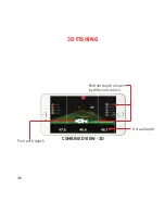
Страница 26: ...26 Bottom depth shown by different colors COMBINED VIEW 3D 3D FISHING Fish with depth Actual depth...
Страница 28: ...28 28 28...
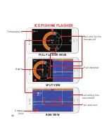
Страница 34: ...34 34 ICE FISHING FLASHER DEPTH TO BOTTOM 11 meters...

