


Field of View GeoSnap Basic Manual 17
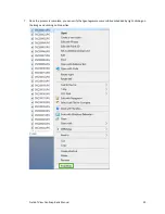
Settings Reviewed
Settings Reviewed
Description
If
“
Yes, I have reviewed these
settings”
is selected, blue and white
LED will no longer beep for 10sec
after booting. The objective of this
feature is to help prevent the
situation where you accidently fly a
mission with the wrong settings.
[Default value: No]
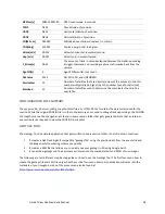
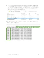
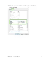
EVENTS FILE
The yyyy-mm-dd_hhmmss.txt Events File is a comma delimited text file that contains a log of the uncorrected
position data and other GNSS information for each event. You can view the file contents by opening it with a text
editor, such as Notepad.
The first line in the events file displays parameters such as system serial numbers, firmware version, receiver
information, and the X, Y, and Z offset values that were entered in the CONFIG file.
The data fields contained in the events file are described below:
Item
Sample Value
Description
Event
event_00001
Event number. Starts at event_00001 every time a new session starts
on the GeoSnap and increments by 1 for each image captured.
Lat[deg]
46.904083939
Latitude in decimal degrees
Lon[deg]
-96.811011085
Longitude in decimal degrees
Alt[WGS84-m]
258.305
Altitude above the WGS84 ellipsoid, in meters.
Omega[deg]
0
Omega angle, in degrees. This column is necessary for a Pix4D
compatible log. The value will always be zero as this data isn’t available.
Phi[deg]
0
Phi angle, in degrees. This column is necessary for a Pix4D compatible
log. The value will always be zero as this data isn’t available.
Kappa[deg]
-315.22
Kappa angle, in degrees. This column is necessary for a Pix4D
compatible log. The Kappa is generated by multiplying the Course Over
Ground by -1.
LatAccy[m]
1.241
The GNSS receiver’s estimate of horizontal accuracy (at the antenna).
LonAccy[m]
1.241
The GNSS receiver’s estimate of horizontal accuracy (at the antenna).
AltAccy[m]
1.636
The
GNSS receiver’s estimate of vertical accuracy (at the antenna).
GPSdate
2018-06-22
GPS date calculated from GPS week and time of week.
GPStime
17:20:55.391180
GPS time calculated from GPS week and time of week (this time is
different than UTC time because it does not take into account leap
seconds)
http://leapsecond.com/java/gpsclock.htm
SystemT [s]
126.759
GeoSnap system time. The time since the GeoSnap has been powered
on.
GPSweek
2006
GPS week.


