


DeX Operations Manual V. 2.1
Page 8
The
Direct To / Universal Finder
is a powerful way to
find navigable items in the Anywhere Map database.
The user may search for airports, navaids, fixes, and
user waypoints. Once a waypoint has been identified,
the user can easily create a
direct-to flight plan
, add
the waypoint to an existing flight plan, or view more
information about the item.
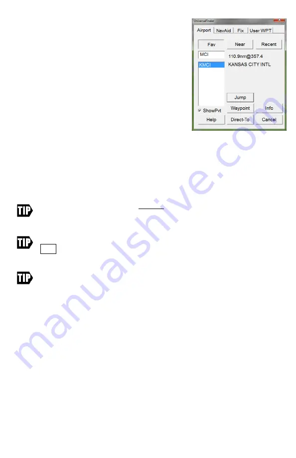
The
Selector tabs
across the top of the finder allow the
user to select the TYPE of waypoint being searched for.
Select the appropriate gray tab to search for an airport,
navaid, fix, or user waypoint.
Identifier box
: Tap in this box to enter the airport /
navaid identifier or fix / user waypoint name. When you tap in this box, the on-screen
keyboard will automatically appear. Use the on-screen keyboard for text entry if the
desired item does not appear in the Selection box located below the Entry box.
It is generally necessary to only enter the first letter or two of the identifier to find a
match. If you have entered an ambiguous identifier, you must tap on the desired match
in the list. You can tell when you have selected a waypoint, as the waypoint name and
range/bearing will appear.
When searching for an airport, DO NOT type in the regional prefix value. For
instance, to find Los Angeles International airport, enter
LAX
,
not
KLAX
. Not
entering the “K” prefix saves typing.
To hide the keyboard, tap on the airport you want in the list shown, or tap the
HIDE button on the keyboard, or press the physical keyboard button below
the tablet screen on the chassis of the tablet.
In Alaska, some airports in Alaska use “P” as the ICAO and others use “PA” as
the ICAO. Ted Stevens Anchorage (Whose Identifier with ICAO is PANC) would
be entered as ANC where as Juneau Intl (whose identifier with
ICAO
is PAJNU)
would be entered as AJN.
Fav / Nearby
: As the user enters partial identifiers in the “IDENTIFIER” box, the
finder will find close matches and list them in the box at the left. When FAV is
depressed, the close matches will be drawn from the stored list of previously viewed
waypoints; when NEARBY is depressed, the close matches will be chosen based on
proximity to the current map position.
Range/Bearing:
This box, to the right of the history/suggestion area, shows the
distance and bearing from your current position to the item you have highlighted in the
list box.
Detailed Info:
Opens the information screen for the waypoint selected.
Jump To:
This causes the map to be redrawn centered around the location of the
selected waypoint, overriding the GPS. The map will display “
GPS Disabled


