


DeX Operations Manual V. 2.1
Page 49
If you tap Done with an empty ident box, the plate screen will clear automatically. As
you enter the identifier, the auto-complete window will list probable matches for the
characters entered. Do not enter the ICAO ‘K’ when typing the identifier into the top
Left field. Complete the identifier or tap on the desired one from the auto-complete
window to view a list of the approaches for that airport.
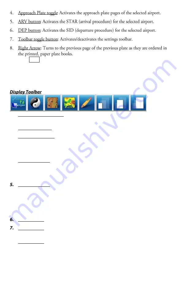
1.
Alternate Toolbar toggle: 2-way toggle between the Display Toolbar and the
Settings Toolbar.
2.
Night/Day Toggle: Changes the background color of the plate from white to black.
3.
Ultra TAWS toggle: Applies 90 meter Ultra TAWS data over the plan view of the
plate. This feature requires the Ultra TAWS Expansion pack for Anywhere Map
XP v2.1 or higher. This button will be grey if you do not have the expansion pack
installed/license key entered.
4.
NEXRAD toggle: Applies the current Nexrad image from Anywhere Map XP to be
displayed over the plan view of the plate. The age of the Nexrad file displays on
the bottom status bar of the application. This feature is only compatible with the
XM Satellite Weather Nexrad file. Anywhere Link Nexrad cannot be used.
Drawing Toolbar: Activates a ‘doodle’ feature making the plate image act like a
piece of scrDeXh paper. This toolbar now appears over the plate image. When the
toolbar is shown, you may write/draw on the plate. Click the eraser icon to clear
the entire ‘doodle’. To leave your ‘doodle’ visible and return to panning mode,
click the Drawing Toolbar icon again or click the X on the Drawing Toolbar to
close it. Now the pan mode is re-engaged.
Zoom Level 1: Fits the whole plate on the screen
Zoom Level 2: Fits the plate to the width of the screen. requires a small amount of
vertical panning to see the whole plate image.
8.
Zoom Level 3: Max Zoom


