background image

NX706AU

 English 27 

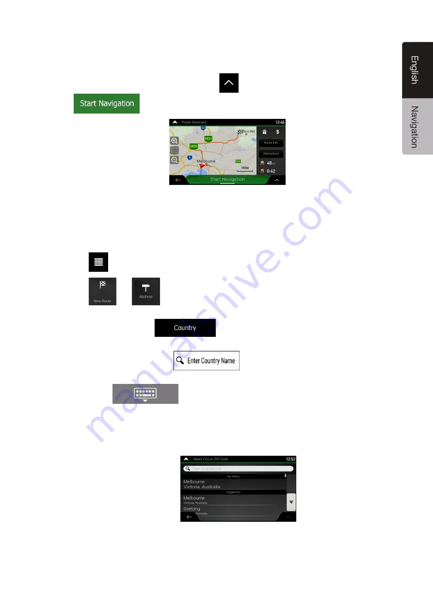
10. The route is calculated and the map appears showing the entire route, where you can check

route information and route alternatives. Tap 

 to modify the route parameters, or tap 

 to start your journey. 

3.1.2.2 Entering an address starting with the street name 

After you have selected the country and state, you can leave the city or ZIP code field empty and start 

the search with the street name. This way you can search in all streets of a state. If you select the 

country without a state, this function cannot work. 

1. Tap

 on the Navigation view to access the Navigation menu. 

2. Tap

 and 

 . 

3. By default, Clarion Navigation proposes the country and state where you are. If needed,

change the country. Tap 

.

a. In the Select Country screen, you can immediately select a country from the list below

the input field or tap the 

 button and start entering the first few 

letters of the country on the keyboard. 

b.

Tap

 to open the list of results and select one country from the list. 

4. If needed, select a new city.

a. Tap the City or ZIP code field.
b. (optional) In the Select City or ZIP code screen, you can immediately select a city from

the list of suggestions.

c. Otherwise, start entering the first few letters of the city on the keyboard. The names that

match the string appear in a list.

Содержание NX706AU

Страница 1: ...NX706AU Navigation Manual ADVANCED NAVIGATION ...

Страница 2: ...8 2 4 Navigation menu 18 3 Using the navigation 21 3 1 Selecting a destination 21 3 1 1 Using combined search 21 3 1 2 Selecting an address 24 3 1 2 1 Entering an address with states 24 3 1 2 2 Entering an address starting with the street name 27 3 1 2 3 Selecting a town centre 29 3 1 2 4 Selecting the midpoint of a street 30 3 1 2 5 Selecting an intersection in a town 31 3 1 2 6 Using the postcod...

Страница 3: ...ion 56 3 7 1 Switching to off road navigation 56 3 7 2 Selecting the destination in off road mode 56 3 7 3 Navigating in off road mode 56 4 Reference guide 57 4 1 Concepts 57 4 1 1 2D 3D GPS reception 57 4 1 2 Natural and TTS voices 57 4 1 3 Road safety cameras and other proximity Alert Points 57 4 1 4 Route calculation and recalculation 58 4 1 5 Smart Zoom 58 4 1 6 Speed limit warning 58 4 1 7 In...

Страница 4: ...nitor settings 71 4 3 8 Usage Reports settings 71 5 Troubleshooting 72 5 1 GPS signal cannot be received 72 5 2 Address cannot be found 72 5 3 The calculated route is not optimal 72 5 4 Disabling the speed limit warning 73 5 5 Keyboard buttons are greyed out 73 5 6 The map is hidden behind an image of a junction 74 6 Index 75 7 Copyright note 77 ...

Страница 5: ...ing the application The data are processed anonymously no one is able to track any personal information If you change your mind later you can enable or disable the log collection in Settings page 71 It is important to look at the display only when it is safe to do so If you are the driver of the vehicle we recommend that you plan and review your route before you start your journey Plan the route b...

Страница 6: ...ect your preferred language then tap to confirm your selection Later you can change it in Regional settings page 70 2 You are now asked whether you allow the software to collect usage information and GPS logs that may be used for improving the application and the quality of maps Tap to allow the anonymous statistics or disable this function Later you can turn them on or off individually in Usage r...

Страница 7: ...e 6 If needed modify the default route planning options Later you can change them in Route Preferences page 64 Tap to continue 7 The initial set up is now complete tap to enter the Navigation view 2 2 Screen controls The following sections describe the functionality and use of buttons sliders and other screen controls in Clarion Navigation ...

Страница 8: ...he location of the cursor can be used as the destination of the route or a new Alert Point You can also search for Places around it or add this location to your saved locations You can also select some of the objects on the map If you tap the map at the icon of a Place or traffic event the object is selected and you can get information about this object or use it as a route point 2 2 3 Using the k...

Страница 9: ...the keyboard entry Tap Starting a search for a keyboard entry Tap Hiding the keyboard Tap 2 2 4 Using touch gestures You usually need to tap the screen only once However some useful features can be accessed with other gestures See the table below Action Function Tapping and holding the screen Tap and keep pressing the following buttons to reach extra functions Tap and hold the following button on ...

Страница 10: ...ocation information No buttons The top section of the Navigation view shows information about the selected point the cursor Moving the map by dragging No buttons Move the map in any direction tap and hold the map and move your finger towards the direction you want to move the map Zooming in and out Change how much of the map is displayed on the screen Clarion Navigation uses maps that let you exam...

Страница 11: ...ing direction This is the default orientation in 3D map view mode In North up mode the map faces North Checking the compass The direction of the compass shows North Returning to normal navigation Move the map back to follow the current GPS position Automatic map rotation is also re enabled The map manipulation buttons disappear and the navigation continues Selecting additional options Open a list ...

Страница 12: ...ew displays the following screen buttons data fields and route information on the map during navigation Note Some buttons fields or icons may not be available in your product version Number Name Description 1 Current position marker The current position is displayed as a red arrow arrow by default When there is no GPS position the current position marker is transparent and it shows your last known...

Страница 13: ...pping it you can check the available parking facilities around your destination See page 60 9 Destination menu It appears near the destination By tapping it you can check the trip summary find Places around your final destination save the current location or suspend the navigation 12 Alert point warning It shows the type of the alert points when approaching a road safety camera or other Alert Poin...

Страница 14: ...igned to the direction of the road If you select off road navigation the current position marker is at your exact GPS position The direction of the icon shows your current heading 2 3 3 The planned route The planned route is the currently navigated route Whenever the destination is set the route is active until you delete it reach your destination or suspend navigation Clarion Navigation displays ...

Страница 15: ...information about the next route event manoeuvre and the next street or the next town There is a field in the top left corner displaying the next manoeuvre Both the type of the manoeuvre turn roundabout exiting motorway and so on and its distance from the current position are displayed A smaller icon shows the type of the second next manoeuvre if it is near the first one Otherwise only the next ma...

Страница 16: ...ll arrows at the bottom of the map Highlighted arrows represent the lanes and the direction you need to take Where additional information is available arrows are replaced by signposts Signposts are displayed at the top of the map The colour and style of the signposts are similar to the real ones you can see above roads or by roadsides They show the available destinations and the road numbers All s...

Страница 17: ...t available but the necessary information exists Generic Junction Views show a generic view of the junction focusing on the number and layout of lanes only The road signs are created from road shield road number and destination information received in the map data Junction view can be turned off in See page 68 2 3 8 Motorway services When you are driving on a motorway the button appears at the top...

Страница 18: ... are block representations of full town building data containing actual building sizes and positions on the map 2 4 Navigation menu On the Navigation view tap to open the Navigation menu You can see the following menu options when you are navigating without a planned route Button Function Select your destination by entering an address or its coordinate or by selecting a Place a Saved Location or a...

Страница 19: ...ation menu you have the following additional options Button Function Open the Saved Locations screen where you can save a location as a favourite destination or edit a saved location Switch to 2D 2D North up view or back to 3D mode Suspend navigation Resume navigation Access the User profiles menu where you can create new profiles or edit the existing ones If several drivers are using the navigati...

Страница 20: ...English Tap it to return to the map from any menu screen Tap the Back button to return to the previous screen You can also press and hold this button to quickly return to the Navigation view from any other screen ...

Страница 21: ...lecting a destination You can choose your destination by selecting one of the following options Using combined search to search among different destination types at once see page 21 Entering a full address or a part of an address for example a street name without a street number see page 24 Selecting a Place as your destination see page 32 Selecting a previously saved location as your destination ...

Страница 22: ...ly result appears below the input field as you enter new letters a If the new search area is in a different country or state start entering the country state and the town b Tap to see the whole list of the matching results 5 With the proper search area displayed start entering the name address or category of the destination you are looking for 6 Tap to switch to the result screen You can see all t...

Страница 23: ...ing the results from one provider only Look for the provider logos Tap one of them to see Places from that provider Tip To search for an intersection in the combined search enter the names of the streets connected by the sign You do not need to use spaces before and after the separator character For example you can find the intersection of Collins Street and Douglas Avenue by entering strings like...

Страница 24: ...ess including the street number see page 24 The address starting with the street name see page 27 The centre of a town see page 29 The midpoint of a street see page 30 An intersection see page 31 Any of the above starting the search with the postal code see page 32 3 1 2 1 Entering an address with states To enter an address as the destination follow these steps 1 Tap on the Navigation view to acce...

Страница 25: ...t a new city a Tap the City or ZIP code field b optional In the Select City or ZIP code screen you can immediately select a city from the list of suggestions c Otherwise start entering the first few letters of the city on the keyboard The names that match the string appear in a list d To open this list tap and select the city 5 Enter the street name a Tap the Street field b optional On the Select ...

Страница 26: ...keyboard To enter letters tap c Tap the selected address to finish the address search 7 A full screen map appears with the selected point in the middle If necessary tap the map somewhere else to modify the destination The cursor appears at the new location 8 Check the settings for road types and change them if necessary 9 Tap to confirm the destination You can also select a nearby point on the map...

Страница 27: ... the Navigation view to access the Navigation menu 2 Tap and 3 By default Clarion Navigation proposes the country and state where you are If needed change the country Tap a In the Select Country screen you can immediately select a country from the list below the input field or tap the button and start entering the first few letters of the country on the keyboard b Tap to open the list of results a...

Страница 28: ... c Otherwise start entering the street name on the keyboard the names that match the string appear in a list d Tap to open the list of results Select the street from the list 6 If available enter the street number by performing the following steps a Tap the Street number or crossing street field b Enter the street number on the keyboard To enter letters tap c Tap the selected address to finish the...

Страница 29: ...can check route information and route alternatives Tap to modify the route parameters or tap to start your journey 3 1 2 3 Selecting a town centre The town centre is not the geometric centre of the town but an arbitrary point the map creators have chosen In towns and villages it is usually the most important intersection and in larger towns it is one of the important intersections 1 Go to and modi...

Страница 30: ...f a street without entering the street number perform the following steps 1 Go to and select the country and town as described earlier The Select Street screen appears 2 Enter the street name by performing the following steps a Tap the Street name field b optional On the Select Street screen you can immediately select a street from the list of suggestions c Otherwise start entering the street name...

Страница 31: ...name by performing the following steps a Tap the Street name field b optional On the Select Street screen you can immediately select a street from the list of suggestions c Otherwise start entering the street name on the keyboard The names that match the string appear in a list d Tap to open the list of results Select the street from the list 3 Tap the Street number or crossing street field and br...

Страница 32: ...to open the numeric keypad b Start entering the postal code c Tap to open the list of results d Find the place you need 4 Continue the search as described previously page 24 3 1 3 Selecting a Place of Interest You can search for Places of Interest Places in the menu Using the same screen you can find a Place by selecting one of the following options Finding frequently searched types of Places with...

Страница 33: ...oute exists parking lots are searched around the destination If there is no planned route destination is not selected the search is carried out around the current position If the current position is not available either no GPS signal places are searched around the last known position 3 Tap any of the quick search buttons to get an instant list of Places 4 The Places in the list can be ordered by t...

Страница 34: ... the map or tap to select a different destination 11 The route is calculated and the map appears showing the entire route where you can check route information and route alternatives Tap to modify the route parameters or tap to start your journey 3 1 3 2 Searching by category To search for Places by their categories and subcategories perform the following steps 1 Tap on the Navigation view to acce...

Страница 35: ...ce from the destination Tap to search for a place within a selected town The result list is ordered by the distance from the centre of the selected town 5 optional If you have selected select the town to search in 6 Select one of the main Place categories for example Accommodation then browse the subcategories for example Hotel or Motel to find your destination 7 You can turn the Category View off...

Страница 36: ...o open the Search By Name or Category window 4 Select the area around which you would like to search for the Place By default the search area is around the current position or if it is not available around the last known position In this case the result list is ordered by the distance from this position Tap to select one of the following search areas Tap to search for a place within a selected tow...

Страница 37: ...entering the name of the Place or browse in the categories 2 After entering a few letters tap to open the list of Places or Place categories with names containing the entered character sequence 3 Browse the list if necessary and tap the desired list item A full screen map appears with the selected point in the middle The process continues the same way as in case of any other Places search See page...

Страница 38: ... Car repair and roadside assistance services Medical and emergency services Police stations Petrol stations 3 Tap any of the quick search buttons to get an instant list of those types of Places 4 optional The Places in the list can be ordered by the following criteria By their distance from the current or last known position By name Tap to reorder the list 5 Browse the list and tap one of the list...

Страница 39: ...browse the list to see more results 5 optional If needed tap to enable the editing option so that you can rename the saved locations or delete any of them 6 After you have selected a saved location as the destination a full screen map appears with the selected point in the middle 7 If necessary tap the map somewhere else to modify the destination The cursor appears in the new location 8 Check the ...

Страница 40: ... History item perform the following steps 1 Tap on the Navigation view to access the Navigation menu 2 Tap Two of the Smart History Items are displayed in the New Route to screen for easy access You can select one of them as your destination 3 To open all the history items tap The list of recent destinations appears The list begins with the three most likely destinations that are selected based on...

Страница 41: ... information and route alternatives Tap to modify the route parameters or tap to start your journey 3 1 6 Selecting a saved route The routes that you have saved earlier appear in a list To select a previous route perform the following steps 1 Tap on the Navigation view to access the Navigation menu 2 Tap and 3 The list of saved routes appears If necessary scroll the list to see earlier routes 4 Se...

Страница 42: ... the following steps 1 Tap on the Navigation view to access the Navigation menu 2 Tap and 3 You can enter the latitude and longitude values in any of the following formats decimal degrees degrees and decimal minutes or degrees minutes and decimal seconds Tap Tip optional If necessary tap then and enter the coordinate in UTM format 4 A full screen map appears with the selected point in the middle I...

Страница 43: ...to modify the route parameters or tap to start your journey 3 1 8 Selecting a location on the map To select a map location perform the following steps 1 Locate your destination on the map Move and scale the map as necessary 2 Tap the location that you want to select as your destination The cursor appears there 3 optional If needed tap to list the Places near the selected point or to save this loca...

Страница 44: ...t Route To build your route destination by destination perform the following steps 1 Tap on the Navigation view to access the Navigation menu 2 Tap 3 There is only one line in the list of route points the starting point of the route which is normally the current GPS position 4 Tap to select the destination 5 The New Route to screen appears where you can select the destination of the route the same...

Страница 45: ... route or the order of waypoints You can also delete all the destinations 9 When you have added all the route points tap and the planned route is automatically calculated 3 2 Checking Route Information and Alternatives To get a map overview of the planned route and check different parameters of the planned route perform the following steps 1 Tap on the Navigation view to access the Navigation menu...

Страница 46: ...nal actions for example edit your route preferences or display the itinerary 3 3 Editing the route When navigation has already started there are several ways to modify the planned route You have the following options Setting a new starting point see page 47 Adding an additional destination see page 48 Modifying the list of destinations see page 48 Saving the planned route see page 49 Deleting the ...

Страница 47: ...t GPS position 1 Tap on the Navigation view to access the Navigation menu 2 In the Navigation menu tap 3 The first line from the bottom is the start of the route normally the current GPS position Tap select and confirm your action at the warning message 4 The Change Start to screen appears Select the starting point of the route the same way you select a destination 5 You can see the new starting p...

Страница 48: ...us destination is deleted and a new route is calculated To add a new intermediate destination to the planned route perform one of the following actions Tap the map anywhere to browse it After selecting the location on the map tap and to add the selected location to your route as an intermediate destination The other destinations of the route remain intact Tap on the Navigation view and tap Add a d...

Страница 49: ...te with at least one intermediate destination you can delete the waypoint from the list right from the Main menu Tap then confirm the deletion 3 3 4 Saving the planned route To save the planned route perform the following steps 1 Select a destination as described earlier and tap 2 Tap and 3 Type in a name and tap 4 The route is saved and it is available in By selecting a previously saved route Cla...

Страница 50: ... confirmation If you have waypoints you can choose to delete the whole route or only the next waypoint 3 3 6 Selecting a route alternative when planning the route To select from different route alternatives or change the route planning method after you have selected a new destination perform the following steps 1 Select a destination as explained earlier and go to the route confirmation screen 2 T...

Страница 51: ... following steps 1 Tap on the Navigation view to access the Navigation menu 2 You can access the list of route alternatives from the Navigation menu in one of the following ways Tap and Tap and 3 You can see the basic details of a few route alternatives Tap any of them to see it on the map If there are suitable alternatives calculated with the route planning method that is selected in Route prefer...

Страница 52: ... for a certain part of the route you can suspend it and continue when it is needed again In the Navigation menu tap to suspend guidance Tap to resume guidance 3 4 Saving a location To add any location to the saved locations the list of frequently used destinations perform the following steps 1 Select a destination as described before It can be an address a Place any location on the map a previousl...

Страница 53: ...ribed on page 21 Planning a route to one of the saved locations is described on page 39 3 4 1 Editing a saved location To edit a location that you have already added as a Saved Location perform the following steps 1 On the Navigation view tap and 2 The list of Saved locations is displayed 3 Tap and 4 Tap the location you want to edit tap and enter the name of the location on the keyboard then tap ...

Страница 54: ...r selection Note The warning for road safety cameras is disabled when you are in a country where road safety camera warning is prohibited However you must make sure that using this feature is legal in the country where you intend to use it 1 Return to the Navigation view and select the Alert Point The red cursor appears there 2 Tap 3 Scroll down the list and tap 4 Select the type of the Alert Poin...

Страница 55: ...nt of the route and leads you through the whole planned route using a realistic speed optional You have the following controls during the simulation the control buttons disappear after a few seconds but you can open them again if you tap the map Jump to the next route event manoeuvre Pause the simulation Jump to the previous route event manoeuvre Tap to increase the speed of the simulation to 4 8 ...

Страница 56: ...e disabled 3 7 2 Selecting the destination in off road mode Selecting a destination waypoint or final destination is the same as described in the previous sections The only difference is that route points are linked to form a route with straight lines regardless of the road network and traffic regulations 3 7 3 Navigating in off road mode The real difference between on road and off road modes is t...

Страница 57: ... of pre recorded voice is that it sounds really natural but the range of instructions that can be given this way is limited Location specific information such as street names cannot be announced TTS technology provides a machine generated way to give voice instructions The advantage of TTS is that it can announce street names traffic events route summary and traffic rules 4 1 3 Road safety cameras...

Страница 58: ...our preferences These preferences are the route planning method and the road types used or avoided when calculating the route For detailed information on all the preferences see Route preferences settings See page 64 Clarion Navigation automatically recalculates the route if you deviate from the proposed itinerary 4 1 5 Smart Zoom Smart Zoom provides the following features While following a route ...

Страница 59: ...to a traffic jam The Potential congestion detour window appears and shows the length and duration of the detour You can ignore this message and keep the original route by tapping or you can check the suggested route by tapping By tapping the plus minus signs you can increase or decrease the distance to avoid on the highway You can accept the recommended detour by tapping 4 1 7 2 Real time alternat...

Страница 60: ...h between the recommended parking facilities By tapping and the selected parking place becomes your destination 4 1 7 4 Hints upon detour If you leave the planned route by exiting a motorway Clarion Navigation tries to guess the reason for making a detour The Reason for detour window appears and shows available petrol stations restaurants or other Places around the current position Also if there a...

Страница 61: ...n about the selected country for example speed limits maximum blood alcohol level Shows statistical data of your trips like the start time end time and average speed see page 62 Track logs the sequence of the positions given by the GPS receiver can be saved together with the trip logs They can later be displayed on the map Shows a world map with the sunlit and dark areas of the world Tap to check ...

Страница 62: ...check the country information You can also search for assistance near your current position Tap to open a new screen for quick search and select a category For detailed information see page 38 4 2 2 Trip Monitor Trip Monitor logs information about your route You can record a new trip by tapping and stop it by tapping By tapping on the Trip Monitor screen you can select the following options Button...

Страница 63: ...ew the content of other pages The Settings menu provides the following options Button Function Select the road types used in route planning and the route planning method Adjust the different sound volumes Enable and set up warnings for speed limit Alert Points such as speed cameras and road signs Fine tune the appearance of the Navigation view or adjust how the software helps you navigate with dif...

Страница 64: ...tten with the information stored in the latest backup file Delete User Data All the user backup files are deleted 4 3 1 Route preferences settings The following settings determine how routes are calculated Button Function Optimise the route calculation for different situations and vehicle types by changing the planning method See page 64 Select on road or off road navigation See page 56 Select you...

Страница 65: ...displayed in a different colour on the map The following road types are available Button Description You might need to avoid motorways when you are driving a slow car or you are towing another vehicle Charge roads are pay roads where you can purchase a pass or vignette to use the road for a longer period of time They can be enabled or disabled separately from toll roads Per use toll roads are pay ...

Страница 66: ...elated sound The slider becomes inactive Tap again to re enable it Button Function Disable verbal instructions This function is enabled by default Choose from the following options Announce the street names in the native language area of the selected voice guidance language Announce the road numbers only Announce the manoeuvres only Street names sound correct only if you use a native voice profile...

Страница 67: ...s 4 3 3 Warnings settings You can enable and modify the following settings Button Description Clarion Navigation is able to warn you if you exceed the current speed limit This information may not be available in your region or may not be fully correct for all roads on the map This setting lets you decide whether you wish to receive visible and or audible warnings The following warning types are av...

Страница 68: ...you are below or above the given speed limit Only when speeding The audio warning is only played when you exceed the given speed limit When approaching The audio warning is always played when approaching one of these Alert Points In order to draw your attention the audio alert is different when you exceed the speed limit Maps may contain driver alert information that can be shown on the Navigation...

Страница 69: ...idea to keep as few of them on the map as possible Tap the name of the Place category to show hide it or to open the list of its subcategories You can modify the following additional settings on the Navigation View screen If you are navigating with a planned route you can set three data fields to be displayed on the Navigation view You can choose from the time of arrival at destination distance to...

Страница 70: ...ional settings You can modify the following settings Button Description It displays the current written language of the user interface Tap it to select a new language from the list of available languages The application restarts after you change this setting and confirm it It shows the current voice guidance profile Tap it to select a new profile from the list of available languages and speakers T...

Страница 71: ...whenever it saves a trip This is not a button This line shows the current size of the trip database the sum of all trip and track logs saved 4 3 8 Usage Reports settings If you enable it when first using the application it collects usage information and GPS track logs that may be used for improving the application and the quality and coverage of maps Data are processed anonymously no one is able t...

Страница 72: ...her away from your current position Solution 2 Wait a few minutes for the GPS signal 5 2 Address cannot be found Issue Clarion Navigation cannot find the address you entered Cause The digital map data may not include every single address Solution 1 If the street number is not known or Clarion Navigation cannot find it select only the street name This way Clarion Navigation will navigate you to the...

Страница 73: ...ation Solution Disable the speed warning by performing the following steps 1 Tap and 2 Tap and 5 5 Keyboard buttons are greyed out Issue Some keyboard buttons are greyed out and cannot be used Cause Clarion Navigation has a smart keyboard for address search which means that only those buttons are active that can be used to type a name that is available on the map Solution Check if you entered the ...

Страница 74: ...re approaching a motorway exit or a complex intersection and the needed information exists the map is replaced with a 3D view of the junction The lanes you need to take are displayed with arrows Solution If you want to hide the currently displayed junction and return to the Navigation view tap the picture To turn off this feature perform the following steps Tap and ...

Страница 75: ...E Easy route 64 Editing the route 46 F Fast route 64 Favourites Saved Locations 39 52 53 G GPS Information 61 Green route 65 H Help Nearby 38 History 40 Home address 39 52 I Intelligent navigation 59 Intersection 31 J Junction view 14 17 K Keyboard 8 L Language settings 66 70 M Map colours 69 Map location 43 Multipoint Route 18 44 N Natural voice 57 Navigation mode 56 64 65 Navigation view 12 Navi...

Страница 76: ...70 Route Preferences settings 64 Sound settings 66 Trip Monitor settings 71 Usage Reports settings 71 Warning settings 67 Short route 65 Simulation 55 Smart zoom 58 Sound settings 66 Speed camera 57 68 73 Speed limit 67 73 Speed limit warning 58 73 Starting point 47 Street midpoint 30 Sunrise and Sunset 61 T Touch gestures 9 Town centre 29 Traffic Historical traffic 57 Trip Monitor 62 Trip Monitor...

Страница 77: ...on This manual may not in whole or in part be reproduced or transmitted in any form either electronically or mechanically including photocopying and recording without the express written consent of Clarion 2015 Clarion Map data 1987 2015 HERE All rights reserved See http corporate navteq com supplier_terms html All rights reserved ...

Отзывы: