4
TRIPS - STARTING, RECORDING & USING WAYPOINTS
• While in the Settings menu, select TRIP. Before creating a new Trip, check the GPS signal is fixed and not flashing. If the
satellite icon is flashing, the GPS signal is not active. (10)
• The BackTrack Mini will not save a new Trip if there is not enough internal memory. The user will need to release
enough memory space to create a Trip. (Fig. 3) We suggest synchronizing with the Bushnell Connect app and saving
the trips and waypoints.
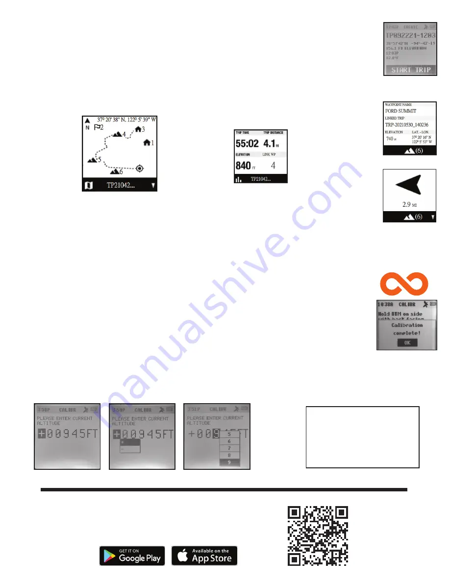
• On the Create screen, select START TRIP (Fig. 14) to create a Trip from one Waypoint to another you have linked and are
in the range of your current location. If “NO WAYPOINT” is shown, there are no saved Waypoints available. You will see
point coordinates, elevation, and temperature on this screen. The Trip with linked Waypoints will appear.
• Pressing the Toggle Down (4) button will show the Digital Compass Display for each linked Waypoint.
• When you have completed your Trip, go to the Settings Menu/Trips and choose STOP TRIP. To access the Trip to restart,
go back to TRIPS and choose VIEW ALL.
• Maximum log time for a single trip is 50 hours. If memory for a single trip is full (over 50 hrs) during trip recording, the
system will log to the last point. Then, the system will pop up a message (Fig. 3) to stop and save a trip. Battery life can
last up to 35 hours under normal GPS operation. Note: The user may need to charge the unit a few times during a long
trip. *During a long journey of 50 hours, the user should create multiple trips. For example, 2 - 25 hour trips or 3 - 16
hour
trips.
COMPASS CALIBRATION (COMP CALIBR)
• It is recommended to calibrate the compass before each use, especially after a long drive or plane flight.
• To ensure directional accuracy, hold the BackTrack Mini out in front of you, with the display facing up in the palm of
your hand and move it in a “Figure 8” pattern a few times to re-calibrate the compass.
• We recommend holding the BackTrack Mini in a horizontal position (not tilted) during use when using on a trip.
• When the calibration is successful, a “Calibration Complete” note will appear.
* Note magnets affect the compass and keep away from the device when calibrating or using the compass
ALTERNATE CALIBRATION (ALT CALIBR)
• If you wish to enter your current altitude manually, you may enter it through the Alternate Calibration option in the
menu. Press Select (2) to scroll through each field and use the Toggle Up or Down buttons (3 & 4) to set the altitude.
When finished, a pop-up noting “Altitude Saved!” will appear.
Fig. 14
Fig. 15
True North
Current GPS
Coordinates
1st Waypoint
Scan the QR code to download the Bushnell
Connect App to your Android or iPhone.
BUSHNELL CONNECT APP
The screen will go off
after five minutes of
inactivity. Press any
button to turn screen on.
Screen Inactivity


