background image

Page 41


accept it, tap 

.


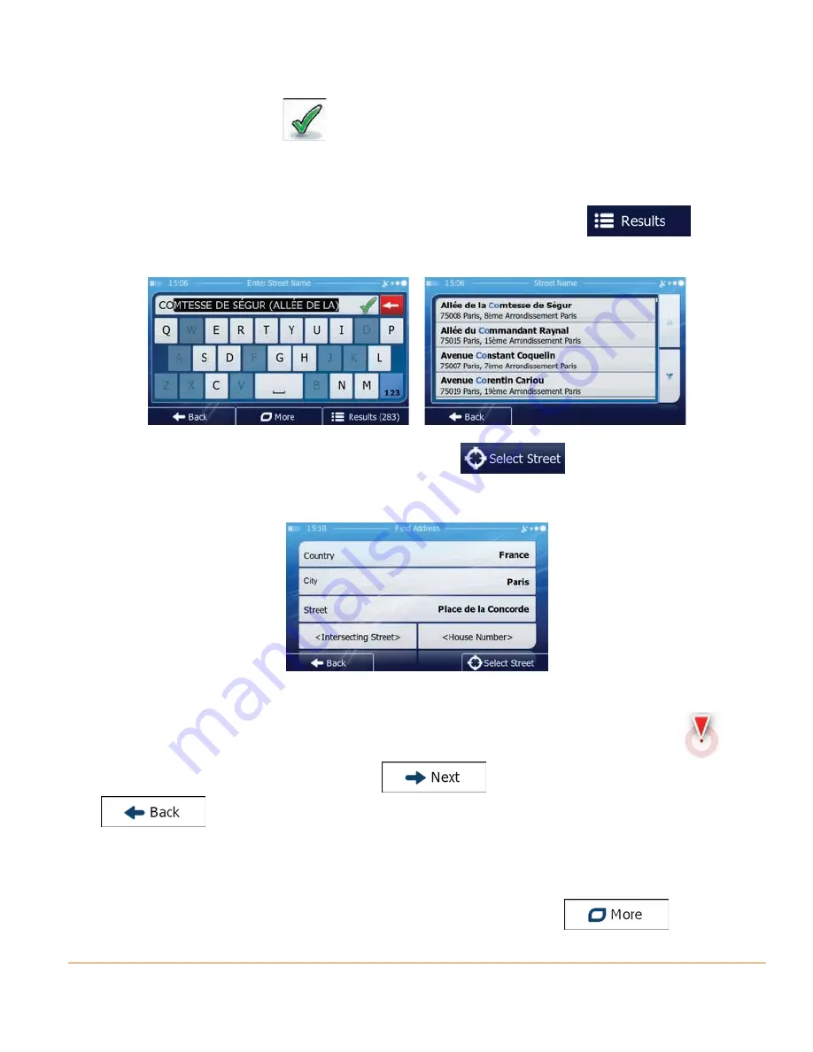
•  If the desired name does not show up, the names that match the  


string appear in a list after entering a couple of characters (to open the 


 list of results before it appears automatically, tap 

). Select  


the street from the list.


5.  Instead of entering the house number, tap 

. The midpoint of the  


street is selected as the destination.


6.  A full screen map appears with the selected point in the middle. If necessary,  


tap the map somewhere else to modify the destination. The Cursor (

)


appears at the new location. Tap 

 to confirm the destination, or tap 


 to select a different destination.

7.  After a short summary of the route parameters, the map appears showing the  
 

entire route. The route is automatically calculated. Tap 


Summary of Contents for iGO50

Page 1: ...iGO50 iGO43 iGO35 In Car Navigation For more exciting new products please visit our website Australia www uniden com au New Zealand www uniden co nz...

Page 2: ...and start using your device right away This document is the detailed description of the navigation software You can easily discover your device while you are using it however we still recommend that y...

Page 3: ...and other controls on the screen 16 2 2 1 Using keyboards 18 2 2 2 Beyond single screen tap 19 2 3 Map screen 20 2 3 1 Navigating on the map 20 2 3 2 Position markers 22 2 3 2 1 Vehimarker and Lock on...

Page 4: ...map location as the destination 63 3 1 4 Selecting the destination from your Favourites 64 3 1 5 Selecting the most likely destination Smart History 66 3 1 6 Selecting the destination from the Histor...

Page 5: ...recalculation 92 5 1 5 Green routing 95 5 1 6 Road Safety Cameras and Other Proximity Alerts Points 96 5 1 7 Speed limit warning 97 5 1 8 Battery and GPS position quality indicators 98 5 2 More menu...

Page 6: ...g or damaged contact your place of purchase immediately iGO50 iGO43 or iGO35 GPS navigation device Press and hold the power button at the TOP of the device to start or resume the navigation programme...

Page 7: ...24VDC outlet Only use the power adapter that comes with your device Any other adapter might damage the device Press and hold the power button at the top of the device to turn it on off Whenever it sen...

Page 8: ...Press the reset button by using the touch pen or a similar tool 5 Touch pen Touch pen 6 Display Screen Display Screen 7 Mini USB Port Charge the GPS device by connecting AC adaptor or car charger 8 Po...

Page 9: ...the road for a few minutes It s a good idea to take valuable items with you when you leave you car that includes GPS devices If you can t take the device with you lock it in the glove compartment or...

Page 10: ...ount 1 Loosen the locking collar on part 2 2 Push the ball joint of Part 1 through the locking collar into part 2 Insert the bracket hook into the notches at the bottom of the device Part 1 Part 2 Rot...

Page 11: ...n the locking collar to secure 4 Gently pull on the mount to make sure it is secure If you have trouble getting the suction cup to stick Clean the spot with an ammonia free cleanser Dry the spot compl...

Page 12: ...r you can enable or disable the log collection in Log Collection settings page 115 It is important that you look at the display only when it is safe to do so If you are the driver of the vehicle we re...

Page 13: ...the first time an initial setup process starts automatically Do as follows 1 Select the written language of the application interface Later you can change it in Regional settings page 114 2 Read the E...

Page 14: ...izard can be restarted later from the Settings menu page 101 8 The software offers you to watch the tutorial that leads you through the basic steps of navigation Tap if you would like to get an instan...

Page 15: ...u From the Navigation menu you can reach all parts of the software You have the following options Tap to select your destination by entering an address or selecting a place of interest a location on t...

Page 16: ...confirm selections or changes if the application needs to restart it needs to perform a major reconfiguration or you are about to lose some of your data or settings Otherwise the software saves your...

Page 17: ...it or till the end Alternatively move between pages with the and buttons and tap the value that you want Slider When a feature can be set to different values in a range the software shows an indicator...

Page 18: ...ard layout for example from an English keyboard to a Greek keyboard Tep the button and select the new keyboard layout from the list Correcting your entry on the keyboard Tap to remove the unneeded cha...

Page 19: ...res can be accessed with combined touch screen tapping Those are the following Action Details Tapping and holding the screen Tap and keep pressing the following buttons to reach extra functions Tap an...

Page 20: ...reen is the most frequently used screen of the software The map is displayed in black and white when there is no GPS position This map shows the current position the Vehimarker a blue arrow by default...

Page 21: ...of the data fields to suppress others and display only the selected one The data fields are different when you are navigating an active route and when you have no specified destination the orange lin...

Page 22: ...vailable for the remaining segments of the route Historical traffic data or traffic patterns are also taken into account whenever such information exists Shows the estimated arrival time at the final...

Page 23: ...cation is selected the Cursor appears at the selected point on the map The Cursor is displayed with a radiating red dot to make it visible at all zoom levels The location of the Cursor can be used as...

Page 24: ...t manoeuvre Both the type of the event turn roundabout exiting motorway etc and its distance from the current position is displayed A smaller icon shows the type of the second next manoeuvre if it is...

Page 25: ...te lane in order to follow the recommended route If lane information is available in the map data the software displays the lanes and their directions using small arrows at the bottom of the map Highl...

Page 26: ...taken all others are darker 2 3 3 4 Junction view If you are approaching a motorway exit or a complex intersection and the needed information exists the map is replaced with a 3D view of the junction...

Page 27: ...l data 3D block representation of full city building data containing actual building size and position on the map 2 3 3 6 Elements of the active route Your software shows the route in the following wa...

Page 28: ...l include them and it will show them in a colour that is different from the route colour 2 3 4 Manipulating the map Tap the map anywhere to browse it during navigation The map stops following the curr...

Page 29: ...ges the vertical view angle of the map in 3D mode Tap the button once to modify the view in large steps or tap and hold the button to modify it continuously and smoothly Rotating left and right Change...

Page 30: ...tination or searching for Places around the Cursor Select destination Tap this button to select the Cursor as a new destination The route is automatically calculated 2 3 5 Quick menu The Quick menu is...

Page 31: ...h to mute all sounds of the device and then to re enable them again More Settings Sound and Warnings Volume Master switch page 102 Tap this button to search for a Place along your route or around your...

Page 32: ...y Route Cancel Route page 77 Tap this button to skip the next waypoint from the route This button replaces the previous one if more destinations are given n a In Settings you can replace the buttons o...

Page 33: ...est in various different ways Find Find Places page 49 This function opens the Map screen and starts simulating the active route My Route More Simulate Navigation page 85 This function opens the GPS I...

Page 34: ...and Longitude coordinates of the current position in WGS84 format Altitude elevation information coming from the GPS receiver often inaccurate House number on the left House number on the right In th...

Page 35: ...or the Quick search The following services can be searched around the current position or the last known position Car repair and roadside assistance services Medical and emergency services Police stat...

Page 36: ...oute You can add as many destinations to your route as you like 3 1 Selecting the destination of a route The software offers you several ways of choosing your destination Enter a full address or a par...

Page 37: ...starting the search with the postal code page 46 3 1 1 1 Entering an address To enter an address as the destination do as follows 1 If you are on the Map screen tap to return to the Navigation menu 2...

Page 38: ...e is always shown in the input field To accept it tap If the desired name does not show up the names that match the string appear in a list after entering a couple of characters to open the list of re...

Page 39: ...ap to finish entering the address If the entered house number cannot be found the midpoint of the street is selected as the destination 7 A full screen map appears with the selected point in the middl...

Page 40: ...n returns automatically Now you can start your journey 3 1 1 2 Entering the midpoint of a street as the destination You can navigate to the midpoint of a street if the house number is not available 1...

Page 41: ...ering the house number tap The midpoint of the street is selected as the destination 6 A full screen map appears with the selected point in the middle If necessary tap the map somewhere else to modify...

Page 42: ...ns 3 If necessary modify the country and settlement as described earlier page 37 4 Enter the street name a Tap b Start entering the street name on the keyboard c Find the street you need The most like...

Page 43: ...e shown on one screen their list appears automatically Select from the list 6 A full screen map appears with the selected point in the middle If necessary tap the map somewhere else to modify the dest...

Page 44: ...Navigation menu 2 In the Navigation menu tap the following buttons 3 If necessary modify the country as described earlier page 37 4 Select the destination city town a Tap b Start entering the name of...

Page 45: ...int in the middle If necessary tap the map somewhere else to modify the destination The Cursor appears at the new location Tap to confirm the destination or tap to select a different destination 7 Aft...

Page 46: ...n to the Navigation menu 2 In the Navigation menu tap the following buttons 3 If necessary modify the country as described earlier page 37 4 Select the destination city town a Tap b Tap to open the nu...

Page 47: ...show up the names that match the string appear in a list after entering a couple of characters to open the list of results before it appears automatically tap Select the street from the list 6 Enter t...

Page 48: ...ameters the map appears showing the entire route The route is automatically calculated Tap to modify route parameters or tap and start your journey 3 1 1 6 Tips on entering addresses quickly When you...

Page 49: ...mple enter PI A to obtain Pine Avenue and skip all Pine Streets and Pickwick Roads You can also search in postal codes As postal codes consist of only a few characters this is usually faster than ente...

Page 50: ...if it exists or around your current location if there is no destination given 1 Start the Quick search function If you are on the Map screen tap and then tap If you are in the Navigation menu tap and...

Page 51: ...e screen 6 optional Tap to see the details of the selected Place Tap to return to the map 7 If necessary tap the map somewhere else to modify the destination The Cursor appears at the new location Tap...

Page 52: ...d around the current position If the current position is not available either no GPS signal they are searched around the last known position If an active route exists parking lots are searched around...

Page 53: ...s not available either no GPS signal they are searched around the last known position 4 Tap any of the quick search buttons to get an instant list of Places 5 optional The Places in the list are order...

Page 54: ...oute parameters or tap and start your journey 3 1 2 3 Searching for a Place of Interest by category You can search for Places of Interest by their categories and subcategories 1 If you are on the Map...

Page 55: ...on Tap to search along the active route and not around a given point This is useful when you search for a later stopover that results in a minimal detour only such as searching for upcoming petrol sta...

Page 56: ...elected main category around the selected location or along the route 8 Sometimes the list of brands in the selected Place subcategory appears Select one brand or tap to list all Places in the selecte...

Page 57: ...point in the middle The name and address of the Place is displayed at the top of the screen 12 optional Tap to see the details of the selected Place Tap to return to the map 13 If necessary tap the m...

Page 58: ...is not available around the last know position The result list will be ordered by the distance from this position Tap to search for a place within a selected city town The result list will be ordered...

Page 59: ...e city town to search in 6 Tap to search in all Places or select one of the main Place categories e g Accommodation to search in 7 Tap to search in the selected Place category or select one of the Pla...

Page 60: ...tional The Places in the list are ordered by their distance from the current or last known position from the selected city town from the destination or by the length of the necessary detour If you nee...

Page 61: ...he destination or tap to select a different destination 15 After a short summary of the route parameters the map appears showing the entire route The route is automatically calculated Tap to modify ro...

Page 62: ...ide assistance services Medical and emergency services Police stations Petrol stations 4 Tap any of the quick search buttons to get an instant list of that type of Places 5 optional The Places in the...

Page 63: ...ination The Cursor appears at the new location Tap to confirm the destination or tap to select a different destination 9 After a short summary of the route parameters the map appears showing the entir...

Page 64: ...ntire route The route is automatically calculated Tap to modify route parameters or tap and start your journey 3 1 4 Selecting the destination from your Favourites You can select a location that you h...

Page 65: ...e of the Favourite destination 4 A full screen map appears with the selected point in the middle If necessary tap the map somewhere else to modify the destination The Cursor appears at the new locatio...

Page 66: ...etter it can guess your desired destination 1 If you are on the Map screen tap to return to the Navigation menu 2 In the Navigation menu tap 3 Tap the or the destination in the History field 4 A full...

Page 67: ...u tap and then tap 2 The list of recent destinations appear Smart History promotes three destinations to the first page based on your previous routes most likely destinations The rest of the destinati...

Page 68: ...and start your journey 3 1 7 Entering the coordinate of the destination You can also select a destination by entering its coordinate The destinations that you have set earlier appear in the History T...

Page 69: ...If necessary tap the map somewhere else to modify the destination The Cursor appears at the new location Tap to confirm the destination or tap to select a different destination 8 After a short summar...

Page 70: ...urn to the Navigation menu 2 In the Navigation menu tap 3 Tap 4 There is only one line in the list of route points the start point of the route normally the current GPS position 5 Tap to select the de...

Page 71: ...e 3 2 Viewing the entire route on the map It is easy to get a map overview of the active route Do as follows 1 If you are on the Map screen tap to return to the Navigation menu 2 In the Navigation men...

Page 72: ...bout your route e g unpaved roads or toll roads to be taken The total time of the route The total length of the route The symbol of the vehicle type used in route calculation The route planning method...

Page 73: ...some of those options 3 4 1 Selecting a new destination when already having a route New Route Waypoint or Final Destination If you already have a recommended route and you select a new destination as...

Page 74: ...destination is now the last waypoint 3 4 2 Setting a new starting position for the route For normal navigation all routes are planned from the current position In order to check future routes simulate...

Page 75: ...menu appears and you can select the start point of the route the same way you select a destination 6 When the new start point is set tap 7 The map returns with a transparent Vehimarker showing that th...

Page 76: ...avigation menu 2 In the Navigation menu tap 3 Tap 4 You have the following options Tap to add a new destination Tap to delete a destination Tap to modify the start point of the route Tap to reorder th...

Page 77: ...points are deleted In the Navigation menu tap and then tap The active route is deleted with all its waypoints 3 4 6 Checking route alternatives when planning the route You can select from different ro...

Page 78: ...rnatives and tap to return to the previous screen The software recalculates the route The orange line now shows the new recommended route 3 4 7 Changing the route planning method route alternatives To...

Page 79: ...el at or near the speed limit on all roads Usually the best selection for fast and normal cars Gives a short route to minimise the distance to travel Usually practical for pedestrians cyclists or slow...

Page 80: ...ample the motorway instead of a series of smaller roads or streets 5 Tap to return to the previous screen The software recalculates the route with the selected route planning method The orange line no...

Page 81: ...igh for a pedestrian You are allowed to switch back instantly to 3 4 9 Changing the road types used in route planning To recalculate the active route with different road type preferences do as follows...

Page 82: ...mporary ferries You might also need to pay a fare on ferries The software excludes unpaved roads by default unpaved roads can be in a bad condition and usually you cannot reach the speed limit on them...

Page 83: ...to enter numbers or symbols 5 Tap to save the location as a new Favourite destination 3 6 Saving a location as an alert point You can save any map location as an alert point for example a speed camer...

Page 84: ...licable the speed limit for this alert point 5 Tap to save the location as a new alert point 3 7 Editing an alert point You can edit a previously saved or uploaded alert point for example a speed came...

Page 85: ...f applicable the speed limit for this alert point 5 Tap to save the changes to the alert point 3 8 Watching the simulation of the route You can run a simulated navigation that demonstrates the active...

Page 86: ...ave the following controls during the simulation the control buttons disappear after a few seconds but you can open them again if you tap the map Jump to the next route event manoeuvre Pause the simul...

Page 87: ...your position and the destination You can use countdown timers to alert you when compulsory breaks must be taken timers can be set for one or two drivers 4 1 Setting up lorry parameters When you use y...

Page 88: ...e is now set To select this truck profile as the vehicle used for navigation tap and select 8 Tap and select the truck profile from the list While this profile is selected the parameters of your vehic...

Page 89: ...continuous and daily driving you can set countdown timers to alert you when you need a break or a sleep This feature can be set for one or two drivers 1 If you are on the Map screen tap to return to...

Page 90: ...never the vehicle stops the current driver receives a message a few minutes later whether this stop means a break When a break is initiated the continuous driving timer stops and it is reset to its de...

Page 91: ...an active route Smart Zoom will zoom in if you drive slowly and zoom out when you drive at high speed 5 1 2 Daytime and night colour themes The software uses different colour themes during the day an...

Page 92: ...the speed limit on all roads Usually the best selection for fast and normal cars Gives a route that has the smallest total distance of all possible routes It can be practical for slow vehicles Gives...

Page 93: ...lculation and an average walking speed is used when calculating the estimated time of arrival Manoeuvre restrictions and directional constraints if they are applied to bicycles in the map data are tak...

Page 94: ...onal constraints are taken into account when planning a route Roads are used only if access for taxis is allowed Private roads resident only roads and walkways are excluded from routes Manoeuvre restr...

Page 95: ...d the green route even if the selected routing method is not Green After the above parameters are set select as route planning method to get a fast but also fuel efficient route Note that travel cost...

Page 96: ...ad safety cameras like speed or red light cameras and other proximity alert points like schools or railroad crossings These alert points are preloaded in the software The application can warn you when...

Page 97: ...d when GPS position is not available or if you are in certain countries where road safety camera warning is prohibited 5 1 7 Speed limit warning Maps may contain information about the speed limits of...

Page 98: ...e top right corner the GPS reception quality icon shows the current accuracy of the position information Icon Description The software has no connection to the GPS receiver GPS navigation is not possi...

Page 99: ...the Map screen turn on or off warnings or restart the Configuration wizard etc See the next chapter for details Visit www naviextras com to get additional content such as new maps or 3D landmarks and...

Page 100: ...rive at some of your destinations or let the application automatically save the trip logs for you those logs are all listed here Tap one of the trips to see the trip statistics speed and altitude prof...

Page 101: ...e and select its new function from the list These settings determine how routes will be calculated Select the type of vehicle you are driving the road types used in route planning and the route planni...

Page 102: ...ogs that may be used for improving the application and the quality and coverage of maps Here you can enable or disable collecting these logs Modify the basic software parameters set during the initial...

Page 103: ...ove which the application initiates the warning The following alert types are available Audio warning you receive a verbal warning when you exceed the speed limit with the given percentage Visual warn...

Page 104: ...d limit while approaching one of these cameras Visual warning the type of the alert point its distance and the related speed limit appear on the Map screen while you are approaching one of these camer...

Page 105: ...n Volume slider Adjusts the volume of the related sound Use the switch to mute the related sound The slider becomes inactive Tap again to re enable 5 3 2 Customise Quick menu The content of the Quick...

Page 106: ...le Weight Tap one of these buttons to change the current or the maximum allowed weight of the lorry Freight The current freight of the lorry may contain hazardous materials Tap this button to select t...

Page 107: ...red for or to be excluded from the route if possible Excluding a road type is a preference It does not necessarily mean total prohibition If your destination can only be accessed using some of the exc...

Page 108: ...them 4WD tracks are dirt roads in very poor condition They can only be driven by 4WD vehicles The software excludes 4WD tracks by default The feature may not be available if your current map does not...

Page 109: ...utes A private road is used only if the destination is there Speed limits are not used in route calculation and an average cycling speed is used when calculating the estimated time of arrival All mano...

Page 110: ...n Gives a quick route if you can travel at or near the speed limit on all roads Usually the best selection for fast and normal cars Gives a short route to minimise the distance to travel Usually pract...

Page 111: ...lps in estimating the CO2 emission Enter the average fuel price for travel cost calculation If necessary tap and select to change the currency If the selected routing method is not Green you can have...

Page 112: ...me used in night mode Replace the default position marker to one of the 3D vehicle models You can select separate icons for different vehicle types selected for route planning Separate icons can be us...

Page 113: ...can be adjusted here The data fields in the corner of the Map screen can be customised Tap this button and select the values you want to see The values can be different when you navigate a route from...

Page 114: ...Screen transitions are also animated Select the style and colours of the application used in daytime mode Select the style and colours of the application used in night mode Adjust the display backlig...

Page 115: ...itor Trip monitor is available from the More menu Button Description Trip monitor can record statistical data of your trips If you need these logs later you can let the application save them automatic...

Page 116: ...vigation software is collected for later development purposes Understanding how different people use the application can help us improve the user interface and the program workflow Anonymous track log...

Page 117: ...f the settlement but an arbitrary point the map creators have chosen In towns and villages it is usually the most important intersection in larger cities it is one of the important intersections Colou...

Page 118: ...alert points for speed red light or bus lane cameras Different data sources are available You can configure the software to warn you when you approach one of these cameras Detecting the location of Ro...

Page 119: ...are into a vehicle pressing of the Accept button displayed by the software during installation or use hereinafter referred to as Use shall mean that the User has accepted the terms and conditions of t...

Page 120: ...5 3 The owner s of the copyrights of the Database forming part of the Software Product is are the natural person s or corporate entity ies listed in the Appendix to this Agreement or in the About men...

Page 121: ...hereof 7 1 2 to lease rent or lend it or to transfer it to a third person for any reason 7 1 3 to translate the Software Product including translation compilation to other programming languages 7 1 4...

Page 122: ...tware Product obtained by the User should be completely error free 8 2 The Licensor does not warrant that the Software Product is suitable for any purpose defined either by the Licensor or the User an...

Page 123: ...the expense of the person in breach and may demand the destruction of instruments and materials used to commit the breach as well as of the products created by the breach 9 1 6 claim for damages 9 2 T...

Page 124: ...tual partner may offer various products and services to the User through www naviextras com The User may only use these services when the User has read and understood the relevant end user licence agr...

Page 125: ...as the Product to be free from defects in materials and craftsmanship with only the limitations or exclusions set out below WARRANTY DURATION This warranty to the original retail owner only shall ter...

Page 126: ...EXPRESS WARRANTY is in addition to and does not in any way affect your rights under the TRADE PRACTICES ACT 1974 Cth Australia or the CONSUMER GUARANTEES ACT New Zealand PROCEDURE FOR OBTAINING PERFOR...

Page 127: ...Page 127 Notes...

Page 128: ...Thank you for buying a Uniden product 2010 Uniden Australia Pty Limited Uniden New Zealand Ltd Printed in PRC...

Reviews: