


STORMBEE Software User Manual
–
Think 3D BVBA
Version N°1.1, last modified 30/09/2018
11
3
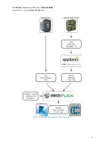
Applanix POSPac UAV
3.1
Installation POSPac UAV
POSPac UAV is differential GNSS-aided inertial post-processing software for georeferencing
STORMBEE
’s flight trajectory. It corrects
STORMBEE
’s flight trajectory, measured on
-board by APX20
equipped with IMU and GPS antenna. It uses GPS satellite ephemeris (trajectory) and GPS base station
data to achieve robust, centimetre level position and orientation information worldwide.
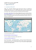
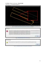
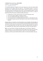
You can find a map showing all base stations worldwide that are used by POSPac UAV here:
https://applanixsmartbase.com/
. You need to (freely) register with Trimble to see the map of all base
stations worldwide (Figure 3.1). In case no base stations are near your mission location, POSPac UAV
allows you to use Applanix SmartBase option (requires additional Trimble subscription, not free) or use
data from your own GPS station.
Figure 3.1 Applanix base stations worldwide
You can download POSPac UAV here:
https://www.applanix.com/contact.htm#support
If you are not registered for download yet, please register here:
https://www.applanix.com/register.htm
Go to “Airborne Support”
→
“Download and Updates”
→
“PosPac UAV”.
Please download the latest
version. Current version at time of writing these instructions: PosPac UAV 8.3. A zip-file will start
downloading. Simply unpack it and install with default settings.
You may need to temporarily disable
you virus scanner during installation.