background image


User manual 


18 

3-2 High Way 

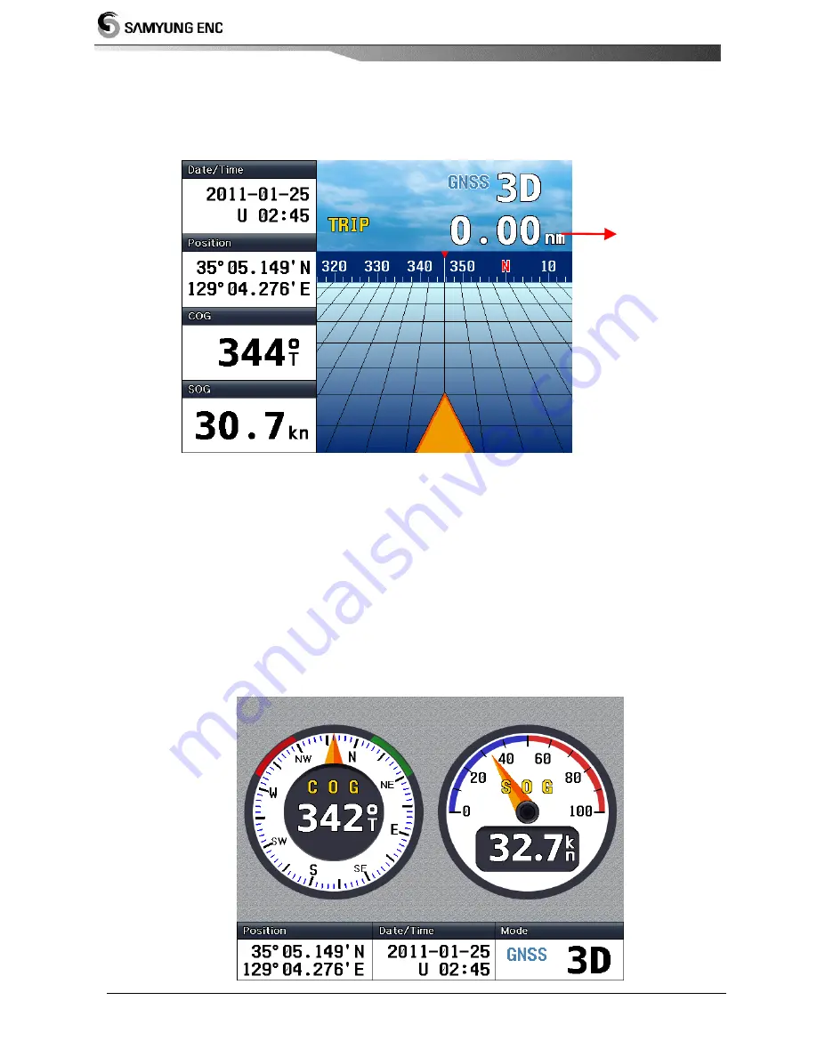
Press F2 to display High Way 

High way shows in 3D when vessel is sailing to the destination. 


① 

TRIP


It shows the distance travelled after the equipment has been turned on. 

 
3-3 DATA 

  DATA displays when you press F3 

It shows COG and SOG of vessel in gauge 


① 

Summary of Contents for SGN-500

Page 1: ...User Manual 1...

Page 2: ...User manual 2...

Page 3: ...ure to extreme heat or power has been connected with reversed anode may cause a severe damage to the chart plotter Damage caused by these reasons may not be covered by our warranty You shall not disas...

Page 4: ...User manual 4...

Page 5: ...ly 11 2 4 Connecting the external data 11 2 4 1 RS 422 11 2 4 2 RTCM 11 2 5 Installing Antenna 12 2 6 Installing DGNSS 12 2 7 Connection to equipment cable 14 3 Function 3 1 Position Description of di...

Page 6: ...company This technology is permitted to the user under the temporary agreement and permits therefore please use the product for its agreed use Please be aware that it is against the law to copy it il...

Page 7: ...IC LCD which allows wide viewing angle it is easy to read and operate wherever the equipment is installed 5 No initial setup is required and fast initial satellite tracking 6 You can adjust the BACK L...

Page 8: ...mA Minimum brightness of LCD 560 mA Maximum brightness of LCD Operation temperature 15 55 C GNSS NAVIGATION Receive Frequency L1 1590 MHz 20MHz Number of channels 24 GNSS System available Card SD card...

Page 9: ...75 SQMM x 2C 3Meter Bracket mounting bolt SGN 500 BP GLONASS antenna GLONASS antenna holder GLONASS 50 User manual in English SGN 500 ME 25P data connector HDBB25S 1 6 Option Component model contents...

Page 10: ...pecial techniques to install however you must follow the basic standard of installation as listed below to maintain the function of the equipment 2 2 Selecting where to install Select where to install...

Page 11: ...unctions for each pin numbers are as below Number Pin name function 7 data RX 422 For connecting to the external equipment DATA RX RS 422 input 18 data TX 422 For connecting to the external equipment...

Page 12: ...nd no obstacles should be around at its level of surface If this cannot be followed install it where you can see the most of the sky 3 You must install it as far away from the wireless transmitter s a...

Page 13: ...en installing The DGNSS antenna of main unit s connector is as below Number Pin name function 8 POWER positive Power input 12V DC 1 13 14 25 POWER Negative There is no need to connect all the pins Two...

Page 14: ...o install it at the most convenient place 1 When wiring the power if it is DC wire you must use the CABLE supplied by us or CABLE with enough capacity of current 2 You must lock the navigation equipme...

Page 15: ...User Manual 15 Option Beacon Receiver External Device Option GNSS ANTENNA STANDARD Option Power supply SP5AD Input AC110 220V DC24V Output DC24V Buffer...

Page 16: ...WAAS DGLONASS GLONASS SIM 3D on the top left changes to DR when satellite has not been selected and when satellite has been selected and positioning is 2 dimensional it will display 2D and 3D when it...

Page 17: ...splayed for Local time COG Course of vessel This displays the bearing of the vessel when moving Direction of vessel which is a relative bearing to site SOG Speed of vessel Displays the current speed o...

Page 18: ...o display High Way High way shows in 3D when vessel is sailing to the destination TRIP It shows the distance travelled after the equipment has been turned on 3 3 DATA DATA displays when you press F3 I...

Page 19: ...s F4 Equipment needs some time to receive GNSS signal when first turned on Satellite information displays GNSS gain and GNSS location as below Location of GNSS satellite The strength of GNSS signal in...

Page 20: ...n this key is pressed MENU displays 4 1 Setup Output Data By using NMEA0183 you may select the data to transmit when you are communicating with other equipment Select which data you wish to transmit a...

Page 21: ...ion Information 1 2 3 4 5 6 7 8 9 RMC hhmmss ss A llll ll a yyyyy yy a x x x x xxxxxx x x a a hh 1 UTC of position fix 2 Status V Navigation receiver warning A Data valid 3 Latitude N S 4 Longitude E...

Page 22: ...x xxxx hh 1 UTC of position 2 Latitude N S 3 Longitude E W 4 GPS Quality indicator 5 Number of satellites in use 00 12 may be different from the number in view 6 Horizontal Dilution of precision 7 Al...

Page 23: ...a x x ccc hh 1 Local datum code WGS84 W84 WGS72 W72 SGS85 S85 PE90 P90 User defined 999 IHO datum code 2 Local datum subdivision code 3 Lat offset minutes N S 4 Lon offset minutes E W 5 Altitude offse...

Page 24: ...User manual 24 4 2 SETUP I O PORT Set the speed same with the equipment you are communicating with Set the speed then press SAVE 4 3 PORT MONITORING The details of transmission gets displayed...

Page 25: ...UME F3 in order to display the data received 4 4 CONFIGURATION General setting and brightness adjustment is possible Select SAVE after setup Select the language you wish to use English Russian Select...

Page 26: ...User manual 26...

Page 27: ...User Manual 27 5 1 External diagram 5 Diagram...

Page 28: ...User manual 28 5 2 GLONASS antenna diagram...

Page 29: ...User Manual 29...

Page 30: ...ill repair them for you The repairing of the product will be charged even if the product is within the warranty in the following cases 1 When fuse or spare parts of consumables have ended their lives...

Page 31: ...User Manual 31...

Page 32: ...User manual 32...

Page 33: ...User Manual 33...

Reviews: