


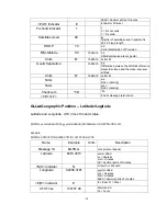
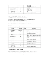


20
dddd = decimal parts of minutes
<E|W> Indicator
E
E=east or W=west
Fix Valid Indicator
1
v
0 = Fix not valid
1 = Fix valid
Satellites Used
09
ss
Number of satellites used in position fix,
00-12. Fixed length
HDOP 1.0
d.d
Horizontal Dilution of Precision
MSL Altitude
9.0
meters
h.h
Altitude(mean-sea-level, geoid)
Units M
meters
Letter M
Geoid Separation
meters
g.g
Difference between the WGS-84 reference
ellipsoid surface and the mean-sea-level
altitude.
Units M
meters
Letter M
NULL
a.a
NULL (missing)
NULL
xxxx
NULL (missing)
Checksum *5D
*hh
<CR><LF>
End of message termination
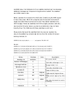
GLL
-
Geographic Position – Latitude/Logitude
Latitude and Longitude, UTC time of fix and status.
$GPGLL,xxmm.dddd,<N|S>,yyymm.dddd,<E|W>,hhmmss.dd,S,M*hh<CR><LF>
Example:
$GPGLL,6016.3073,N,02458.3791,E,134157.48,A,A*26
Name Example
Units Description
Message ID
$GPGLL
GLL protocol header
Latitude 6016.3073
xxmm.dddd
xx = degrees
mm = minutes
dd = decimal parts of minutes
<N|S> Indicator
N
N=north or S=south
Longitude 02458.3791
yyymm.dddd
yyy = degrees
mm = minutes
dddd = decimal parts of minutes
<E|W> Indicator
E
E = East, W = West
UTC Time
134157.48
hhmmss.dd
hh = hours