


H
NovAtel Format Logs
GPS/GLONASS Receiver User Manual Rev 1
103
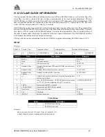
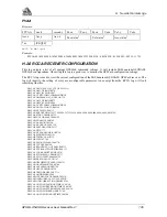
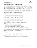
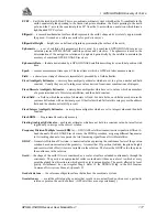
Figure H.1 Navigation Parameters
Reference
Description
Reference
Description
A
FROM, lat-lon
F
Current GPS position
B
TO, lat-lon
FD
Current distance and bearing from F to D
AB
Great circle line drawn between
E
Xtrack perpendicular reference point
FROM A lat-lon and TO B lat-lon
EF
Xtrack error from E to F
AC
Track offset from A to C
(perpendicular to CD)
BD
Track offset from B to D
FG
Along track from F to G
CD
Offset track to steer (parallel to AB)
(perpendicular to BD)
H
Variation (local MAGVAR correction = -20°)
I
Magnetic bearing
J
True bearing
AB - True bearing = 70°
AB - Magnetic bearing = True + (MAGVAR correction) = 70° + (-20°) = 50°
H.2.3 POSA/B COMPUTED POSITION
This log will contain the last valid best-available-position and time-calculated referenced to the antenna phase
center. The position is in geographic coordinates in degrees based on your specified datum (default is WGS84).
The height is referenced to mean sea level. The receiver time is in GPS weeks and seconds into the week. The
estimated standard deviations of the solution and current filter status are also included.
POSA
Structure:
Note:
1
See Table H.8 (Page 111)
Example:
$POSA,991,428326.00,51.11638173,-114.03824540,
1092.104,-16.271,61,14.412,8.799,25.020,0*1E
$POSA
week
seconds
lat
lon
hgt
undulation
datum ID
lat std
lon std
hgt std
sol status
1
*xx
[CR][LF]