background image

99 

To change LineOut Volume

: from the Sounds menu, use the 


keys to increase or decrease the volume. 

To set Key Sounds:

 from the Sounds menu, highlight 

K

EY 

P

RESS 

S

OUNDS

 and press 

ENT


to turn them on (check) or turn them off (un-

check).  

To set Alarm Sounds: 

from the Sounds menu, highlight 

A

LARM 

S

OUNDS


and press 

ENT


to turn them on (check) or turn them off (uncheck).  

To set Alarm Style

, from the Sounds menu, highlight 

A

LARM 

S

TYLE

|

ENT

Press 

 or 

 to change the style and press 

ENT

. After the option is set, 

press 

EXIT

|

EXIT

 to return to the main page display. 

Repeat and Shuffle:

 For information on Repeat and Shuffle com-

mands, see Section 7: Music Mode. 

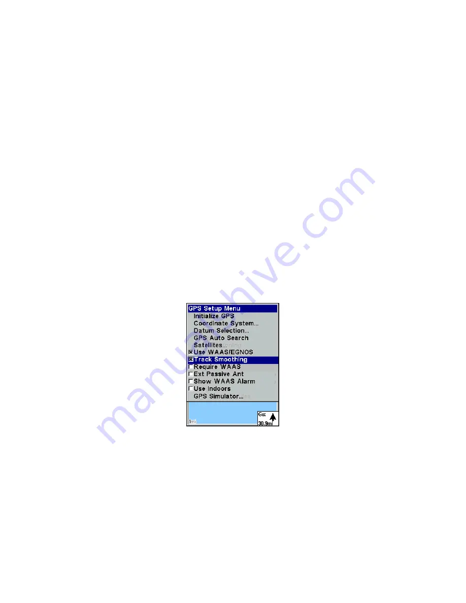
Track Smoothing 

This is a factory setting that 

should always be turned on

. When stopped 

or traveling at slow speeds, Track Smoothing prevents trails from wan-

dering. The steering arrow, compass rose and map also benefit from 

Track Smoothing. 

To turn on Track Smoothing

, press 

MENU

|

MENU

, select 

GPS


S

ETUP


and press 

ENT

. Scroll down to 

T

RACK 

S

MOOTHING

 and press 

ENT

 to turn it 

on (check).  


Track Smoothing option turned on. 

Trail Options 

There are several options you can use with trails. Some affect all trails, 

others may be applied to specific trails. A few of the options include, 

displaying, hiding, creating, editing and deleting trails. These options 

are only available in Advanced Mode, but also will affect the appear-

ance of trails in Easy Mode. 

www.Busse-Yachtshop.de      email: [email protected]

Summary of Contents for Finder Expedition C

Page 1: ...Pub 988 0160 011 www lowrance com Mapping GPS MP3 Player Operation Instructions www Busse Yachtshop de email info busse yachtshop de...

Page 2: ...registered trademark of Rayovac Corporation Energizer and e2 are registered trademarks of Energizer Holdings Inc Points of Interest Data in this unit are by infoUSA copyright 2001 2005 All Rights Rese...

Page 3: ...16 R A M Bracket Mounting Systems 17 Other Accessories 18 Section 3 Easy Mode Operation 19 Keypad 19 Power lights on and off 20 Main Menu 20 Pages 21 Satellite Status Page 21 Navigation Page 22 Map Pa...

Page 4: ...48 Find Your Current Position 49 Icons 49 Create Icon on Map 49 Create Icon at Current Position 50 Delete an Icon 50 Load GPS Data Files from an MMC 50 Navigate 51 Navigate Back Home 51 Navigate Back...

Page 5: ...ep Mode 65 Waypoints 66 Create Waypoint on Map 66 Create Waypoint at Current Position 66 Create a Man Overboard Waypoint 66 Create a Waypoint by Average Position 66 Create a Waypoint by Projecting a P...

Page 6: ...tes 87 Port Information 88 Tidal Current Information 89 Tide Information 91 Navionics Charts 92 Pop up Help 93 Reset Options 94 Screen Contrast and Brightness 94 Set Language 96 Set Local Time 96 Soft...

Page 7: ...ind Waypoints Advanced Mode only 116 Section 7 Music Mode 119 The Music Mode Display 119 Play Control Buttons 120 Launch Music Browser 120 Music Mode Practice Run 122 Play Lists 123 Getting Music onto...

Page 8: ...lso visually check to make sure a clear safe path to the waypoint is always available WARNING When a GPS unit is used in a vehicle the vehicle operator is solely re sponsible for operating the vehicle...

Page 9: ...traveling and less time reading the manual So we designed our book so that you don t have to read the whole thing from front to back for the information you want At the start or end of each segment we...

Page 10: ...up Options This section covers both Easy Mode and Advanced Mode options In Section 6 we go into more detail on one of the iFINDER s most re markable capabilities Searching We ll introduce a couple of...

Page 11: ...ta to personal computer without a slow serial connection MMC slots One inside battery compartment Accepts non proprietary MMC or SD memory cards Background map Built in custom detailed Lowrance map Co...

Page 12: ...limited by the number of MMC cards you have How the iFINDER ExpeditionC Works You ll navigate faster and easier if you understand how the iFINDER scans the sky to tell you where you are on the earth a...

Page 13: ...ter Just as computers have a floppy disk drive for storing and ex changing files the iFINDER has a slot for an MMC MultiMedia Card or SD Secure Digital Card flash memory card These solid state mem ory...

Page 14: ...Department of Defense It was designed as a 24 hour a day 365 days a year all weather global navigation system for the armed forces of the U S and its allies Civilian use was also avail able at first b...

Page 15: ...R to determine direction of travel you must be moving and the faster the better This is not to say that it won t work at walking or trolling speeds it will There will be more wandering of the data sho...

Page 16: ...ination It s up to you to safely navigate around obstacles no matter how you re using this product How to use this manual typographical conventions Many instructions are listed as numbered steps The k...

Page 17: ...manner for quick and easy reading For example instructions for backtracking a trail in Easy Mode would look like this 1 Press MENU to NAVIGATE TRAIL ENT 2 Now let the iFINDER guide you Translated into...

Page 18: ...10 Notes www Busse Yachtshop de email info busse yachtshop de...

Page 19: ...as those made by RAYOVAC or rechargeable AA nickel metal hydride NiMH batteries We do not recommend nickel cadmium NiCd rechargeable batteries because we tend to get poor battery life from them Recha...

Page 20: ...t point the positive pole of the bottom battery to the right NOTE Inside the battery compartment is a rotating MMC card lock The grip on this lock must be turned parallel with the direction of the bat...

Page 21: ...your warranty The iFINDER can use two other optional external cables to supply a NMEA serial data connection or a combination of power and data These cables are discussed in the following segment on N...

Page 22: ...mation NOTE Throughout this manual we will use the term MMC but just re member your unit can use an MMC or SD card to store data Both of these solid state flash memory devices are about the size of a...

Page 23: ...down on the center of the label and slide the card to the right Add an MMC Card 5 Turn the plastic rotating card lock until it holds the card firmly in place with the grip parallel to the direction of...

Page 24: ...Elite provides superb coverage of more than 2 000 of America s premier inland fishing lakes The mapping detail which in cludes depth contour lines and excellent shoreline detail is preloaded onto one...

Page 25: ...switch between it and the internal antenna See the topic Exter nal Passive Antenna in Sec 5 Attach the iFINDER antenna to windshield bracket with two screws You may achieve good results by placing th...

Page 26: ...rmation is on the inside back cover of this man ual For a complete look at the many mounting options visit the R A M web site at www ram mount com Other Accessories Other iFINDER accessories include M...

Page 27: ...e on page 28 Keypad iFINDER ExpeditionC keypad 1 PWR LIGHT The PWR key turns the unit on and off and activates the backlight 2 PAGES Pressing this key switches the unit between four page screens in Ea...

Page 28: ...ess EXIT to message or alarm displays Turn off the unit by pressing and holding the PWR key for 3 seconds Main Menu Easy Mode has a single Main Menu which contains function and setup option commands T...

Page 29: ...duct name and software version of the unit s operating system software as well as copyright notices Pages Easy Mode has a three page display They are Satellite Status Page Navigation Page and Map Page...

Page 30: ...le satellite The taller the bar on the graph the better the unit is receiving signals from the satellite The Estimated Position Error EPE shown above the bar graphs is the expected error from a benchm...

Page 31: ...age as a vertical dotted line Lines on either side of the present position show the current cross track error range The default for the cross track error range is 0 20 mile For example if the present...

Page 32: ...ected item whether it is a waypoint you made a map feature or an item from the POI database Using the map is as simple as pressing the PAGES key A screen similar to those in the following images will...

Page 33: ...massive amounts of accurate map detail Map Pages with high detail map of an urban area loaded on the MMC Arterial streets appear at the 4 mile zoom range left with a few Point icons visible Numerous...

Page 34: ...line completely and accurately finer detail Many smaller islands would not be included in the background map but are in MapCreate When the map is zoomed out far enough most POIs appear as square dots...

Page 35: ...POIs and their icons will pop up when the unit finds them The following page contains a 12 step quick reference for Easy Mode operation If you don t want to carry the manual with you as you prac tice...

Page 36: ...of the earth You can move around the map by zooming out zooming in or scrolling Zoom in closer to see greater detail press ZIN zoom in key Zoom out to see more area less detail press ZOUT zoom out key...

Page 37: ...ye view The current zoom range shows in the lower left corner of the screen 1 Press the ZIN key zoom in to move in closer and see greater detail in a smaller geographic area 2 Press the ZOUT key zoom...

Page 38: ...the Find Menu will pop up with SELECTED ITEM listed at the top of the menu Press ENT to see the Way point Information screen for the selected item Searching Now that you have seen how the iFINDER can...

Page 39: ...ou can use the iFINDER as a business phone directory If you wanted to navigate there you could press Enter since the GO TO command is highlighted But we just want to see it on the map so press to FIND...

Page 40: ...Set Home Waypoint A waypoint is an electronic address based on the latitude and longi tude of a position on the earth Easy Mode allows you to save two way points Home and Man Overboard To save a Home...

Page 41: ...as the man overboard position Caution Saving a new Man Overboard waypoint will overwrite and erase the previous Man Overboard waypoint Navigate Back to MOB Waypoint Find your way back to the position...

Page 42: ...example be low Many map items such as waypoints Points of Interest towns etc can be selected and appear highlighted with a pop up box Other items like a river or a street intersection will not appear...

Page 43: ...Use to highlight a category and press ENTER The FIND BY MENU will appear with two options NAME and NEAREST Select NEAREST and press ENT A list of locations will appear with the one near est you highl...

Page 44: ...of the automatic trail creation feature in Easy Mode Displaying a Saved Trail The trail is automatically displayed in Easy Mode by default Trail dis play can be turned off and on only in Advanced Mode...

Page 45: ...e next waypoint on the trail As you travel the arrival alarm will go off when you get close to a way point and the steer arrow on the map and bearing arrow on the com pass rose will swing around and p...

Page 46: ...ding a new one by using the Clear Trail command WARNING Clearing a trail will erase the trail from the iFINDER s memory You will not be able to back track the trail if it is erased If you need to pres...

Page 47: ...asks if you want to save data to the MMC or load data from the MMC into the iFINDER s memory 2 If no MMC is present a message will appear letting you know there is no card in the iFINDER You must ins...

Page 48: ...o the main page display press EXIT EXIT These figures left to right show the menu sequence for loading a GPS Data File from an MMC into the iFINDER s memory Switch to Advanced Mode To leave Easy Mode...

Page 49: ...are used to navigate through the menus make menu selections move the chart cursor and enter data 5 ENT The enter key allows you to save data accept values or exe cute menu commands 6 EXIT The Exit key...

Page 50: ...But if you want to learn about the various options see Sec 5 System Setup and GPS Setup Op tions 1 To get to the main menu from any page press MENU MENU To clear the menu screen and return to the page...

Page 51: ...ough the four screens in an endless loop Each Page has its own menu You can access a page menu by pressing the MENU key while the page is displayed Pressing the Menu key twice will always take you to...

Page 52: ...hing GPS Auto Search and Use Indoors Digital Data Page This page provides detailed information on the position of the iFINDER s cursor From this page you can determine your latitude longitude altitude...

Page 53: ...ng to a waypoint Your position is shown by an arrow in the center of the screen and your trail history the path you took is depicted by the line extending from the arrow The large arrow pointing down...

Page 54: ...he music player s commands are available at the touch of a single button The most important tools are the play control buttons ENTER Play and Pause EXIT Stop Previous Song and Next Song If you hold do...

Page 55: ...The Zoom In and Zoom Out keys zoom the map to enlarge or reduce its coverage area and the amount of mapping detail shown There are 40 available map zoom ranges from 0 02 miles to 4 000 miles NOTE Refe...

Page 56: ...ward southward eastward or westward using the arrow keys which will launch the cursor cross hairs To clear the cursor press EXIT and the map will switch back to the current or last known position Find...

Page 57: ...nd back on again If the cursor is activated any information the unit gives you will be based on the cursor position not your own If you want to find where you are just press EXIT until the cursor disa...

Page 58: ...ons represented by a particular symbol or use the cursor to delete an icon selected from the map 1 Press MENU to DELETE MY ICONS ENT 2 Press to DELETE ALL ICONS DELETE BY SYMBOL or DELETE FROM MAP and...

Page 59: ...har acter and repeat until the name is correct Then press ENT to SAVE ENT The unit will display a completion message when the data transfer is finished To return to the main page display press EXIT re...

Page 60: ...ap you can easily use the Navigate to Cursor command above Use the cursor to select the POI The other method involves searching for POIs with the Find command see Sec 6 Searching for detailed instruct...

Page 61: ...le the iFINDER creates a route from the trail When the progress message disappears the unit displays a trail infor mation screen with NAVIGATE ROUTE highlighted in the top command box Tip Back Track a...

Page 62: ...reverse order You can even begin navigating in the middle of a route Create and Save a Route In the iFINDER routes can be created edited and navigated only in Advanced Mode You have the option of cre...

Page 63: ...ute waypoint 1 at 11th St 145th Ave Fig 2 Zoom in move cursor north to set point 2 at 145th Admiral Fig 3 With point 2 set move cursor east to mark interstate on ramp with waypoint 3 In figures 2 and...

Page 64: ...TE ROUTE ENT to YES ENT Save GPS Data Files to an MMC 1 Press MENU MENU to SYSTEM SETUP ENT to TRANSFER MY DATA ENT 2 You must insert an MMC card into the iFINDER to be able to save a data file 3 To s...

Page 65: ...s is how you can use the iFINDER as a business phone directory If you wanted to navigate there you could press Enter since the GO TO command is highlighted We just want to see it on the map so press t...

Page 66: ...y true limit on the number of trails you can record is the number of MMCs you can carry in your pockets For various trail options see the Trail Options entry in Sec 5 Create and Save a Trail The iFIND...

Page 67: ...Select a trail from the Saved Trail list and press ENT Select PATTERN and press ENT By default the pattern will consist of a series of asterisks To add or erase an asterisk from a trail pattern use th...

Page 68: ...NT to acti vate the File Name selection box Press or to change the first char acter then press to the next character and repeat until the name is correct Press ENT to SAVE DATA ENT To accept the defau...

Page 69: ...trip calculation use the Trip Active command to disable calculation Reset Trip The Reset Trip command clears calculated values and starts recording new trip information Threshold You can use the Thre...

Page 70: ...eter in your GPS unit can sharpen your weather skills by tracking changes in barometric pressure at your location It will tell you if local atmospheric pressure is steady rising or falling and how fas...

Page 71: ...page with barometric Pressure History box at the top and Weather Symbol box at lower left When the iFINDER is first turned on and determines its position and the local time it takes a barometric press...

Page 72: ...monitoring the trend steady rising or falling the iFINDER can predict how the weather will likely behave Weather Symbol box showing Rain symbol The following weather symbols are based only on the las...

Page 73: ...has more information to work with it can provide better weather predictions In order to help with this we have designed the iFINDER with a Sleep Mode that allows it to conserve battery life while occ...

Page 74: ...waypoint symbol and number appear on the map Create a Man Overboard Waypoint This unit has a man overboard feature that shows navigation data to the location where the feature was activated To activa...

Page 75: ...n will appear as the reference position on the map 6 Press to DISTANCE ENT Press or to change the first character then press to the next character and repeat until the distance is cor rect Press ENT 7...

Page 76: ...select LATITUDE and press ENT Use to change the first character then press to the next character and repeat until the lati tude is correct Press EXIT 2 Longitude press to LONGITUDE ENT Use to change...

Page 77: ...e on After saving the waypoint you can record an audio note giving specific information related to the waypoint that would have otherwise been undocumented To record an audio note 1 Press FIND MY WAYP...

Page 78: ...70 Notes www Busse Yachtshop de email info busse yachtshop de...

Page 79: ...le or more to the right or left of the line to the waypoint The anchor alarm is triggered when you drift outside of a preset radius If you are anchored and your boat moves more than 0 1 mile an alarm...

Page 80: ...UTC time and date Elevation altitude is also used in the equation but it is rarely required to determine a position It needs this data so it can calculate which satellites should be in view It then s...

Page 81: ...press ENT to access information about the MMC card From the MMC Card information screen you can format the card which erase the data or Create an ID File Main Menu left MMC File Browser center with M...

Page 82: ...s showing the prefixes of the available NMEA sen tences A check mark next to a prefix means the prefix is in use Use to select a prefix then press ENT to turn the prefix on or off Communication Port m...

Page 83: ...map with WAAS EGNOS on then turn it off and check again Use the setting most accurate in your area To Turn on or off WAAS EGNOS 1 Press MENU MENU to GPS SETUP ENT 2 Press to USE WAAS EGNOS ENT which...

Page 84: ...reference system MGRS uses two grid lettering schemes referred to as standard and alternate MGRS on this unit Your position and datum in use determines which one to use If you use standard and your po...

Page 85: ...tude NOTE In order for this system to work the latitude longitude lines must be parallel with the edge of the map USGS maps are parallel oth ers may not be This works better with smaller scale maps Th...

Page 86: ...he pages NOTE In Advanced Mode you can remove pages you do not want to have in the Pages rotation Press MENU MENU then scroll down to SYS TEM SETUP and press ENT Press to CHOOSE VIEWABLE PAGES and pre...

Page 87: ...desired data option and press ENT which will turn it on check or turn it off uncheck Check or un check other data options to change the data displayed in other boxes If you get an Overlay Limit Excee...

Page 88: ...ROWS or by setting the track and speed in the boxes provided on the simulator screen To get to the GPS Simulator 1 Press MENU MENU to GPS SETUP ENT 2 Press to GPS SIMULATOR ENT GPS Setup Menu left The...

Page 89: ...or route When you arrive at your destination cancel navigation Map Auto Zoom This receiver has an auto zoom feature that eliminates much of the button pushing common with other brands of GPS receiver...

Page 90: ...ected on Scout menu center Add from Map high lighted on the Edit Scout points menu right 4 As you walk the perimeter of the area you are scouting you will re cord a series of scouting waypoints that w...

Page 91: ...cs maps also may be accessed on the Map Data menu For detailed instructions see the Navionics Charts entry in this section Map Menu left with Map Data Menu right To Show Map Data Press MENU to MAP DAT...

Page 92: ...option highlighted press ENT to turn it on check or turn it off uncheck To set Lat Lon Grid Lines From the Map Data menu press to LAT LON GRID LINES With the option highlighted press ENT to turn it on...

Page 93: ...d turned off only in Advanced Mode Map Menu left with Map Categories Drawn Menu right To get to Map Categories 1 From the Map page press MENU to MAP CATEGORIES DRAWN ENT 2 Press or to select a categor...

Page 94: ...map as you turn That way what you see on the left side of the screen will always be to your left and what you see on the right side of the screen will always be on your right Another option is course...

Page 95: ...custom map on a MMC Nautical Chart Notes NauticPath charts contain notes or chart information represented by cir cle i Chart Note icons on the map display An example is shown in the following figure...

Page 96: ...y These icons will appear when you are zoomed in to a 4 nautical mile range An example is displayed in the following figures To view Port Services information 1 Use the arrow keys to move the cursor o...

Page 97: ...right When you zoom in to a sufficiently small zoom range 0 8 nautical mile the icon becomes an animated arrow showing tidal current veloc ity and direction for the selected tidal station at the prese...

Page 98: ...dynamically based upon the maximum velocity of the current for that day Slack water the period of little or no current is represented by the Slack Water Line SWL The flood appears above the SWL and t...

Page 99: ...es you can select the boxed T icon and it becomes an animated gauge with a pop up name box The name box disappears after a few seconds To view tide information 1 Use the arrow keys to move the cursor...

Page 100: ...d year selection boxes To select another date 1 Use and to highlight month day or year then press ENT 2 Use and to select the desired month day or year then press ENT To clear the information screen p...

Page 101: ...ning your Navionics chart Formatting the MMC will permanently erase the chart from the card Pop up Help Help is available for most all menu items on this unit Selecting a menu item and leaving it high...

Page 102: ...s icons or plot trails Advanced Mode s Reset Options command left and the Reset Options Menu right Screen Contrast and Brightness Screen adjustments work the same in both Easy and Advanced Mode but yo...

Page 103: ...ess selected Display mode menu To adjust the screen s display mode 1 From the screen menu press to DISPLAY MODE ENT then press or to select mode EXIT 2 To return to the main page display press EXIT EX...

Page 104: ...ct a different language and press ENT All menus now appear in the language you selected Press EXIT EXIT to return to the main page display Set Local Time The method for setting local time works the sa...

Page 105: ...t and press ENT Use the to select the desired format and press ENT Adjusting local time left and Adjusting the month right The last field in this menu is CONFIG DST It allows your unit to auto matical...

Page 106: ...SYSTEM SETUP ENT to SOFTWARE INFO ENT 2 Read the information displayed on the screen 3 To return to the main page display press EXIT repeatedly Sounds and Alarm Sound Styles Key strokes and alarm soun...

Page 107: ...Section 7 Music Mode Track Smoothing This is a factory setting that should always be turned on When stopped or traveling at slow speeds Track Smoothing prevents trails from wan dering The steering arr...

Page 108: ...teria set to Auto left Update Criteria set to Time center Update Criteria set to Distance right When Time or Distance are selected a dialog box will appear auto matically WARNING If the Update Trail b...

Page 109: ...o 9999 seconds The default is 3 seconds You can update by distance with a range from 0 01 mile nm km to 9 99 mile nm km The default is 0 10 mile Highlight either TIME or DISTANCE from the Update Crite...

Page 110: ...n Edit a Trail Color and Edit a Trail Pattern in Sec 4 Ad vanced GPS Operations Units of Measure The Units of Measure menu lets you change the unit of measure used for speed distance heading altitude...

Page 111: ...and press ENT To set Altitude from the Units of Measure menu press to ALTI TUDE AND DEPTH ENT Press to change the unit then press ENT To set Depth from the Units of Measure menu press to ALTITUDE AND...

Page 112: ...104 Notes www Busse Yachtshop de email info busse yachtshop de...

Page 113: ...The search menus work the same in each mode The Go Home command however works only in Easy Mode just as the Find Waypoints command works only in Ad vanced Mode You can still find a Home waypoint in A...

Page 114: ...ELECTED ITEM will be listed at the top of the Find menu Press FIND to launch the POI information window 3 At the bottom of the POI information window GO TO will be high lighted To navigate to the Sele...

Page 115: ...ord of places where you have navigated To see Recent Finds 1 Press FIND select RECENT FINDS and press ENT 2 Use the keys to scroll through the list 3 To open the POI information window for a particula...

Page 116: ...move the cursor to the next number and repeat until the number is correct then press ENT 4 To enter a street name press to STREET ENT There are two op tions A You can spell out the name in the top sel...

Page 117: ...to a single city If you select yes there are two options A You can spell out the city name in the top selection box Press or to change the first letter then press to move the cursor to the next lette...

Page 118: ...oint can only be created when using the iFINDER in Easy mode but the waypoint can be use in Easy and Advanced mode To Find Home Waypoint in Easy mode press FIND to GO HOME ENT The Easy Mode Find Menu...

Page 119: ...s to select a highway from the list then press ENT 3 When you select a highway the Find Exit menu will appear Press to switch to the Exit List then use to highlight the exit you want and press ENT Tha...

Page 120: ...Nearest or search by Name Map Places menu left with Find by Nearest selected right 3 Search by nearest POI Nearest will be highlighted so press ENT The Find by Nearest menu will show a calculating scr...

Page 121: ...selection list by pressing ENT then use to select a POI from the list Press ENT to call up the POI s Waypoint Information screen Find by name option left Find by name menu right 5 When the POI s Wayp...

Page 122: ...ion list by pressing ENT then use to select a street from the list then press ENT Find streets menu left Find by name menu right 3 The Find Streets menu reappears with the street you are searching for...

Page 123: ...st and press ENT 3 The street you re searching for appears in the First Street box 4 Now fill in the second street Press to SECOND STREET ENT and the Find by Name menu appears again Just like before t...

Page 124: ...TO the inter section To navigate to location press to select GO TO and press ENT Find Waypoints Advanced Mode only 1 Press FIND to MY WAYPOINTS ENT 2 If searching for the Nearest waypoint press ENT I...

Page 125: ...FIND ON MAP ENT The Map Page appears with the cursor crosshairs centered on the waypoint To close these menus and return to the main page display press EXIT re peatedly 5 If you re looking by name the...

Page 126: ...show navigation information to the waypoint B To find the waypoint press to FIND ON MAP ENT The Map Page appears with the cursor crosshairs centered on the waypoint To close these menus and return to...

Page 127: ...ing the unit s Power Save mode Changing the Update Rate will free up some processor power to allow simultaneous map re draws searches and music playback If you are playing a list then the play list s...

Page 128: ...hold the key Play and Pause are both controlled by the ENTER key When music is playing you pause it by pressing the ENTER key The music will resume when you press the ENTER key again You can Stop the...

Page 129: ...the Music Mode has its own menu which is used to set various options To access the Music Menu from the Music Mode Page press the MENU key Later in this section we ll describe the various options in t...

Page 130: ...NDER These should match the songs you just copied there Using the arrow keys choose one from the list and press ENTER This is a quick and convenient combination to start your music playing FIND ENTER...

Page 131: ...It s that simple Before you copy your music onto the MMC card consider setting up some subfolders to sort your music by artist album or genre however you prefer to arrange your music The iFINDER make...

Page 132: ...this menu for Music Mode though are at the very bottom Sounds Menu with Repeat command activated To access the Sounds Menu from Music Mode press MENU to SOUNDS ENT Shuffle On Off With Shuffle on the i...

Page 133: ...rc 1960 Mean for Kenya Tanzania Ascension Island 1958 Ascension Island Astro Beacon E 1945 Iwo Jima Astro DOS 71 4 St Helena Island Astro Tern Island FRIG 1961 Tern Island Astronomical Station 1952 Ma...

Page 134: ...ropean 1950 Greece European 1950 Iran European 1950 Italy Sardinia European 1950 Sicily European 1950 Malta Ireland 1965 Ireland ISTS 061 Astro 1968 South Georgia Is lands ISTS 073 Astro 1969 Diego Ga...

Page 135: ...New foundland Nova Sco tia Quebec North American 1927 Canada Northwest Territories Sas katchewan North American 1927 Canada Yukon North American 1927 Canal Zone North American 1927 Cuba North American...

Page 136: ...can 1969 Colombia South American 1969 Ecuador South American 1969 Ecuador Baltra Ga lapagos South American 1969 Guyana South American 1969 Paraguay South American 1969 Peru South American 1969 Trinida...

Page 137: ...ence in a residential installation This equipment generates uses and can radiate radio frequency energy and if not installed and used in accordance with the in structions may cause harmful interferenc...

Page 138: ...130 Notes www Busse Yachtshop de email info busse yachtshop de...

Page 139: ...ht to use these Databases for supplemental navigation reference purposes but only as long as you comply with the terms and conditions of this License Agreement We reserve the right to terminate this l...

Page 140: ...NY SPECIAL CONSE QUENTIAL INCIDENTAL OR OTHER INDIRECT DAMAGE OF ANY KIND Some states do not allow the exclusion or limitation of incidental or consequen tial damages so the above limitations or exclu...

Page 141: ...RIBED IS THE EXCLUSIVE REMEDY AVAILABLE TO YOU AGAINST US FOR ANY DEFECT MALFUNCTION OR NON CONFORMITY CONCERNING THE PRODUCT OR FOR ANY LOSS OR DAMAGE RESULTING FROM ANY OTHER CAUSE WHATSOEVER WE WIL...

Page 142: ...olicies regulations and special offers at any time We reserve the right to do so without notice in Canada If you re in Canada and you have technical return or repair questions please contact the Facto...

Page 143: ...ct for repair or replacement you must first receive a return authorization number from Customer Service Products shipped without a return authorization will not be accepted When shipping we recommend...

Page 144: ...Visit our web site Lowrance Pub 988 0160 011 Copyright 2006 All Rights Reserved Printed in USA 012006 Lowrance Electronics Inc www Busse Yachtshop de email info busse yachtshop de...

Reviews: