


SXBlue GPS Reference Manual
53
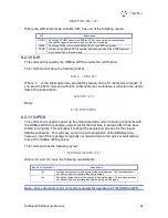
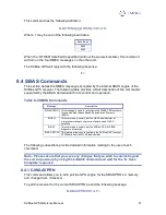
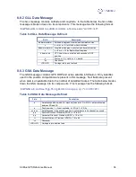
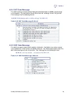
Data Field
Description
$>JGEO
Message header.
Sent=1575.4200
Frequency sent to the digital signal processor
Used=1575.4200
Frequency currently used by the digital signal processor
PRN=prn
WAAS satellite PRN number
Lon=-lon
Longitude of the satellite
El=ele
Elevation angle from the SXBlue GPS antenna to the WAAS
satellite, referenced to the horizon.
Az=az
Azimuth from the SXBlue GPS antenna to the WAAS satellite,
referenced to the horizon.
To monitor this information for dual SBAS satellites, add the ‘,ALL’ variable to the
$JGEO message as follows:
$JGEO[,ALL] <CR><LF>
This will result in the following output messages:
$>JGEO,Sent=1575.4200,Used=1575.4200,PRN=122,Lon=-54,El=9.7,Az=114.0
$>JGEO,Sent=1575.4200,Used=1575.4200,PRN=134,Lon=178,El=5.0,Az=252.6
As can be seen from this output, the first message is identical to the output from the
$JGEO query, however, the second message provides information on the WAAS
satellite not being currently used. Both outputs follow the format in the previous table for
the $JGEO query.
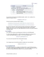
8.4.3 $JRD1
This command is used to request diagnostic information from the SXBlue GPS.
To command the SXBlue GPS to output the diagnostic information message for the
currently used SBAS satellites at a rate of 1 Hz, use the following query:
$JASC,D1,1[,OTHER]<CR><LF>
The receiver will respond with the following data message:
$>
This message may be turned off by setting the update rate to zero as follows:
$JASC,D1,0<CR><LF>
8.4.4 $JASC,RTCM
This command allows you to configure the SXBlue GPS to output RTCM corrections
from SBAS through either SXBlue GPS serial port. The correction data output is RTCM
SC-104 even though SBAS uses a different over-the-air protocol (RTCA).