background image

GPSMAP 700 Series Owner’s Manual 

5

Charts and 3D Chart Views 

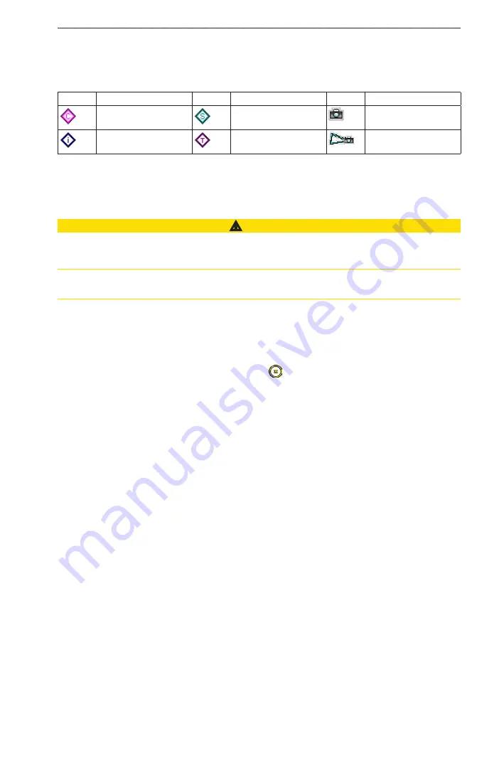
Chart Symbols

BlueChart g2 and BlueChart g2 Vision charts use graphic symbols to denote map features, which follow the 

standards for US and international charts. Some other common symbols you might see include, but are not 

limited to, those shown below.

Icon

Description

Icon

Description

Icon

Description

Current station

Marine services

Overhead photo 

available

Information

Tide station

Perspective photo 

available

Other features common to most charts include depth contour lines (with deep water represented in white), 

intertidal zones, spot soundings (as depicted on the original paper chart), navigational aids and symbols, 

obstructions, and cable areas.

Navigating to a Point on the Chart

 CAUTION

The Auto Guidance feature of the BlueChart g2 Vision data card is based on electronic chart information. That 

data does not ensure obstacle and bottom clearance. Carefully compare the course to all visual sightings and 

avoid any land, shallow water, or other obstacles that may be in your path.
When using Go To, a direct course and a corrected course may pass over land or shallow water. Use visual 

sightings and steer to avoid land, shallow water, and other dangerous objects.

NoTe

: The Fishing chart is available if you use a BlueChart g2 Vision SD card or a BlueChart g2 SD card, or 

if your built-in map supports Fishing charts.
1.  From the Home screen, select 

Charts

.

2.  Select 

Navigation Chart

 or 

Fishing Chart

.

3.  Touch the chart to select the location using the cursor ( ).
4.  Select 

Navigate To

.

5.  Complete an action:

•  Select 

Go To

 to navigate directly to the location.

•  Select 

Route To

 to create a route to the location, including turns (

page 28

).

•  Select 

Guide To

 to use Auto Guidance (

page 21

).

6.  Review the course indicated by the magenta line.

NoTe

: When using Auto Guidance, a gray segment within any part of the magenta line indicates that Auto 

Guidance cannot calculate part of the Auto Guidance line. This is due to the settings for minimum safe 

water depth and minimum safe obstacle height (

page 46

).

7.  Follow the magenta line, steering to avoid land, shallow water, and other obstacles.

Panning the Navigation Chart, Fishing Chart, or Radar Overlay

You can pan away from your present location and to other areas on the Navigation chart, the Fishing chart, or 

the Radar Overlay. 

NoTe

: The Fishing chart is available if you use a BlueChart g2 Vision SD card or a BlueChart g2 SD card, 

or if your built-in map supports Fishing charts. The radar overlay is available when connected to a compatible 

radar.
1.  From the Home screen, select 

Charts

.

2.  Select 

Navigation Chart

Fishing Chart

, or 

Radar overlay

.

3.  Touch and drag the Navigation screen to pan the map.

When you pan past the edge of the map, the screen scrolls forward to provide continuous map coverage.

4.  Select 

Stop Panning

 to stop panning and return the screen to your present location.

Summary of Contents for GPSMAP 740

Page 1: ...GPSMAP 700 series owner s manual...

Page 2: ...right to change or improve its products and to make changes in the content without obligation to notify any person or organization of such changes or improvements Visit the Garmin Web site www garmin...

Page 3: ...ny screen to return to the Home screen Select Menu from any main screen to access additional settings Press and release to adjust the Backlight and Color Mode settings Press and hold to turn the chart...

Page 4: ...a 41 Device Configuration 44 Basic Device Configuration Questions 44 Simulator Mode 44 Turning the Chartplotter On Automatically 44 Display Configuration 45 Navigation Preferences 45 Information about...

Page 5: ...nels GPSMAP 700 Series Front View Power key Automatic backlight sensor SD card slot GPSMAP 700 Series Back View NMEA 2000 connector Power data connector Radar Port External GPS antenna connector Turni...

Page 6: ...t the backlight Select Backlight Auto to allow the chartplotter to adjust the backlight automatically based on ambient light Use the slider bar to manually adjust the backlight Select Backlight to swi...

Page 7: ...upports Fishing charts Sonar sets up and provides sonar information only available with an S series unit such as a GPSMAP 720s page 71 Combinations sets up a split screen displaying chart chart chart...

Page 8: ...sional view from above and behind the boat for a visual navigation aid page 17 Fish Eye 3D provides an underwater view that visually represents the sea floor according to the chart information page 18...

Page 9: ...if your built in map supports Fishing charts 1 From the Home screen select Charts 2 Select Navigation Chart or Fishing Chart 3 Touch the chart to select the location using the cursor 4 Select Navigat...

Page 10: ...vary based on the location or object you selected 4 Complete an action Select Review to view details of objects in the vicinity of the cursor Review does not appear if the cursor is not near an object...

Page 11: ...ge 36 Note Tide station icons are available only if you use a BlueChart g2 Vision SD card page 16 The Fishing chart is available if you use a BlueChart g2 Vision SD card or a BlueChart g2 SD card or i...

Page 12: ...your built in map supports Fishing charts 1 From the Home screen select Charts 2 Select Navigation Chart Fishing Chart Perspective 3D or Mariner s Eye 3D 3 Select a navaid with the cursor An option de...

Page 13: ...hing Chart 3 Select Menu 4 Select Navigation Chart Setup or Fishing Chart Setup 5 Select Chart Appearance 6 Complete an action Select World Map Full to show shaded relief on the chart Select World Map...

Page 14: ...On the Navigation Chart you can turn on spot soundings and set a dangerous depth Spot depths that are equal to or more shallow than the dangerous depth will be indicated by red text 1 From the Home s...

Page 15: ...Chart g2 Vision data card This enables you to view aerial photos of landmarks page 20 Changing the Vehicle Icon You can select a large medium or small boat or triangle as your vehicle icon on the char...

Page 16: ...mit emergency position reports when activated SART transmissions are different than standard AIS transmissions so they look different than standard AIS symbols on the chartplotter Instead of tracking...

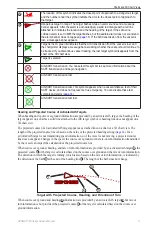
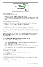
Page 17: ...alerts page 14 AIS SART transmission test lost Heading and Projected Course of Activated AIS Targets When heading and course over ground information are provided by an activated AIS target the heading...

Page 18: ...hart or one 3D chart view are applied to all charts and to all 3D chart views Note The Mariner s Eye 3D chart is available if you use a BlueChart g2 Vision SD card The Fishing chart is available if yo...

Page 19: ...f the safe zone ring to a specified distance from 500 ft to 2 0 nm or from 150 m to 3 0 km or from 500 ft to 2 0 mi 3 Select a distance 4 Select Time To to sound an alarm if AIS determines that a targ...

Page 20: ...ner s Eye 3D view that indicates the course to your destination while you are navigating You can specify the width of the navigation lane Note Mariner s Eye 3D is available with a preprogrammed BlueCh...

Page 21: ...data card only on BlueChart g2 Vision compatible Garmin GPS units or Garmin HomePort You can insert or remove a BlueChart g2 Vision data card page 2 while your chartplotter is on or off Mariner s Eye...

Page 22: ...s in Mariner s Eye 3D It does not affect the safe water depth Auto Guidance setting page 46 or the sonar shallow water alarm setting page 77 1 From the Home screen select Charts Mariner s Eye 3D Menu...

Page 23: ...d by your transducer From the Home screen select Charts Fish Eye 3D Menu Sonar Cone On Showing Suspended Targets From the Home screen select Charts Fish Eye 3D Menu Fish Symbols On Showing Tracks From...

Page 24: ...detail level higher by changing the map zoom detail page 8 1 From the Home screen select Charts Navigation Chart Menu Navigation Chart Setup Photos 2 Complete an action Select Land Only to show standa...

Page 25: ...he height of the tide at the station appears above the station indicator Current direction indicators appear as arrows on the chart The direction of each arrow indicates the direction of the current a...

Page 26: ...en select Combinations 2 Select a combination Customizing the Combination Screen 1 From the Home screen select Combinations 2 Select a combination 3 Select Menu 4 Select the screen you want to customi...

Page 27: ...rlay Numbers 4 Select or to select a data overlay 5 Touch a data field 6 Select a category of data 7 Select the data to be displayed Configuring the Navigation Inset on a Combination Screen The naviga...

Page 28: ...rs Show Compass Tape Using Full screen View You can view the content of any combination screen on the full chartplotter screen 1 From the Home screen select Combinations 2 Select a combination 3 Touch...

Page 29: ...or create a route and follow the course or route You can follow the course or the route on the Navigation chart the Fishing chart Perspective 3D or Mariner s Eye 3D Note The Mariner s Eye 3D chart is...

Page 30: ...ur destination or steer back to the magenta line direct course Creating and Following a New Route Using Route To See Creating and Navigating a Route from Your Present Location page 28 Following a Save...

Page 31: ...all Waypoints From the Home screen select Information User Data Waypoints List Editing a Saved Waypoint 1 From the Home screen select Information User Data Waypoints List 2 Select a waypoint 3 Select...

Page 32: ...tes Each route can contain up to 250 waypoints Creating and Navigating a Route from Your Present Location You can create and immediately navigate a route on the Navigation chart or the Fishing chart W...

Page 33: ...n or another location 1 From the Home screen select Information User Data Routes New Route Use Chart 2 Select the starting point of the route 3 Select Add Turn to mark the starting point of the route...

Page 34: ...ute near the destination point that was used when the route was created Select Offset to navigate parallel to the route offset from it by a specific distance page 35 5 Touch the waypoint that you want...

Page 35: ...dit Track 4 Complete an action Select Name enter the new name and select Done Select Track Color and select a color Saving a Track as a Route 1 From the Home screen select Information User Data Tracks...

Page 36: ...e Track Options Interval Interval 2 Complete an action Select Distance to record the track based on a distance between points select Change and enter the distance Select Time to record the track based...

Page 37: ...reen select Where To Offshore Services 2 Select the marine service category to which you want to navigate The chartplotter shows a list of the 50 nearest locations and the distance and bearing to each...

Page 38: ...d is based on electronic chart information That data does not ensure obstacle and bottom clearance Carefully compare the course to all visual sightings and avoid any land shallow water or other obstac...

Page 39: ...the route from the starting point used when the route was created to the right of the original route Select Backward Port to navigate the route from the destination point used when the route was creat...

Page 40: ...ly viewed tide station and for the present date and time From the Home screen select Information Tides Tide Station Information Viewing Information about a Nearby Tide Station 1 From the Home screen s...

Page 41: ...select Information Currents Nearby Stations 2 Select a station Configuring Current Station Information You can indicate the date of current station information to be viewed and you can view the inform...

Page 42: ...nge the time in 1 hour intervals Viewing Tide Current and Celestial Information from the Navigation Chart 1 From the Home screen select Charts Navigation Chart 2 Select an area near a tide current or...

Page 43: ...ct Information Dashboard Gauges Engine Menu Gauge Setup Status Alarms On Customizing Engine and Fuel Gauge Status Alarms 1 From the Home screen select Information Dashboard Gauges Engine Menu Gauge Se...

Page 44: ...Customizing Gauge Limits See Customizing Engine and Fuel Gauge Limits page 38 Activating and Customizing Gauge Alarms See Activating Engine and Fuel Gauge Status Alarms page 39 and Customizing Engine...

Page 45: ...t From the Home screen select Information Dashboard Gauges Compass Environmental Data Wind Gauges Viewing Wind Gauges From the Home screen select Information Dashboard Gauges Wind Selecting True or Ap...

Page 46: ...lete an action Select Speed Display GPS Speed to display the speed of the vessel based upon GPS readings Select Speed Display Water Spd to display the speed of the vessel based upon the reading from a...

Page 47: ...Dashboard Gauges Environment Menu 2 Complete an action Select Alignment North Up to set the top of the wind gauge to a north heading Select Alignment Head Up to set the wind gauge to rotate to match...

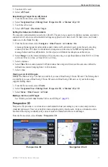
Page 48: ...GPS receiver is turned off Any satellite signal strength bars shown are simulations and do not represent the strength of actual satellite signals Simulator mode turns the GPS receiver off for use ind...

Page 49: ...mprove the accuracy of the autopilot when navigating a route or an Auto Guidance line with many frequent turns or at higher speeds For straighter routes or slower speeds lowering this value can improv...

Page 50: ...ance setting Nearest Near Normal Far or Farthest are relative not absolute To ensure that the Auto Guidance line is placed the appropriate distance from shore you can assess the placement of the Auto...

Page 51: ...Heading 2 Complete an action Select Auto Mag Var automatic magnetic variation to set the magnetic declination for your location automatically Select True to set true north as the heading reference Se...

Page 52: ...ers Select Temperature and select Fahrenheit F or Celsius C Select Distance and select Miles Kilometers Nautical nm ft or Nautical nm m Select Speed Vessel Speed and select Miles Per Hour Kilometers P...

Page 53: ...own only when the boat is navigating to a destination 1 From the Home screen select Charts 2 Select a chart or a 3D chart view 3 Select Menu 4 Complete an action Select Navigation Chart Setup Overlay...

Page 54: ...rd The Fishing chart is available if you use a BlueChart g2 Vision SD card or a BlueChart g2 SD card or if your built in map supports Fishing charts 1 From the Home screen select Charts 2 Select Navig...

Page 55: ...e to arrival Select Change Time if Activation is set to Time or Change Distance if Activation is set to Distance to indicate how long before arrival in minutes or how far before arrival in units of di...

Page 56: ...pSource data to a chartplotter you must prepare the memory card by inserting it into the chartplotter and allowing the chartplotter to place a file on it This file provides information to HomePort or...

Page 57: ...Transfer NMEA 2000 2 Complete an action Select Clone User Data to transfer data from the chartplotter to the other chartplotters connected to the network Existing data is overwritten on those chartplo...

Page 58: ...e radar warms up and a countdown is provided to alert you when the radar is ready NOTE As a safety feature the radar enters standby mode after it warms up This gives you an opportunity to verify that...

Page 59: ...nable a guard zone in Sentry mode which identifies a safe zone around your boat Radar Mode Compatible Radar GMR 20 21 40 41 GMR 18 18 HD 24 24 HD GMR 404 406 GMR 604 xHD 606 xHD 1204 xHD 1206 xHD Crui...

Page 60: ...de the radar switches to full time transmission and disables all guard zones Showing Harbor Mode From the Home screen select Radar Harbor Harbor Mode Offshore Mode Offshore mode is the standard radar...

Page 61: ...To help conserve power you can indicate the radar standby time and the transmit time to implement periodic radar signal transmissions at set intervals 1 From the Home screen select Radar Sentry Menu...

Page 62: ...tup Adjust Guard Zone Move Guard Zone Circle 2 Touch and drag the location of the outer guard zone circle 3 Select Corner 2 4 Touch and drag the location of the inner guard zone corner 5 Select Circle...

Page 63: ...the VRM appears as a circle that is centered on the present location of your boat and the EBL appears as a line that begins at the present location of your boat and intersects the VRM The point of int...

Page 64: ...the Home screen select Radar 2 Select a radar mode 3 Touch a location 4 Select Create Waypoint Showing Waypoints on the Radar Screen You can show waypoints that are within the range shown on the Radar...

Page 65: ...the destination point used when the route was created to the left of the original route Select Backward Starboard to navigate the route from the destination point used when the route was created to t...

Page 66: ...ing In and Out on the Radar Overlay Zooming while panning the map only affects the zoom scale of the map The radar range remains the same Zooming while the map is locked on the boat not panning affect...

Page 67: ...mode are applied to every other radar mode and to the Radar Overlay When using a GMR 604 xHD 606 xHD 1204 xHD or 1206 xHD radar the gain FTC rain clutter and sea clutter settings configured for use i...

Page 68: ...ne radar mode may or may not be applied to other radar modes or to the Radar Overlay page 63 1 From the Home screen select Radar 2 Select Cruising Harbor Offshore or Sentry mode 3 Select Menu Gain 4 S...

Page 69: ...to other radar modes or to the Radar Overlay page 63 1 From the Home screen select Radar 2 Select Harbor Offshore or Sentry mode 3 Select Menu Noise Rejection FTC Off Restoring the Default Rain Clutt...

Page 70: ...tting Note Depending upon the radar in use the crosstalk setting configured for use in one radar mode may or may not be applied to other radar modes or to the Radar Overlay page 63 1 From the Home scr...

Page 71: ...how the destination data appears Showing the Compass Tape on the Radar Screen The compass tape appears in a row across the top of the radar screen It shows the present heading and an indicator that sh...

Page 72: ...t Radar Radar Setup Appearance Nav Lines Show Radar Scanner and Antenna Settings Setting the Antenna Rotation Speed Note You can set the rotation speed for GMR 18 18 HD 24 24 HD 404 406 604 xHD 606 xH...

Page 73: ...ting a Waypoint Label Type You can select the type of labels shown with waypoints on the Radar Overlay 1 From the Home screen select Charts Radar Overlay Menu Waypoints Tracks Waypoint Display 2 Selec...

Page 74: ...Showing and Configuring the Heading Line The heading line is an extension drawn on the map from the bow of the boat in the direction of travel You can configure the appearance of the heading line on t...

Page 75: ...s Depth water speed and unit voltage Suspended target Bottom Range GPS speed and GPS heading Transducer frequency Setting the Zoom Level on the Full screen View You can zoom in to a section of the ful...

Page 76: ...frequency Split frequency Sonar View In the split frequency sonar view the left side of the screen shows a full view graph of 200 kHz frequency sonar data and the right side of the screen shows a ful...

Page 77: ...to set the depth range scale Increasing the depth range scale allows you to view more variation in depth Decreasing the depth range scale allows you to view more detail in the variation The present de...

Page 78: ...sducer Temperature Log Waypoints on the Sonar Screen Pausing the Sonar Display 1 From the Home screen select Sonar 2 Select a sonar view 3 Select Menu Pause Sonar Creating a Waypoint on the Sonar Scre...

Page 79: ...settings 1 From the Home screen select Sonar Sonar Setup Pic Advance 2 Select a picture advance setting Showing Overlay Numbers You must have a water speed sensor or a speed capable transducer to show...

Page 80: ...nar view 3 Select Menu Gain 4 Complete an action Select Auto to allow the chartplotter to adjust the gain automatically Select Up or Down to increase or decrease the gain manually 5 Select Done Adjust...

Page 81: ...he depth is less than the specified value 3 Enter the depth that triggers the shallow water alarm 4 Select Done 5 Select Deep Water On to set an alarm to sound when the depth is greater than the speci...

Page 82: ...positive or a negative number based on the location of the transducer 4 Select Done Setting the Water Temperature Offset You must have a NMEA 0183 water temperature sensor or a temperature capable tr...

Page 83: ...set up and send individual routine call details to your Garmin VHF radio page 83 X When you initiate a man overboard distress call from your radio the chartplotter shows the man overboard screen and...

Page 84: ...ting a Waypoint at the Position of a Vessel in Distress See Creating a Waypoint at the Position of a Tracked Vessel page 81 Editing Information in a DSC Call Report See Editing Information in a Positi...

Page 85: ...me screen select Information Other Vessels DSC List 2 Select a position report call 3 Select Navigate To 4 Select Go To or Route To page 25 Creating a Waypoint at the Position of a Tracked Vessel 1 Fr...

Page 86: ...Eye 3D chart is available if you use a BlueChart g2 Vision SD card The Fishing chart is available if you use a BlueChart g2 Vision SD card or a BlueChart g2 SD card or if your built in map supports F...

Page 87: ...ds 6 8 9 10 13 15 16 17 67 68 69 71 72 73 or 77 The default channel is 72 If you select a different channel the chartplotter uses that channel for subsequent calls until you call using another channel...

Page 88: ...moved more than about 500 mi 800 km since it was turned off Reacquisition 1 sec Update Rate 1 sec continuous Accuracy GPS 33 ft 10 m 95 typical DGPS 10 16 ft 3 5 m 95 typical WAAS EGNOS accuracy Velo...

Page 89: ...ocations You can view the relative position of GPS satellites in the sky From the Home screen select Configure System GPS Skyview Using WAAS EGNOS WAAS in North America or EGNOS in Europe can provide...

Page 90: ...and heading sentences Configuring NMEA 0183 Output Sentences You can configure how the chartplotter sees NMEA 0183 output sentences 1 From the Home screen select Configure Communications NMEA 0183 Set...

Page 91: ...orted NMEA 2000 PGN numbers see the GPSMAP 700 Series Installation Instructions Viewing a List of NMEA 2000 Network Devices You can view the devices connected to the NMEA 2000 network 1 From the Home...

Page 92: ...ing occurs when a chartplotter takes NMEA 0183 data it receives from any source formats it into NMEA 2000 data and sends it over the NMEA 2000 bus 1 From the Home screen select Configure Communication...

Page 93: ...Garmin Ltd and its subsidiaries Garmin grant you a limited license to use the software embedded in this device the Software in binary executable form in the normal operation of the product Title owne...

Page 94: ...user data 28 30 31 32 clock alarm 51 close hauled wind gauge 42 clutter cross talk 63 default settings 63 FTC 63 65 radar type 63 rain 63 65 sea 63 64 65 collision alarm 12 15 58 color mode 2 color of...

Page 95: ...ht sectors 11 M magnetic heading 8 43 67 magnetic variation 47 man overboard creating from a navigation screen 27 creating from main menu 3 deleting 28 from VHF radio 80 Mariner s Eye 3D AIS 15 data b...

Page 96: ...llel to 35 61 present location 28 radar 60 turns 28 29 45 viewing list of 29 waypoints 29 Where To 25 Route To 26 28 33 S safe depth 18 46 safe height 46 safe zone collision alarm 15 58 SART 12 satell...

Page 97: ...iew 72 spot depth soundings 10 suspended targets 19 75 symbols 5 10 system information 85 T tanks labeling 87 temperature log 73 tide station indicators configuring 8 tide stations indicators 8 21 nea...

Page 98: ......

Page 99: ......

Page 100: ...rmin Ltd or its subsidiaries Garmin International Inc 1200 East 151st Street Olathe Kansas 66062 USA Garmin Europe Ltd Liberty House Hounsdown Business Park Southampton Hampshire SO40 9LR UK Garmin Co...

Reviews: