Backlight Timeout
: Adjusts the length of time before the
backlight turns off.
Color Mode
: Sets the device to display day or night colors. You
can select
Auto
to allow the device to automatically set day
or night colors based on the time of day.
Screen Capture
: Allows you to save the image on the device
screen.
Changing the Start Notice
This feature automatically detects when your device has
acquired satellites and is moving. It is a reminder to start the
timer so you can record your ride data.
1
From the home screen, select >
System
>
Start Notice
>
Start Notice Mode
.
2
Select an option:
• Select
Once
.
• Select
Repeat
>
Repeat Delay
to change the amount of
time to delay the reminder.
Changing the Data Storage Location
1
From the home screen, select >
System
>
Data
Recording
>
Record To
.
2
Select an option:
• Select
Internal Storage
to save your data to the device
memory.
• Select
Memory Card
to save your data to an optional
memory card.
Changing the Units of Measure
You can customize units of measure for distance and speed,
elevation, weight, position format, and time format.
1
From the home screen, select >
System
>
Units
.
2
Select a measurement type.
3
Select a unit of measure for the setting.
Customizing the User Profile
When you first use the device, you are prompted to enter your
gender, age, and weight. You can update these settings at any
time. The device uses this information to calculate accurate ride
data.
From the home screen, select >
System
>
User Profile
.
Changing the Device Language
From the home screen, select >
System
>
Language
.
Setting the Device Tones
From the home screen, select >
System
>
Tones
.
Restoring the Factory Settings
You can reset all of the settings you configured in the initial
setup.
1
From the home screen, select >
System
>
Factory
Reset
.
2
Follow the on-screen instructions.
Time Zones
Each time you turn on the device and acquire satellites, the
device automatically detects your time zone and the current
time of day.
Device Information
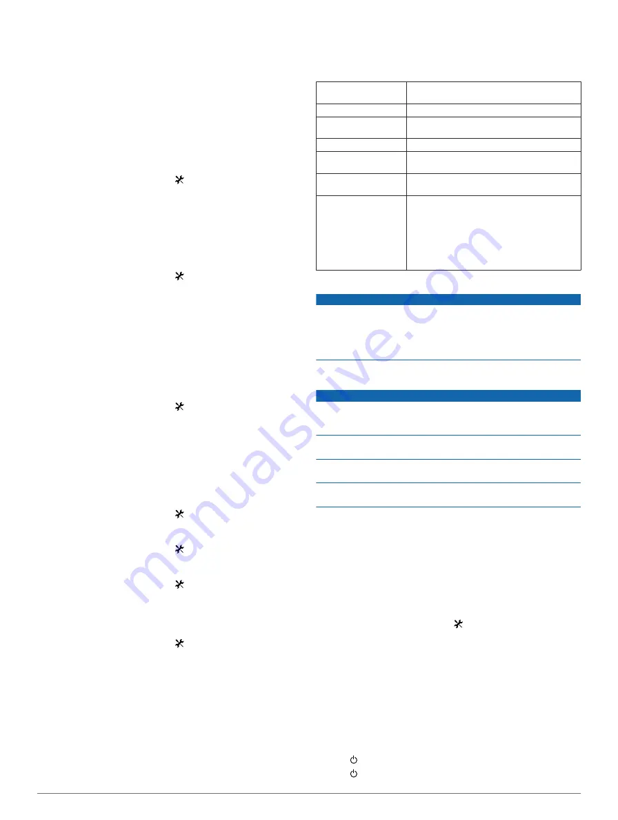
Edge Specifications
Battery type
1100 mAh rechargable, built-in lithium-ion
battery
Battery life
15 hours, typical usage
Optional external
battery (accessory)
20 hours, typical usage
Water resistance
IPX7
Operating temperature
range
From -4º to 140ºF (from -20º to 60ºC)
Charging temperature
range
From 32º to 113ºF (from 0º to 45ºC )
Bands (O-rings) for the
standard mount
Two sizes:
• 1.3 × 1.5 × 0.9 in. AS568-125
• 1.7 × 1.9 × 0.9 in. AS568-131
NOTE:
Use Ethylene Propylene Diene
Monomer (EPDM) replacement bands only.
Go to
, or contact your
Garmin® dealer.
About IPX7
NOTICE
The device is waterproof to IEC Standard 60529 IPX7. It can
withstand immersion in 1 meter of water for 30 minutes.
Prolonged submersion can cause damage to the device. After
submersion, be certain to wipe dry and air dry the device before
using or charging.
Device Care
NOTICE
Do not store the device where prolonged exposure to extreme
temperatures can occur, because it can cause permanent
damage.
Never use a hard or sharp object to operate the touch screen,
or damage may result.
Avoid chemical cleaners and solvents that can damage plastic
components.
Secure the weather cap tightly to prevent damage to the mini-
USB port.
Cleaning the Device
1
Wipe the device using a cloth dampened with a mild
detergent solution.
2
Wipe it dry.
Viewing Satellites
The satellite page shows your current GPS satellite information.
For more information about GPS, go to
.
From the home screen, select >
System
>
GPS
>
View
Satellites
.
GPS accuracy appears at the bottom of the page. The green
bars represent the strength of each satellite signal received (the
number of the satellite appears below each bar).
Troubleshooting
Resetting the Device
If the device stops responding, you may need to reset it. This
does not erase any of your data or settings.
1
Hold for 10 seconds.
2
Hold for one second to turn on the device.
6
Device Information