background image

44 

Astro and DC 40 Owner’s Manual

GPS Applications

2.  To scroll through all turn previews, 

press up or down on the 

Rocker

Press 

ENTER

 to view an 

individual turn.

Using Active route

To preview a list of the turns 

while navigating a route:

1.  While navigating a route on the 

Map page, press 

MENU

 > 

MENU


Advanced

 > 

GPS Applications


Active Route

.

2.  Select a turn to view an individual 

turn.

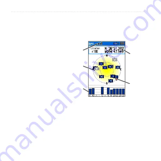
Using the Satellite Page

The Satellite page shows the receiver 

status, the satellite locations, the 

satellite signal strength, and your 

current location when the unit receives 

signals from at least three satellites.

To open the Satellite page:

  Press 

MENU

 > 

MENU

 > 

Advanced

 > 

GPS Applications

 > 

Satellite

.

Headng bug 

(ndcates your 

drecton of 

movement)

Satellte 

sgnal 

strength

Your 

locaton

Recever 

status

Satellite Page

Satellte 

locaton

To change satellite options:

  On the Satellite page, press 

MENU

.

Use With GPS Off

 (or 

On

)–turns the GPS receiver off 

or on.

Summary of Contents for Astro DC 40

Page 1: ...GPS enabled dog tracking Astro and DC 40 draft owner s manual New cover and photo requested...

Page 2: ...igation to notify any person or organization of such changes or improvements Visit the Garmin Web site www garmin com for current updates and supplemental information concerning the use and operation...

Page 3: ...s 5 Calibrating the Astro Compass 6 Operating the Astro 6 Manual Conventions 7 On Screen Messages 7 Dog Tracking 8 Communicating with the DC 40 8 Tracking a Dog 10 Main Menu 14 Mark Location 15 Averag...

Page 4: ...e Sunset 42 Hunting Almanac 43 Games 43 Settings 44 System Setup 44 Dog List Setup 45 Dog Alerts Setup 45 Display Setup 45 Tones Setup 46 Main Menu Setup 46 Map Setup 46 Routing Setup 49 Geocache Setu...

Page 5: ...gs and other important information Setting Up the Device When using your device the first time follow the setup instructions in the Quick Start Manual Device Overview Power key Display Keypad Belt cli...

Page 6: ...Manual Introduction Battery charging port Keypad DOG Press to view the Dog Tracker page MARK Press to mark your current location BACK Press to cancel data entry or return to the previous menu or page...

Page 7: ...he DC 40 battery life turn the unit off when you are not tracking a dog or decrease the update rate page 11 Turning the Astro On Manual Conventions Press Use the keys on the device Select Use the Rock...

Page 8: ...etects a signal for example a DC 40 on the channel it is receiving Indicates the remaining battery power Indicates the Astro is powered by an external source On Screen Messages When an on screen messa...

Page 9: ...Astroand DC 40 Owner s Manual Introduction 3 Press ENTER to select a brightness level and close the menu...

Page 10: ...ructions for adding a new dog on page 10 to establish communications with the Astro Viewing the Dog Status Press DOG to view the Dog Tracker page Note The DC 40 does not transmit its location to the A...

Page 11: ...t name such as Dog or Dog 1 to every dog DC 40 linked to it Changing the Name of the Dog 1 On the Dog Information page highlight the Name field and press ENTER 2 Use the Rocker and ENTER to spell the...

Page 12: ...ansfers detailed tracks from the DC 40 to a computer page 71 Delete Dog Unit Track deletes the track log for the dog Change Dog Unit Type allows you to identify the dog type so that the appropriate do...

Page 13: ...the dog pointer is shortened When you are close to the dog the dog pointer may be inaccurate Dog Status Icons Sitting Running On Point Treed Unknown The Unknown status symbol indicates that the DC 40...

Page 14: ...or the selected dog Pause or Resume All Tracking pauses tracking of all dogs Calibrate Compass calibrates the compass page 5 View Dog List opens the Dog List to add or remove dogs Small Numbers or Big...

Page 15: ...u through the process of resolving the conflict If necessary you can manually assign a new ID number to a dog When possible you should allow the Astro to automatically assign IDs Resolving the Dog Sig...

Page 16: ...e signals Keeping an unobstructed line of sight between you and your dog s DC 40 produces the best communication signal Obstructed radio waves result in a poor signal To achieve the best line of sight...

Page 17: ...Astroand DC 40 Owner s Manual 13 Dog Tracking Line of Sight Radio Communication BEST GOOD POOR Line of Sight Radio Communication...

Page 18: ...ARK 2 Select a name and hunting related symbol to describe the location and press ENTER Note The Mark Covey option allows you to enter the estimated number of birds flushed and the number taken 3 To e...

Page 19: ...dvanced Find Marked Locations 3 Select the location you want to edit 4 Enter your changes using the on screen keypad Moving a Marked Location on the Map 1 Press MENU MENU 2 Select Advanced Find Marked...

Page 20: ...cy you want select Save OK Projecting a Location You can create a new location by projecting the distance and bearing from a marked location to a new location To project a location 1 Press MENU MENU A...

Page 21: ...the Rocker to move the map pointer away from your current location As you pan past the edge of the current map display the screen scrolls to provide continuous map coverage Press IN and OUT to change...

Page 22: ...ults returns map settings to the default settings Data Fields When navigating on the Map page you can display up to four data fields at the top of the page to provide travel and navigational informati...

Page 23: ...nual 19 Map 2 Move the arrow to the point you want to measure from and press ENTER A push pin marks the beginning point 3 Move the arrow to another point REF marks the ending point The distance betwee...

Page 24: ...only those items near your current location or the map pointer if active Finding a Location by Name 1 Press MENU MENU Advanced Find 2 Select the type of item you want to find 3 Press MENU Find by Nam...

Page 25: ...TER to show a list of items near the new map location To find a marked location 1 Press MENU MENU Advanced Find Marked Locations 2 Select a location To find a geocache 1 Press MENU MENU Advanced Find...

Page 26: ...om the list ENTER for more information about the service Item Information Page Options The Options menu for each information page contains options for using a Find item as a tool for navigation To use...

Page 27: ...using addresses or intersections Select the All Points of Interest category to locate a nearby restaurant lodging landmark or other public building To find an address or intersection 1 Press MENU MENU...

Page 28: ...tion appear 2 Press MENU to narrow your search 3 Select the item you want from the list ENTER to open the information page for the item POI Loader and Custom Points of Interest Create your own categor...

Page 29: ...tes page 38 Highway page 41 Proximity page 42 Turn Preview page 43 Active Route page 44 Satellite page 44 Using the Trip Computer The Trip Computer page provides travel data such as current speed dist...

Page 30: ...press MENU Change Data Fields 2 Use the Rocker to select a field 3 Press ENTER select an option ENTER Using the Compass Page The Compass page guides you to your destination with a compass display and...

Page 31: ...line leading to the destination The bearing pointer points to the destination regardless of the direction you are moving If the bearing pointer is pointing in your direction of travel you are travelin...

Page 32: ...ion to compensate for deviation and to get back on course This is most useful if you are navigating on water or where there are no major obstacles in your path It also helps you avoid hazards to eithe...

Page 33: ...the compass page 5 Restore Defaults restores compass settings to the default settings To change the type of data on the compass 1 On the Compass page press MENU Change Data Fields 2 Use the Rocker to...

Page 34: ...compass outdoors Do not stand near objects that influence magnetic fields such as cars buildings or overhead power lines Calibrate the Astro electronic compass the first time you use it after long per...

Page 35: ...plays the current elevation the rate of your ascent or descent elevation changes over distance or time or pressure changes over time To open the Altimeter page Press MENU MENU Advanced GPS Application...

Page 36: ...view altitude points on the Map page 1 On the Altimeter page use the Rocker to move the red crosshairs to the point you want to view on the map 2 Press ENTER The point is marked by the map pointer wit...

Page 37: ...ecording new data To set the zoom ranges for the altimeter plot 1 On the Altimeter page press MENU Zoom Ranges OR Press up or down on the Rocker 2 Press up or down on the Rocker to set the zoom range...

Page 38: ...ter the elevation or barometric pressure OK Using Tracks A track is a recording of your path and of the path of your dogs The track log contains information about points along the recorded path includ...

Page 39: ...ate track but fills up the track log faster Interval specifies a distance a time or a frequency Color selects the color of the track To change the color of a dog s track use the color option on the Sa...

Page 40: ...e beginning point and press ENTER 3 Use the Rocker to move the map pointer to the ending point and press ENTER OK To view a track on the map On the Tracks page select Save Yes Map The track appears on...

Page 41: ...he top of the page and the distance from the Begin point and the End point appear at the bottom 2 While scrolling press ENTER to show the highlighted point on the map To set the zoom ranges for the tr...

Page 42: ...o navigate back to the selected point using available roadways or Follow Track to retrace your original path of travel To mark a location on a saved track 1 With a saved track shown on the map move th...

Page 43: ...f the Find menu categories for the first point on the route 4 Select the first point on the route 5 Select Use 6 To add more points to the route repeat steps 2 through 5 7 Select Navigate Route on the...

Page 44: ...Save saves the point as a location Map shows the point on the Map page Go To navigates to the point To delete a route On the Routes page select a saved route Delete To delete all routes On the Routes...

Page 45: ...ute Reverse Route reverses the order of the points in the saved route Profile creates a vertical profile of the route when MapSource DEM U S Topo map data is used Copy Route makes a copy of the route...

Page 46: ...alculate recalculates the path to a destination Data Fields selects 2 3 or 4 data fields that appear on the Highway page Change Data Fields selects the type of data you want to show in the data fields...

Page 47: ...rn proximity alarms off 1 On the Proximity page select Proximity Alarm Tones 2 Select an alarm field to view the list of tones 3 Select the desired tone ENTER 4 Select Proximity Alarms to activate the...

Page 48: ...dividual turn Using the Satellite Page The Satellite page shows the receiver status the satellite locations the satellite signal strength and your current location when the unit receives signals from...

Page 49: ...ing at the top of the display Multicolor or Single Color selects whether each satellite appears in a different color or the same color New Location select if you have moved the unit more than 600 mile...

Page 50: ...Hunting Almanac page 51 Games page 48 Calendar The calendar can record locations on specific days and provide sunrise sunset and hunting almanac information Opening the Calendar Press MENU MENU Advanc...

Page 51: ...rise Sunset or View Hunting Almanac Calculator The Astro has a standard calculator and a scientific calculator Using the Calculators The device also has two calculator applications 1 Press MENU MENU A...

Page 52: ...ess MENU MENU View Sunrise Sunset 2 Select an option Select Date to change the date The on screen keypad appears Select Location to change the location Select Time to view positions of the sun and moo...

Page 53: ...Astroand DC 40 Owner s Manual 49 Accessories Beast Hunt Some games use GPS during the game Most games contain a tutorial To open the Games list Press MENU MENU Advanced Accessories Games...

Page 54: ...ce Battery Type selects the battery type alkaline NiMH or lithium External Power Lost selects whether the Astro stays on or turns off when external power is removed Proximity Alarms turns all proximit...

Page 55: ...e Rocker to select an alert ENTER Off or On On Point Alert indicates that the dog is on point Treed Alert indicates that the dog has treed quarry and has confined its own movements to a small area for...

Page 56: ...select tones Press MENU MENU Advanced Settings Tones 1 Select a tone ENTER 2 Select an option The tone sounds 3 Press ENTER to select the tone Main Menu Setup You can move delete or add items to the m...

Page 57: ...ay Below sets the map scale at which Track Up is used At scales above the setting map orientation is set to North Up Auto Zoom sets the map scale to include the beginning and ending points of a route...

Page 58: ...topographic marine charts and MapSource maps appear Use the Rocker ENTER to show the detailed map on the map display or turn it off Press MENU to select options for hiding or showing maps Map Setup Ma...

Page 59: ...route that overlays the roads on the map Off Road creates a direct line from your current location to your destination To select the method your Astro uses to calculate road routes On the Routing Set...

Page 60: ...Select Calculation Method Quickest Calculation calculates the route the quickest but it might not produce the best route Quick Calculation takes more time to calculate but generates a better quality r...

Page 61: ...or Found Select a symbol for caches that you are looking for or have found 3 Select Calendar Entry When Found Yes to make an entry on the calendar page 46 when a cache is found Marine Alarms Setup To...

Page 62: ...e system to use for location readings Map Datum sets the coordinate system in which a given location reading appears Do not change the map datum unless you are using a map or chart that specifies a di...

Page 63: ...o a compass heading when for more than time is exceeded for more than sets the time to switch to a compass heading Calibration Setup Redundancy To calibrate the compass 1 Press MENU MENU Advanced Sett...

Page 64: ...corrected by the GPS receiver To set the altimeter to function as a standard barometer 1 Press MENU MENU Advanced Settings Altimeter 2 Select Barometer Mode Fixed Elevation used when stationary allowi...

Page 65: ...Support if you have any questions about this product In the USA go to www garmin com support or contact Garmin USA by phone at 913 397 8200 or 800 800 1020 In the UK contact Garmin Europe Ltd by phone...

Page 66: ...rap through the slot on the back of the unit 2 Route the strap through the loop and pull the end of the strap Belt clip button installation tighten the button securely by turning it clockwise Belt cli...

Page 67: ...0 240 pixels with backlighting Water resistance Both the Astro and the DC 40 are water resistant IEC 529 IPX7 Temperature Range Astro from 4 F to 158 F from 20 C to 70 C DC 40 from 4 F to 140 F from 2...

Page 68: ...Resolution 1 ft 0 3 m Range from 2 000 ft to 30 000 ft from 610 to 9144 m Interfaces USB for computer interface Data Storage Life Indefinite no memory battery required Map Storage microSD card capacit...

Page 69: ...ransferring Data Before connecting your Astro to a computer install the USB drivers contained in the MapSource Trip and Waypoint Manager software that came with your Astro Follow the instructions for...

Page 70: ...ing centers and entertainment and you can retrieve addresses and phone numbers for any listed location To achieve the best terrain details when hunting use Garmin U S Topo maps The amount of data tran...

Page 71: ...POIs 1 Remove the battery cover by turning the D ring 1 4 turn counterclockwise and pulling up 2 Slide up and pull out the metal cover 3 Align the metal contacts and place the card in the slot MicroS...

Page 72: ...ble click on My Computer Windows computer to observe a new Removable Disk Drive listed Note If you have several network drives mapped to your computer Windows may experience difficulty assigning a dri...

Page 73: ...tro from your computer Updating Astro software To update software on the Astro 1 Install Garmin MapSource Trip and Waypoint Manager Follow the instructions for installation and operation provided with...

Page 74: ...Information page page 7 on the Astro 6 Press MENU Upgrade Dog Unit and follow on screen instructions 7 Follow the instructions for using WebUpdater or click Download located under Unit Software and f...

Page 75: ...5 Press MENU Transfer Dog Unit Track ENTER Wait until the track data is buffered in to your Astro and Ready to communicate with PC appears 6 Go to MapSource and click the Tracks tab on the left side o...

Page 76: ...1 meter of water for 30 minutes Prolonged submersion can cause damage to the units After immersion be certain to wipe and air dry the units before using or charging Storage Do not store the Astro or D...

Page 77: ...3 Replace the battery cover Selecting the Battery Type 1 Press MENU twice to open the main menu 2 Select Advanced Settings System Battery Type 2 Select Alkaline Lithium or Rechargeable NiMH Long Term...

Page 78: ...these guidelines are not followed the internal lithium ion battery may experience a shortened life span or may present a risk of damage to the DC 40 fire chemical burn electrolyte leak or injury Conta...

Page 79: ...Do not leave the DC 30 where a dog may attempt to chew on it If the battery cell is punctured electrolyte can be released that can be harmful to the dog Long Term DC 40 Battery Storage The normal lon...

Page 80: ...ght treaties You further acknowledge that the structure organization and code of the Software are valuable trade secrets of Garmin and that the Software in source code form remains a valuable trade se...

Page 81: ...by turning the equipment off and on the user is encouraged to try to correct the interference by one of the following measures Reorient or relocate the receiving antenna Increase the separation betwe...

Page 82: ...surements NCRP Report 86 International Commission on Non Ionizing Radiation Protection ICNIRP 1996 Those standards were based on comprehensive and periodic evaluations of the relevant scientific liter...

Page 83: ...ker These recommendations are consistent with the independent research by and recommendations of Wireless Technology Research Persons with pacemakers should ALWAYS keep the radio more than six inches...

Page 84: ...tices so require Commercial Aircraft Many commercial airlines prohibit the use of FRS GMRS radios on board Switch OFF your radio before boarding an aircraft or check the airline rules Blasting Areas T...

Page 85: ...Appendix liquefied petroleum gas such as propane or butane areas where the air contains chemicals or particles such as grain dust or metal powders and any other area where you would normally be advise...

Page 86: ...void 50 B backlight level 4 45 backlight timeout 45 barometer mode 53 battery installation 2 life 55 power remaining 7 type 44 warnings iv bearing pointer 26 below 47 belt clip 2 big numbers dog track...

Page 87: ...g alerts 45 dog information page 9 dog list setup 45 dog status 11 dog tracker page 8 dog tracks transferring 59 E EGNOS 44 elevation vert speed 52 elevation GPS 40 ENTER key 3 exits finding 21 extern...

Page 88: ...page 48 marine page 49 points page 48 text page 48 tracks page 47 MapSource 57 marine alarms setup 51 colors 49 setup 51 marked location adding 15 averaging 16 editing 16 moving 16 projecting 16 mark...

Page 89: ...i remove points 42 reset altimeter 30 trip computer 25 restore defaults system settings 44 trip computer page 25 resume all tracking 12 resume navigation 17 rocker key 3 route points 35 routes 34 cop...

Page 90: ...roSD card 57 transferring dog tracks 59 trip computer page 24 turn preview page 38 U units of measure 52 units setup 52 updating software Astro 58 DC 30 59 upgrade dog unit 10 USB drivers 56 use map d...

Page 91: ......

Page 92: ...www garmin com 2010 Garmin Ltd or its subsidiaries Garmin International Inc 1200 East 151st Street Olathe Kansas 66062 USA Garmin Europe Ltd Liberty House Hounsdown Business Park Southampton Hampshire...

Reviews: