background image

AQUAMAP™ 10x2/12x2 SERIES

9

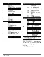
NMEA 2000 PGN Information

Type

PGN

Description

Transmit and receive 059392 ISO acknowledgment

059904 ISO request
060928 ISO address claim
126208

NMEA: Command, request, and acknowledge group 

function

126464

Transmit and receive PGN list group function

126996 Product information
127250 Vessel heading
128259

Speed: Water referenced

128267 Water depth
129025

Position: Rapid update

129026

COG and SOG: Rapid update

129029

GNSS position data

129540

GNSS satellites in view

130306 Wind data
130312 Temperature

Transmit

127258 Magnetic variance
129283 Cross track error
129284 Navigation data
129285 Navigation route and waypoint info

Receive

065030

Generator average basic AC quantities (GAAC)

126992 System time
127488

Engine parameters: Rapid update

127489

Engine parameters: Dynamic

127493

Transmission parameters: Dynamic

127504 AC output status
127505 Fluid level
127508

Battery status

129038 AIS class A position report
129039

AIS class B position report

129040

AIS class B extended position report

129539

GNSS DOPs

129794 AIS class A static and voyage related data
129809

AIS class B “CS” static data report, part A

129810

AIS class B “CS” static data report, part B

130310

Environmental parameters

130311

Environmental parameters (obsolete)

130313 Humidity
130314 Actual pressure

NMEA 0183 Information

Type

Sentence

Description

Transmit

GPAPB

APB: Heading or track controller
(autopilot) sentence “B”

GPBOD

BOD: Bearing (origin to destination)

GPBWC

BWC: Bearing and distance to waypoint

GPGGA

GGA: Global positioning system fix data

GPGLL

GLL: Geographic position (latitude and

longitude)

GPGSA

GSA: GNSS DOP and active satellites

GPGSV

GSV: GNSS satellites in view

GPRMB

RMB: Recommended minimum navigation

information

GPRMC

RMC: Recommended minimum specific
GNSS data

GPRTE

RTE: Routes

GPVTG

VTG: Course over ground and ground speed

Type

Sentence

Description

GPWPL

WPL: Waypoint location

GPXTE

XTE: Cross track error

PGRME

E: Estimated error

PGRMM

M: Map datum

PGRMZ

Z: Altitude

SDDBT

DBT: Depth below transducer

SDDPT

DPT: Depth

SDMTW

MTW: Water temperature

SDVHW

VHW: Water speed and heading

Receive

DPT

Depth

DBT

Depth below transducer

MTW

Water temperature

VHW

Water speed and heading

WPL

Waypoint location

DSC

Digital selective calling information

DSE

Expanded digital selective calling

HDG

Heading, deviation, and variation

HDM

Heading, magnetic

MWD

Wind direction and speed

MDA

Meteorological composite

MWV

Wind speed and angle

VDM

AIS VHF data-link message

You can purchase complete information about National Marine Electronics 

Association (NMEA) format and sentences from: NMEA, Seven Riggs Ave

-

nue, Severna Park, MD 21146 USA (

www.nmea.org)

© 2017 Garmin Ltd. or its subsidiaries
Garmin

®

, the Garmin logo, and GPSMAP

®

 are trademarks of Garmin Ltd. or 

its subsidiaries, registered in the USA and other countries. These trademarks 

may not be used without the express permission of Garmin.
NMEA 2000

®

  and the NMEA 2000 logo are registered trademarks of the 

National Marine Electronics Association. FLIR

®

 is a registered trademark of 

FLIR Systems, Inc.

The SDHC logo is a trademark of SD-3C, LLC.

Summary of Contents for AQUAMAP 10x2 Series

Page 1: ...marine charts or devices near the bottom of the screen 9 Create or sign in to your Garmin account 10 Follow the on screen instructions to set up your vessel 11 Select Add The Garmin Express application searches the memory card for the device information 12 Select Add Device to register the device When registration is complete the Garmin Express application searches for additional charts and chart ...

Page 2: ...ew x 4 TFWM 4 0 x 25 N NMEA 2000 screw self tapping 4 x 32 O Garmin sticker P Flush mount template Q Documentation In The Box AQUAMAP 12x2 Series These are the parts you ll find inside the package B C D E F G H I J K L M O N A P Q Item Description A AQUAMAP 12x2 series B Protective cover C NMEA 2000 drop cable 2 m D Power cable 2 m E NMEA 2000 T connector F Bail mount G Bail mount knob x 2 H Nut p...

Page 3: ...ions The temperature range for this device is listed in the product specifications Extended exposure to temperatures exceeding the specified temperature range in storage or operating conditions may cause device failure Extreme temperature induced damage and related conse quences are not covered by the warranty When selecting a mounting location you should observe these consider ations The location...

Page 4: ...ve the trim caps NOTICE Use a plastic pry tool when possible Using a metal pry tool such as a screwdriver can damage the trim caps and the device 8 After the device fits correctly in the cutout ensure the mounting holes on the device line up with the larger 6 mm 1 4 in holes on the template 9 If the mounting holes on the device do not line up mark the new hole locations 10 Select an option If you ...

Page 5: ... fuse must be in place as indicated in the product specifications In addition connecting the power cable without the appropriate fuse in place voids the product warranty 1 Route the wiring harness to the power source and to the device 2 Connect the red wire to the positive battery terminal and connect the black wire to the negative battery terminal 3 If necessary install the locking ring and O rin...

Page 6: ...s from Garmin If you are unfamiliar with NMEA 2000 you should read the NMEA 2000 Network Fundamentals chapter of the Technical Reference for NMEA 2000 Products You can find this document using the Manuals link on the product page for your device at www garmin com The port labeled NMEA 2000 is used to connect the device to a standard NMEA 2000 network Item Description 1 NMEA 2000 compatible Garmin ...

Page 7: ...armin Wire Function NMEA 0183 Device Wire Function 1 Red Power supply Power supply 2 Black Power supply ground Power supply ground 3 Blue TXA RXA 4 Gray TXB Not applicable NMEA 0183 Device Connected with a Single Transmit Wire In this example the NMEA 0183 device is sending data to the chartplotter Item Description 1 DC Power supply battery 2 Power NMEA 0183 cable 3 NMEA 0183 device Item Garmin Wi...

Page 8: ...ed across the NMEA 2000 network Specifications Device Specification Measurement AQUAMAP 10x2 series Dimensions W x H x D 318 x 185 x 69 mm 12 1 2 x 7 5 16 x 2 11 16 in Weight 4 1 lbs 1 85 kg Display size W x H 224 x 125 mm 8 3 4 x 4 15 16 in Display type WSVGA Display resolution 1024 x 600 pixels Max power usage at 10 Vdc 32 4 W Typical current draw at 12 Vdc 1 9 A Max current draw at 12 Vdc 2 7 A...

Page 9: ...gin to destination GPBWC BWC Bearing and distance to waypoint GPGGA GGA Global positioning system fix data GPGLL GLL Geographic position latitude and longitude GPGSA GSA GNSS DOP and active satellites GPGSV GSV GNSS satellites in view GPRMB RMB Recommended minimum navigation information GPRMC RMC Recommended minimum specific GNSS data GPRTE RTE Routes GPVTG VTG Course over ground and ground speed ...

Page 10: ......

Reviews: