


Field of View GeoSnap Basic Manual 18
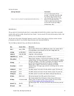
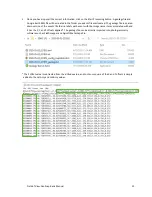
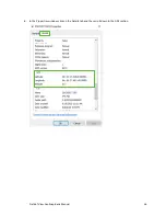
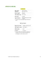
GPStow[s]
494455.391180
GPS time of week, in seconds.
TDOP
0.529
Time dilution of precision
HDOP
0.621
Horizontal dilution of precision
VDOP
0.818
Vertical dilution of precision
Alt[MSL-m]
285.289
Altitude above standard sea level, in meters
COG[deg]
315.022
Course over ground, in degrees.
VHoriz[m/s]
00.013
Velocity horizontal, in meters/second.
Vup[m/s]
00.023
Velocity up, in meters/second.
T_Etime[s]
0.045
The amount of time in seconds elapsed between the GeoSnap sending
a trigger command and receiving capture confirmation back from the
camera.
AgeDiff[s]
6
Age of differential, in seconds.
FixStatus
3D>3
NO, 3D>3,3D, and UNKNOWN
SatsInView
23
Number of satellites that are directly in view of the antenna (note: this
number will typically be higher than the number found for SatsUsed)
SatsUsed
12
Number of satellites used to determine the coordinates found in the
events file
CONFIGURATION FILE SNAPSHOT
The yyyy-mm-dd_hhmmss_config_snapshot.html file is an HTML file that contains the parameters used for the
session. While the original CONFIG file is in the root directory and is used to change GeoSnap settings, the CONFIG
file snapshot cannot be changed and is found in every session folder that gets generated. Note that an internet
connection is not required to view the CONFIG file snapshot.
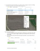
GEOTAGS TOOL
The Geotags Tool is a simple application that gets written to every session folder. It has three main functions:
1.
It creates a Pix4D and Agisoft compatible
“geotags file”
using the position data from the events file and
the image name/numbering scheme you specify.
2.
It creates a KML file that allows you to quickly see your geotags in 3D using Google Earth.
3.
It can embed geotags and their accuracy estimates into the metadata (Exif and XMP) of your images.
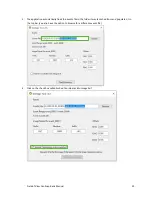
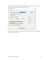
The following are two different step-by-step guides on how to use the Geotags Tool. The first focuses on how to
create the geotags file and KML file only, while the second focuses on how to also embed coordinates into the
metadata of your images. A video of the process can also be found at
https://www.youtube.com/watch?v=I9JPxTwCBio


