background image

English

Owner’

s

Manual

NP401     13    

4YPE

%XAMPLE

$ESCRIPTION

How to use it

Switch


When there are only two 
choices, a checkmark shows 
whether the feature is enabled.

Tap it to turn the switch on or off.

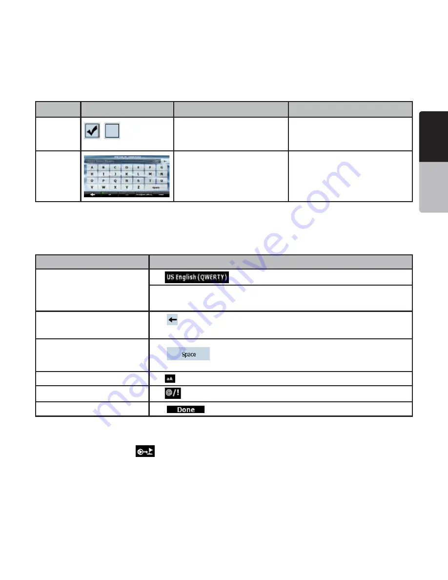
Virtual 
keyboard

Alphabetic and alphanumeric 
keyboards to enter text and 
numbers.

Each key is a touch screen 
button.

5SINGKEYBOARDS

You only need to enter letters or numbers in Clarion Mobile Map when you cannot avoid it. You can type 
with your fingertips on the full-screen keyboards and you can switch between various keyboard layouts, for 
example ABC, QWERTY, or numerical.

Task

Details

Switching to another keyboard 

layout, for example from an English 

QWERTY keyboard to a Greek 

keyboard

Tap 

, and select from the list of available keyboard types.

Clarion Mobile Map remembers your last keyboard choice and offers it the next time 

you need to enter data.

Correcting your entry on the 

keyboard

Tap 

 to remove the unneeded character(s).

Tap and hold

 the button to delete the entire input string.

Entering a space, for example 

between a first name and a family 

name or in multi-word street names

Tap 

.

Entering lowercase or capital letters

Tap 

 to cycle through entering lowercase letters, initial capitals or all capitals.

Entering symbols

Tap 

 to switch to a keyboard offering symbol characters.

Finalising the keyboard entry

Tap 

.

5SINGTHEMAP

The map screen is the most frequently used screen of Clarion Mobile Map. It can be accessed from the 
Navigation menu by tapping 

.

Summary of Contents for NP401

Page 1: ...s manual Installation manual Mode d emploi et manuel d installation Manual de instrucciones y de instalación FLASH MEMORY NAVIGATION SYSTEM SISTEMA DE NAVEGACIÓN MEMORIA FLASH SYSTÈME DE NAVIGATION À MÉMOIRE FLASH ...

Page 2: ...hotocopying and recording without the express written consent of Clarion 2010 Clarion Data Source 2006 Tele Atlas N V All rights reserved CLARION PRODUCT REGISTRATION INFORMATION For USA and Canada only www clarion com Dear Customer Congratulations on your purchase of a Clarion mobile electronic product We are confident that you ll enjoy your Clarion experience There are many benefits to registering...

Page 3: ...ACCIDENT OR TRAFlC OFFENSE REMEMBER THAT ACTUAL ROAD CONDITIONS AND TRAFlC REGULATIONS TAKE precedence over the information contained on the navigation system s4HE SOFTWARE MAY CONTAIN INACCURATE OR INCOMPLETE INFORMATION DUE TO THE PASSAGE OF TIME CHANGING CIRCUMSTANCES AND the sources of information used Please respect current traffic conditions and regulations at all times while driving s7HERE A...

Page 4: ...HIS SYSTEM with the engine of the vehicle running as much as possible s 4HE HOUSING OF THIS UNIT MAY BECOME HOT BECAUSE THIS UNIT has a high speed CPU Be careful to handle the unit during navigating or immediately after turning the power off s 4URN OFF THE POWER OF THE VEHICLE WHEN CONNECTING OR disconnecting wires Doing this while the power of the vehicle is turned on may cause a trouble or malfu...

Page 5: ...leaner etc as these substances may damage the cabinet or cause the paint to peel Also leaving rubber or plastic products in contact with the cabinet for long periods of time may cause stains s ATA SAVED TO THE mASH MEMORY MAY get lost in case of a breakdown malfunction or other trouble of this unit s PERATION OF THE NAVIGATION SYSTEM MAY BE LIMITED TO protect the unit if the temperature is extreme...

Page 6: ...ion 24 4 4 6 Itinerary 24 4 4 7 Track Logs 25 4 4 8 Route demonstration 25 4 4 9 POI Points of Interest 25 4 4 10 Road Safety Cameras 26 4 4 11 Speed limit warning 28 5 Navigating with Clarion Mobile Map 29 5 1 Selecting the destination of a route 29 5 1 1 Selecting the Cursor as the destination 29 5 1 2 Entering an address or part of an address 29 5 1 3 Selecting the destination from your Favorit...

Page 7: ... 8 Quick menu 55 6 1 9 GPS Data screen 57 6 2 Find menu 58 6 3 Route menu 58 6 4 Manage menu 59 6 4 1 Manage Saved Routes 60 6 4 2 Manage History 60 6 4 3 Manage Track Logs 60 6 4 4 Manage Favorites 61 6 4 5 Manage POIs 61 6 4 6 Manage Saved Search Criteria 62 6 4 7 User Data Management 62 6 5 Settings menu 63 6 5 1 Map Screen settings 64 6 5 2 Sound settings 65 6 5 3 Route Planning options 65 6 5...

Page 8: ...ething in the route Clarion Mobile Map has a Safety Mode if you turn on Safety Mode you cannot change anything in Clarion OBILE AP WHILE THE VEHICLE IS MOVING AT A SPEED OF KM H MPH OR HIGHER 5NLESS ONLY PASSENGERS operate Clarion Mobile Map we strongly encourage you to turn on Safety Mode You must obey the traffic signs and follow the road geometry If you deviate from the route that Clarion Mobile...

Page 9: ... set the minimum and maximum zoom level of Smart Zoom s 4AP AND HOLD ANY OF THE buttons on the Map screen you can set or reset the zoom value of the button 2D map s 4AP AND HOLD ANY OF THE buttons on the Map screen you can set or reset the tilt and zoom values of the button 3D map s 4AP AND HOLD on list and menu screens the Navigation menu appears s 4AP AND HOLD ANY OF THE and buttons on the Map s...

Page 10: ...The Navigation menu in Advanced mode The typical way of using Clarion Mobile Map is to select a destination and start navigating You can select your destination in the following ways not all of them are available in s 5SE THE SELECTED LOCATION ON THE MAP THE URSOR PAGE s NTER A FULL ADDRESS OR A PART OF AN ADDRESS FOR EXAMPLE A STREET NAME WITHOUT A HOUSE NUMBER OR THE names of two intersecting st...

Page 11: ...ailable in each mode are as follows Type of action Available in Simple mode Available in Advanced mode Explanation Navigating to a selected map point Yes Yes See page 29 Navigating to a street address Yes Yes See page 30 Navigating to an incomplete address Yes Yes See page 32 Navigating to an intersection Yes Yes See page 32 Navigating to recent destinations History Yes Yes See page 36 Navigating ...

Page 12: ... perform a major reconfiguration or you are about to lose some of your data or settings Otherwise Clarion Mobile Map saves your selections and applies the new settings without confirmation as soon as you use the controls 4YPE XAMPLE ESCRIPTION How to use it Button Tap it to initiate a function to open a new screen or to set a parameter Tap it once Icon Shows status information Some icons also functi...

Page 13: ...mple from an English QWERTY keyboard to a Greek keyboard Tap and select from the list of available keyboard types Clarion Mobile Map remembers your last keyboard choice and offers it the next time you need to enter data Correcting your entry on the keyboard Tap to remove the unneeded character s Tap and hold the button to delete the entire input string Entering a space for example between a first n...

Page 14: ... open the map control buttons 2 Tap the desired location on the map The Cursor appears there The address of the location is displayed at the bottom of the map 3 For further details tap to open the Cursor menu 4 Tap The address the coordinate and the list of nearby POIs will be displayed 5 It is even easier if you select the desired point in the Find menu Then the Cursor menu opens automatically Yo...

Page 15: ...of the map is displayed on the screen Clarion Mobile Map uses high quality vector maps that let you see the map at various zoom levels always with optimized content It always displays street names and other text with the same font size never upside down and you only see the streets and objects that you need Map scaling has different limits in 2D and in 3D map view modes Tilting up and down Changes...

Page 16: ...RION OBILE AP ZOOMS IN AND raises the view angle to let you easily recognize your maneuver at the next junction s F THE NEXT TURN IS AT A DISTANCE LARION OBILE AP ZOOMS OUT AND lowers the view angle to show you the road in front of you Tap this button once to enable Smart Zoom Tap hold the button to set the zoom limits of Smart Zoom Returning to normal navigation back to the GPS position with auto...

Page 17: ...he current voice instruction The distance is updated to always describe the current situation ANE INFORMATION AND 3IGNPOSTS When navigating on multilane roads it is important to take the appropriate lane in order to follow the recommended route If lane information is available in the map data Clarion Mobile Map displays the lanes and their directions using small arrows either at the bottom or at t...

Page 18: ...is no valid GPS position the view of the sky above you is shown with colored dots for each satellite Some dots need to turn green to be able to navigate Tap this area to open the Route Information screen If the icon is a static picture route calculation is needed GPS position and an active route are available but automatic off route recalculation is switched off and you deviated from the route Tap...

Page 19: ...ws the route event that follows the next route event shown in the above described area Tap this area to open the Itinerary screen with the turn by turn guidance instructions Approaching a Road Safety Camera This icon appears when you are approaching a Road Safety Camera and the warning for cameras is enabled in Settings Tap this area to suppress the audible camera warning Tap again to display the ...

Page 20: ...onnected to a telephone as a handsfree set via Bluetooth Blue A phone call is in progress over theBluetooth connection The following information can be seen in the three data fields shown on the map screen Tap this area to open the Trip Information screen where you can select which values to be shown in these three fields When there is no active route these fields show the following information curre...

Page 21: ...ity A higher number of lit bars indicates better GPS position accuracy Vehicle type The symbol displays the vehicle type used for route calculation 5SING THE URSOR THE SELECTED MAP LOCATION First place the Cursor at the desired map location with one of the following options s 5SE THE IND MENU TO SELECT A LOCATION 4HE MAP RETURNS WITH THE SELECTED POINT THE URSOR IN THE MIDDLE and the Cursor menu a...

Page 22: ...ad Safety Camera location available in Advanced mode only This button is not displayed when GPS position is not available or if you are in certain countries where Road Safety Camera warning is prohibited Even if the button is available you are responsible for checking whether it is legal to use this feature at your location LARION OBILE AP CONCEPTS 3MART OOM Smart Zoom provides much more than just...

Page 23: ...e the map while you are driving Clarion Mobile Map continues navigating if there is an active route it plays the voice instructions and displays the turn preview icons according to your current GPS position 3ELECTED LOCATION URSOR If you select a location in the Find menu or you tap the map the Cursor appears at the selected point on the map Clarion Mobile Map displays the Cursor with a radiating ...

Page 24: ...TION Clarion Mobile Map calculates the route based on your preferences s 2OUTE CALCULATION METHOD 1 Fast 2 Short 3 Economical 4 Easy s 6EHICLE TYPES 1 Car 2 Taxi 3 Bus 4 Emergency vehicles s 2OAD TYPES 1 Unpaved Roads 2 Permit Needed 3 Freeways 4 Toll Roads 5 Charge Roads 6 Ferries 7 Cross border Planning 8 Carpool appears only when used in the USA Clarion Mobile Map automatically recalculates the...

Page 25: ...the GPS device These logs are saved as separate text files on the memory card and they cannot be shown or replayed in Clarion Mobile Map 4O TURN ON 3 2 LOG SAVING TAP THE FOLLOWING buttons 2OUTE DEMONSTRATION A simulation drives you through the route following the driving instructions page 29 You can choose from a simulation at high speed or at normal driving speed You can use it for example to see...

Page 26: ...ext file Yes Can you save the Cursor as the location of a Road Safety Camera Yes 3AVING 2OAD 3AFETY AMERAS To save the location of a Road Safety Camera place the Cursor at the desired location then tap the following buttons Note This button is not displayed when GPS position is not available or if you are in certain countries where Road Safety Camera warning is prohibited Even if the button is avai...

Page 27: ...d cameras Section control These speed cameras work in pairs and do not measure your current speed but your average speed between the two speed cameras Both identify your car and record the exact time you pass them They use the difference between the two points in time to calculate your average speed Clarion Mobile Map warns you when you approach one of these speed cameras but as you pass by the wa...

Page 28: ...amera checks speed in the direction into which you are driving The camera checks speed in the opposite driving direction The camera checks speed in both directions on the road The camera can check speed in any direction 3PEED LIMIT WARNING Maps sometimes contain information about the speed limits of the road segments This information may not be available for your region ask your local dealer or ma...

Page 29: ...es might be faster as well s 5SE A COORDINATE PAGE s 5SE A SAVED LOCATION 1 a Favorite page 35 2 a POI page 35 3 the History of previously set destinations and waypoints page 36 Tip If you are going to use a route later save it before you start navigating Tap the following buttons 3ELECTING THE URSOR AS THE DESTINATION 1 Locate your destination on the map move and scale the map as needed page 14 2...

Page 30: ...it is in 3 If needed change the city s 4O SELECT THE CITY FROM THE LIST OF RECENTLY USED ones tap the button s 4O ENTER A NEW CITY 1 Tap the button with the name of the city or IF YOU HAVE CHANGED THE COUNTRY STATE TAP 2 Start entering the city name on the keyboard 3 Get to the list of search results s FTER ENTERING A COUPLE OF CHARACTERS THE names that match the string appear in a list s 4AP to o...

Page 31: ...O ENTER A NEW CITY 1 Tap the button with the name of the city or IF YOU HAVE CHANGED THE COUNTRY STATE TAP 2 Start entering the city name on the keyboard 3 Get to the list of search results s FTER ENTERING A COUPLE OF CHARACTERS THE names that match the string appear in a list s 4AP to open the list of results before it appears automatically 4 Select the city from the list 4 Enter the street name ...

Page 32: ...OF CHARACTERS THE names that match the string appear in a list s 4AP to open the list of results before it appears automatically d Select the city from the list 4 Enter the street name a Tap b Start entering the street name on the keyboard c Get to the list of results s FTER ENTERING A COUPLE OF CHARACTERS THE names that match the string appear in a list s 4AP to open the list of results before it...

Page 33: ...r list appears immediately b In case of a longer street a keyboard screen appears Start entering the name of the intersecting street on the keyboard As you type if the matching streets can be shown on one screen their list appears automatically 6 Tap the desired intersecting street in the list 7 The map appears with the selected point in the middle Tap Simple mode or Advanced mode from the Cursor ...

Page 34: ... YOU ARE F NEEDED TAP THE BUTTON WITH THE NAME OF THE COUNTRY state and select a different one from the list 3 Tap the button with the name of the city and enter the ZIP code a Start entering the ZIP code on the keyboard b Get to the list of results s FTER ENTERING A COUPLE OF NUMBERS MATCHING results appear in a list s 4ap to open the list of results before it appears automatically c Pick the cit...

Page 35: ...tricts of a city 3ELECTING THE DESTINATION FROM YOUR AVORITES You can select a location that you have already saved as a Favorite to be your destination The procedure is explained starting from the Navigation menu 1 Tap the following buttons Simple mode or Advanced mode 2 Tap the Favorite that you want to set as your destination 3 The map appears with the selected point in the middle Tap Simple mo...

Page 36: ...long the active route 5 Tap the desired POI in the list 6 Review the details of the selected item and tap 7 The map appears with the selected point in the middle Tap Simple mode or Advanced mode from the Cursor menu The route is then automatically calculated and you can start navigating 3ELECTING THE DESTINATION WITH SAVED 0 SEARCH CRITERIA POI search criteria can be saved in the POI section of th...

Page 37: ...and you can start navigating REATING A MULTI POINT ROUTE INSERTING A VIA POINT Multi point routes are created from simple routes so a route must be active first One of the ways of expanding the route is to keep the destination and to add via points intermediate destinations This feature is available in Advanced mode only 1 Select a new location as you did in the previous sections This will be the a...

Page 38: ...ING A MULTI POINT ROUTE APPENDING A NEW DESTINATION destination Multi point routes are created from simple routes so a route must be active first One of the ways of expanding the route is to add a new destination The previous destination becomes the last via point of the route This feature is available in Advanced mode only 1 Select a new location as you did in the previous sections This will be th...

Page 39: ...m the Map screen 1 Tap the following buttons 2 The Route menu appears There are two ways of running the route simulation s 4AP to run the simulation at high speed to give you a quick overview of the route s 4AP to run the simulation at normal speed and with voice guidance instructions announced This option is for demonstration purposes or for checking difficult parts of the route in advance 3 The s...

Page 40: ...k how your GPS position changed that you drive Tip You do not need to select a destination and create a route for this you can also record your driving path while cruising This feature is available in Advanced mode only The procedure is explained starting from the Map screen 2ECORDING THE TRAVELED PATH CREATING A 4RACK OG 1 Start driving 2 Tap the following buttons 3 Start the recording tap the bu...

Page 41: ...gation Clarion Mobile Map deletes any via points that you already left behind together with the road segments used to reach it OADING A SAVED ROUTE This feature is available in Advanced mode only The procedure is explained starting from the Map screen 1 Tap the following buttons 2 Tap the route you wish to navigate 3 In the very likely case when the start position of the saved route is different f...

Page 42: ...eting it or parts of it or planning a route without GPS reception Manage Managing user data such as saved locations POIs Favorites Pins and History items Saved Routes and Track Logs Settings Managing the behavior of Clarion Mobile Map for example the map layout during navigation the used languages or the warnings Bluetooth This button opens the phone application You can pair your Clarion NP401 wit...

Page 43: ... data Opens the Trip Information screen GPS position quality Opens the Quick menu Vehicle used in route calculation Opens the Quick menu Top row Next street or Next city Additional buttons and controls appear for a few seconds Bottom row Current street and house numbers on left and right Additional buttons and controls appear for a few seconds Map view modes Switches between 2D and 3D map modes s ...

Page 44: ...T AND ZOOM PRESET BUTTONS MAP ONLY s 2ETURN TO 03 POSITION BUTTON s 3MART OOM BUTTON Rotate left rotate right Rotates the 3D map left or right Tilt up tilt down Tilts the 3D map Zoom in zoom out Scales the map Return to GPS position appears when GPS position is available and you have moved the map Tap this button to move the map back to the current GPS position If the map has been rotated automati...

Page 45: ... its value to the current tilt and zoom levels or to reset it to its original value Current GPS position on nearest road N A Cursor selected map location N A Lane information N A Signpost information N A Blue line Active route N A Map scale 2D map only N A Speed limit N A Phone call in progress This button is displayed only during a phone call Tap the button to hang up Repeat Voice Instruction Tap...

Page 46: ...ant Altitude information is available the position is a 3D position GPS navigation is possible The remaining part of the field shows the vehicle type used for route calculation CON 6EHICLE TYPE Car Taxi Bus Emergency vehicles 3TATUS INDICATOR STRIP This is a multiple status indicator It indicates the following status information on a single strip 0HONE CALL IN PROGRESS When connected to a cell pho...

Page 47: ...n in the circle but only for the next turn Enter freeway Exit freeway CON ESCRIPTION Board ferry Leave ferry Approaching the next via point Approaching the destination In certain situations when route events are not important these fields show other useful pieces of information They are described here page 38 BJECTS ON THE MAP 3TREETS AND ROADS Clarion Mobile Map shows the streets in a way that is ...

Page 48: ...t position displayed on the map If roads are near it is aligned to the nearest road Cursor selected map location The location selected in the Find menu or a map point selected by tapping the map Via point A via point is an intermediate destination You can place as many via points as you want Destination end point The last point of the route the final destination Route color The route always stands ...

Page 49: ...and the Cursor menu opens with a list of options You can perform the following actions in Simple mode Symbol Name Description Streets and roads that are excluded from the navigation You can choose whether you want to use or avoid certain road types page 65 However when Clarion Mobile Map cannot avoid such roads the route will include them and it will show them in a color that is different from the...

Page 50: ...e list of nearby POIs The following options are available in Advanced mode only UTTON ESCRIPTION Creates a new route with the Cursor as the destination The previous route if exists is deleted If the Cursor is at or near the destination this button replaces the previous one and deletes the current destination from the route The last via point is promoted as destination or if there are no via points...

Page 51: ...route Recalculation is re enabled UTTON ESCRIPTION The Cursor is saved as a user POI Select the POI group and give a name for the POI then select a suitable icon enter a phone number and additional information if you like The Cursor is saved as the location of a Road Safety Camera speed camera or red light camera A new screen appears where you can set the type of the camera the direction of the me...

Page 52: ... VIA POINT mAGS ALONG THE LINE SPACED IN PROPORTION TO THEIR distance Tap this field to change the content of all data fields to via point information Estimated Arrival Shows the estimated arrival time at the final destination of the route based on information available for the remaining segments of the route The calculation cannot take into account traffic jams and other possible delays Tap this field...

Page 53: ... fields show information about the final destination checkered mAG OR ABOUT THE NEXT VIA POINT YELLOW mAG Field next to THE mAG Shows the name or number of the current street or road Turn Preview Shows the type and distance of the next route event Name Description Function Warning icons In these square fields graphical symbols are displayed in case warnings are attached to the planned route These are...

Page 54: ...ormation available for the remaining segments of the route The calculation cannot take into account traffic jams and other possible delays Tap this field to show it on the map screen in one of the Trip Data fields GPS Time Shows the current time corrected with time zone offset The accurate time comes from the GPS satellites and the time zone information comes from the map or it can be set manually in...

Page 55: ...creen open You can switch between the trips pause then resume them or reset their data You have the following functions on this screen UTTON ESCRIPTION Cycles through all trips Pauses the trip currently shown on the screen Values on the screen stop changing This button replaces the previous one if it has been activated Tap it to resume collecting trip data Resets all counters of the currently show...

Page 56: ...s switch to suppress them temporarily Please note that 3D landmarks are displayed regardless of this button wherever they are available Opens 3D Settings Tap this button and select the Vehicle type to be used for route calculation Otherwise it is selected in Route Planning options in Settings page 64 Changing the Vehicle type triggers an automatic route recalculation Opens Route Planning options T...

Page 57: ...y the horizontal position is calculated Clarion Mobile Map cannot calculate your vertical GPS position Gray Clarion Mobile Map has a connection to the GPS receiver but GPS position information is not available Red Clarion Mobile Map has no connection to the GPS receiver Since the device has a built in GPS receiver this status should not appear under normal circumstances Green blinking GPS connecti...

Page 58: ...ted position IND MENU Select the destination of your route Tap the following buttons UTTON ESCRIPTION 2EFERENCE If you know at least a part of the address this is the quickest way to find the location page 29 You can select your destination from the thousands of POIs included with Clarion Mobile Map or from the ones you have previously created page 35 The destinations that you have already entered ...

Page 59: ...can load a previously saved route for navigation page 41 Opens the Route settings screen with controls to modify the vehicle the road types used for route calculation or the route calculation method page 66 You can run a demonstration of the route at high speed page 39 You can run a demonstration of the route at normal speed page 39 6 4 Manage menu You can manage the content that Clarion Mobile Ma...

Page 60: ... in the History Deletes the entire History Moves between pages for additional list items ANAGE 4RACK OGS You can record Track Logs then play them back display them on the map and view their details Tap the following buttons Button Description Starts recording the track that you drive You can also start recording a track log in the Quick menu Stops the ongoing Track Log recording You can also stop ...

Page 61: ...for both your POIs and the ones that came with the product Tap the following buttons UTTON CON Description Button with the name of the POI group Opens the list of the subgroups of this POI group The new list behaves the same as this one Button with the name and address of a POI item Opens the selected POI for editing Only the POIs you have created appear in this list Opens the selected POI group f...

Page 62: ...cate the POI Tap this button to enter a telephone number for the POI Button Description Tap this button to enter additional information for the POI Tap this button to delete the selected POI Tap this button to move the POI to another POI group or subgroup ANAGE 3AVED 3EARCH RITERIA You can manage the list of search criteria previously saved to easily find frequently searched POI types Tap the follo...

Page 63: ...cation needs to restart All settings will return to their factory defaults but no user data will be deleted The application needs to restart 6 5 Settings menu You can configure the program settings and modify the behavior of Clarion Mobile Map Tap the following buttons The Settings menu has two pages of submenus Tap to access the other options Button Description Reference You can fine tune the appea...

Page 64: ...etermine which of the present 3D objects are shown on the map and adjust the level of 3D visual detail The options are as follows s ANDMARKS ANDMARKS ARE ARTISTIC OR BLOCK REPRESENTATIONS OF PROMINENT OR WELL known objects 3D landmarks are only available in selected cities and countries s LEVATED 2OADS OMPLEX INTERSECTIONS AND VERTICALLY ISOLATED ROADS SUCH AS OVERPASSES or underground tunnels are...

Page 65: ... a maneuver 3OUND SETTINGS You can adjust the sounds of Clarion Mobile Map Tap the following buttons Button Description Master Volume Use the switch to mute all sounds of the device and then to re enable them again The position of the slider determines the volume level Voice Guidance Volume The slider adjusts the loudness of voice prompts In its leftmost position the voice guidance is suppressed i...

Page 66: ... method can be changed temporarily while creating the route when the destination is selected tap in the Cursor menu 2OAD 4YPES 5SED FOR 2OUTE 0LANNING Type Description Freeways You might need to avoid freeways when you are driving a slow car or you are towing another vehicle Unpaved roads Clarion Mobile Map excludes unpaved roads by default unpaved roads can be in a bad condition and usually you c...

Page 67: ... option you can make Clarion Mobile Map to take for example the freeway instead of series of smaller roads or streets 2EGIONAL SETTINGS These settings allow you to customize the application for your local language measurement units time and date settings and formats as well as to choose the voice guidance profile you prefer Tap the following buttons Button Description Program Language This button d...

Page 68: ... to synchronize the time zone automatically This allows you to use Auto Time Correction and apply a time zone offset to obtain the desired time Compare GPS and device times The current time of the GPS receiver and the device clock are displayed Please note that the GPS clock is only available with GPS reception This allows you to check whether any correction is needed AVIGATION SETTINGS You can co...

Page 69: ... Automatic Overview This feature switches the map view to Overview mode when the next route event is at a distance Overview is a zoomed out 2D view to let you see the surrounding area You have the following controls for Automatic Overview s 4URN ISTANCE FOR VERVIEW 4HE MAP VIEW WILL BE SWITCHED TO VERVIEW MODE IF THE next route event is at least as far as this value s EFAULT OOM EVEL VERVIEW MODE ...

Page 70: ...ed Camera Warning This feature allows you to receive awarning when approaching a Road Safety Camera You must ensure on your own liability that using this feature is legal in the country where you intend to use it You have the following options s UDIBLE 7ARNING BEEPS CANBE PLAYED WHILE YOUARE APPROACHING THE CAMERA OR JUST ALERT sounds if you exceed the speed limit while approaching one of these ca...

Page 71: ...ed once a second from the GPS If you do not need such a detailed log you can increase this number to save track log space Enable Auto saving When auto saving is enabled you do not need to turn track log saving on and off manually Clarion Mobile Map will automatically start recording the track log as soon as GPS position is available Track Log Database Size This figure shows how much memory is used ...

Page 72: ...or reflecting objects near the GPS device have a different and varying impact on how accurately the GPS device can calculate your position AP Clarion Mobile Map works with digital maps which are not simply the computerized versions of traditional paper maps Similarly to the paper road maps the 2D mode of digital maps show you streets roads and elevation is also shown by colors In 3D mode you can s...

Page 73: ...e responsibility of the driver to check whether this feature can be used during the trip 8 End User License Agreement 4HE CONTRACTING PARTIES 1 1 This Agreement has been entered into by AND BETWEEN AV O FT REGISTERED SEAT Bérc utca H 1016 Budapest Hungary Company reg no 01 09 891938 as Licensor hereinafter Licensor and You as the User hereinafter User the User and the Licensor jointly referred to ...

Page 74: ...s are the natural person s or corporate entity ies listed in the Appendix to this Agreement or in the About menu item of the operating computer program hereinafter referred to as Database Owner The user s manual of the Software Product includes the name of the menu option where all the owners of the Database items are listed The Licensor hereby states that it has obtained sufficient usage and repr...

Page 75: ...ON OF RESPONSIBILITY 8 1 The Licensor hereby informs the User that although the greatest care was taken in producing the Software Product given the nature of the Software Product and its technical limitations the Licensor does not provide a warranty for the Software Product being completely error free and the Licensor is not bound by any contractual obligation whereby the Software Product obtained...

Page 76: ...y liability of its own for the Database in the Software Product and for any content or service provided by a third party by using the Database The Licensor does not warrant the quality suitability accuracy fitness for a specific purpose or territorial coverage of the product or service or the availability of the service and it specifically excludes any liability for the suspension of the service and ...

Page 77: ...onsult your store of purchase Incorrect wiring Consult your store of purchase Nothing happens when buttons are pressed Display is not accurate The microprocessor has malfunctioned due to noise etc Turn off the power and open the operation panel Press the reset button with a thin rod Note When the Reset button is pressed turn off the ACC power When the Reset button is pressed stored in memory are c...

Page 78: ...AND DESIGN ARE SUBJECT TO CHANGE without notice for further improvement 11 Installation Wire connection guide EFORE 3TARTING 1 This set is exclusively for use in cars with a negative ground 12V power supply 2 Read these instructions carefully 3 Be sure to disconnect the battery terminal before starting This is to prevent short circuits during installation Figure 1 2 Package Contents Main Unit 1 GP...

Page 79: ...HEM WELL AWAY FROM THE ENGINE AND EXHAUST PIPE ETC EAT MAY damage the wires 3 If the fuse should blow check to see if the wiring is correct If a fuse is blown replace it with a new one of the same amperage rating as the original 6 Wire Connections Note s Before installing be sure to disconnect the negative cable of the car battery 3 General Cautions 1 Do not open the case There are no user service...

Page 80: ...English Owner s Manual 80 NP401 6 Connector Cable Antenna assembly VX401 Connector Cable Antenna Antenna assembly ...

Page 81: ...2011 01 NP401 Clarion Co Ltd All Rights Reserved Copyright LARION O TD Printed in China MPRIME AU HINÏ MPRESO EN HINA ...

Page 82: ...re de Service et Garantie 2239 Winston Park Drive Oakville Ontario L6H 5R1 905 829 4600 www clarion com uUl Clarion GARANTIE LIMITEE DE 1 AN CLARION Pour Ie Canada et les Etats Unis seulement Ce produit Clarion vendu par un marchand autorise Clarion est garanti contre tous detauts de materiel et de fabrication pour une duree d un 1 an acompter de la date de vente initiale lorsque I achat est effec...

Page 83: ...rranty Service Center 2239 Winston Park Drive Oakville Ontario L6H 5R1 905 829 4600 www c1arion com prall clarion 281 0639 01 2008 9 CLARION 1 YEAR LIMITED WARRANTY For USA and Canada only This Clarion product purchased from an authorized Clarion dealer are warranted against all defects in materials and workmanship for a period of one 1 year from the date of original purchase other than consumable...

Reviews: