


Map Page
Envision EX5000
-16-
600-00151-001 Rev 01
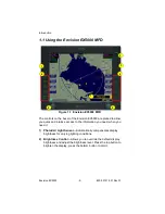
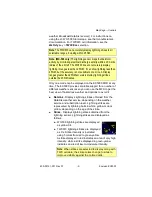
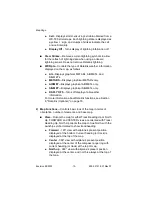
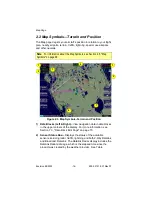
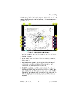
2.2 Map Symbols—Terrain and Position
The Map page depicts your aircraft’s position in relation to your flight
plan, nearby airports, terrain, traffic, lightning, special use airspace
and other navaids.
Figure 2.3 Map Symbols–Terrain and Position
1) Data Blocks (Left & Right)
—View navigation data in data blocks
in the upper corners of the display. For more information, see
Section 7.3, "Data Block Edit Page" on page 73.
2) Sensor Status Box—
Displays the status of the available
sensors including radar, traffic, lightning and both 2-Way Datalink
and Broadcast Datalink. The Datalink Radar display includes the
Datalink Radar data age, which is the elapsed time since the
product was created by the weather provider. See Table
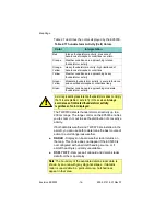
Note:
For information about the Map Symbols, see Section 9.5, "Map
Symbols" on page 99.
4
1
1
7
5
2
3
6
Summary of Contents for Envision EX5000
Page 1: ...600 00151 001 Rev 01 ...
Page 2: ......
Page 8: ...Envision EX5000 vi 600 00151 001 Rev 01 This page intentionally left blank ...
Page 18: ...Introduction Envision EX5000 6 600 00151 001 Rev 01 THIS PAGE INTENTIONALLY LEFT BLANK ...
Page 36: ...Map Page Envision EX5000 24 600 00151 001 Rev 01 ...
Page 46: ...CMax Chart Pages Optional Envision EX5000 34 600 00151 001 Rev 01 ...
Page 58: ...CMax Chart Pages Optional Envision EX5000 46 600 00151 001 Rev 01 ...
Page 73: ...600 00151 001 Rev 01 61 Envision EX5000 THIS PAGE INTENTIONALLY LEFT BLANK ...
Page 74: ...Trip Page Envision EX5000 62 600 00151 001 Rev 01 ...
Page 78: ...Nearest Page NRST Envision EX5000 66 600 00151 001 Rev 01 THIS PAGE INTENTIONALLY LEFT BLANK ...
Page 107: ...Activating Broadcast Datalink Accounts 600 00151 001 Rev 01 95 Envision EX5000 ...
Page 140: ...Envision EX5000 128 600 00151 001 Rev 01 This page intentionally left blank ...
Page 141: ......