background image

Electronic chart system

37

2-9-4 Hardware connection

Communication protocol: Please set the rate of output AIS to 38400 bits. It is

connected with the SARACOM, AIS SI-10,IO 30 feet (ground) and 31 feet (data) to

date output. If the AIS signal is no input,please reverse the polarity of feet 7,and feet

8.When properly connected, the three letters "AIS". Will be displayed

in the screen

above.

The definition of the eight core aviation plug data port IO as follows

1: 0183 output road

A + extremely

2: 0183 output road A -extremely

3: 0183 output road B + extremely

4: 0183 output road B -extremely

5: 0183 output road C + extremely

6: 0183 output road C -extremely

7: AIS input - extremely

8: AIS input + extremely

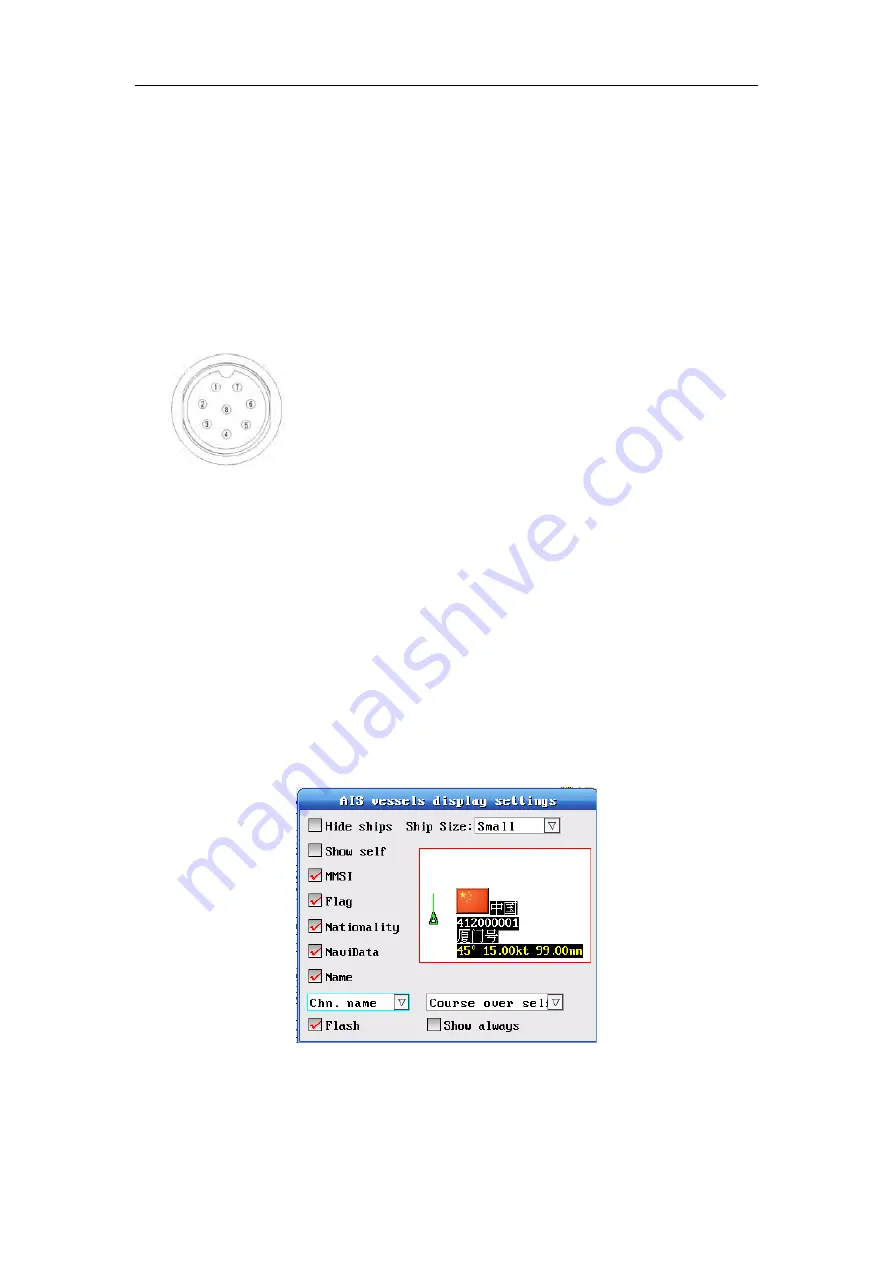
2-9-5 The AIS display settings

Please select

2:AIS display setting

to the

AIS vessels display settings

.Then you

can select and set it .

Содержание HM-5817

Страница 1: ...User s manual Including the safe use of essentials HM 5817 Electronic chart system Wal way iChart GPS satellite navigation systems 1996 2017 Xinuo Information Technology Xiamen Corporation Limited ...

Страница 2: ...and some use of operational information Warning You must read the important safety information package box manual to understand the production safety statements and other important information Disclaimer The following article mentions of the Xinuo refers to Xinuo Information Technology Xiamen Corporation Limited Note This equipment is not used for judging navigation directly Please refer to other ...

Страница 3: ... 6 Power supply should be grounded to prevent static electricity and lightning turn off the power when the instrument temporarily does not use 7 If the navigator is unable to locate a long time first check whether the antenna installation whether it is bad being blocked or whether there are other disturbances around the antenna The GPS antenna is the active antenna you must make sure the antenna c...

Страница 4: ... 1 1 The main screen data 15 2 2 Chart operating in the normal state of navigation 16 2 2 1 Mobile charts 16 2 2 2 Chart zoom in out 17 2 2 3 Adjust the brightness 17 2 2 4 Changing chart display mode 17 2 2 5 Rotation chart 17 2 2 6 View Chart 18 2 3 The main menu operation 18 2 4 Track Operations 19 2 4 1 Track switch and color 19 2 4 2 Set the methods and parameters t of recording track 19 2 4 ...

Страница 5: ...ndar 39 2 11 4 Measure the distance between two points 39 2 11 5 Material Inquires Port info 40 2 11 6 Satellite Information 41 2 12 MOB List 41 2 13 The note in the navigation 41 2 13 1 Waypoint navigation 41 2 13 2 The The planned route navigation 41 2 14 Input method menu 42 2 15 Parameter Settings 43 2 15 1 System Settings menu 43 2 15 2 Alarm Settings menu 43 2 15 3 Chart Color Settings menu ...

Страница 6: ...Electronic chart system 5 Chapter I Overview This chapter describes the appearance of products accessories and other related knowledge ...

Страница 7: ... sailing s navigator Please check various objects whether all the same with the following list in the contents of the box immediately If the quantity does not meet or damaged please contact your dealer in a timely manner Items list A host navigator u A GPS antenna u A remote control keyboard u Four fixed screw u A power line u A data line u A manual u A warranty list u A qualified certificate ...

Страница 8: ...o the Angle 1 2 1 Installation and connection This manual is suitable for HM 5817 models detailed installation in the appendix describes The whole external interface definition shown above 1 GPS ANT 2 USB 3 DATA3 4 DATA2 5 DATA1 6 KEYBOARD 7 POWER The power connector is a 2 pin socket connection The red is the positive electrode of power The black or blue is the negative electrode of power The two...

Страница 9: ...wn right 1 The power of positive electrode 2 The power of negative electrode The keyboard interface definitions as shown right 1 VCC 2 KB DATA 3 GND 4 KB CLK USB interface definitions as shown right 1 VCC 2 DATA 3 GND 4 DATA Data 1 as shown below Data 2 as shown below Data 3as shown below ...

Страница 10: ...connected It can not receive GPS signal in the room Antenna must to be installed around obstacles block on the ship The nearby obstacles may block the reception of satellite signals 1 3 Switch on the system All ready you can connect the power source open the machine open the host Power button You will see the interface welcome to use the system startup and GPS start to locate position Note it will...

Страница 11: ...ll add 1 The green part represents the value of current volume as shown below 6 Narrow Chart 7 Cancel button 8 The Arrow keys up down left right 9 Main menu button 10 Previous point In the normal state of navigation prev key is to enter into the distance function when call the route guidance it can set a previous point to navigate In the input method state it is used to switch the input methods 11...

Страница 12: ...nction key the system will save the current ship s position automatically 24 Add routes 25 Add waypoints 26 Add markers 27 Navigation quickly This function keys can call the fast navigation window This window showns all the stored waypoints and routes in the system The labeled routes or waypoint will be displayed in the front of window You can press the Help key to find the help information of spe...

Страница 13: ...rth takes 11 hours 58 minutes When all the satellites in their track We can obtain accurate positioning anywhere in the world all the day 1 5 2 Positioning principle Your position can be calculated according to the distance of the two satellite to ship We Calculate the time of ships satellite signal to get the distance 300000 miles or 186000 miles per second However The clock signal is not synchro...

Страница 14: ...ound control station monitor and control the satellite The user part GPS receiver Note The direction angle Provided by the GPS heading etc is the true north direction Use distinguish true north with the direction of the magnetic north direction The attention in use to distinguish between the real north direction and the magnetic north direction ...

Страница 15: ...c chart system 14 Chapter II The basic operation and Settings This chapter will guide you gradually familiar with using the system navigation you will grasp the system Settings and navigation operation quikly 2 ...

Страница 16: ...sed to describe the ship of signal information received by the GPS When GPS data is valid Ship s position of latitude and longitude are displayed as white lettering When GPS data is invalid Ship s position of latitude and longitude are displayed as dark red font l Cursor data display window Explanation This window is used to describe the location of the cursor which will change with the change of ...

Страница 17: ...ree or three more satellites Tip The above four windows open or closed in accordance with the following methods Double click on the remote control keyboard menu keys From the parameters set select the display switch menu Enter set the display status menu Then you can see the switches satellite signa calendar card the cursor data shown The ship data shown which Depend on you re your need to set l N...

Страница 18: ... power button on the front panel keypad 2 2 4 Changing chart display mode Press the after point to change the Chart display mode The system provides 5 kinds of Color Wheels which are normal daylight gray night for you You can choose to set according to the time or your hobby Sunny is the system automatically default mode Operation method Press the after point to call the display mode setting As sh...

Страница 19: ...e Remote keyboard In the normal state of navigation As shown below Functions The menu provides quickly access to route data and input route data Operation method Press up down to select the menu items on the Remote keyboard or input the front number of menu items to enter its submenu directly The cancel key to close the current menu The menu key to enter Parameter Settings Functions Modify the sys...

Страница 20: ...pressing the color key You can also turn on or off the track recording through the track operations The specific operation saw by the 3 4 2 section colors When change color the recording track will be to redraw the modified color 2 4 2 Set the methods and parameters t of recording track Method one Setting the way of recording select the set item in the track operations menu you will enter the set ...

Страница 21: ...ou selects the Modify track in the track menu It will enter into the Logging options of Modify track Note It sets the track of name color style track only effect for the single track through the second way However the setting of Recording time distance interval Will take effect in all tracks ...

Страница 22: ...e following methods Method one waypoint key to add Please press the Arrow keys to move the cursor on the chart to the place needed to add new waypoint Then press waypoint key It will pop up the Edit waypoint box Edit the locked state name color symbol of the waypoint Then press save That s all the waypoint can be added now Note the number of waypoints cannot be modified Second goes to Waypoint lis...

Страница 23: ...ion 2 Select it through the number keys 1 and 2 quickly is shown below Note 1 If the current input waypoint information is incomplete it will not continue 2 when the cursor is in the latitude and longitude You select cancel to lead to be zero quickly it is to abandon the current date The input data is invalid 3 When the cursor in the Name field you can only delete the text Tip in the chart mode de...

Страница 24: ...ied in the waypoint list press the ok to pop up the Waypoint operation menu Then select modify the waypoint item press ok Method three shortcuts Please press the key to enter the quickly edit mode in the waypoint list and then modifies Note You must select the navigation or Save button of the menu after editing Then press ok to save the modified values 2 5 3 Delete Waypoint l Delete the single way...

Страница 25: ...oute 3 Locked waypoints Kill select the waypoint you want to delete on the chart when there is a Checked box press the ok key in the pop up menu then select Delete waypoint to delete 2 5 4 Invoke Waypoints Method one invoke waypoint on the chart Please move the cursor select the waypoint you want to invoke Then air click in the box will Pop up on the screen At this time press the ok pop up the men...

Страница 26: ...0 markers You can add new markers through the following methods Method one marker key to add Please press the Arrow keys to move the cursor on the chart to the place needed to add new marker Then press marker key It will pop up the Edit marker box Then press save That s all the marker can be added now Second goes to Marker list to add Please select a blank in the Marker list Then Select add marker...

Страница 27: ...to lead to be zero quickly it is to abandon the current date The input data is invalid 3 When the cursor in the Name field you can only delete the text Kill If press the ok in the chart mode then select Add marker in the shortcut menu You will add it quickly 2 6 2 Modify Markers Method one modifing by selecting the marker on the chart Please move the cursor select the marker you want to modify The...

Страница 28: ...the Marker List then press the ok choose Remove Marker in the marker operation The System will pop up a message box The marker will be deleted afte pressing the ok l Delete all the markers Please select one line then press the ok in the Marker List choose delete all in the marker operation The System will pop up a confirmation warning box of clear markers The markers will be deleted afte pressing ...

Страница 29: ...peration menu It will pop up Setting beacon box Edit it then save Method two enter to Beacons list to batch add 1 Input the number of keys on the remote control you will add modify the beacon information at the cursor directly and quickly Taking a operation of waypoint symbol color previous next by the arrow keys quickly When the cursor moves to the next one It automatically saves the previous mar...

Страница 30: ... the chart Please move the cursor select the beacon you want to set Then the message box will Pop up on the screen At this time press the ok pop up the menu of beacon operation Select Setting beacon to enter into the edit box to set Second Set from the Beacon List Press the Arrow keys key to select one needed to be modified in the beacon list press the ok to pop up the beacon operation menu Then s...

Страница 31: ...t Kill select the beacon you want to delete on the chart when there is a Checked box press the ok key in the pop up menu then select Delete beacon t to delete 2 7 4 Move Beacon Press select the beacon you want to move on the chart when there is a checked box press the ok in the pop up menu then select Move beacon in the pop up beacon operation Then move the cursor to a new position and press ok 2 ...

Страница 32: ...ok to modify the route s name and the to switch between waypoint numbers and route path The flashing box says the selected waypoint You choose the waypoint on the left column then press ok It will be added to the route Please press the to choose save after editing Then press ok to be saved and exit Choose cancel is to give up the course editor and quiting 2 8 2 Modify the routes Press the Arrow ke...

Страница 33: ...s is the same as the kill1 At this time press the ok the cursor switch to the left column choose the waypoints you want to add and then press the ok Note 1 The selected waypoints must be saved if we choose waypoints not stored It can t be added to the route 2 Consecutive waypoints can t be repeated 3 The route must be contain more than or equal to two waypoints in order to be saved 2 8 3 Delete th...

Страница 34: ... navigation or reverse navigation in the route operations Method two Called by keyboard directly Press the call then pop up call navigation data At this time you can call waypoints to navigation and press the key to switch to the forward route calls or the reverse route calls on the remote control keyboard Then press the to enter number column to input the number of routes press ok to the route na...

Страница 35: ...of the ships will dynamic display on the chart form the output of AIS So you can intuitive understand the position heading speed MMSI call sign name size of the nearby ships thus it offer the reference and basis for the collision and the navigation plan 2 9 1 View the other Vessels on the chart Note 1 The response time of the Vessels position is connected with the status of the vessel the speed fa...

Страница 36: ...ystem cann t recognize the position speed heading name of vessels 2 9 2 View the AIS vessel information Please press the menu to the main menu Then select AIS vessel information press the ok to enter And select AIS vessel information As shown in figure demonstration The date that all of the ship identifid will displayed in data bar At this time You can use the arrow keys to move up and down to vie...

Страница 37: ...ollowing corresponding head date Distance the distance between the ship and the target ship the distance unit is nautical mile Directions from the position of the target ship to the self ship Length The length of the self vessel Width The width of the self vessel 2 9 3 View the information of Vessel on the chart Please move the cursor to the position of the ship the information of ship will be dis...

Страница 38: ...rly connected the three letters AIS Will be displayed in the screen above The definition of the eight core aviation plug data port IO as follows 1 0183 output road A extremely 2 0183 output road A extremely 3 0183 output road B extremely 4 0183 output road B extremely 5 0183 output road C extremely 6 0183 output road C extremely 7 AIS input extremely 8 AIS input extremely 2 9 5 The AIS display set...

Страница 39: ...d 200 years Methods 1 Press the tide on the remote control keyboard call up the tide menu 2 main menu accessory accessory tide Operation method Press toSwitch to select the region and tide stations Press toSwitch to view the tide of the previous day and the next day at the same place and time Press toSwitch to view the tide of the first day of last month at the same place and time Press cancel to ...

Страница 40: ...s and 10 major lunar festivals every year Methods 1 Press the calendar on the remote control keyboard call up the calendar menu 2 main menu accessory accessory calendar Operation method Please press to view the calendar of of the previous year and the next year at the same month press to view the calendar of of the previous month and the next month at the same year press the to view the today s ca...

Страница 41: ...aypoint to reset a previous waypoint on the planned route 2 11 5 Material Inquires Port info Functions The menu offers to inquire the port information about 58 ports in the country It includes a variety of information about port s geographical location geographical structure tides navigation marks impaired airlines things sailing tips It will be to let you know the port during the voyage Methods 1...

Страница 42: ... Way point list The number of the mob is form 5000 to5019 You can also view modify call the mob 2 13 The note in the navigation 2 13 1 Waypoint navigation If you call up a waypoint to navigation It will draw a arrival alarm ring near the waypoint The value of alarm ring is setted in the Alarm settings When the boat Sails into the alarm ring and the alarm switch is opened The system will ring autom...

Страница 43: ...e will take a tip at the top right of the input method window The chinese model provides selection of words English capital lowercase and digital only have the tip Letters input method Please put the input mode switch to English letters either uppercase or lowercase mode if you want to input A you simply press the numeric keys 2 once if you want to input B you continuous press the numeric keys 2 t...

Страница 44: ...e After pressing to select the parameter svalues to modify the satellite signal filtering and system time difference You need to press ok to set up successfully Otherwise the setting has no effect 2 15 2 Alarm Settings menu Function Set the alarm switch and the alarm range Call Method parameters setting Alarm Settings Then press ok Operation method Please press to select the alarm parameters you n...

Страница 45: ...alarm 2 15 3 Chart Color Settings menu Function It provides the function about matching colors for the the land boundary water depth etc Their colors matched by the red green and blue color Call Method parameters setting Chart Color Chart Color Setting press ok to chose one Custom colors select ok and save Operation method Please press to select the chart color you need to set in the Chart Color S...

Страница 46: ...e informationtable Include cursor Satellite table calendar etc Call Method parameters setting Display switch Display switch Setting press ok to set Operation method press to select one you need to set Press to set the dispiay value Then press the Cancel will Pop up the To save setting After all the setup is complete Select Yes to save the all setting Select No to cancel the all setting As shown be...

Страница 47: ...iay value Then press the Cancel will Pop up the To save setting After all the setup is complete Select Yes to save the all setting Select No to cancel the all setting Kill P ress the brightness on the remote keyboard or power on the panel power can also adjust the brightness of the screen Press the volume on the panel can also adjust the volume on the panel 2 15 6 Signal check menu Functions View ...

Страница 48: ...method the Parameters setting view hardware information 2 15 8 GPS channal settings menu Function Setting the GPS signal channel Call method Parameters setting GPS channal settings 2 15 9 Versions menu Functions View the version of the procedure and the date and scope of the charts Call Methods Parameter Settings Parameter Settings 8 Version ...

Страница 49: ...Electronic chart system 48 Appendix Appendix 1 HM 5817 Installation dimension Units mm As shown below ...

Страница 50: ...Electronic chart system 49 Appendix 2 Installation drawings ...

Страница 51: ...ed installation There are four manhole covers in the front part of the 5817 whole machine 1 Four embedded holes in the Manhole covers as shown in the following chart Note The whole installation with different directions pay attention to the asymmetry of the holes ...

Страница 52: ...ording to the direction of the arrow 3 up to open the manhole cover to broke out of cover by a certain slope 4 Put the machine into the embedded slot 5 Screw were screwed into the four holes fixed 6 The holes cove with lid the machine ...

Страница 53: ... the USB cover in the 2 Open the USB cover side front of the whole machine by counterclockwise 3 Insert the U disk to upgrade operation in the USB upgrade mouth 4 Boot the automatically upgrade operating will be displayed on the screen 5 The upgrade is complete shut down Remove the upgrade tool ...

Страница 54: ...Electronic chart system 53 Appendix 6 Fix installation drawings and adjust the installation perspective ...

Страница 55: ...mation Technology Xiamen Corporation Limited Address No 17 701 Wanghai Road Software Park 2nd Phase Xiamen China Tel 0592 3300300 Fax 0592 3300310 Http www xinuo com E mail info xinuo com Service call 400 8868 592 ...

Отзывы: