background image

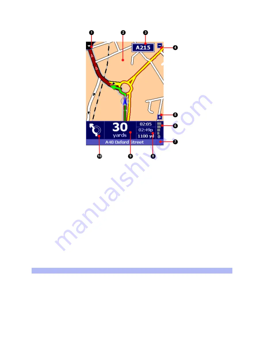
(1) View selector, (2) Map display, (3) Freeway indicator,

(4) Zoom-out button, (5) Zoom-in button,

(6) GPS signal indicator,

(7) Current location indicator, (8) Trip information,

(9) Distance to next instruction, (10) Next instruction symbol

The Navigator view provides driving instructions using a combination of text, symbols, voice guidance
and a moving map. The map shows your automobile and its immediate surroundings, rotated in such a
way that the direction in which you are moving is always "up". The route that TomTom Navigator
recommends is emphasized in dark red.

At the bottom of the screen is the dark-blue Navigator status bar. It shows what you should do next
(10), the distance you still need to travel before you do it (9), and three estimates (8) concerning your
trip: how long before you reach your destination, how late you will arrive there, and the distance to
your destination.
It also shows the signal strength of your GPS receiver (6) and your current location (7).

Things you can do in this view

Switch to another view

First of all, you can switch to another view using the pull-down menu in the top left corner (1).
Incidentally, this also causes the default Pocket PC title bar to re-appear, allowing you to switch to
other applications.

Zoom in or out

Содержание Navigator Navigator 2

Страница 1: ...refman ref_usa html 02 25 2004 06 25 53 PM TomTom Navigator 2 24 2 Reference Manual loin of Contents 1 The Navigator View 2 The Map View 3 The Favorites view 4 The Properties 5 The GPS Status 6 Pocket Outlook 7 The London Congestion Charge 8 Contacting TomTom 1 The Navigator View ...

Страница 2: ...ends is emphasized in dark red At the bottom of the screen is the dark blue Navigator status bar It shows what you should do next 10 the distance you still need to travel before you do it 9 and three estimates 8 concerning your trip how long before you reach your destination how late you will arrive there and the distance to your destination It also shows the signal strength of your GPS receiver 6...

Страница 3: ...e first wizard screen asks for the name of the city the next for a street or key location and the last for a house number or intersecting street Note On the third page crossings marked with an asterisk can not be reached by automobile Crossings marked with a dash can be reached by automobile but the crossing road itself can not Favorite Displays your list of favorite locations which you ve made us...

Страница 4: ...retch of freeway Note The new route may still use another stretch of the E35 to get you to your destination Original route Discards all the road blocks avoided areas and alternatives you have introduced and calculates the quickest route from your current location to your destination Turn 3D View ON Turns on the three dimensional display of the map Use Night Colors Displays the map in colors that p...

Страница 5: ...ls Turn Guidance OFF Turns of the spoken and symbolic instructions and hides the display of the planned route Memorize position Adds your current location to the list of recent locations Later you can set it as a favorite or Point of interest and set is as a destination GPS Status Shows the GPS management application offering detailed information about your GPS receiver and its measurements and al...

Страница 6: ...rivers and such The menu option legend see below provides a lot of information about what is displayed On top of that you may also encounter the following special symbols on the map Your departure location The current destination One of your favorite locations The Home location A Point of interest POI In this particular case a gas station The cursor Your current location and direction if and when ...

Страница 7: ... to influence the number of roads and names displayed at the same time on the current map Tap the icon again to hide the controls Tap and hold options for a particular location When you Tap and hold your pen on a location on the map you will be presented with a choice of options Which options are presented depends on the situation This is a list of all options that may be presented for a particula...

Страница 8: ...d it this option can seriously reduce the time it takes your GPS to find satellites Finding locations The FIND button 9 pops up a menu that allows you to find a specific location and then do something with it such as displaying it on the map or setting it as your destination You can find different types of locations Address Guides you through the three step address wizard allowing you to find town...

Страница 9: ...tton TomTom Navigator will try to plan a route from the departure address to the destination address The route type specified on the third tab of this dialog offers special planning options that are not available elsewhere in the application Return trip check this box to swap the departure and destination Shortest route will plan the least distance route a route where every meter yard counts rathe...

Страница 10: ...anning a route TomTom Navigator will plan routes around such an area but not when for example your destination is inside the area Press the X in the top right corner of an avoided area to remove it At most 32 areas can be specified at the same time Clear avoid s Removes of all avoided areas at once Legend Displays the map legend showing the meaning of symbols lines and colors on the map currently ...

Страница 11: ...any other location such as your office Navigating to your Home position requires even fewer taps Switch to the Favorites view using the view selector 4 To manipulate you the favorite locations Tap on a favorite to view its details Tap and hold on a favorite to get access to location options as described in the previous chapter or to edit delete or move the favorite 4 The Properties TomTom Navigato...

Страница 12: ...fault of the screen Controlling the Navigator Displays basic instructions about operating the application in navigation mode POI Point of interest properties Show points of interest Shows hides selected Points of interest on the map in Map and Navigation views For every category available for the current map you can check a box to select whether Points of interest in that category are to be displa...

Страница 13: ... information is displayed at the top middle and bottom of the Navigator status bar Map view Show favorites Shows Hides your favorite locations on the map Route indicator follows table Automatically positions the map cursor depending on which driving instruction is highlighted Always zoom to planned route Redraws the map after a route has been planned in such a way that the whole route is displayed...

Страница 14: ...om Navigator to always avoid the London Congestion Charge zone Route planning Automatic re planning Automatically calculates a new route whenever you veer off the currently planned route Calculation Influences the speed and precision of the route calculation The default is Normal Preferred speeds These properties specify the average speeds for particular types of roads and fine tune the way routes...

Страница 15: ...iver information and settings Choose GPS Status from the File menu or from the Navigator pop up menu to access the GPS Status You can choose from three tabs Status Displays your current position speed direction and the GPS time UTC GMT With most GPS receivers the position of the satellites used to establish your position is displayed as well as the signal strength A moving indicator signifies whet...

Страница 16: ...first 7 The London Congestion Charge As of 17 February 2003 the city of London UK operates a Congestion Charging Zone to reduce traffic congestion in the center of the city Upon entering the zone you will need to pay a congestion charge TomTom Navigator helps you navigating the London Congestion Charge Zone You will get a warning if your destination is inside the zone You will get a warning if the...

Страница 17: ...ed or reproduced in any form without prior written consent from TomTom B V Copyright 1996 2003 TomTom B V The Netherlands Data copyright 2002 Tele Atlas N V The Netherlands The Ordnance Survey data contained in this product is Crown Copyright material and Ordnance Survey is the copyright owner of the Ordnance Survey data Further data copyrights Norwegian Mapping Authority Public Roads Administrati...

Отзывы: