


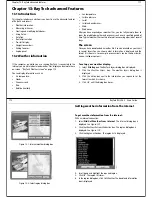


Chapter 13: RayTech advanced features
133
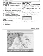
13.7 Pre-start display
The pre-start display - see “Pre-start display” on page 132 can assist you in
making a good start by:
•
Enabling you to calculate the extent and direction of any line bias.
•
Enabling you to decide which end of a line to start, taking into account
line bias, tidal strength, and the angle and direction of likely wind
shifts.
•
Enabling you to select a transit to ensure you know exactly where the
line is.
•
Enable you to position your boat on the line, and create and protect a
space to leeward.
•
Assisting time and distance judgement, so that your boat accelerates
at the right time, hitting the line at full speed.
To set your pre-start co-ordinates:
1. Sail to the port end of the start line and click
Set Port End
.
2. Sail to the starboard end of the start line and click
Set Starb End
.
A Pre-start page is set up showing details such as your angle and dis-
tance from the start line.
If the Pre-start dialog box indicating that your datum longitude is incorrect,
press the Yes button, close the Pre-start page and re-open it. The datum is
corrected.
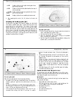
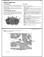
13.8 Route optimization
You can use route optimization to determine your ideal route on any chart
page based upon:
•
Ocean currents.
•
Wind speed and direction.
•
Polar characteristics of your vessel.
To optimize your route:
1. Create a route containing at least the origin and destination
waypoints.
2. Select
File/Set up/Layers
. The Layers dialog box is displayed.
3. Double-click
Weather Routing
. The Weather Routing dialog box is
displayed.
4. Click the action boxes for
Show isochrones, Show paths
and
Show
optimal path
to ON.
5. Click OK. The Weather Routing dialog box closes.
6. Click OK. The Layers dialog box closes.
7.
8. Get the latest weather information from the internet as described in
“Weather information” on page 111 of this manual.
9. Select
Tools/Compute Optimum Route
. The optimum route is
calculated by RayTech and the route time is displayed on screen.
10. Click
OK.
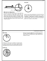
The optimum route is displayed on the chart -see “Optimum
route” on page 135
D8846_1
134
RayTech RNS V6.0 - Users Guide
Isochrone
Optimum route
(calculated path)
D8845_1
Содержание Pathfinder
Страница 1: ......
Страница 26: ...Chapter 5 Using charts 41 42 RayTech RNS V6 0 Users Guide Navionics Platinum cartography D8754_1...
Страница 54: ...Chapter 11 Working with sonar 97 White line D8781_1 98 RayTech RNS V6 0 Users Guide Sonar mark D7004_1...
Страница 58: ...Chapter 11 Working with sonar 105 106 RayTech RNS V6 0 Users Guide RayTech video capture D8784_1...


