background image

Navigation

Starting a Route

1

Search for a location (

Locations

).

2

Select a location.

3

Select 

Go!

.

Previewing Multiple Routes

1

Search for a location (

Finding a Location by Category

).

2

From the search results, select a location.

3

Select 

Routes

.

4

Select a route.

Changing the Route Calculation Mode

1

Select 

Settings

 > 

Navigation

 > 

Calculation Mode

.

2

Select an option:
• Select 

Faster Time

 to calculate routes that are faster to 

drive but can be longer in distance.

• Select 

Off Road

 to calculate point-to-point routes (without 

roads).

• Select 

Less Fuel

 to calculate routes that are more fuel-

efficient.

• Select 

Shorter Distance

 to calculate routes that are 

shorter in distance but can take more time to drive.

Navigating Off Road

If you are not following roadways as you navigate, you can use 

Off Road mode.

1

Select 

Settings

 > 

Navigation

.

2

Select 

Calculation Mode

 > 

Off Road

 > 

Save

.

The next route will be calculated as a straight line to the 

location.

Starting a Route to a Saved Location

1

Select 

Where To?

 > 

Saved

.

2

If necessary, select a category, or select 

All Saved Places

.

3

Select a location.

4

Select 

Go!

.

Navigating to Locations Within a Venue

When navigating to a venue that contains more than one point 

of interest, the device lists additional points of interest located 

within the venue.

1

Search for a venue, such as a mall or airport.

2

Select the venue.
A list of categories appears below the venue.

3

Select a category.

4

Select a point of interest, and select 

Go!

.

Exploring a Venue

You can view a list of all points of interest located within each 

venue.

1

Select a venue.

2

Select   > 

Explore this Venue

.

3

Select a category.

4

Select a point of interest.

5

Select 

Go!

.

Your Route on the Map

NOTICE

The speed limit feature is for information only and does not 

replace your responsibility to abide by all posted speed limit 

signs and to use safe driving judgment at all times. Garmin will 

not be responsible for any traffic fines or citations you receive for 

failing to follow all applicable traffic laws and signs.

The route is marked with a magenta line. A checkered flag 

marks your destination.
As you travel, the device guides you to the destination with voice 

prompts, arrows on the map, and directions at the top of the 

map. If you depart from the original route, the device 

recalculates the route and provides new directions.
A data field displaying the current speed limit may appear as 

you travel on major roadways.
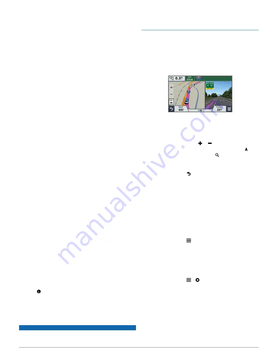
Using the Map

1

Select 

View Map

.

2

Select anywhere on the map.

3

Select an option:
• To zoom in or out, select   or  .
• To switch between North Up and 3-D views, select  .
• To view specific categories, select  .

Adding a Point to a Route

Before you can add a point, you must be navigating a route.

1

From the map, select   > 

Where To?

.

2

Search for a location.

3

Select a location.

4

Select 

Go!

.

5

Select 

Add to Active Route

.

Taking a Detour

Before you can take a detour, you must be navigating a route 

and you must add the change route tool to the map tools menu 

(

Customizing the Map Tools

).

You can take a detour for a specified distance along your route 

or detour around specific roads. This is useful if you encounter 

construction zones, closed roads, or poor road conditions.

1

From the map, select   > 

Change Route

.

2

Select an option:
• To detour your route for a specific distance, select 

Detour 

by Distance

.

• To detour around a specific road on the route, select 

Detour by Road

.

Stopping the Route

From the map, select   >  .

Viewing Route Activity

Viewing a List of Turns

While navigating a route, you can view all of the turns and 

maneuvers for your entire route and the distance between turns.

1

While navigating a route, select the text bar on the top of the 

map.

2

Select a turn.
The details for the turn appear. If available, an image of the 

junction appears for junctions on major roadways.

Navigation

5

Содержание nuvi 57

Страница 1: ...n vi 57 58 67 68 Owner s Manual November 2014 Printed in Taiwan 190 01806 00_0A...

Страница 2: ...of Garmin Ltd or its subsidiaries registered in the USA and other countries These trademarks may not be used without the express permission of Garmin BaseCamp ecoRoute Garmin Express HomePort MapSourc...

Страница 3: ...Up Ahead 6 Finding Upcoming Points of Interest 6 Customizing the Up Ahead Categories 6 Trip Information 6 Viewing Trip Data from the Map 6 Viewing the Trip Information Page 6 Viewing the Trip Log 6 R...

Страница 4: ...oving the Mount from the Suction Cup 12 Removing the Suction Cup from the Windshield 12 Purchasing Additional Maps 12 Purchasing Accessories 12 Troubleshooting 12 The suction cup will not stay on my w...

Страница 5: ...del includes a n Maps Lifetime subscription which provides quarterly map updates for the useful life of your device For terms and conditions go to www garmin com us maps numaps _ lifetime LMT This mod...

Страница 6: ...e You can select some icons to change settings or view additional information GPS signal status Current time Battery status Viewing GPS Signal Status Hold for three seconds Battery Information After t...

Страница 7: ...e the map layer for places along the road Customizing the Map Layers 1 Select View Map 2 Drag and zoom the map to display the area to search 3 If necessary select and select a category icon to view on...

Страница 8: ...r more category names separated by commas 6 If necessary select a suggested category 7 Select Done Deleting a Saved Location NOTE Deleted locations cannot be recovered 1 Select Where To Saved 2 Select...

Страница 9: ...l posted speed limit signs and to use safe driving judgment at all times Garmin will not be responsible for any traffic fines or citations you receive for failing to follow all applicable traffic laws...

Страница 10: ...p Tools 1 Select View Map 2 Select Trip Data 3 Select a trip data field 4 Select an option The new trip data field appears in the trip data list Viewing the Trip Information Page The trip information...

Страница 11: ...in two dimensions 2 D with your direction of travel at the top Select North Up to display the map in 2 D with north at the top Select 3 D to display the map in three dimensions 3 Select Save Safety C...

Страница 12: ...ur device acquires satellite signals while receiving traffic signals from the pay service provider Viewing Traffic Subscriptions Select Settings Traffic Subscriptions Adding a Subscription You can pur...

Страница 13: ...trip with multiple stops Turn off the air conditioner and open your windows unless you are traveling at high speeds on the highway Tighten your gas cap Park in the shade or in the garage Unload exces...

Страница 14: ...r Windows computers select the Safely Remove Hardware icon in the system tray and select your device For Mac computers drag the volume icon to the trash 2 Disconnect the cable from your computer Custo...

Страница 15: ...rchase additional map data Travel History Allows the device to record information for the myTrends Where I ve Been and Trip Log features Clear Travel History Clears your travel history for the myTrend...

Страница 16: ...ard Removing the Mount from the Suction Cup 1 Turn the device mount to the right or left 2 Apply pressure until the socket on the mount releases the ball on the suction cup Removing the Suction Cup fr...

Страница 17: ...age mode My device does not appear as either a portable device or a removable drive or volume on my computer 1 Disconnect the USB cable from your computer 2 Turn off the device 3 Plug the USB cable in...

Страница 18: ...und 3 saving 4 searching for 3 setting home 4 simulated 4 M map layers customizing 7 map tools 7 map view 2 D 7 3 D 7 maps 5 6 10 browsing 3 data field 6 7 detail level 10 layers 7 lifetime 1 n Maps G...

Страница 19: ...setting 6 viewing 6 trip log viewing 6 trip planner 9 editing a trip 9 troubleshooting 12 13 turn list 5 U unit ID 11 up ahead customizing 6 finding services 6 updating maps 1 software 1 USB disconnec...

Страница 20: ...39 02 36 699699 52 001 855 792 7671 0800 0233937 47 815 69 555 00800 4412 454 44 2380 662 915 35 1214 447 460 386 4 27 92 500 0861 GARMIN 427 646 27 0 11 251 9999 34 93 275 44 97 46 7744 52020 886 2 2...

Страница 21: ...om GARMIN...

Страница 22: ...ndbucher Manuah Manuales Handletdmgen Brukervellednmger Manuais Handbocker Manuals Vejledninger Oppaat Manuels Handbucher Manuali Manuales Handletdingen garmin com manuals nuvi57 58 a_ 1 1 garmin com...

Страница 23: ...913 397 8200 1 800 800 1020 c J 00800 4412 454 44 2380 662 915 386 4 27 92 500 886 22642 9199 ext2 49 0 180 6427646 20 ct Anruf a d ____ _ deutschen Festnetz Mobilfunk max 60 ct Anruf Garmin and the G...

Страница 24: ...onen 11 Informacion importante sabre el producto ytu seguridad 14 lnforma9oes importantes de seguran9a edo produto 16 Belangrijke veiligheids en productinformatie 19 Vigtige produkt og sikkerhedsinfor...

Страница 25: ...safety while driving For safety always resolve any discrepancies before continuing navigation and defer to posted signs and conditions The device is designed to provide route suggestions It is not a...

Страница 26: ...e responsible for any traffic fines or citations that you may receive for failing to follow all applicable traffic laws and signs Product Environmental Programs Information about the Garmin product re...

Страница 27: ...obtained and or used in contravention ofthe laws of any country 4 Our navigation products are intended to be used only as atravel aid and must not be used for any purpose requiring precise measuremen...

Страница 28: ...ant les pedales ou les leviers de transmission Ne posez pas le support sur le tableau de bard du vehicule sans le fixer Ne placez pas l appareil devant ou au dessus d un airbag o II n est pas necessai...

Страница 29: ...September 2014 2011 2014 Garmin Ltd or its subsidiaries Printed in Taiwan 190 00720 71_0H...

Отзывы: