Garmin GXM 30A Скачать руководство пользователя страница 18


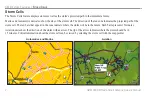
GXM 30A XM Radio Smart Antenna Owner’s Manual
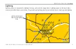
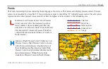
Surface Winds

Marine and Automotive units shows Surface Winds with a wind barb. The wind barb is a circle with a tail. The circle points into the 

wind. Wind speed is indicated by the different combination of flags that are attached to the tail.

Wind Direction

Calm

5 knots

10 knots

15 knots

20 knots

50 knots

Surface Winds

XM W

eather

 f

eatures

 > 

s

urface

 W

Inds

Содержание GXM 30A

Страница 1: ...Owner s Manual GXM 30A...

Страница 2: ...ium to be viewed and to print one copy of this manual or of any revision hereto provided that such electronic or printed copy of this manual must contain the complete text of this copyright notice and...

Страница 3: ...ly as an aid for VFR navigation Use weather data only as an aid to situational awareness Warning Do not mount where driver s field of vision is blocked Do not place unsecured on the vehicle dash Do no...

Страница 4: ...ed to determine ground proximity for aircraft navigation Caution NOTICE TO DRIVERS IN CALIFORNIAAND MINNESOTA State law prohibits drivers in California and Minnesota from using suction mounts on their...

Страница 5: ...ut of your new system take the time to go through this manual and the unit s Owner s Manual Operational procedures are found in the unit s Owner s Manual This manual discusses how to connect the GXM 3...

Страница 6: ...ted on the Information sub tab of your unit If your unit is lost or stolen XM Satellite Radio can deactivate this radio code when you call Serial Number for GXM 30A Use this area to record the serial...

Страница 7: ...ls 9 Hurricanes 10 Surface Winds 11 Winds Aloft 12 Surface Pressure 13 Fronts 14 Visibility 15 County Warnings 16 Water Temperature 17 Wave Period 17 Wave Direction 18 Wave Height 18 Marine Warnings 1...

Страница 8: ...rage Do not store the GXM 30A where exposure to temperature extremes may occur as permanent damage may result UNIT CARE The Garmin GXM 30A has no user serviceable parts Should you ever encounter a pro...

Страница 9: ...s has a clear view of the sky This can be on the outside of the vehicle or behind the windscreen of the vehicle Connect the GXM 30A to the USB port on the Garmin unit GXM 30 XM Radio Smart Antenna Own...

Страница 10: ...ss MENU twice to show the Main Menu A list of tabs appear down the left hand side of the Main Menu Using the ROCKER key highlight the XM tab and select the Information sub tab Write down the Radio ID...

Страница 11: ...indicates that all channels on XM s basic radio service are being received If within an hour the XM WX Weather and or the XM Radio service has not activated call XM WX customer care at 800 985 9200 t...

Страница 12: ...nterpretation if the source that provides the information changes XM WX Weather data is broadcast at set rates See page 29 for all weather related broadcast rates For example NEXRAD Radar data is broa...

Страница 13: ...me Stamp The Time Stamp displays the elapsed time since the National Weather Service provided the displayed information To display a legend showing the colors for Rain Mix and Snow press MENU highligh...

Страница 14: ...te Mosaic Satellite Mosaic displays infrared composite images of cloud cover taken by geostationary weather satellites The Satellite Mosaic provides up to seven levels of cloud cover XM Weather Featur...

Страница 15: ...ng bolt icons as shown in the images below Lightning appears on the map if strikes were detected within the last seven minutes The ground based lightning detection network only detects cloud to ground...

Страница 16: ...icates the projected path of the storm cell The red bars that appear in the cone indicate where the storm will be in the future Each bar represents 15 minutes Aviation units show the direction of the...

Страница 17: ...pression as well as its projected path indicated by a red line The darkened squares that appear along the red line display the projected locations received from the National Hurricane Center The Cente...

Страница 18: ...ace Winds with a wind barb The wind barb is a circle with a tail The circle points into the wind Wind speed is indicated by the different combination of flags that are attached to the tail Wind Direct...

Страница 19: ...s aloft using wind barbs or a wind streamline depending on the zoom range of the map Similar to Marine and Automotive units the wind barbs indicate wind speed and direction The wind streamline indicat...

Страница 20: ...ssure areas are generally associated with fair weather Low pressure areas are generally associated with clouds and the chance of precipitation Isobars that are packed closely together show a strong pr...

Страница 21: ...t Trough Indicates a Low Pressure Center A Low Pressure Center is an area where the measured pressure is lowest relative to the surrounding area Moving away from a Low Pressure Center in any horizonta...

Страница 22: ...the Visibility feature show the forecasted change in surface visibility In the example below visibility ranges from 1 mile to 4 5 miles Visibility Contour Lines This image displays NEXRAD Radar Satel...

Страница 23: ...a county the county is highlighted with the color corresponding to the warning To view information about the warning select the county with the map pointer For more detail press ENTER Tornado Warning...

Страница 24: ...ature feature displays the water s surface temperature The temperature breaks are indicated by isotherm lines Wave Period The Wave Period feature provides the time in seconds between successive waves...

Страница 25: ...shows the direction in which a wave is moving as indicated by the direction of the red arrow Wave Height The Wave Height feature displays wave heights The wave heights for an area are separated by co...

Страница 26: ...arning is issued the area for the warning is highlighted in red To view information about the warning select the warning area with the map pointer To view more detailed information press ENTER XM Weat...

Страница 27: ...m buoys and coastal observation stations These readings are used to determine Air Temperature Dewpoint Water Temperature Tide Wave Height and Period Wind Direction and Speed Visibility and Barometric...

Страница 28: ...o the airport To view the METAR data select the flag with the map pointer To view more detailed information press ENTER VFR ceiling greater than 3000 feet AGL and visibility greater than 5 miles Margi...

Страница 29: ...due to changing weather conditions or issuance cancellation of a SIGMET AIRMETs are displayed as a colored dashed line To view AIRMET data select the AIRMET using the map pointer To view detailed inf...

Страница 30: ...ity to less than three statute miles A Convective SIGMET is issued for thunderstorms isolated severe thunderstorms embedded thunderstorms hail at the surface and tornadoes A SIGMET is widespread A SIG...

Страница 31: ...d TFRs are routinely issued for occurrences such as sporting events dignitary visits military depots and forest fires TFRs are represented as an area highlighted by Red active or Yellow not yet active...

Страница 32: ...at which precipitation is falling Echo Tops at or above the altitude you select are displayed in 5 000 foot increments up to 70 000 ft Echo Tops can be helpful in determining the severity of thunderst...

Страница 33: ...Forecast displays Fronts High and Low Pressure Centers and City Conditions The forecast can be viewed in 12 hour increments for the next 48 hours Freezing Level Contours Forecast map XM Weather Featu...

Страница 34: ...our forecasts on wind visibility expected weather conditions and wind shear XM Radio The XM Audio feature requires a subscription to XM Radio Channels can be scanned by category and saved to a Favorit...

Страница 35: ...Temp Range 40F to 185F 40C to 85C Case Fully sealed high impact plastic with die cast zinc base Waterproof 1 meter submersion for 30 minutes IEC 60529 IPX7 Mount Thread Size M3 x 0 5 Cable Braided sh...

Страница 36: ...sibility Forecast 12 mins Fronts 12 mins Water Temperature 12 mins Wave Height 12 mins Wave Period 12 mins Wave Direction 12 mins Feature Data Broadcast Frequency Buoy Reports 12 mins City Forecast 12...

Страница 37: ...robes and spurious radar data Sun strobes when the radar antenna points directly at the sun Military aircraft deploy metallic dust chaff which can cause alterations in radar scans Interference from bu...

Страница 38: ...o the right Display Rain Display Snow dBZ Rain inches hour Snow inches hour Remarks Rain Snow 10 00 00 10 00 00 5 00 trace 0 00 trace 05 Very Light 5 00 trace 10 Light 10 0 trace 01 Light Light 15 01...

Страница 39: ...th the instructions However there is no guarantee that interference will not occur in a particular installation If this equipment does cause harmful interference to radio or television reception which...

Страница 40: ...RIGHTS WHICH MAY VARY FROM STATE TO STATE IN NO EVENT SHALL GARMIN BE LIABLE FOR ANY INCIDENTAL SPECIAL INDIRECT OR CONSEQUENTIAL DAMAGES WHETHER RESULTING FROM THE USE MISUSE OR INABILITY TO USE THIS...

Страница 41: ...nline auction International Purchases A separate warranty is provided by international distributors for units purchased outside the United States This warranty is provided by the local in country dist...

Страница 42: ...min You agree not to decompile disassemble modify reverse assemble reverse engineer or reduce to human readable form the Software or any part thereof or create any derivative works based on the Softwa...

Страница 43: ...ranties express and implied with respect thereto or the transmission or reception thereof XM and Garmin further do not warrant the accuracy reliability completeness or timeliness of the traffic and we...

Страница 44: ...NGA b The DAFIF product is provided as is and no warranty express or implied including but not limited to the implied warranties of merchantability and fitness for particular purpose or arising by sta...

Страница 45: ...eezing level 26 fronts 14 fronts map 14 G ground clutter 30 H high pressure center 14 26 hurricanes 10 I icing 26 IFR 21 interference 30 introduction iii isobars 13 L lightning 8 lightning bolt icons...

Страница 46: ...30 surface pressure 13 surface winds 11 T TAF 27 temporary flight restriction 24 terminal aerodrome forecast 27 TFR 24 time stamp 6 tornado warning 16 tropical depression 10 tropical storm 10 trough 1...

Страница 47: ......

Страница 48: ...armin com Copyright 2006 Garmin Ltd or its subsidiaries Garmin International Inc 1200 East 151st Street Olathe Kansas 66062 U S A Garmin Europe Ltd Unit 5 The Quadrangle Abbey Park Industrial Estate R...

Отзывы: