5-98
Pilot’s Guide
190-02327-03 Rev. C
Hazard Awareness
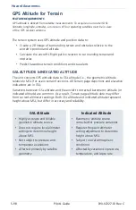
GPS Altitude for Terrain
FEATURE REQUIREMENTS
GPS altitude is derived from satellite measurements. To acquire an accurate 3D fix
(latitude, longitude, altitude), a minimum of four operating satellites must be in view
of the GPS receiver antenna.
The terrain system uses GPS altitude and position data to:
•
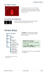
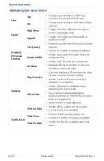
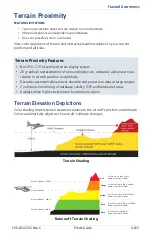
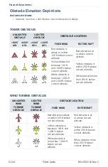
Create a 2D image of surrounding terrain and obstacles relative to the
aircraft’s position and altitude
•
Calculate the aircraft’s flight path in relation to surrounding terrain and
obstacles
•
Predict hazardous terrain conditions and issue alerts
GSL ALTITUDE & INDICATED ALTITUDE
The unit converts GPS altitude data to GSL altitude (i.e., the geometric altitude
relative to MSL) for use in terrain functions. All Terrain page depictions and elevation
indications are in GSL.
Variations between GSL altitude and the aircraft’s corrected barometric altitude (or
indicated altitude) are common. As a result, Terrain page altitude data may differ
from current altimeter readings. Both GSL altitude and indicated altitude represent
height above MSL, but differ in accuracy and reliability.
GSL Altitude
Indicated Altitude
•
Highly accurate and reliable
geometric altitude source
•
Does not require local altimeter
settings to determine height
above MSL
•
Not subject to pressure and
temperature variations
•
Affected primarily by satellite
geometry
•
Barometric altitude source
corrected for pressure variations
•
Requires frequent altimeter
setting adjustment to determine
height above MSL
•
Subject to local atmospheric
conditions
•
Affected by variations in pressure,
temperature, and lapse rate
Содержание GTN 625Xi
Страница 1: ...GTN Xi Series Pilot s Guide...
Страница 12: ...x Pilot s Guide 190 02327 03 Rev C INTENTIONALLY LEFT BLANK...
Страница 25: ...1 System at a Glance OVERVIEW 1 2 PILOT INTERFACE 1 5 COMPATIBLE EQUIPMENT 1 20...
Страница 142: ...2 98 Pilot s Guide 190 02327 03 Rev C INTENTIONALLY LEFT BLANK...
Страница 143: ...3 Navigation MAP 3 4 CHARTS 3 47 WAYPOINTS 3 53 ACTIVE FLIGHT PLAN 3 73 DIRECT TO 3 110 PROCEDURES 3 118...
Страница 309: ...5 Hazard Awareness WEATHER AWARENESS 5 3 TRAFFIC AWARENESS 5 70 TERRAIN AWARENESS 5 97...
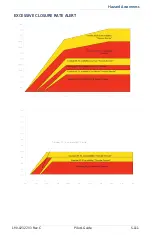
Страница 419: ...Hazard Awareness 190 02327 03 Rev C Pilot s Guide 5 111 EXCESSIVE CLOSURE RATE ALERT...
Страница 450: ...5 142 Pilot s Guide 190 02327 03 Rev C INTENTIONALLY LEFT BLANK...
Страница 451: ...6 Abnormal Operations EMERGENCY DESCENT 6 2...
Страница 454: ...6 4 Pilot s Guide 190 02327 03 Rev C INTENTIONALLY LEFT BLANK...
Страница 455: ...7 Services SIRIUSXM AUDIO ENTERTAINMENT 7 3 CONNEXT SERVICES 7 9...
Страница 478: ...7 24 Pilot s Guide 190 02327 03 Rev C INTENTIONALLY LEFT BLANK...
Страница 479: ...8 Messages ADVISORY MESSAGES 8 2...
Страница 508: ...8 30 Pilot s Guide 190 02327 03 Rev C INTENTIONALLY LEFT BLANK...
Страница 517: ...10 Practice DEMO MODE 10 2...
Страница 529: ...12 Regulatory Information COMPLIANCE 12 2 SOFTWARE LICENSE AGREEMENT 12 3...
Страница 532: ...12 4 Pilot s Guide 190 02327 03 Rev C INTENTIONALLY LEFT BLANK...
Страница 533: ......
Страница 534: ...190 02327 03 Rev C...

