8-9
190-01004-03 Rev. N
GTN 625/635/650 Pilot’s Guide
Foreword
Getting
Started
Audio &
Xpdr Ctrl
Com/Nav
FPL
Direct-To
Proc
Wpt Info
Map
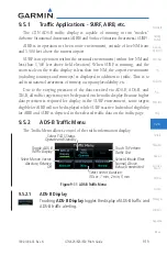
Traffic
Terrain
Weather
Nearest
Services/
Music
Utilities
System
Messages
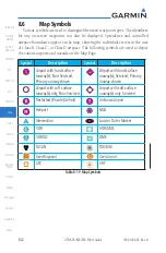
Symbols
Appendix
Index
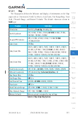
8.1.2
Map Setup
Road Detail
City Detail
State/Province Names
River/Lak
e Detail
Restore Defaults
Range
Type
Restore Defaults
Airport Range
SafeT
axi Diagr
ams
Runw
ay Extensions
Intersection Range
NDB Range
VOR Range
VRP Range
User W
aypoint
Range
Airw
ay Range
TFRs
Restore Defaults
Smart Airspace
Show Airspaces
Class B/TMA Range
Class C/TCA Range
Class D Range
Restricted Range
MOA (Military) Range
Other/ADIZ Range
Restore Defaults
W
eather Source
Cell Movement
MET
AR
Cloud T
ops
Echo T
ops
Lightning
Restore Defaults
Orientation
North
Up Above
Visual APPR
Sel
Auto Zoom
Auto Zoom Min
Auto Zoom Max
Track V
ector
Length
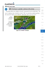
Altitude Constr
aints
Nav Range Ring
Fuel Range Ring
Fuel
Reserve T
ime
Topo Scale
Point Obstacle Rng
Wire Obstacle Rng
Chart Color
Restore Defaults
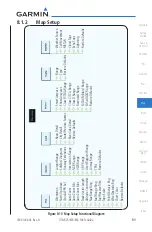
Figure 8-10 Map Setup Functional Diagram

