Failure to avoid the following potentially hazardous situations may
result in injury or property damage.
The GPSMAP 278 is designed to provide you with route suggestions. It
does not reflect road closures or road conditions, traffic congestion, weather
conditions, or other factors that may affect safety or timing while driving.
Use the GPSMAP 278 only as a navigational aid. Do not attempt to use the
GPSMAP 278 for any purpose requiring precise measurement of direction,
distance, location, or topography.
The Global Positioning System (GPS) is operated by the United States
government, which is solely responsible for its accuracy and maintenance.
The government’s system is subject to changes which could affect the
accuracy and performance of all GPS equipment, including the GPSMAP
278. Although the GPSMAP 278 is a precision navigation device, any
navigation device can be misused or misinterpreted and, therefore, become
unsafe.
Map Data Information:
One of the goals of Garmin is to provide customers with the most complete and accurate cartography that is available to us at a reasonable
cost. We use a combination of governmental and private data sources, which we identify in product literature and copyright messages displayed to the consumer.
Virtually all data sources contain inaccurate or incomplete data to some extent. In some countries, complete and accurate map information is either not available or
is prohibitively expensive.
G
ETTING
S
TARTED
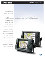
Unit Overview
The GPSMAP 278 is an all-in-one, versatile color chartplotter and automobile navigator—perfect for land or water. This portable
GPS navigator features a 256-color TFT display that is easy to read in bright sun and includes a built-in worldwide basemap. The
GPSMAP 278 comes preloaded with City Navigator
®
NT Europe, which contains street maps and a points of interest (POIs) database,
including motels, restaurants, fuel, ATMs and more. In addition, GPSMAP 278 accepts customized points of interest such as school zones
and safety cameras and includes proximity alerts to warn you of upcoming POIs.
External power
connector under
weather cap
USB connector
under weather cap
Slot for optional data card
Battery pack. Press tab down
to remove battery pack for
replacement, if necessary.
Backlit keypad for easy nighttime operation
GPS antenna
256-Color TFT display
with backlighting
Detachable GPS antenna
collapses for storage.
Be sure the antenna
is up (as shown
here) to receive
satellite signals. See
the
,
page
, for
instructions on
removing the
antenna.
Serial number
GPSMAP 278 Owner’s Manual
1
G
ETTING
S
TARTED
>
U
NIT
O
VERVIEW
Содержание GPSMAP 278 - Marine GPS Receiver
Страница 1: ...Owner s Manual GPSMAP 278...
Страница 137: ......