background image

54

Reference

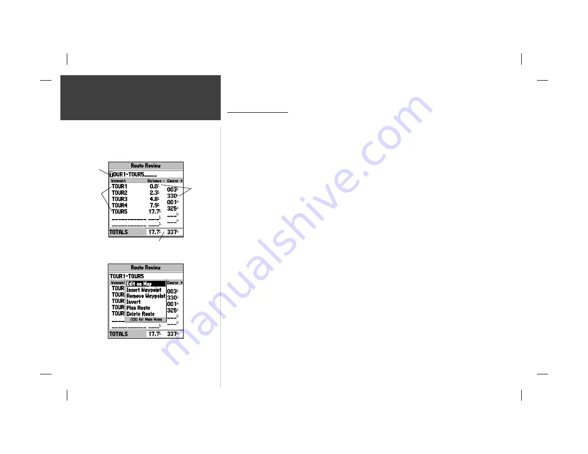
Route Review Page

Route Review Page

Once you have created a route, the Route Review page allows you to review and modify the 

route displayed. 

To view the Route Review page:

1.   Press

 MENU

 twice, then highlight the ‘Route’ tab.

2.   Highlight the name of the route you wish to review and press 

ENTER/MARK

.

The Route Review page also allows you to enter your own 15-character name for any listed route. 

By default the name includes the fi rst and last waypoints in the route. 

To enter a custom route name:

1.   From the Route Review page, highlight the name fi eld and press 

ENTER/MARK

 to begin editing.

2.   Use the 

ARROW KEYPAD

 to enter the desired name and press 

ENTER/MARK

 when fi nished. 

Once you are on the Route Review page, you may review the route points (waypoints or map 

items) one at a time from the list:

To review individual route points:

1.   Highlight the desired point and press 

ENTER/MARK

.


2.   On the Waypoint Review page, you may choose ‘Delete’ (permanently delete the waypoint from 

the unit) ‘Show On Map’ (show the selected point on the Map Page) or ‘Next’ (highlight the next 
point on the route list).

If the route point is a map item, you may choose ‘Create Waypt’ to turn it into a permanent 

waypoint.  Once you are back on the Route Review page, the next point in the route will automatically 
be highlighted.  This allows you to review each point on the route by pressing only 

ENTER/MARK 

repeatedly.

Route Review Menu Options

Menu options available from the Route Review page are Edit on Map, Insert/Add Waypoint, 

Remove Waypoint, Invert, Plan Route, and Delete Route. 

Route Review Options Menu

Route 
Points

Data
Fields

Route 
Name

Data Totals

Содержание GPSMAP 162 Sounder

Страница 1: ...owner s manual and reference guide chartplotting receiver GPSMAP 162 162 new cover indd 11 30 01 9 19 AM 1 ...

Страница 2: ...sseminated downloaded or stored in any storage medium for any purpose without prior written consent of GARMIN Corporation GARMIN Corporation hereby grants permission to download a single copy of this manual onto a hard drive or other electronic storage medium to be viewed for personal use provided that such electronic or printed copy of this manual or revision must contain the complete text of thi...

Страница 3: ...d references to the advanced features and operations of the GPSMAP 162 This allows you to concentrate on a specific topic quickly and look up detailed information about the GPSMAP 162 Customer Service Product Registration Help us better support you by completing our on line registration today Have the serial number of your GPSMAP 162 handy and connect to our website www garmin com Look for the Prod...

Страница 4: ...interference to radio communications There is no guarantee that interference will not occur in a particular installation If this equipment does cause harmful interference the user is encouraged to try to correct the interference by relocating the equipment or connecting the equipment to a different circuit Consult an authorized dealer or other qualified technician for additional help if these remed...

Страница 5: ...OSE STATUTORY OR OTHERWISE THIS WARRANTY GIVES YOU SPECIFIC LEGAL RIGHTS WHICH MAY VARY FROM STATE TO STATE IN NO EVENT SHALL GARMIN BE LIABLE FOR ANY INCIDENTAL SPECIAL INDIRECT OR CONSEQUENTIAL DAMAGES WHETHER RESULTING FROM THE USE MISUSE OR INABILITY TO USE THIS PRODUCT OR FROM DEFECTS IN THE PRODUCT SOME STATES DO NOT ALLOW THE EXCLUSION OF INCIDENTAL OR CONSEQUENTIAL DAMAGES SO THE ABOVE LIM...

Страница 6: ...mpact plastic alloy case waterproof to IEC 529 IPX 7 Advanced Navigating and Plotting 500 alphanumeric waypoints with selectable icons and comments Built in Americas basemap to 20 miles includes detailed ocean river and lake coastlines cities interstates US state highways and local thoroughfares 20 reversible routes with up to 30 waypoints each Uploadable maps up to 2 5 Megabytes of data using GAR...

Страница 7: ...Lights CD ROMs Power Data Cable AC Power PC Interface Cable Protective Cover Owner s Manual and Quick Reference Guide Included with part number 010 00191 00 Included with part number 010 00192 00 Included with part number 010 00192 03 Optional Accessories Cigarette Lighter Adapter PC Interface Cable EURO A C PC Adapter MapSource CDs Fishing Hot Spots BlueChart US Waterways Lights US Topo US Roads ...

Страница 8: ... Options 35 Highway Page and Options 36 Waypoints 38 Creating 38 Reviewing and Editing 40 Options 42 Nearest 44 Proximity 44 vii Introduction Table of Contents Going to a Destination 46 TracBack 48 MOB 50 Routes 51 Creating 51 Route List Page 53 Reviewing and Editing 54 Active Route Page 58 Main Menu Page 59 Track Tab 60 Trip Time and Pages Tabs 62 System Tab 63 Units Tab 64 Communication Tab 66 A...

Страница 9: ... the operate the unit s function keys 1 Mark your present location as a waypoint 10 38 39 Go to a destination 11 14 46 50 Create and use a route 51 58 Learn about the Map page 8 9 22 27 Pan using the map arrow 9 23 Zoom in or out on the Map page 9 27 Reconfigure the Map page display 28 34 Access the Main Menu 16 59 Change units of measure statute nautical metric 64 65 Change the displayed time zone...

Страница 10: ...p Page The ENTER MARK Key The ENTER MARK key selects a highlighted menu option When entering data it allows you to initiate entry and then to accept the selected value s It also marks the current location as a waypoint when pressed and held for more than one second The QUIT Key The QUIT key returns the display to the previous page and when entering data it restores the previous value cancels data ...

Страница 11: ...ting or choosing an item in a list or a field box on a page 2 Use the ARROW KEYPAD to move the cursor highlight up and down a list or up down and sideways on menus 3 Once you have moved to the selection desired press the ENTER MARK key to either activate the feature or pop up a sub menu or list of yet more feature options Just repeat this process to select an option from the list or press the QUIT ...

Страница 12: ...gh the list Pressing and holding the keypad moves you rapidly through the list 4 Use the ARROW KEYPAD LEFT RIGHT arrows to move to the next character on the line or backwards to edit characters If there are more than two lines of data keep pressing to the RIGHT to drop down to the next line 5 When data entry is completed press ENTER MARK to accept data then move to the next programmable field Not a...

Страница 13: ...162 is shipped from the factory in AutoLocate mode which will allow the receiver to find itself anywhere in the world To speed up the initialization process we recommend using the graphic initialization process described on the next page which will usually provide a position fix within a few minutes Before you initialize make sure the GPSMAP 162 unit and antenna have been correctly installed on your...

Страница 14: ...it switches to the Map Page or displays 2D or 3D Navigation during this process it is not necessary to initialize the unit The GPSMAP 162 will now begin searching for the appropriate satellites for your region and should acquire a fix within a few minutes A signal strength bar for each satellite in view will appear on the top middle of the page with the appropriate satellite number under each bar T...

Страница 15: ...r configuration To turn on the GPSMAP 162 1 Press and hold the POWER key until the power tone sounds then release the POWER key The Welcome Page will appear while the unit conducts a self test 2 Once the self test is complete press the ENTER MARK key if you agree to acknowledge the warning The Status Page will appear as the receiver begins acquiring satellites From the Status Page or any other page...

Страница 16: ... let s put the GPSMAP 162 into simulator mode To place the GPSMAP 162 in simulator mode 1 From the Status Page press the MENU key A menu of options and functions for the Status Page will appear 2 Press UP DOWN on the ARROW KEYPAD to highlight the Start Simulator option and press ENTER MARK 3 Press the ENTER MARK key to confirm the Running Simulator message that appears at the bottom of the display ...

Страница 17: ...e and edit waypoints and routes Before we take off on our practice route let s take a brief look at its various features and displays The map display shows your boat as a triangle marker on an electronically generated chart Geographic names roads markers and buoys that are provided by the optional MapSource data are also shown It also displays your track routes and nearby waypoints An on screen cu...

Страница 18: ...oat to the cursor along with the latitude longitude of the cursor 3 Press the QUIT key to remove the cursor and re center your boat on the map display As you become more familiar with the cursor you ll see that the map display actively scrolls or pans letting you explore areas around the world and create waypoints and routes Wherever you move the cursor you ll always be just one QUIT keystroke awa...

Страница 19: ...you are done simply press ENTER MARK again and move the highlight to where you left off 5 After you have entered all the letters press ENTER MARK to confirm the name 6 To access the waypoint symbol menu highlight the waypoint symbol field which is to the left of the waypoint s name and press ENTER MARK Note The default symbol is a dot 7 You will see an alphabetical list of available waypoint symbols...

Страница 20: ...an on screen waypoint or map item as a destination directly from the Map Page and pressing NAV MOB allows you to graphically select points to Go To For our simulated trip you re going to select a pre programmed tour route using the first method This will also show you how the MENU key provides tab style options and functions throughout the GPSMAP system Let s start by changing the position to where...

Страница 21: ...chained together in a simple route with your boat at the first route waypoint A data field at the top of the page will now display the speed distance to the second route waypoint and a pointer which shows you which way to go To get started let s enter a speed for our vessel which we can do from the Main Menu Page To enter a boat speed 1 Press the MENU key twice to display the Main Menu Page 2 Use th...

Страница 22: ...ld at the top of the page will display the waypoint name the range and bearing from your present position and the coordinates for the waypoint To review the waypoint page for a selected waypoint 1 Press the ENTER MARK key 2 To return to the Map Page press ENTER MARK again or press QUIT The cursor can also be used to create new waypoints right from the map display To create a new waypoint using the...

Страница 23: ...irection of the destination bearing relative to the course over ground The compass ring and pointer arrow work independently to show at a glance the direction of your movement and the direction to your destination For instance if the arrow points up you are going directly to the waypoint If the arrow points any direction other than up turn toward the arrow until it points up then continue in that ...

Страница 24: ... the Compass Page when your main concern is following a defined course Whenever the GPSMAP 162 is in simulator mode you can also adjust your speed and course from the Highway Page using the ARROW KEYPAD As you head toward each waypoint in the tour route try adjusting your boat speed and course to get a feel for how the highway works To adjust the simulated boat speed from the Highway Page 1 Press t...

Страница 25: ...Active Route Page Whenever you have activated a route or TracBack this page will show each waypoint name along with useful data for each point As you navigate the route the information will automatically update to indicate the next point along the route which is denoted by an arrow on the left hand side of the screen For more detailed information on the Active Route Page see page 58 As you ve seen...

Страница 26: ...ption and press ENTER MARK A confirmation page will appear 2 Highlight the OK prompt and press ENTER MARK to confirm 3 Press PAGE or QUIT to return to any of the main pages Congratulations You ve now gone through the basic operation of the GARMIN GPSMAP 162 Your new digital chartplotter is a powerful tool with many advanced features not covered in the Getting Started tour For detailed instructions o...

Страница 27: ...looking for a particular satellite the corresponding signal strength bar will be blank and the sky view indicator will not be highlighted Once the receiver has found the satellite a light signal strength bar will appear indicating that the satellite has been found When the receiver has collected data from the satellite and locked on the number in the sky view will appear highlighted and the status...

Страница 28: ...wn or initialized position but has not collected enough data to calculate a fix 2D Navigation at least three satellites with good geometry have been acquired and a 2 dimensional position fix latitude and longitude is being calculated 2D Differential Naviga tion will appear when you are receiving DGPS corrections in 2D mode and a D will show on the strength bar of satellites being corrected 3D Naviga...

Страница 29: ... with 30db being the best the strength of the DGPS signal being received If no optional DGPS receiver is used with the GPSMAP 162 the DGPS Rcvr field will display Off and the DGPS SNR field will be blank The SNR will depend upon the mounting of your DGPS receiver and the distance from the DGPS transmitting station Many features of the GPSMAP 162 are menu driven Each of the main pages has an options ...

Страница 30: ... You must have a clear unobstructed view of the sky for the GPSMAP 162 to be able to receive a WAAS signal Even then at times it may not be possible to receive a WAAS signal For more information on the WAAS system visit the Federal Aviation Administration web site at gps faa gov Track Up North Up allows you to select between a north up or track up sky view display for the Status Page only Loran TD...

Страница 31: ... or map item The map scale displays at the bottom right of the page The IN and OUT keys combined with the ARROW KEYPAD let you select zoom ranges and move the cursor Two basic map operating modes position mode and cursor mode determine what cartography is shown on the map display Position mode pans the cartography to keep the present position marker within the display area while cursor mode pans t...

Страница 32: ...p the unit may pause as it loads new map data Using the Cursor The cursor allows you to pan away from your present position and scroll to other map areas around the world even outside of your current MapSource coverage As you pan past the edge of the current map display the screen will actively scroll forward to provide continuous map coverage To move the cursor 1 Press the ARROW KEYPAD to move th...

Страница 33: ...PAD to highlight a map item with the cursor and press ENTER MARK The Map Feature Review page will appear 2 Use the ARROW KEYPAD to view the tabbed information Each tab shows the name of the map feature the distance and bearing from your current location and offers additional options 3 To center the selected map item on the Map Page use the ARROW KEYPAD to highlight the Show on Map button and press...

Страница 34: ... year to fish that area and the best types of lures for catching certain fish in that area To view Fishing Hot Spots information 1 Use the ARROW KEYPAD to select a map item or map location within the Fishing Hot Spots coverage area and press ENTER MARK 2 Use the ARROW KEYPAD to view the tabbed information pages for that location Highlight OK and press ENTER MARK when you re finished You may also sele...

Страница 35: ...lected map item on the Map Page use the ARROW KEYPAD to highlight the Show on Map button and press ENTER MARK The Map Feature page appears with the map feature name distance and bearing from your current position and position coordinates Press QUIT once to return to the Map Feature Review page or press QUIT twice to return to the Map Page 5 To create a waypoint from one of the tabbed information p...

Страница 36: ... IN key to zoom in The scale value represents the distance from one end of the scale bar to the other The GPSMAP 162 s system has a built in worldwide database to 20 mi with more detailed coverage available through the use of the optional MapSource software The GPSMAP 162 will display cartography as long as there is chart information available for the range you ve selected Map coverage will confor...

Страница 37: ...splayed The GPSMAP 162 s Map Page provides access to functions and features relating to the Map Page and the layout options To display the Map Page options 1 Press MENU To select a menu option 1 Use the ARROW KEYPAD to highlight the desired option and press ENTER MARK The available options are Full Screen Map On Full Screen Map Off Measure Distance Configure Map Setup Page Layout and Change Data Fi...

Страница 38: ...he top of the display 4 Press the QUIT key to finish Configure Map allows you to configure the map display to your preferences including map detail map orientation automatic zoom and various map items and points The map configuration option uses a file tab feature making it easier to organize the various settings for ease of use The following table lists the file tabs and the settings available under ea...

Страница 39: ...tain zoom scales General Tab Detail Most More Normal Less Least controls how much map detail you will see This setting only applies to any map feature set to Auto Those features which have a specified scale or turned Off are unaffected by this setting Orientation North Up fixes the top of the map display to a north heading Track Up fixes the top of the map display to the current track heading Course ...

Страница 40: ...gation line from the point navigation was initiated to a destination waypoint Track Tab Saved Tracks Track Log Zoom settng see the description on page 30 for details Geo Tab Geo Points Rivers Lakes Park Areas Text and Zoom settngs see the description on page 30 for details Topo Tab Major Medium Minor Contours Land Cover Text and Zoom settngs see the description on page 30 for details Other Tab Acc...

Страница 41: ...ap Page To display the MapSource Info Page 1 From the Map tab press MENU then highlight MapSource Info and press ENTER MARK 2 Use the ARROW KEYPAD to scroll through the list of downloaded maps 3 To select deselect a map highlight the name of the desired map Press ENTER MARK to select deselect the map The map is selected and will be displayed on the Map Page when a 9 appears in the box adjacent to ...

Страница 42: ...PTH Depth below transducer only available with additional sonar NMEA data DIST TO DEST Distance to final waypoint DIST TO NEXT Distance to next waypoint ETA AT DEST Estimated Time of Arrival to final waypoint ETA AT NEXT Estimated Time of Arrival to next waypoint ELEVATION Elevation above below MSL Mean Sea Level MAX SPEED Fastest speed the unit has traveled MOV AVG SPEED Average moving speed MOV TR...

Страница 43: ... Speed through the water only available with additional sonar NMEA data WATER TEMP Water temperature only available with additional sonar NMEA data To change a data field 1 From the menu use the ARROW KEYPAD to highlight the Change Data Fields option and press ENTER MARK 2 Move the field highlight to the data field you want to change and press ENTER MARK 3 Move up or down on the ARROW KEYPAD to highl...

Страница 44: ...irection of your movement and the direction to your destination For instance if the arrow points up you are going directly to the waypoint If the arrow points any direction other than up turn toward the arrow until it points up then continue in that direction The GPSMAP 162 s Compass Page features a menu page that provides access to layout and data field options The data window located at the top o...

Страница 45: ...d in or out to display a larger or smaller view of the highway Five settings are available from 1X to 16X with a default setting of 8X To change the highway perspective scale 1 Press the IN or OUT key to select the desired setting The GPSMAP 162 s Highway options page allows you to define the data fields and select which waypoints are displayed on screen The data window located at the top of the pag...

Страница 46: ...ure Highway and press ENTER MARK 2 Highlight the desired option and press ENTER MARK Setup Page Layout allows you to change the text size and number of data fields that will be displayed Change Data Fields allows you to specify the type of data displayed in each data field used on the map display For detailed instructions on changing the data fields and layout of the Highway page see pages 32 34 Acti...

Страница 47: ...our present position This can be determined by looking at the Status Page When you move the cursor over a map item you will see a highlighted description of that item To mark your present position 1 Press and hold the ENTER MARK key until the New Waypoint window appears then release it You will see a default three digit name and symbol for the new waypoint 2 To accept the waypoint with the default...

Страница 48: ...hically 1 Use the ARROW KEYPAD to move the cursor to the desired map position If you want to create the new waypoint at an on screen map item highlight the map item on the map display 2 Press and quickly release the ENTER MARK key The New Map Waypoint page appears NOTE Pressing and holding the ENTER MARK key will mark your current location instead of the cursor location and bring up the New Waypoi...

Страница 49: ...AD to enter the new information and press ENTER MARK after the last character in each section 5 When you have finished highlight OK and press ENTER MARK Reviewing and Editing Waypoints Once you have created and stored a waypoint it may be reviewed modified moved or deleted at any time through the Waypoint Review and Waypoint Edit pages On the Waypoint Review page you may change the name symbol posit...

Страница 50: ...hlight the waypoint symbol field to the left of the waypoint name and press ENTER MARK 2 Use the ARROW KEYPAD to select the desired symbol and press ENTER MARK when done To change the position coordinates 1 Highlight the position coordinate field and press ENTER MARK 2 Use the ARROW KEYPAD to edit the coordinates To drop to the next line press to the right on the ARROW KEYPAD Press ENTER MARK when d...

Страница 51: ...t which displays a master list of all waypoints currently stored in memory From the By Name list you may review edit rename or delete individual waypoints or delete all user waypoints The total number of stored and available waypoints is displayed at the bottom of the By Name page with the stored waypoints arranged in numerical alphabetical order The following options are available from the By Nam...

Страница 52: ...he ENTER MARK key to confirm the deletion warning To delete waypoints by symbol 1 From the By Name tab highlight the waypoint to be deleted and press MENU Select Delete By Symbol and press ENTER MARK 2 Use the ARROW KEYPAD to highlight the symbol of the waypoint s to be deleted and press ENTER MARK 3 Press ENTER MARK to confirm You may also choose Cancel or press QUIT to stop the deletion To delete ...

Страница 53: ...ght OK and press ENTER MARK To select a nearest waypoint as a NAV MOB destination 1 Use the ARROW KEYPAD key to select the desired waypoint 2 Press NAV MOB followed by ENTER MARK Proximity Waypoint List The third waypoint submenu list available from the Waypt tab is the Proximity list which lets you define an alarm circle around a stored waypoint position and can be used to help you avoid reefs roc...

Страница 54: ...ab and press the MENU key To add a proximity waypoint 1 From the Proximity tab menu options use the ARROW KEYPAD to highlight Add Waypoint and press ENTER MARK The Find screen appears 2 Use the ARROW KEYPAD to select a catagory from the Find list Select a point from the chosen catagory and press ENTER The Waypoint Review page will be displayed 3 Press ENTER MARK to confirm The distance field will no...

Страница 55: ...Destination Using the NAV MOB key the GPSMAP 162 provides four ways to navigate to a destination Go To Waypoint Follow Track TracBack MOB Man OverBoard and Follow Route navigation Once you are actively navigating you will see a straight line that always runs from the point where you started the GOTO to the destination The easiest method for selecting a destination is the Go To function which lets ...

Страница 56: ...n the GPSMAP 162 will automatically use the name of the map item but the point will not be stored in the waypoint list See page 39 for creating waypoints using map items If you are selecting a new map point non map item as the Go To destination the GPSMAP 162 will automatically create or move a waypoint named MAP at the cursor position To activate an existing waypoint or map item as a Go To from t...

Страница 57: ...KEYPAD highlight the Track tab then highlight the Active tab to the right 3 Use the ARROW KEYPAD to select the Clear option and press ENTER MARK 4 Highlight the OK field and press ENTER MARK You must first save the track log before you can use the Follow Track feature The Save feature allows you to store a track log from certain times and dates To save a track log 1 From the Main Menu use the ARROW ...

Страница 58: ...he Record Mode option on the track log setup page must be set to Fill or Wrap There must be at least two track log points stored in memory to create a TracBack route If the track log interval is set to the Time option the route may not follow your exact path keep the interval set to resolution for best performance If the receiver is turned off or satellite coverage is lost during your trip the Tra...

Страница 59: ...ed a MOB waypoint with a diver down symbol will be created and the unit will be on an active navigation to that point Use any of the Navigation Pages to guide you back to the MOB point The MOB waypoint will be stored in the waypoint list and may be deleted like any other waypoint To stop navigation to the MOB position 1 Press the NAV MOB key highlight Stop Navigation and press ENTER MARK 2 Choose ...

Страница 60: ...e Main Menu page 2 Use the ARROW KEYPAD to highlight the Route tab and press the MENU key to display the route options page 3 Select the New Route option and press ENTER MARK 4 Use the ARROW KEYPAD to highlight the first field under the word Waypoint and press ENTER MARK 5 From the Find list choose a catagory then choose a point from that catagory Press ENTER MARK to display a review page With the O...

Страница 61: ... distance from your location and coordinates of the cursor The top data window shows the name of the route as it is being created using the beginning and end points as the default name The bottom of the display shows the number of available and used points A route line appears on the map to indicate each completed leg and a dotted line appears to indicate the distance and bearing to the arrow curs...

Страница 62: ...atically display Follow the route name 2 Highlight the route you wish to navigate and press ENTER MARK 3 Choose Activate or Invert and Activate and press ENTER MARK Activate will use the route as is Invert and Activate will reverse the route then activate it To deactivate stop navigation of a route 1 Press the NAV MOB key highlight Stop Navigation and press ENTER MARK 2 Choose either Yes or No and...

Страница 63: ...ew page you may review the route points waypoints or map items one at a time from the list To review individual route points 1 Highlight the desired point and press ENTER MARK 2 On the Waypoint Review page you may choose Delete permanently delete the waypoint from the unit Show On Map show the selected point on the Map Page or Next highlight the next point on the route list If the route point is a...

Страница 64: ...R MARK again when done To remove a route point 1 Place the cursor on the desired point and press MENU Select Remove and press ENTER MARK To move a route point 1 Place the cursor on the desired point and press MENU Select Move and press ENTER MARK The cursor will now have Move displayed below it 2 Move the cursor to the new map position and press ENTER MARK to relocate the point To add turns at the...

Страница 65: ... insert a point into the route or add a point to the end 1 From either the Route Review or Active Route pages use the ARROW KEYPAD to highlight the point you wish to insert the new point before to add a point to the end highlight the blank field at the bottom of the list 2 Press MENU highlight Add Waypoint or Insert Waypoint and press ENTER MARK 3 From the Find list select a point to be inserted ad...

Страница 66: ...vailable planning figures appears to the right of each route waypoint and its distance Use the LEFT RIGHT keys on the ARROW KEYPAD to select the desired item 3 To enter planning information Press MENU select Plan Route from the options list and press ENTER MARK Enter the figures for Speed Fuel Flow Depart ure Time and Depart ure Date Press QUIT to return to the Route Plan Page Fuel flow rates on your...

Страница 67: ...e and Route Review pages share many of the same features and options The following route options are available from the active route page Edit on Map see page 55 for instructions Add Waypoint see page 56 for instructions Remove Waypoint see pages 55 for instructions Invert see page 57 for instructions Plan Route see page 57 for instructions Re evaluate recalculates and reactivates the current rout...

Страница 68: ...the highlighted tab will automatically appear to the right 2 If you want to highlight any of the tab items press to the RIGHT on the ARROW KEYPAD then move UP or DOWN to select individual items 3 You may then press either MENU for additional submenu options or press ENTER MARK to make changes to the highlighted item 4 Press LEFT on the ARROW KEYPAD to get back to the Menu tab list Pressing QUIT wi...

Страница 69: ...rack memory or start a TracBack route See pages 48 49 for TracBack information The Track submenu is divided in two tabs Active tab and the Saved tab The Active tab is for the active log the log currently being recorded It displays track memory used and current settings The Saved tab displays and manages a list of any saved track logs allows TracBack activation map display of saved logs The active ...

Страница 70: ...ar allows you to clear the active track log currently stored in memory For the Saved tab the following menu options are available Show Map displays the saved track log on a Track Map page Delete Track deletes highlighted saved track log from memory Delete All deletes all saved track logs from memory You may also activate a TracBack from any of the saved tracks on this tab To activate a TracBack fr...

Страница 71: ...ahead or behind the time line See the table on page 74 for time offsets Daylight Savings choose from Auto On or Off to adjust for daylight savings Pages Tab allows you to turn on off any of the main pages or Jump To a particular page To select deselect a main page 1 Use the ARROW KEYPAD to highlight the box to the left of the page name Pressing ENTER MARK will select deselect that page When a page...

Страница 72: ...es for the unit s on screen display System Mode select from Normal Normal Navigation or Simulator For practice ONLY Track Control Auto Track will steer to the current navigation point User Track allows you to enter a heading in the Track field Speed lets you enter a speed Track lets you enter a heading Set Position allows to set your location while in simulator mode See page 11 starting with step 2...

Страница 73: ...or additional information on Loran TD setup see pages 72 73 Map Datum allows you to select the datum reference used to determine a given position The default setting is WGS 84 Datums are used to describe geographic positions for surveying mapping and navigation and are not actual maps built in the unit Although over 100 datums are available as listed on pages 77 78 you should only change the datum...

Страница 74: ...immediately to the right and press ENTER MARK 2 Use the ARROW KEYPAD to enter the magnetic variation at your current position and press ENTER MARK WARNING If User Mag Var is selected you must periodically update the magnetic variation as your position changes Using this setting the unit will not automatically calculate and update the magnetic variation at your present position Failure to update th...

Страница 75: ...p feature Text Out outputs simple text ASCII output which contains time position and velocity data RTCM In allows DGPS input using a standard RTCM format without any output capabilities RTCM In NMEA Out allows Differential GPS DGPS input using a standard RTCM format and also provides NMEA 0183 version 2 3 output RTCM In Text Out allows Differential GPS DGPS input using a standard RTCM format and a...

Страница 76: ...y enter a frequency and bit rate 1 With the unit set to Garmin DGPS or RTCM In NMEA Out use the ARROW KEYPAD to highlight the Beacon field and press ENTER MARK 2 Highlight User and press ENTER MARK 3 Highlight the Frequency or Bit Rate field press ENTER MARK then enter a frequency or bit rate and press ENTER MARK when done The Status field will show one of the following Tuning unit is attempting to t...

Страница 77: ...ist Distance or Time Off Course sets an alarm to sound when you re off a desired course by a specified distance Enter a distance in the distance field and use the control field to turn the off course alarm on and off Clock provides an alarm for the system clock Enter a time in the time field and turn the alarm on and off from the control field menu Remember to enter alarm times in the same time format ...

Страница 78: ... Time tab on the Main Menu see page 74 To select a different location 1 From the Celes tab use the ARROW KEYPAD to highlight the position field and press ENTER MARK The Find page will be displayed 2 Select a FInd catagory and then select a point from that catagory Press ENTER MARK to display a review page then press ENTER MARK confim the selection To change the time or date 1 From the Celes tab use ...

Страница 79: ...rrows at the ends of the line will indicate the time of day when using current date and will intersect the tide graph to show their relation The tide curve shows as a shaded area with higher tides being taller and lower tides shorter The dark horizontal line with arrows at the ends of the line indicates the current tide height The figure to the left of the line will show the current tide level in f...

Страница 80: ...hlight the On field and press ENTER MARK 2 Enter the desired date and press ENTER MARK To use the current date 1 Press MENU then highlight Use Today s Date and press ENTER MARK WARNING When you load MapSource data into the GPSMAP 162 the tide station information provided with the unit will be deleted Replacement tide station data for the GPSMAP 162 can be found on our web site www garmin com If you...

Страница 81: ...mode it simulates the operation of a LORAN receiver Position coordinates may be displayed as TDs and all navigation functions may be used as if the unit was actually receiving LORAN signals Using the LORAN TD Format When creating new waypoints using LORAN TD coordinates you must set the correct LORAN chain number and secondary stations in the Setup TD field before storing the waypoint After the way...

Страница 82: ... change the settings of any of the five fields highlight the field press ENTER MARK select enter the desired setting and press ENTER MARK 3 When done press the QUIT key to return to the Status Page If the active GRI Chain secondary stations or offsets have been changed since the waypoint was created the waypoint will now reference the active GRI chain and secondary stations and adjust the TD coordina...

Страница 83: ... 1 W007 5º to E007 5º 0 E007 5º to E022 5º 1 E022 5º to E037 5º 2 E037 5º to E052 5º 3 E052 5º to E067 5º 4 E067 5º to E082 5º 5 E082 5º to E097 5º 6 E097 5º to E112 5º 7 E112 5º to E127 5º 8 E127 5º to E142 5º 9 E142 5º to E157 5º 10 E157 5º to E172 5º 11 E172 5º to E180 0º 12 A simple way to determine your local time offset is how many hours you are behind or ahead of UTC also called Greenwich o...

Страница 84: ...ap data Database Error Internal problem with unit Contact your dealer or GARMIN Customer Service pg iv to have the unit serviced Lost Satellite Reception The unit has lost satellite signals Check antenna connections or try moving to a location with a clear view of the sky Memory RAM Failed Unit Needs Repair Internal problem with unit Contact your dealer or GARMIN Customer Service pg iv to have the...

Страница 85: ...runcated Uploaded route from other device has more than 30 points Reduce number of points Running Simulator Unit is in simulator practice mode Track Already Exists track name You have entered a saved track name that already exists in memory Modify track name or delete the previous track name Track Memory Is Full Can t Create Track Track log memory is full No additional track log data can be stored...

Страница 86: ...karta Batavia Sumatra Island Indonesia Dos 1968 Dos 1968 Gizo Island New Georgia Islands Dutch Dutch Easter Isld 67 Easter Island 1967 European 1950 European 1950 Austria Belgium Denmark Finland France Germany Gibraltar Greece Italy Luxembourg Netherlands Norway Portugal Spain Sweden Switzerland European 1979 European 1979 Austria Finland Netherlands Norway Spain Sweden Switzerland Finland Hayfrd ...

Страница 87: ...Saudi A Nahrwn Saudi Arabia Nhrwn United A Nahrwn United Arab Emirates Obsrvtorio 66 Observatorio 1966 Corvo and Flores Islands Azores Old Egyptian Old Egyptian Egypt Old Hawaiian Old Hawaiian Mean Value Oman Oman Oman Ord Srvy GB Old Survey Great Britain England Isle of Man Scotland Shetland Island Wales Pico De Las Nv Canary Islands Potsdam Potsdam Germany Prov S Am 56 Prov South American 1956 B...

Страница 88: ...imate Time of Arrival The estimated time you will reach your destination waypoint based on current speed and track ETA at Destination The estimated time you will reach a GOTO destination or the final waypoint in a route ETA at Next The estimated time you will reach a GOTO destination or the next waypoint in a route Fuel The fuel required to travel from present position to the indicated route waypoi...

Страница 89: ...nt in a route To Course The recommended direction to steer in order to reduce course error or stay on course Provides the most efficient heading to get back to the desired course and proceed along your route Track The direction of movement relative to a ground position Also referred to as ground track Trip Odometer A running tally of distance travelled since last reset Also see Odometer Total Avera...

Страница 90: ...rformance Receiver Differential ready 12 parallel channel receiver tracks all satellites in view Acquisition Times Warm Approx 15 seconds Cold Approx 45 seconds AutoLocate Approx 5 minutes Update Rate 1 second continuous Accuracy Position 15 meters 49 feet RMS 1 5 meters 3 15 feet RMS with optional GARMIN DGPS receiver Velocity 0 1 knot RMS steady state Dynamics 6g s Subject to accuracy degradatio...

Страница 91: ...arine VHF and LORAN antennas should not seriously degrade the GPS antenna s reception Never paint the antenna or clean it with harsh solvents The GARMIN antenna screws directly onto any standard 1 x 14 thread antenna mount If you need to raise the antenna to avoid shading try using a 1 x 14 thread extension mast available at most marine dealers To install the GPS antenna 1 Screw the antenna direct...

Страница 92: ...tion Avoid mounting the unit where it will be blocked by the boat s superstructure a radar arch or mast The temperature range for the GPSMAP 162 is 5 F to 158 F 15 C to 70 C Extended exposure to temperatures exceeding this range in storage or operating conditions may cause failure of the LCD screen This type of failure and related consequences are NOT covered by the manufacturer s limited warranty...

Страница 93: ...2 3 ASCII Text Output RTCM SC 104 input version 2 0 The following are the sentences for NMEA 0183 version 2 3 output Approved sentences GPRMC GPGGA GPGSA GPGSV GPGLL GPBOD GPRTE and GPWPL Proprietary sentences PGRME PGRMZ and PSLIB The GPSMAP 162 also includes NMEA input with support for the WPL sentence and Sonar NMEA input with support for the DPT MTW and VHW sentences You can download a copy of...

Страница 94: ...ransmission can be customized to keep the output rate at two seconds If the unit is setup to output all of the available NMEA sentences the output rate may exceed two seconds The Advanced NMEA Output Setup page will allow you to turn On Off the GPS Status GSA GSV Waypoint Route WPL RTE and the GARMIN Proprietary sentences You can also change the precision of the Lat Lon Minutes Advanced NMEA Outpu...

Страница 95: ...hway 37 Configuring the Map 29 Contrast Setting 6 Cursor Movement 9 23 27 D Data Fields 33 34 Data Transfer 66 Date Time 18 62 69 Datum Map 64 77 78 Daylight Savings Time 62 Deep Water Alarm 68 Depth 65 DGPS Interface Settings 66 68 DGPS Status 19 20 67 68 Differential Receiver Status 20 Dilution Of Precision DOP 19 Distance Speed and Altitude 65 E Editing Routes 55 57 Editing Waypoints 40 41 ENTER...

Страница 96: ... 44 NMEA Output Formats 66 84 O Odometers Trip 62 Off Course Alarm 68 OUT Key 1 Overzoom 27 P Packing List vi PAGE Key 1 Pages Tab 59 62 Plan Route 57 Position Format 64 Power Off 17 Power On 4 6 Power Backlight Contrast Key 1 Preface ii Proximity Waypoints 44 46 Q QUIT Key 1 R Receiver Status 18 19 Re evaluate Active Route 58 Registration ii Restore Garmin Setup 63 Restoring Defaults 31 32 Review...

Страница 97: ... vii Temperature 65 Tide Charts 70 71 Tide Tab 60 70 71 Time Format 62 Time Offsets 74 Time Tab 59 62 Time Zone 58 TracBack 48 49 61 Track Log Clearing 17 48 61 Deleting 61 Saving 48 61 Showing on Map 30 37 49 61 Track Tab 60 61 Trip and Fuel Planning 57 Trip Odometers 62 Trip Tab 62 Trip Timers 62 U Units Tab 60 64 65 User Datum 77 78 W WAAS 21 Warnings iii Warranty iv Water Mode 31 WaypointLists...

Страница 98: ...89 ...

Страница 99: ... Olathe Kansas 66062 U S A GARMIN Europe Ltd Unit 5 The Quadrangle Abbey Park Industrial Estate Romsey SO51 9AQ U K GARMIN Asia Corporation No 68 Jangshu 2nd Road Shijr Taipei County Taiwan www garmin com Part Number 190 00169 00 Rev C 162 new cover indd 11 30 01 9 19 AM 2 ...

Отзывы: