8-4
Garmin G600 Pilot’s Guide
190-00601-02 Rev. B
For
ewor
d
Sec 1 System
Sec 2
PFD
Sec 3
MFD
Sec 4
Hazar
d
Avoidance
Sec 5
Additional Featur
es
Sec 6
Annun. & Alerts
Sec 7
Symbols
Sec 8
Glossary
Appendix A
Appendix B
Index
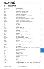
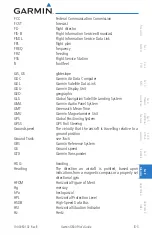
IAF
Initial Approach Fix
ICAO
International Civil Aviation Organization
IFR
Instrument Flight Rules
IGRF
International Geomagnetic Reference Field
ILS
Instrument Landing System
IMC
Instrument Meteorological Conditions
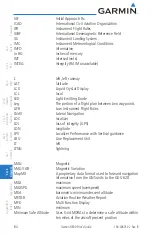
INFO
information
in HG
inches of mercury
INT
intersection(s)
INTEG
integrity (RAIM unavailable)
L
left, left runway
LAT
latitude
LCD
Liquid Crystal Display
LCL
local
LED
Light Emitting Diode
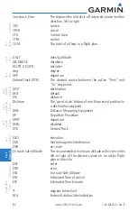
Leg
The portion of a flight plan between two waypoints
LIFR
Low Instrument Flight Rules
LNAV
Lateral Navigation
LOC
localizer
LOI
loss of integrity (GPS)
LON
longitude
LPV
Localizer Performance with Vertical guidance
LRU
Line Replacement Unit
LT
left
LTNG
lightning
MAG
Magnetic
MAG VAR
Magnetic Variation
MapMX
A proprietary data format used to forward navigation
information from the GNS units to the GDU 620
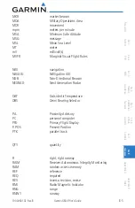
MAX
maximum
MAXSPD
maximum speed (overspeed)
MDA
barometric minimum descent altitude
METAR
Aviation Routine Weather Report
MFD
Multi Function Display
MIN
minimum
Minimum Safe Altitude
Uses Grid MORAs to determine a safe altitude within
ten miles of the aircraft present position
Содержание G600
Страница 1: ...G600 Pilot s Guide ...
Страница 239: ......

