


Garmin G3X Pilot’s Guide
190-01115-00 Rev. K
Appendix C
406
System
Overview
Flight
Instruments
EIS
CNS
Interface
GPS
Navigation
Flight
Planning
Hazar
d
Avoidance
Additional
Featur
es
AFCS
Annun/Alerts
Appendix
Index
• *VORs—identifier, facility name, city/state/country, location (latitude/longitude),
frequency, service volume (high, low, terminal), and type (such as VOR-DME,
TACAN, and VORTAC).
• *NDBs—identifier, facility name, city/state/country, location (latitude/longitude),
and frequency.
• Intersections—identifier, nearest VOR, radial and distance from nearest VOR,
location (latitude/longitude), and region/country.
• ARTCC—Air Route Traffic Control Centers.
• Airspace—boundaries (Class B, Class C, Control Zones, SUAs, and MOAs),
controlling agency, and vertical boundaries.
• FSS—Flight Service Stations.
* Symbology used for NDBs, VORs, and airports is consistent with those used on a
sectional chart.
NOTE:
After performing a navigation database update, verify all flight plan(s)
(routes) are current. If there is an obsolete aviation point in a saved route, the
route is locked and unusable. A new route with current navigation database
points will need to be created.
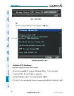
FLITECHARTS
The FliteCharts database contains procedure charts for the United States only. This
database is updated on a 28-day cycle.
CHARTVIEW
ChartView database is revised every 14 days. Charts are still viewable during a
period that extends from the cycle expiration date to the disables date. ChartView is
disabled 70 days after the expiration date and is no longer available for viewing. The
ChartView database is always on the SD Card and is not copied to the GDU’s internal
memory.
Содержание G3X Touch
Страница 1: ...G3X Pilot s Guide ...
Страница 2: ......
Страница 4: ......
Страница 10: ...Garmin G3X Pilot s Guide 190 01115 00 Rev K Warnings Cautions Notes Blank Page ...
Страница 16: ...Garmin G3X Pilot s Guide 190 01115 00 Rev K RR 6 Blank Page ...
Страница 469: ......