SLAM
Simultaneous localization and mapping (SLAM)
is a method used in robotics for creating a map
of the robots surroundings while keeping track of the robots position in that map. The TurtleBot
4 uses
to generate maps by combining odometry data from the Create® 3 with
laser scans from the RPLIDAR.
slam_toolbox
supports both synchronous and asynchronous
SLAM nodes.
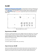
Map generated by slam_toolbox
Synchronous SLAM
Synchronous SLAM requires that the map is updated everytime new data comes in. This results
in maps with high accuracy and detail. The downside to synchronous SLAM is that it requires
high processing power from the computer running it to keep up with the sensor data. This
approach is ideal for use on a PC, whether it is for the simulator or for getting better SLAM
performance on the physical robot.
Launching synchronous SLAM:
ros2 launch turtlebot4_navigation slam_sync.launch.py
Asynchronous SLAM
Asynchronous SLAM will update the map as fast as the processor running it can handle. This
may cause it to drop some laser scans or odometry data. Maps created with asynchronous
SLAM may have reduced accuracy and detail, but this method requires significantly less
Содержание TurtleBot 4 Lite
Страница 50: ...Running the Light Ring test...
Страница 61: ...Adding Displays in Rviz2...
Страница 63: ...Camera image displayed in Rviz2...
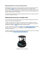
Страница 82: ...TurtleBot 4 Lite with a NED2 arm...
Страница 147: ...Color camera diagnostics...


