Installation and Operation Manual
23
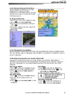
3-4-6 Chart symbols and information
Using C-Map Max card allows you to show
different kind of symbols and their
information on chart plotter display. On some
objects such as a port, you can see a picture
of landscape layout.
To display information
1 Move cursor on an icon to display its name.
2 Press
and select
Chart info
.
3 Move cursor key to highlight an item and
press
.
4 Information related to the item appears at
the bottom window.
[Chart info]
[Chart symbol Data Box]
3-4-7 Introduction to navigating
Use the navigation chart to plan your course, view map information, and as a navigational aid.
This unit has two ways of navigating, going straight to a waypoint or following a route (a
group of waypoints).
3-4-8 Going to a waypoint or to a point on the chart
A waypoint is a particular location on a voyage whether it is a starting, intermediate or
destination point. A waypoint is the simplest piece of information your equipment requires to
get you to a destination. In the shortest distance possible. This unit can save up to 5,000
waypoints.
Goto Cursor Option
1 Press
and select the
Chart
window.
2 Move the cursor to the destination point.
3 Press
and select
Goto cursor
to
start navigating.
Goto WPT Option
1 Press
and select the
Chart
window
2 Move the cursor to place cursor on a
waypoint.
3 Press
and select
Goto WPT
to start
navigating.
Find Option
1 Press
and select the
Chart
icon.
2 In the
Chart
window, press
and
select
Find
then
Waypoints
.
3 select a waypoint to start navigation.
Make sure the course does
not pass over land or
dangerous waters.
Cancelling navigating
1 Press
and select the
Chart
icon.
2 Press
and select
Cancel Goto
.
Содержание C-56
Страница 62: ...Installation and Operation Manual 62 ...

